
BC tidal area 19 - Victoria, Sidney: Recreational fishing limits, openings and closures
You’re responsible for understanding the regulations and restrictions that may affect an open fishery.
How to follow the rules:
- Check the Area map. You need to know the location (subarea) where you plan to fish.
- Check the species regulations tables for fishing opportunities and basic regulations.
- Check the restrictions tables for special exceptions and more detailed regulations. Make sure you know the:
- (d) Daily limit: The maximum number of a given fish species that a person is allowed to keep in one day.
- (p) Possession limit: The maximum number of fish you can have in your possession at any given time, except for what is at your ordinary residence.
- (a) Annual limit: The total amount of fish of a certain species that may be caught and retained during the course of a fishing year which commences on April 1 and ends the following March 31.
- Get to know the locations of protected areas. Permanent fishing restrictions are in effect in these areas to protect fish and fish habitat.
- Unless otherwise specified, fishing opportunities and closures end at 23:59 hrs on the close-date shown.
Helpful resources:
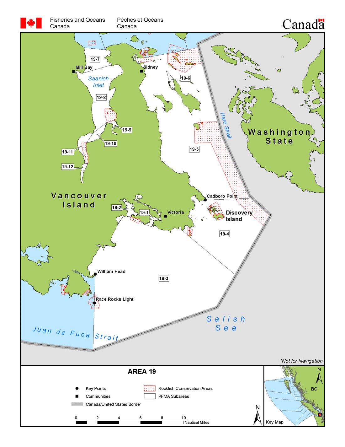
Area map
Area maps
For a written description of Areas please see the Pacific Fishery Management Area Regulations 2007.
Area 19: Download a printable PDF version of this map.
Salmon
Salmon
Species regulations
Always check for restrictions.
| Species | Areas | Min size | Gear | Limits (d/p/a) |
Status |
|---|---|---|---|---|---|
| Chinook salmon | 19-2 | -/-/- | Closed | ||
| Chinook salmon (hatchery) | 19-1,19-3,19-4 | 45cm | Barbless Hook & Line | 1/2/10 | Open until May 31 (See Restrictions) |
| 19-5,19-6 | 62cm | Barbless Hook & Line | 1/2/10 | Open until May 31 (See Restrictions) | |
| 19-7,19-8 | 62cm | Barbless Hook & Line | 1/2/10 | Open until Jul 31 (See Restrictions) | |
| 19-9 to 19-12 | Barbless Hook & Line | 0/0/- | Non-retention until Jul 31 (See Restrictions) | ||
| Chinook salmon (wild) | 19 | Barbless Hook & Line | 0/0/- | Non-retention until Jul 31 (See Restrictions) | |
| Chum salmon | 19 | 30cm | Barbless Hook & Line | 4/8/- | Open (See Restrictions) |
| Coho salmon (hatchery and wild combined) | 19 | Barbless Hook & Line | 0/0/- | Non-retention until May 31 (See Restrictions) | |
| Pink salmon | 19 | 30cm | Barbless Hook & Line | 4/8/- | Open (See Restrictions) |
| Sockeye salmon | 19 | Barbless Hook & Line | 0/0/- | Non-retention (See Restrictions) |
Last updated: 2024-04-03 09:30:51
Restrictions
Always check for protected areas.
| Species | Areas | Measure type | Measure value |
|---|---|---|---|
| Finfish | 19-2 | Closed | Fuel spill - as a precautionary measure, Esquimalt Harbour (Subarea 19-2) is closed to all fishing (effective May 10, 2016 until further notice). |
| Strait of Georgia Dive Closures (Area 19) | Closed | These waters are closed to the harvest of all marine life by divers for the preservation of unique underwater habitat. | |
| Ogden Point | Closed | Closed to spear fishing while diving. | |
| Salmon | Coastwide | Combined Daily Limit Pieces | 4 - The daily limit for all species of Pacific salmon from tidal and fresh waters combined is 4. Individual species limits also apply. |
| Coastwide | Possession Limit Pieces | 8 - The possession limit for all salmon from all waters is twice the daily limit. You cannot possess more than eight salmon in total, except for salmon that are at your ordinary residence. | |
| Chinook salmon | Coastwide | Reminder | Keeping your chinook salmon? You must permanently record all retained catch on your Tidal Waters Sport Fishing Licence. The licence holder may alternatively record retained catch immediately in an electronic licence held in an approved third-party application linked to their National Recreational Licensing System (NRLS) account, or if mobile internet access is immediately available, directly in their NRLS account. The licence holder shall ensure that all mandatory catch records for the current licence year are produced, either on the licence (paper or electronic), or from the licence holder’s NRLS account at the time of inspection. |
| 19 | Annual Limit Pieces | 10 - The coastwide total annual limit for chinook salmon is 10 from all tidal waters that are open to chinook retention. | |
| Coho salmon (hatchery) | Coastwide | Reminder | Hatchery coho (marked): Coho salmon with a healed scar in place of the adipose fin. |
Last updated: 2024-04-03 09:30:15
Area descriptions
| Area | Map | Area description |
|---|---|---|
| Ogden Point | Ogden Point Breakwater; consisting of those waters inside a line from the navigation light at the western end of the causeway, thence to Brotchie Ledge Light, thence to Holland Point on Vancouver Island. | |
| Strait of Georgia Dive Closures (Area 19) | In the Victoria area, Ogden Point Breakwater, consisting of those waters inside a line from the navigation light at the western end of the causeway, thence to Brotchie Ledge Light, thence to Holland Point on Vancouver Island. |
Last updated: 2024-04-03 09:30:15
Other finfish
Finfish other than salmon
Learn more about fishing for finfish
Species regulations
Always check for restrictions.
| Species | Areas | Min size | Gear | Limits (d/p/a) |
Status |
|---|---|---|---|---|---|
| Herring | 19 | Cast Net, Dip Net, Herring Jig, Herring Rake | 20kg/40kg/- | Open (See Restrictions) | |
| Eulachon | 19 | 0/0/0 | Closed | ||
| Mackerel | 19 | Cast Net, Dip Net, Herring Jig, Hook and Line | 100/200/- | Open (See Restrictions) | |
| Northern anchovy | 19 | Cast Net, Dip Net, Herring Jig, Herring Rake | 20kg/40kg/- | Open (See Restrictions) | |
| Other finfish species | 19 | Hook and Line, Spear Fishing while diving | 20/40/- | Open (See Restrictions) | |
| Pacific sand lance | 19 | Cast Net, Dip Net, Herring Jig, Herring Rake | 5kg/10kg/- | Open (See Restrictions) | |
| Pacific sardine | 19 | Cast Net, Dip Net, Herring Jig, Herring Rake | 100/200/- | Open (See Restrictions) | |
| Surf smelt | 19 | Dip Net, Gill Net | 20kg/40kg/- | Open (See Restrictions) | |
| Tuna, Albacore | 19 | Hook and Line, Spear Fishing while diving | 20/40/- | Open (See Restrictions) | |
| Tuna, All other species | 19 | Hook and Line, Spear Fishing while diving | 20/40/- | Open (See Restrictions) | |
| Codfish | 19 | Hook and Line, Spear Fishing while diving | 8/16/- | Open (See Restrictions) | |
| Greenling | 19 | Hook and Line, Spear Fishing while diving | 3/6/- | Open (See Restrictions) | |
| Halibut | 19 | Hook and Line, Spear Fishing while diving | 1/2/10 | Open until Dec 31 (See Restrictions) | |
| Lingcod | 19 | 0/0/0 | Closed until Apr 30 | ||
| Perch | 19 | Hook and Line | 8/16/- | Open (See Restrictions) | |
| Rockfish, All species combined | 19 | 0/0/0 | Closed until Apr 30 | ||
| Rockfish, Yelloweye | 19 | 0/0/0 | Closed until Apr 30 | ||
| Sablefish | 19 | Hook and Line | 4/8/- | Open (See Restrictions) | |
| Sculpin | 19 | Hook and Line | 8/16/- | Open (See Restrictions) | |
| Shark, All other species excluding dogfish | 19 | Hook and Line | 0/0/0 | Non-retention (See Restrictions) | |
| Shark, Basking | 19 | 0/0/0 | Closed | ||
| Shark, Blue | 19 | 0/0/0 | Closed | ||
| Shark, Bluntnose | 19 | 0/0/0 | Closed | ||
| Shark, Brown Cat | 19 | 0/0/0 | Closed | ||
| Shark, Great White | 19 | 0/0/0 | Closed | ||
| Shark, Salmon | 19 | Hook and Line, Spear Fishing while diving | 1/2/- | Open (See Restrictions) | |
| Shark, Sixgill | 19 | 0/0/0 | Closed | ||
| Shark, Tope | 19 | 0/0/0 | Closed | ||
| Skate | 19 | Hook and Line | 1/2/- | Open (See Restrictions) | |
| Sole/Flounder | 19 | Hook and Line, Spear Fishing while diving | 8/16/- | Open (See Restrictions) | |
| Spiny dogfish | 19 | Hook and Line, Spear Fishing while diving | 4/8/- | Open (See Restrictions) | |
| Sturgeon | 19 | Hook and Line | 0/0/0 | Non-retention (See Restrictions) | |
| Trout (hatchery) | 19 | 30cm | Hook and Line | 2/4/- | Open (See Restrictions) |
| Trout (wild) | 19 | 0/0/- | Non-retention (See Restrictions) | ||
| Wolf eel | 19 | Hook and Line | 0/0/0 | Non-retention (See Restrictions) |
Last updated: 2024-04-01 06:22:42
Restrictions
Always check for protected areas.
| Species | Areas | Measure type | Measure value |
|---|---|---|---|
| Finfish | 19-2 | Closed | Fuel spill - as a precautionary measure, Esquimalt Harbour (Subarea 19-2) is closed to all fishing (effective May 10, 2016 until further notice). |
| Strait of Georgia Dive Closures (Area 19) | Closed | These waters are closed to the harvest of all marine life by divers for the preservation of unique underwater habitat. | |
| Ogden Point | Closed | Closed to spear fishing while diving. | |
| Herring | 19 | Reminder | Harvesting of herring roe from marine plants or plants placed in the water for the purpose of harvesting herring roe is prohibited. |
| Eulachon | Coastwide | Closed | Due to conservation concerns the harvesting of eulachon is prohibited. |
| Codfish | Coastwide | Reminder | Species includes: Pacific cod, Pacific tomcod, pollock and hake but does not include lingcod. |
| Halibut | Coastwide | Reminder | As a Condition of Licence, the possession limit for halibut is EITHER of: one (1) halibut measuring 85 cm to 126 cm in length (65 cm to 97 cm head-off), OR two (2) halibut, each measuring under 85 cm in length (65 cm head-off). No person shall retain a halibut greater than 126 cm head-on length (97 cm head-off). Head-off measurements are made from the base of the pectoral fin at its most forward point to the extreme end of the middle of the tail. |
| Coastwide | Maximum Length Head On (cm) | 126 cm - The maximum overall length for halibut is 126 cm head-on, or 97 cm head-off. | |
| Lingcod | Coastwide | Season Planning | For planning purposes only: for in-season requirements, please see current regulations/restrictions for specific areas, gear and individual species limits, and closures/exceptions. INSIDE WATERS - Generally open May 1 to September 30, for Areas 13 to 19 and Subareas 12-1 to 12-13, 12-15 to 12-48, 20-5 to 20-7 and 29-5. Closed year round - Area 28 and Subareas 29-1 to 29-4 and 29-6 to 29-17. OUTSIDE WATERS - Generally open April 1 to November 15, for Areas 1 to 10, 101 to 110, 130, 142, 11, 21 to 27, 111, 123 to 127, Subareas 12-14 and 20-1 to 20-4, and Area 121 (portion). |
| 19 | Reminder | Lingcod: Fillets, including the tail, must meet the minimum "head off" size limit of 53 cm. (21 in.) | |
| Perch | Coastwide | Reminder | Includes kelp, shiner and pile perch, and all species of surf and sea perch. |
| Rockfish, All species combined | Coastwide | Reminder | Rockfish - Anglers in vessels shall immediately return all rockfish that are not being retained to the water and to a similar depth from which they were caught by use of an inverted weighted barbless hook or other purpose-built descender device. |
| Coastwide | Season Planning | For planning purposes only: for in-season requirements, please see current regulations/restrictions for specific areas, gear and individual species limits, and closures/exceptions. INSIDE WATERS - Generally open May 1 to September 30, for Areas 13 to 19 and Subareas 12-1 to 12-13, 12-15 to 12-48, 20-5 to 20-7 and 29-5. Closed year round - Area 28 and Subareas 29-1 to 29-4 and 29-6 to 29-17. OUTSIDE WATERS - Generally Open April 1 to November 15, for Areas 1 to 10, 101 to 110, 130, 142, 11, 21 to 27, 111, 123 to 127, Subareas 12-14 and 20-1 to 20-4, and Area 121 (portion). | |
| Sculpin | Coastwide | Reminder | Cabezon is a species of sculpin; for daily and possession limits, please see the species regulations table above for sculpin. |
| Trout (hatchery and wild combined) | Coastwide | Reminder | Note: (1) Trout - means Brook trout, Brown trout, Cutthroat trout, Dolly Varden, Lake trout, Rainbow trout, Steelhead, and includes Bull trout. (2) Steelhead - in waters where anadromous Rainbow trout are found, Steelhead means a Rainbow trout that is greater than 50cm in overall length. (3) Anadromous means migrating from the sea up rivers or streams to spawn. |
| 19 | Combined Daily Limit Pieces | 2 The aggregate recreational daily limit for wild and hatchery trout combined is two (2). |
Last updated: 2024-04-01 06:10:43
Area descriptions
| Area | Map | Area description |
|---|---|---|
| Ogden Point | Ogden Point Breakwater; consisting of those waters inside a line from the navigation light at the western end of the causeway, thence to Brotchie Ledge Light, thence to Holland Point on Vancouver Island. | |
| Strait of Georgia Dive Closures (Area 19) | In the Victoria area, Ogden Point Breakwater, consisting of those waters inside a line from the navigation light at the western end of the causeway, thence to Brotchie Ledge Light, thence to Holland Point on Vancouver Island. |
Last updated: 2024-04-01 06:10:43
Bivalve shellfish and snails
Bivalve shellfish and snails
Eating contaminated shellfish can be life threatening. Closures change frequently throughout the year. It is illegal to harvest shellfish from closed or contaminated areas.
Bivalve shellfish have 2 hinged shells. Because they feed by filtering microscopic plankton from the water, changes in water quality can cause unsafe marine biotoxins, bacteria, or viruses to build up in their tissue.
Snails refers to all snails, whelks, tritons and periwinkles with the exception of Moon Snails. Snails and moon snails can accumulate toxins and pollutants. We recommend that they not be harvested from areas shown as closed in the table below.
Learn more about shellfish harvesting.
How to follow the rules
- Check for contamination in the subarea where you plan to harvest.
- If no contamination closures are in effect, check species regulations and additional harvest restrictions.
- Littleneck, Manila and butter clams are subject to a minimum size limit. See below under restrictions for more information on clam size limits.
- Questions? Email us at DFO.PACCSSP-PCAMPAC.MPO@dfo-mpo.gc.ca.
Bivalve shellfish contamination closures
Planned bivalve shellfish harvesting closures
Look at the first column below to see which species are safe to harvest. If there is information in the second column, it is illegal and unsafe to harvest any bivalve species in those areas.
| Subarea | Marine biotoxin update (open bivalve species) | Sanitary contamination closures (closed to shellfish harvesting) |
|---|---|---|
| 19-1 | Closed to All Bivalve Species | |
| 19-2 | Closed to All Bivalve Species | |
| 19-3 | Closed to All Bivalve Species | |
| 19-4 | Closed to All Bivalve Species | |
| 19-5 | Clam, Butter;Mussels, All | |
| 19-6 | Closed to All Bivalve Species | |
| 19-7 | Clam, Littleneck;Clam, Manila;Mussels, All;Oyster, Pacific | |
| 19-8 | Clam, Littleneck;Clam, Manila;Mussels, All;Oyster, Pacific | |
| 19-9 | Clam, Littleneck;Clam, Manila;Mussels, All;Oyster, Pacific | |
| 19-10 | Clam, Littleneck;Clam, Manila;Mussels, All;Oyster, Pacific | |
| 19-11 | Clam, Littleneck;Clam, Manila;Mussels, All;Oyster, Pacific | |
| 19-12 | Clam, Littleneck;Clam, Manila;Mussels, All;Oyster, Pacific |
Last updated: 2024-04-01 06:20:57
Species regulations
Always check for restrictions.
| Species | Areas | Gear | Limits (d/p/a) |
|---|---|---|---|
| Clam, Butter | 19 | Hand Digging | 20/40/- |
| Clam, Horse | 19 | Hand Digging | 6/12/- |
| Clam, Littleneck | 19 | Hand Digging | 60/120/- |
| Clam, Manila | 19 | Hand Digging | 60/120/- |
| Clam, Razor | 19 | Hand Digging | 12/24/- |
| Clam, Softshell | 19 | Hand Digging | 25/50/- |
| Clam, Varnish | 19 | Hand Digging | 60/120/- |
| Clams, All | 19 | Hand Digging | 60/120/- |
| Cockles | 19 | Hand Digging | 25/50/- |
| Geoduck | 19 | Hand Digging, Hand Picking | 3/6/- |
| Mussel, Blue | 19 | Hand Picking | 75/150/- |
| Mussel, California | 19 | Hand Picking | 25/50/- |
| Oyster, Olympia | 19 | 0/0/0 | |
| Oyster, Pacific | 19 | Hand Picking | 12/24/- |
| Scallop, Pink and Spiny | 19 | Diving, Hand Picking | 75/150/- |
| Scallop, Rock | 19 | Diving, Hand Picking | 6/12/- |
| Scallop, Weathervane | 19 | Diving, Hand Picking | 6/12/- |
| Snail, Moon | 19 | Hand Picking | 2/4/- |
| Snail, Other | 19 | Hand Picking | 75/150/- |
Last updated: 2024-04-01 06:21:01
Restrictions
Always check for protected areas.
| Species | Areas | Measure type | Measure value |
|---|---|---|---|
| Shellfish | 19-1 | Reminder | Victoria Harbour - Boating/fishing restrictions in Victoria Harbour. Please review important harbour and vessel navigation restrictions from Transport Canada at: https://tc.canada.ca/en/marine-transportation/ports-harbours-anchorages/port-victoria. Download their Port of Victoria Traffic Scheme diagram. Full text of vessel/navigation restrictions is shown at: https://tc.canada.ca/en/marine-transportation/ports-harbours-anchorages/practices-procedures-public-ports#220 Fishing, including the placement of traps, in navigational channels is prohibited; please exercise extreme caution in these areas while obeying Transport Canada navigational procedures. |
| 19-2 | Closed | As a precautionary measure, the May 10, 2016 closure of Esquimalt Harbour (Subarea 19-2) to all fishing due to a fuel spill continues. This closure was recommended by Island Health and will remain in place until testing can be done to determine that all species are safe for human consumption. | |
| 19-2,19-3 | Reminder | Esquimalt Harbour and approaches - Please review important harbour and vessel navigation restrictions, as depicted on Canadian Hydrographic Service Chart 3419. For more details link to: https://www.canada.ca/en/navy/corporate/esquimalt-harbour.html. Fishers are reminded to exercise caution while obeying navigational and use requirements in the harbour and vicinity. | |
| Strait of Georgia Dive Closures (Area 19) | Closed | These waters are closed to the harvest of all marine life by divers for the preservation of unique underwater habitat. | |
| Bivalve Species | Coastwide | Reminder | Clams: No person shall retain a Manila Clam or Littleneck Clam smaller than 35 mm, nor a Butter Clam smaller than 55 mm. |
| Coastwide | Reminder | Because of the risk of contamination, you are not allowed to harvest bivalve shellfish (for any purpose) within: (1) 300 metres around industrial, municipal and sewage treatment plant outfall discharges (2) 125 metres around a marina, ferry wharf, floating living accommodation, or any finfish net pen (exceptions described as follows) (3) 25 meters around any floating living accommodation facility located within a shellfish aquaculture tenure where a zero-discharge and appropriate waste management plan is a condition of the Aquaculture Licence and is approved by the Regional Interdepartmental Committee (4) 0 meters of any finfish net pen within an aquaculture tenure where an Integrated Multi-Trophic Aquaculture Management Plan approved by the Regional Interdepartmental Committee is in operation. | |
| Cadboro Point | Closed | ||
| Ogden Point | Closed | ||
| Ten Mile Point | Closed | ||
| Clams, All | Coastwide | Daily Limit Pieces | 60 - When open, all species aggregate daily limit combined Areas 1 to 27 is 60, except Pacific Rim National Park where the all species aggregate limit is 24. |
| 19 | Gear Restriction | It is illegal to use any mechanical apparatus or dredge for harvesting clams. | |
| Reminder | Clam harvesters are encouraged to fill in holes to reduce predation on exposed juvenile clams. | ||
| Mussels, All | 19 | Reminder | Combined daily limit for all mussel species is 75. |
| Oyster, Pacific | Coastwide | Reminder | To avoid inadvertently harvesting Olympia oysters while you are harvesting Pacific oysters, do not harvest any oyster less than 5 cm in diameter. |
| 19 | Packaging and Transporting | Avoid transfer of green crab - Harvesters are encouraged to shuck oysters on the beach and leave the shells there, or return oyster shells to the beach from where you collected them whenever possible. In order to avoid the transfer of European green crab, please dispose of any oyster shell harvested from the west coast of Vancouver Island back to the beach from where it came or with your household garbage. Consult your local DFO Office. You will need permission to harvest oysters from marked oyster farms. | |
| Snail, Moon | 19 | Reminder | Moon snails may be subject to PSP, check for closures. Consult your local DFO office for details. |
Last updated: 2024-04-01 06:20:52
Area descriptions
| Closure | Map | Area description |
|---|---|---|
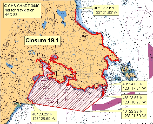
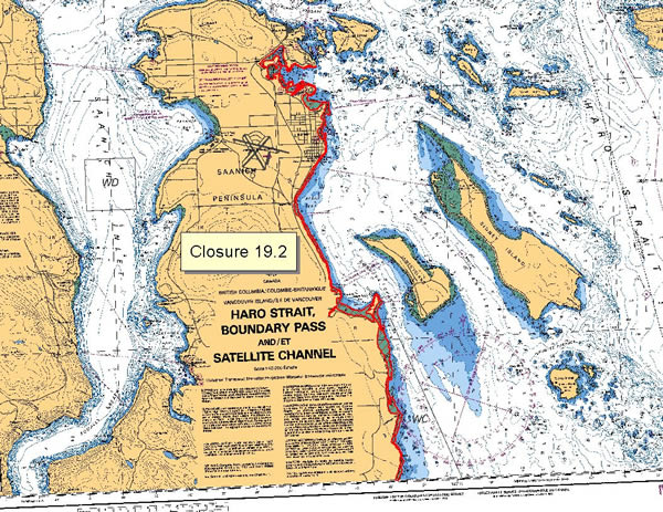
| 19.1 Albert Head to Cordova Bay | 19.1.jpeg | The waters and intertidal foreshore of Vancouver Island, lying inside a line drawn from Albert Head at 48°23.25' north latitude and 123°28.60' west longitude, thence southeasterly to a point in water at 48°22.22' north latitude and 123°21.30' west longitude, thence northeasterly to Staines Point on the Trial Islands at 48°23.67' north latitude and 123°18.27' west longitude, thence northeasterly to Gonzales Point at 48°24.69' north latitude and 123°17.61' west longitude, thence northerly along the intertidal foreshore of Saanich Peninsula to a point on land parallel to the end of Parker Road at 48°32.20' north latitude and 123°21.82' west longitude in Cordova Bay. [NAD83] |
| 19.10 Deep Cove to Patricia Bay | 19.10.jpeg | The waters and intertidal foreshore of northeastern Saanich Inlet, lying inside a line drawn from Moses Point at 48°41.35' north latitude and 123°29.11' west longitude to Coal Point at 48°40.63' north latitude and 123°29.34' west longitude, thence southeasterly to a point on land at 48°38.90' north latitude and 123°27.64' west longitude. [NAD83] |
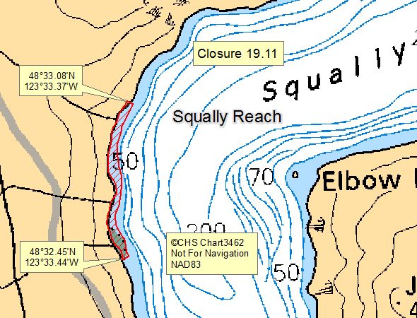
| 19.11 Squally Reach, Saanich Inlet | 19.11.jpeg | The waters and intertidal foreshore of the west side of Squally Reach from a point on land at 48°32.45' N and 123°33.44 W which is located 200 m south of the southernmost creek (Irving Creek), thence following the shoreline northwards along the 10 m depth line, to a point on land at 48°33.08'N and 123°33.37'W, which is 200 m north of the northernmost creek. [NAD83] |
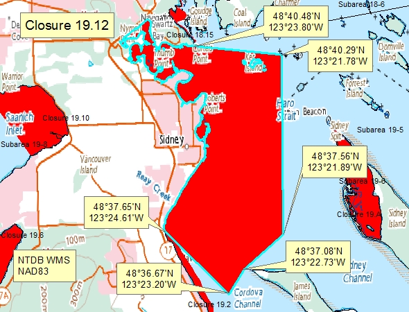
| 19.12 Bazan Bay | 19.12.jpeg | The waters of Bazan Bay, Little Group Islands, and Tsehum Harbour inside a line drawn from a point on land at 48°37.65' N 123°24.61' W thence southeasterly to a point in water at 48°36.67' N 123°23.20' W thence northeasterly to a point in water at 48°37.08' N 123°22.73' W thence northeasterly to a point in water at 48°37.56' N 123°21.89' W thence northerly to a point on Dock Island at 48°40.29' N 123°21.78' W thence northwesterly to Curteis Point at 48°40.48' N 123°23.80' W thence to the point of commencement. [NAD83] |
| 19.13 North Yarrow Point | 19.13.jpeg | The waters and intertidal foreshore of a small bay just north of Coles Bay lying inside a line drawn from a northerly point at 48°38.19' north latitude and 123°28.68' west longitude thence southerly to the opposite shore at 48°37.97' north latitude and 123°28.71' west longitude. [NAD83] |
| 19.14 Saanichton Bay | 19.14.jpeg | The waters of Saanichton Bay south of a line drawn from a point on land on the Saanich Peninsula at 48°36.26' north latitude and 123°23.67' west longitude, thence southeasterly to a point in the water at 48°35.91' north latitude and 123°22.29' west longitude, thence due south to the tip of Cordova Spit. [NAD83] |
| 19.2 Saanich Peninsula, Curteis Point, Cordova Bay | 19.2.jpeg | The intertidal foreshore of Saanich Peninsula, from Curteis Point southward to a point on shore, at 48°32.20' north latitude and 123°21.82' west longitude, parallel with the northern end of Parker Road, Cordova Bay. [NAD 27]. |
| 19.3 West Saanich Inlet | 19.3.jpeg | The waters and intertidal foreshore of Saanich Inlet, including Mill Bay, extending from Hatch Point at 48°41.63' north latitude and 123°32.09' west longitude, thence following the low water mark to a point in water on the low water mark at 48°40.17' north latitude and 123°31.81' west longitude, thence southerly to the northern side of Verdier Point at 48°37.92' north latitude and 123°31.76' west longitude. [NAD 83] |
| 19.4 Thomson Cove, Saanich Inlet | 19.4.jpeg | The waters and intertidal foreshore of Thomson Cove, Saanich Inlet, lying inside a line drawn from the northern headland of Thomson Cove to Henderson Point. [NAD83] |
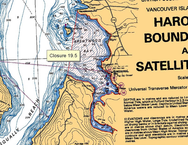
| 19.5 Brentwood Bay, Saanich Inlet | 19.5.jpeg | The waters and intertidal foreshore of Brentwood Bay, Saanich Inlet, lying inside a line drawn from Henderson Point at 48°35.89' north latitude and 123°28.79' west longitude to Willis Point at 48°34.65' north latitude and 123°29.13' west longitude. [NAD 27]. |
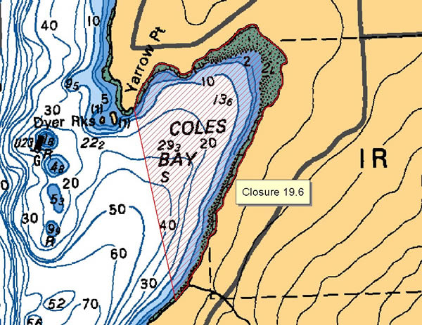
| 19.6 Coles Bay, Saanich Inlet | 19.6.jpeg | The waters and intertidal foreshore of Coles Bay, Saanich Inlet, lying inside a line drawn from Yarrow Point to a point on the eastern shore of the bay 125 m south of the unnamed creek entering at 8600 Kleewyck Road. [NAD83] |
| 19.7 Finlayson Arm, Saanich Inlet | 19.7.jpeg | The waters and intertidal foreshore of Finlayson Arm, Saanich Inlet, lying south of the power cables crossing the southern tip of Sawluctus Island. [NAD83] |
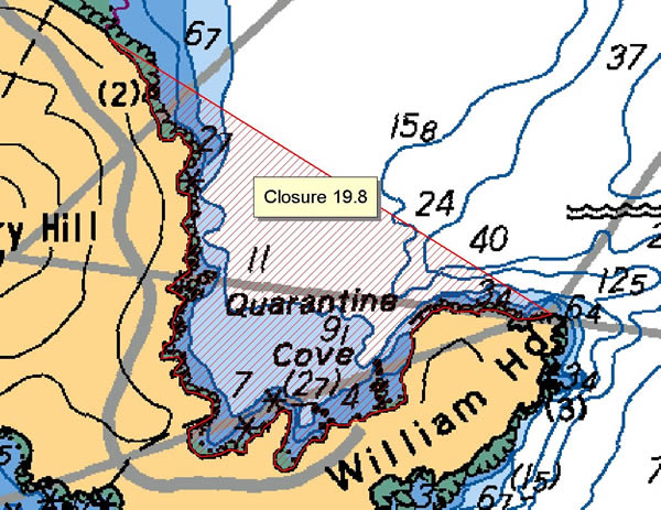
| 19.8 Quarantine Cove | 19.8.jpeg | The waters and intertidal foreshore of Quarantine Cove lying inside a line drawn from William Head to the southern end of Weir Beach. [NAD83] |
| 19.9 Cordova Spit to James Island to View Beach | 19.9.jpeg | The subtidal waters in Cordova Channel inside a line commencing at the east boundary of closure 19.2 near the end of Cordova Spit off Saanich Peninsula at 48°35.93' north latitude and 123°22.09' west longitude, thence easterly to the northern tip of the small islet on the southwest side of James Island at 48°35.91' north latitude and 123°21.30' west longitude, thence following the shoreline southeasterly to southern tip of the islet at 48°35.65' north latitude and 123°21.10' west longitude, thence southerly to the northern tip of a spit at the southwest side of James Island at 48°35.61' north latitude and 123°21.10' west longitude, thence following the shoreline southeasterly to the southwest tip of James Island at 48°35.42' north latitude and 123°20.90' west longitude, thence southwesterly to a point at the eastern boundary of closure 19.2 at 48°35.03' north latitude and 123°21.85' west longitude. [NAD83] |
| 19.ii Mill Bay Area | 19.ii.jpeg | In a portion of subarea 19-8, within the waters of Saanich Inlet inside a line that begins at 48°39.278’ N 123°32.401’ W then southeast to a point in water at 48°38.381’ N 123°31.767’ W then southwest to a point at 48°37.894’ N 123°31.777’ W then north following the shoreline to the beginning point. [NAD83] |
Last updated: 2024-04-01 06:20:57
| Area | Map | Area description |
|---|---|---|
| Cadboro Point | Those waters within 0.4 nautical miles of the Cadboro Point navigation light. | |
| Ogden Point | Ogden Point Breakwater; consisting of those waters inside a line from the navigation light at the western end of the causeway, thence to Brotchie Ledge Light, thence to Holland Point on Vancouver Island. | |
| Strait of Georgia Dive Closures (Area 19) | In the Victoria area, Ogden Point Breakwater, consisting of those waters inside a line from the navigation light at the western end of the causeway, thence to Brotchie Ledge Light, thence to Holland Point on Vancouver Island. | |
| Ten Mile Point | Those waters within 0.5 nautical miles of Ten Mile Point. |
Last updated: 2024-04-01 06:20:52
Crab
Crab
Species regulations
Always check for restrictions.
| Species | Areas | Min size | Gear | Limits (d/p/a) |
Status |
|---|---|---|---|---|---|
| Box and Puget Sound King crab | 19-1,19-3 to 19-12 | Dip Net, Hand Picking, Ring Net, Traps (Crab) | 1/2/- | Open (See Restrictions) | |
| 19-2 | -/-/- | Closed | |||
| Dungeness crab | 19-1,19-3 to 19-12 | 165mm | Dip Net, Hand Picking, Ring Net, Traps (Crab) | 4/8/- | Open (See Restrictions) |
| 19-2 | -/-/- | Closed | |||
| King crab | 19 | 0/0/0 | Closed | ||
| Other crab | 19-1,19-3 to 19-12 | Dip Net, Hand Picking, Ring Net, Traps (Crab) | 4/8/- | Open (See Restrictions) | |
| 19-2 | -/-/- | Closed | |||
| Red Rock crab | 19-1,19-3 to 19-12 | 115mm | Dip Net, Hand Picking, Ring Net, Traps (Crab) | 4/8/- | Open (See Restrictions) |
| 19-2 | -/-/- | Closed | |||
| Shore crab | 19-1,19-3 to 19-12 | Dip Net, Hand Picking, Ring Net, Traps (Crab) | 75/150/- | Open (See Restrictions) | |
| 19-1,19-3 to 19-12 | Hand Picking | 75/150/- | Open (See Restrictions) | ||
| 19-2 | -/-/- | Closed |
Last updated: 2024-04-01 06:12:56
Restrictions
Always check for protected areas.
| Species | Areas | Measure type | Measure value |
|---|---|---|---|
| Shellfish | 19-1 | Reminder | Victoria Harbour - Boating/fishing restrictions in Victoria Harbour. Please review important harbour and vessel navigation restrictions from Transport Canada at: https://tc.canada.ca/en/marine-transportation/ports-harbours-anchorages/port-victoria. Download their Port of Victoria Traffic Scheme diagram. Full text of vessel/navigation restrictions is shown at: https://tc.canada.ca/en/marine-transportation/ports-harbours-anchorages/practices-procedures-public-ports#220 Fishing, including the placement of traps, in navigational channels is prohibited; please exercise extreme caution in these areas while obeying Transport Canada navigational procedures. |
| 19-2 | Closed | As a precautionary measure, the May 10, 2016 closure of Esquimalt Harbour (Subarea 19-2) to all fishing due to a fuel spill continues. This closure was recommended by Island Health and will remain in place until testing can be done to determine that all species are safe for human consumption. | |
| 19-2,19-3 | Reminder | Esquimalt Harbour and approaches - Please review important harbour and vessel navigation restrictions, as depicted on Canadian Hydrographic Service Chart 3419. For more details link to: https://www.canada.ca/en/navy/corporate/esquimalt-harbour.html. Fishers are reminded to exercise caution while obeying navigational and use requirements in the harbour and vicinity. | |
| Strait of Georgia Dive Closures (Area 19) | Closed | These waters are closed to the harvest of all marine life by divers for the preservation of unique underwater habitat. | |
| Crab | Coastwide | Gear Restriction | Gear Permitted Maximum of 2 ring nets, dip nets or traps or combination of these per fisher. Ensure gear is properly marked. Hand picking is permitted including by diving. No sharp-pointed instruments are permitted for harvesting crab. It is illegal to use snares in catching or attempting to catch crabs. |
| Reminder | Keep navigation channels clear of buoys and lines. Any fishing gear that interferes with safe navigation can be removed under the Navigation Protection Act. | ||
| Crab | Coastwide | Gear Restriction | Crab traps are required to have two unobstructed circular escape holes or rings, measuring a minimum of 105 mm in diameter |
| Coastwide | Gear Restriction | Crab, Prawn and Shrimp Floats - The primary float attached to crab traps must be cylindrical in shape (includes bullet shaped) and a minimum of 27 cm in length and 12 cm in diameter; an optional secondary float may be used of any shape or size other than spherical. The primary float attached to prawn and shrimp traps must be spherical in shape and a minimum of 27 cm in diameter; an optional secondary float may be used of any shape or size other than cylindrical. Floats must be made of a durable material and suitable for operation in marine waters; floats/materials not suitable for use in marine waters are prohibited. | |
| Coastwide | Gear Restriction | Rot Cord - All crab traps must have a section in the top or sidewall that has been secured by a single length of untreated cotton twine no greater than No. 120 (approximately 5 mm or 3/16 inch diameter). This twine is often referred to as rot cord. On deterioration this must produce a rectangular opening with a minimum size of 7 cm x 20 cm, or a square opening with a minimum size of 11 cm x 11 cm. This regulation is intended to ensure that if the trap is lost, the section secured by the cord will rot, allowing captive crabs to escape, and preventing the trap from continuing to fish. On traps with a rigid frame and a freely opening hinged lid the trap lid must be secured by a single length of untreated cotton twine no greater than No. 120 so that the trap lid will open freely when the rot cord is broken. No other fastenings may impede the hinged lid of the trap from opening. | |
| 19 | Reminder | Combined daily limit for Dungeness crab, red rock crab, box crab, Puget Sound king crab and all other king crab is 4. | |
| 19 | Time of Day Restrictions | Daylight Hours - It is illegal to set or haul crab traps from one hour after sunset to one hour before sunrise; overnight soaking of traps is allowed. | |
| Esquimalt Harbour | Closed | Fuel spill - as a precautionary measure, Esquimalt Harbour (Subarea 19-2) is closed to all fishing (effective May 10, 2016 until further notice). | |
| Cadboro Point | Closed | ||
| Victoria Harbour | Dioxin Contamination (g/w) | Consumption of crab hepatopancreas should not exceed 135g/week Consumption of crab hepatopancreas harvested in those waters of Victoria Harbour north of a line from Macaulay Point to the navigation light at the western end of the Ogden Point breakwater to a line from Chapman Point southwesterly to the opposite shore should not exceed 135 g/week. | |
| Ten Mile Point | Closed | ||
| Ogden Point | Closed | ||
| King crab | Coastwide | Packaging and Transporting | In order to be accurately measured, the carapace of King crab that you catch must remain attached until the crab arrives at your residence or it is consumed. |
| Coastwide | Sex Restriction | As per the Conditions of Licence, it is prohibited to possess female King crab | |
| Crab, All species combined | Sidney/Cordova | Gear Restriction | Buoys - Use 27 cm diametre (or larger) brightly coloured buoys in Sidney and Cordova Channels, an area bounded on the south by a line from Cowichan Head to D"Arcy Shoals to the southernmost point of Sidney Island. The northern boundary extends from a point on the Saanich Peninsula shoreline due east to the light on the north end of James Island, east to northeasterly to the light on the U2 navigation buoy in Sidney Channel, then true east to Sidney Island. ?Larger buoys are being tested by both commercial and recreational crab fishers in these channels to improve visibility. |
| Dungeness crab | Coastwide | Packaging and Transporting | In order to be accurately measured, the carapace of Dungeness crab that you catch must remain attached until the crab arrives at your residence or it is consumed. |
| Sex Restriction | It is prohibited to possess female Dungeness crab | ||
| Red Rock crab | Coastwide | Packaging and Transporting | In order to be accurately measured, the carapace of Red Rock crab that you catch must remain attached until the crab arrives at your residence or it is consumed. |
| Sex Restriction | It is prohibited to possess female Red Rock crab |
Last updated: 2024-04-01 06:21:12
Area descriptions
| Area | Map | Area description |
|---|---|---|
| Cadboro Point | Those waters within 0.4 nautical miles of the Cadboro Point navigation light. | |
| Esquimalt Harbour | Subarea 19-2 | |
| Ogden Point | Ogden Point Breakwater; consisting of those waters inside a line from the navigation light at the western end of the causeway, thence to Brotchie Ledge Light, thence to Holland Point on Vancouver Island. | |
| Sidney/Cordova | Sidney/Cordova | |
| Strait of Georgia Dive Closures (Area 19) | In the Victoria area, Ogden Point Breakwater, consisting of those waters inside a line from the navigation light at the western end of the causeway, thence to Brotchie Ledge Light, thence to Holland Point on Vancouver Island. | |
| Ten Mile Point | Those waters within 0.5 nautical miles of Ten Mile Point. | |
| Victoria Harbour | Waters of Victoria Harbour north of a line from Macaulay Point to the navigation light at the western end of the Ogden Point breakwater to a line from Chapman Point southwesterly to the opposite shore |
Last updated: 2024-04-01 06:21:12
Other invertebrates
Other invertebrates
- Basic information about shellfish harvesting
- Seasonal recreational harvesting closures for prawn and shrimp
Species regulations
Always check for restrictions.
| Species | Areas | Gear | Limits (d/p/a) |
Status |
|---|---|---|---|---|
| Abalone | 19 | 0/0/0 | Closed | |
| Barnacles, Giant | 19-1,19-3 to 19-12 | Hand Picking | 6/12/- | Open (See Restrictions) |
| Barnacles, Goose | 19-1,19-3 to 19-12 | Hand Picking | 2kg/4kg/- | Open (See Restrictions) |
| Limpet | 19-1,19-3 to 19-12 | Hand Picking | 75/150/- | Open (See Restrictions) |
| Octopus | 19-1,19-3 to 19-12 | Diving, Hand Picking, Hook and Line, Traps (Crab) | 1/2/- | Open (See Restrictions) |
| Other shellfish species | 19-1,19-3 to 19-12 | 20/40/- | Open (See Restrictions) | |
| Sand Dollar | 19-1,19-3 to 19-12 | Hand Picking | 6/12/- | Open (See Restrictions) |
| Sea Cucumber | 19-1,19-3 to 19-12 | Diving, Hand Picking | 12/24/- | Open (See Restrictions) |
| Sea Urchin | 19-1,19-3 to 19-12 | Diving, Hand Picking | 12/24/- | Open (See Restrictions) |
| Shrimp, Ghost | 19-1,19-3 to 19-12 | Hand Digging, Hand Pump | 50/100/- | Open (See Restrictions) |
| Shrimp/Prawn | 19-1,19-3 to 19-12 | Ring Net, Spear, Trap (Other species of Shellfish) | 125/250/- | Open (See Restrictions) |
| 19-2 | Ring Net, Spear, Trap (Other species of Shellfish) | -/-/- | Closed | |
| Squid, All other species | 19-1,19-3 to 19-12 | Cast Net, Jigging | 20/40/- | Open (See Restrictions) |
| Squid, Opal | 19-1,19-3 to 19-12 | Cast Net, Jigging | 200/400/- | Open (See Restrictions) |
| Starfish sea star | 19-1,19-3 to 19-12 | Hand Picking | 6/12/- | Open (See Restrictions) |
Last updated: 2024-04-04 08:55:06
Restrictions
Always check for protected areas.
| Species | Areas | Measure type | Measure value |
|---|---|---|---|
| Shellfish | 19-1 | Reminder | Victoria Harbour - Boating/fishing restrictions in Victoria Harbour. Please review important harbour and vessel navigation restrictions from Transport Canada at: https://tc.canada.ca/en/marine-transportation/ports-harbours-anchorages/port-victoria. Download their Port of Victoria Traffic Scheme diagram. Full text of vessel/navigation restrictions is shown at: https://tc.canada.ca/en/marine-transportation/ports-harbours-anchorages/practices-procedures-public-ports#220 Fishing, including the placement of traps, in navigational channels is prohibited; please exercise extreme caution in these areas while obeying Transport Canada navigational procedures. |
| 19-2 | Closed | As a precautionary measure, the May 10, 2016 closure of Esquimalt Harbour (Subarea 19-2) to all fishing due to a fuel spill continues. This closure was recommended by Island Health and will remain in place until testing can be done to determine that all species are safe for human consumption. | |
| 19-2,19-3 | Reminder | Esquimalt Harbour and approaches - Please review important harbour and vessel navigation restrictions, as depicted on Canadian Hydrographic Service Chart 3419. For more details link to: https://www.canada.ca/en/navy/corporate/esquimalt-harbour.html. Fishers are reminded to exercise caution while obeying navigational and use requirements in the harbour and vicinity. | |
| Strait of Georgia Dive Closures (Area 19) | Closed | These waters are closed to the harvest of all marine life by divers for the preservation of unique underwater habitat. | |
| Other Invertebrates | 19-2 | Closed | As a precautionary measure, the May 10, 2016 closure of Esquimalt Harbour (Subarea 19-2) to all fishing due to a fuel spill continues. This closure was recommended by Island Health and will remain in place until testing can be done to determine that all species are safe for human consumption. Variation Order # PCH-2016-252 |
| Cadboro Point | Closed | ||
| Esquimalt Harbour | Closed | Fuel spill - as a precautionary measure, Esquimalt Harbour (Subarea 19-2) is closed to all fishing (effective May 10, 2016 until further notice). | |
| Ogden Point | Closed | ||
| Ten Mile Point | Closed | ||
| Octopus | Coastwide | Gear Restriction | The use of sharp pointed instruments or chemicals is prohibited. |
| Shrimp/Prawn | Coastwide | Gear Restriction | Traps must be marked with floating tag or buoy that has your name on it. This includes traps tied to a boat or dock or fished from shore. If two traps are attached to one ground-line, it is sufficient to attach a tag, float or buoy that bears the operator's name to one end of the ground-line. |
| Reminder | Combined daily limit for all shrimp species, including prawn, is 125 | ||
| Shrimp/Prawn | Coastwide | Reminder | Spot Prawns (Pandalus platyceros) with eggs: No person shall retain prawns carrying eggs, or remove eggs from the underside of prawns carrying eggs. All prawns carrying eggs externally on the underside of the tail shall be returned to the water immediately and in the manner that causes the least harm. |
| Coastwide | Gear Restriction | Maximum 4 traps or ring nets or combination of these per fisher. | |
| Coastwide | Gear Restriction | Crab, Prawn and Shrimp Floats - The primary float attached to crab traps must be cylindrical in shape (includes bullet shaped) and a minimum of 27 cm in length and 12 cm in diameter; an optional secondary float may be used of any shape or size other than spherical. The primary float attached to prawn and shrimp traps must be spherical in shape and a minimum of 27 cm in diameter; an optional secondary float may be used of any shape or size other than cylindrical. Floats must be made of a durable material and suitable for operation in marine waters; floats/materials not suitable for use in marine waters are prohibited. | |
| 19-7 to 19-12 | Season Planning | Pulse Fishing Closures - In Stuart Channel (17-5, 17-6, 17-9) Saanich Inlet (19-7 to 19-12) and Alberni Inlet (23-1 to 23-3), “pulse” fishing closures are in effect to increase prawn escapement and prawn abundance. Closed September 7 to September 15, October 1 to October 15, November 1 to November 15, December 1 to December 15. Closures from January to March, depending on results from fishery independent index surveys, will be announced through a fishery notice issued in late November or early December. Please see https://www.pac.dfo-mpo.gc.ca/fm-gp/rec/shellfish-coquillages-eng.html#prawn and the fishery notice for more information. |
Last updated: 2024-04-04 08:55:11
Area descriptions
| Area | Map | Area description |
|---|---|---|
| Cadboro Point | Those waters within 0.4 nautical miles of the Cadboro Point navigation light. | |
| Esquimalt Harbour | Subarea 19-2 | |
| Ogden Point | Ogden Point Breakwater; consisting of those waters inside a line from the navigation light at the western end of the causeway, thence to Brotchie Ledge Light, thence to Holland Point on Vancouver Island. | |
| Strait of Georgia Dive Closures (Area 19) | In the Victoria area, Ogden Point Breakwater, consisting of those waters inside a line from the navigation light at the western end of the causeway, thence to Brotchie Ledge Light, thence to Holland Point on Vancouver Island. | |
| Ten Mile Point | Those waters within 0.5 nautical miles of Ten Mile Point. |
Last updated: 2024-04-04 08:55:11
Protected areas
Protected areas
Learn about permanent restrictions that are in effect:
| Area | Type | Closure name |
|---|---|---|
| 19 | Area of Interest | Race Rocks Area of Interest |
| 19-3 | Rockfish Conservation Area | Duntze Head (Royal Roads) |
| Race Rocks | ||
| Trial Island | ||
| 19-4 | Rockfish Conservation Area | D'Arcy Island to Beaumont Shoal |
| Discovery - Chatham Islands | ||
| Trial Island | ||
| 19-5 | Rockfish Conservation Area | Brethour, Domville, Forrest, Gooch Islands |
| Coal Island | ||
| D'Arcy Island to Beaumont Shoal | ||
| 19-8 | Rockfish Conservation Area | Brentwood Bay |
| 19-11 | Rockfish Conservation Area | Mid Finlayson Arm |
Last updated: 2022-08-05 15:24:53
Area descriptions
| Area | Map | Area description |
|---|---|---|
| Brentwood Bay | Brentwood_Bay.png | Those waters of Subarea 19-8 that lie inside a line that: begins at 48°34.788'N 123°28.220'W Sluggett Point then to 48°34.647'N 123°29.222'W Willis Point then to 48°35.300'N 123°29.500'W in water then to 48°35.900'N 123°29.500'W in water then to 48°35.877'N 123°28.852'W Henderson Point then southerly following the shoreline to the beginning point. |
| Brethour, Domville, Forrest, Gooch Islands | Brethour,_Domville,_Forrest,_Gooch_Islands.png | Those waters of Subareas 18-6 and 19-5 that lie inside a line that: begins at 48°41.650'N 123°19.978'W Imrie Island then to 48°41.088'N 123°17.622'W Arachne Reef Light then following the boundary line between Subarea 18-6 and 19-5 to the intersection with the International Boundary between the United States and Canada, then following the International Boundary in a southerly direction to the intersection with the parallel passing through 48°39.800' north latitude, then to 48°39.738'N 123°16.551'W Tom Point then to 48°38.989'N 123°18.081'W South Cod Reef Buoy then to 48°39.400'N 123°19.645'W Forrest Island then following the northerly shoreline of Forrest Island to 48°39.963'N 123°20.467'W Forrest Island then to 48°40.865'N 123°20.410'W Greig Island Daybeacon then to the beginning point. |
| Coal Island | Coal_Island.png | Those waters of Subareas 18-6 and 19-5 that lie inside a line that: begins at 48°41.278'N 123°24.124'W Swartz Head then to 48°41.474'N 123°23.289'W Fir Cone Point Light then following the westerly shoreline of Coal Island to 48°40.753'N 123°22.626'W west of Kamai Point then to 48°40.232'N 123°22.669'W Little Shell Island then to 48°40.047'N 123°23.859'W Armstrong Point then westerly following the shoreline to 48°40.179'N 123°24.273'W Tsehum Harbour Breakwater then to 48°40.478'N 123°23.804'W Curteis Point then northerly following the shoreline to the beginning point. |
| D'Arcy Island to Beaumont Shoal | D'Arcy_Island_to_Beaumont_Shoal.png | Those waters of Subareas 19-4 and 19-5 that lie inside a line that: begins at 48°34.271'N 123°16.687'W D'Arcy Island then to 48°34.325'N 123°16.157'W Little D'Arcy Island then true east to the intersection with the International Boundary between the United States and Canada, then southerly following the International Boundary to the intersection with the parallel passing through 48°24.400' north latitude, then to 48°26.800'N 123°11.500'W in water then to 48°32.400'N 123°14.900'W in water then to 48°32.400'N 123°17.100'W in water then to 48°33.922'N 123°17.100'W D'Arcy Island Light then following the southerly shore of D'Arcy Island to the beginning point. |
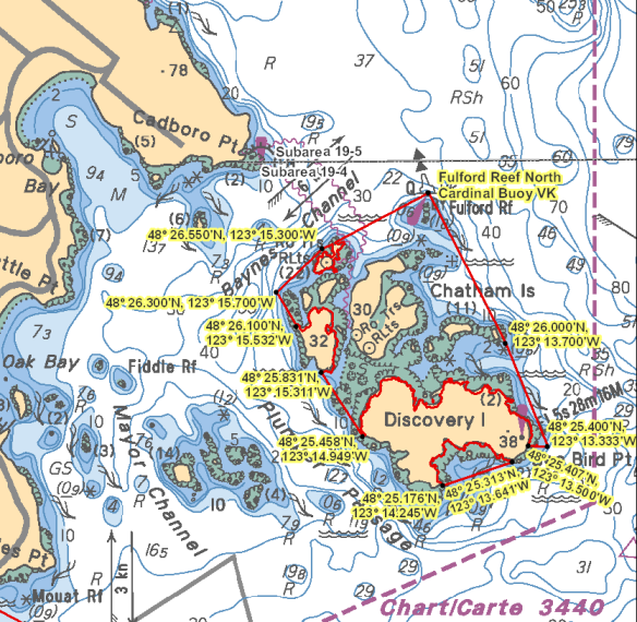
| Discovery - Chatham Islands | Discovery-Chatham_Islands.png | Those waters of Subarea 19-4 that lie inside a line that: begins at 48°26.875'N 123°14.378'W Fulford Reef North Cardinal Buoy VK then to 48°26.000'N 123°13.700'W in water then to 48°25.400'N 123°13.333'W in water then to 48°25.407'N 123°13.500'W Sea Bird Point then westerly following the northerly shoreline of Discovery Island to 48°25.458'N 123°14.949'W Discovery Island then to 48°25.831'N 123°15.311'W Chatham Islands then to 48°26.100'N 123°15.532'W Chatham Islands then to 48°26.300'N 123°15.700'W Channel Point then to 48°26.550'N 123°15.300'W in water then to the beginning point; and those waters of Rudlin Bay that lie northerly of a line: from 48°25.176'N 123°14.245'W Commodore Point to 48°25.313'N 123°13.641'W Discovery Island |
| Duntze Head (Royal Roads) | Duntze_Head_(Royal_Roads).png | Those waters of Subarea 19-3 that lie inside or shoreward of a line that: begins at 48°25.854'N 123°26.375'W Duntze Head then to 48°25.550'N 123°26.500'W in water then to 48°25.150'N 123°25.400'W in water then to 48°25.311'N 123°25.208'W Saxe Point |
| Mid Finlayson Arm | Mid_Finlayson_Arm.png | Those waters of Subarea 19-11 that lie inside a line that: begins at 48°30.900'N 123°32.145'W east of Christmas Point then true west to 48°30.900'N 123°32.400'W in water then to 48°31.400'N 123°32.400'W in water then to 48°32.000'N 123°32.750'W in water then to 48°32.800'N 123°32.900'W in water then true east to Elbow Point, then following the shoreline in a southerly direction to the beginning point. |
| Race Rocks | Race_Rocks.png | Those waters of Subareas 19-3 and 20-5 that lie inside the 40 metre contour line surrounding Great Race Rock and Rosedale Rock as shown on Chart No. 3461, published by the Canadian Hydrographic Service of the Department. |
| Trial Island | Trial_Island.png | Those waters of Subareas 19-3 and 19-4 that lie inside a line that: begins at 48°24.600'N 123°18.533'W in water then to 48°24.370'N 123°17.900'W in water then to 48°23.800'N 123°18.050'W in water then true west to 48°23.800'N 123°18.600'W in water then to the beginning point. |
.png)
Last updated: 2022-08-05 15:24:53
- Date modified: