
Long term trends in deep water properties of BC inlets
Archived Content:
Information identified as archived on the Web is for reference, research or recordkeeping purposes. It has not been altered or updated after the date of archiving. Web pages that are archived on the Web are not subject to the Government of Canada Web Standards. As per the Communications Policy of the Government of Canada, you can request alternate formats on the "Contact Us" page.
The deep waters of inlets, i.e. those waters trapped behind the inlet's sill, are usually quiescent. Isolated from the annual and higher frequency variations present in the near surface waters, the deep waters provide a good sampling location for observing the long term changes in water properties (temperature, salinity and dissolved oxygen). The deep waters chronicle the temperature, salinity and dissolved oxygen properties of the outside waters.
The almost 50 year long time series of water properties from some inlets, more than 60 years in the case of Saanich Inlet, are potentially rich sources of information about our coastal environment and how it has changed in the last half century. This web site presents the time series of deep water properties from the better sampled inlets (Saanich Inlet, Indian Arm, Howe Sound, Jervis Inlet, Bute Inlet, Knight Inlet and Muchalat Inlet). The web site also provides basic physical, hydrologic and oceanographic information for the better sampled inlets.
Background
Dr. George Pickard of the Institute of Oceanography at the University of British Columbia (UBC) initiated in 1951, and conducted for many years, a series of inlet cruises. The inlet cruises, conducted mostly in the summer, were used for studies of the BC fjords and also served as training exercises for oceanography students. Students obtained and analyzed water samples for temperature, salinity and dissolved oxygen in many fjords, straits, passages and channels on the entire BC coast. The data set is a remarkably long (~ 50 years), high quality time series that spans the entire length of the mainland coast and Vancouver Island.
Several other researchers, notably Drs. John Tully and Mike Waldichuk, also conducted sampling programs in several BC inlets. Dr. Tully's work extends back to the 1930's, and Dr. Waldichuk conducted several pollution cruises in the 60's and 70's to inlets where there were pulp mills. In the last 25 years, the fjord research at Institute of Ocean Sciences (IOS) has provided extensive sets of observations from several fjords, in particular Knight, Saanich and Alberni Inlets. All of the IOS data sets and most, but not all, of the early inlet and coastal water surveys are now preserved in digital form in the IOS data archive.
Sampling statistics
One of the first steps in the construction of the time series of deep water properties was to determine which inlets had been sampled most consistently and most often - the sampling statistics for the BC inlets. The IOS electronic data archive was searched for all data holdings in the geographical area corresponding to the major inlets of the BC coast. In some cases smaller but significant inlet areas were also searched. The data holdings from individual inlets were then summarized by time in the form of sampling histograms depicting the length of the time series and number of samples per year. The table below summarizes the sampling statistics for the best sampled inlets, and the diagram that follows depicts geographically the sampling statistics in terms of total number of stations or profiles taken in the different inlets.
Regional descriptions
Georgia Basin inlets (Saanich, Indian Arm, Howe Sound, Jervis, Bute)
- the best sampled inlets of the BC coast
West Coast Vancouver Island Inlets (Alberni, Muchalat, Neroutsos and Rupert-Holberg)
- the inlets of this coast have fragmented times series with long gaps
- in Alberni Inlet, the deep waters have a significant annual signal which obscures long term trends
Central and North Coast inlets (Knight, Douglas - Kitimat, and Observatory)
- with the exception of Knight Inlet, sampling is very sparse
- an appreciable annual signal in the deep waters of Knight inlet may obscure long term trends
- Observatory Inlet and Alice Arm have large number of samples but almost all were takenin a 3 year period
Haida Gwaii
- sampling is very sparse
Table of sampling statistics for the better sampled inlets
| Inlet | Number of stations | Length of time series (years) | Comments | Histogram |
|---|---|---|---|---|
| Saanich Inlet | 1560 | 47 | 3 year gap in late 50's, earliest measurements in 1930 |  |
| Jervis Inlet | 1000 | 49 | 1 and 2 year gap | 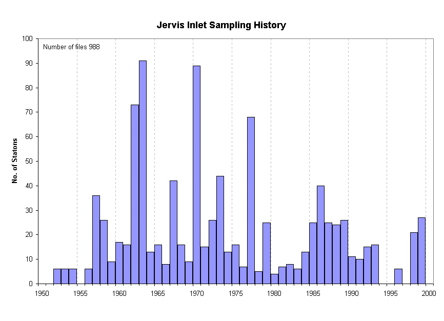 |
| Indian Arm | 1350 | 45 | 4 year gap from 1964-67 |  |
| Howe Sound | 860 | 48 | Several 1 or 2 year gaps, half of stations inside sill |  |
| Bute Inlet | 750 | 50 | Many 2 and 3 year gaps in the 80's and 90's |  |
| Knight Inlet | 1260 | 50 | Some 1, 2 and 3 year gaps |  |
| Muchalat Inet | 250 | 42 | Many gaps, one gap is 5 years in length, earliest measurement in 1933 | 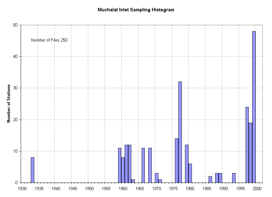 |
| Alberni Inlet | 1540 | 31 | Several 1, 2 and 3 year gaps, two main basins, earliest measurements in 1937 | 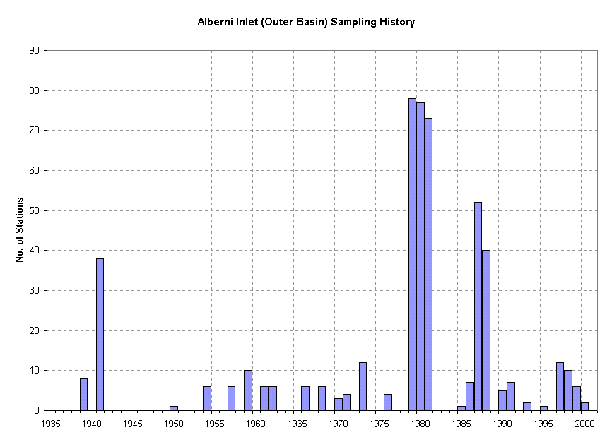 |
| Portland and Observatory Inlets and Alice Arm | 2200 | 20 | Almost all samples taken in 3 year period from 1981-1983, many gaps |
Map of sampling statistics for individual inlets

Related links
- Date modified: