
Fieldnotes Pacific Science Field Operations: 2025 - 2026

Description: Fieldnotes Pacific science field operations: 2025 to 2026
Ullukkut, hadi’, yaù, k̓alhwá7alap, ʔéx kʷ n̓, weyt-kp, ÍY SȻÁĆEL, híy̓áu, hello!
Have you heard?
Our annual compendium of planned field research and monitoring in the Northeast Pacific and Arctic oceans, and in the coastal and inland waters of British Columbia and Yukon, is now available!
Fieldnotes is our contribution to continuous improvement, stronger relationships, and to doing better together.
New web map features!
Following the release of our interactive web map last spring, we’ve made functional improvements to the 2025-26 edition of Fieldnotes. Users can now access these additional functions:
- Find field operations by drawing an area of interest in the select widget (top-right image)
- Browse or search the list panel, featuring an at-a-glance view of all field operation titles
- Share a URL link directly to the selected field operations from your map
- Export selected table rows to Excel
Enjoy your Fieldnotes explorations!
Scan QR code to visit the updated Fieldnotes map
Example view of the updated interactive Fieldnotes map demonstrating the new select widget, with the circle shape enabled.
Timeline
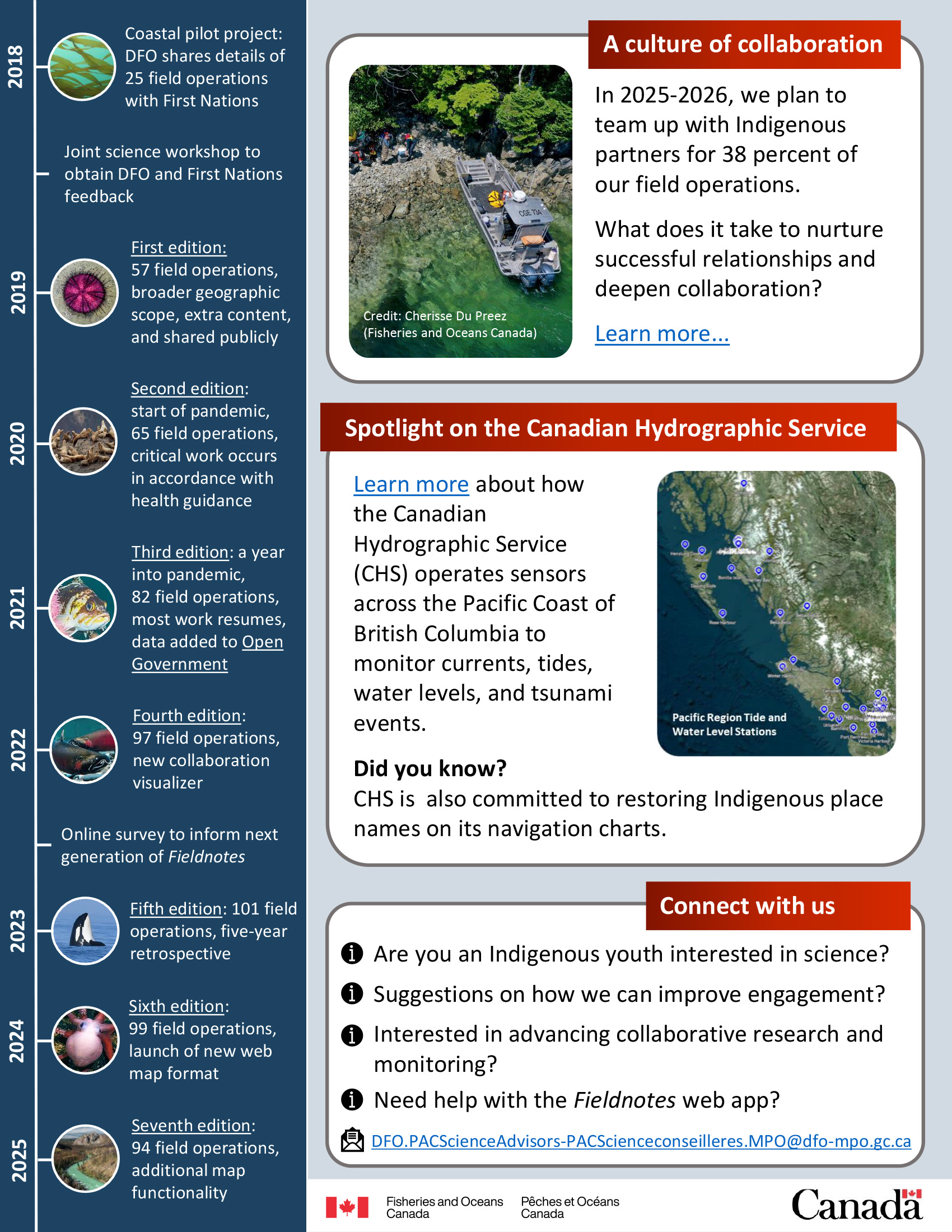
2018
- Coastal pilot project: DFO shares details of 25 field operations with First Nations
- Joint science workshop to obtain DFO and First Nations feedback
2019
- First edition: 57 field operations, broader geographic scope, extra content, and shared publicly
2020
- Second edition: start of pandemic, 65 field operations, critical work occurs in accordance with health guidance
2021
- Third edition: year into pandemic, 82 field operations, most work resumes, data added to Open Government
2022
- Fourth edition: 97 field operations, new collaboration visualizer
- Online survey to inform next generation of Fieldnotes
2023
- Fifth edition: 101 field operations, five-year retrospective
2024
- Sixth edition: 99 field operations, launch of new web map format
2025
- Seventh edition: 94 field operations, additional map functionality
A culture of collaboration
In 2025-2026, we plan to team up with Indigenous partners for 38 percent of our field operations.
What does it take to nurture successful relationships and deepen collaboration?
Spotlight on the Canadian Hydrographic Service
Learn more about how the Canadian Hydrographic Service (CHS) operates sensors across the Pacific Coast of British Columbia to monitor currents, tides, water levels, and tsunami events.
Did you know?
CHS is also committed to restoring Indigenous place names on its navigation charts.
Connect with us
- Are you an Indigenous youth interested in science?
- Suggestions on how we can improve engagement?
- Interested in advancing collaborative research and monitoring?
- Need help with the Fieldnotes web app?
Email: DFO.PACScienceAdvisors-PACScienceconseilleres.MPO@dfo-mpo.gc.ca
- Date modified: