
Integrated geoduck management framework - 2017
This Framework provides policy guidance for the integrated management of both wild and aquaculture geoduck fisheries in British Columbia.
This document is for guidance purposes only and does not fetter the Minister's discretionary powers as set out in the Fisheries Act. The Minister can, for reasons of conservation or for any other valid reasons, modify any provision of this document in accordance with the powers granted pursuant to the Fisheries Act. In the event of an inconsistency between the Framework and the Fisheries Act or its Regulations, the legislation will prevail.
Table of contents
- Introduction
- Principles and objectives
- Background
- Framework application
- Coastwide opportunities for geoduck aquaculture
- Siting guideline
- Management issues and objectives: geoduck aquaculture
- Access to broodstock
- Map reserves
- Framework review
- Definitions
- References
- Geoduck hatchery protocol
- Protocol for commercial harvest prior to aquaculture licensing
- Harmonized process for the shellfish and finfish aquaculture sectors
- Integrated geoduck management framework maps
1. Introduction
Fisheries and Oceans Canada (DFO) has the lead federal role in managing Canada's fisheries and safeguarding its waters. In British Columbia (BC), this includes the primary regulatory responsibility for managing both wild and aquaculture fisheries, including geoduck (Panope generosa). Consistent with this mandate, DFO is committed to supporting conservation and long-term sustainability of wild stocks and fisheries, as well as economic growth in Canada`s marine and fisheries sectors.
Since the 1970`s, the wild geoduck fishery has grown into one of the most economically prosperous and environmentally sustainable fisheries on the West Coast. More recently, since the mid-1990`s, both government and industry have taken a number of steps toward the development of a viable geoduck aquaculture industry in BC.
The management of geoduck is complex given the nature of the fisheries and the geographic, biological and environmental conditions required for geoduck to grow and support viable fisheries. Geoduck aquaculture represents an opportunity to diversify the economy of coastal and Aboriginal communities in BC. At the same time, DFO recognizes the importance of ensuring the conservation of wild geoduck stocks, as well as the economic prosperity and long-term sustainability of the wild geoduck fishery.
This document and the approaches outlined within it are designed to provide a management framework under which both wild and aquaculture fisheries for geoduck can thrive. In that context, the document provides guidance on 4 key areas:
- Coastwide opportunities for geoduck aquaculture;
- Siting guideline for shellfish aquaculture, aimed at minimizing overlap with the existing commercial fishery while providing sustainable opportunities for aquaculture;
- Wild harvest opportunities prior to aquaculture licensing; and
- An overview of management issues and approaches related to geoduck aquaculture.
2. Principles and objectives
The following section outlines the principles and objectives that will guide DFO in the integrated management of wild and aquaculture fisheries for geoduck.
2.1. Principles
The Department will be guided by the following principles:
- Conservation – The conservation and long-term sustainability of wild geoduck stocks is the first priority.
- Obligations to First Nations – DFO will respect constitutionally protected Aboriginal and treaty rights and will work to engage interested and affected First Nations in the management of commercial geoduck fisheries and geoduck aquaculture.
- Economic Prosperity and Sustainable Use – DFO will support economic opportunities and the sustainable use of both wild and aquaculture fisheries.
- Transparency – This Framework will support open and transparent decision-making related to the management of commercial geoduck fisheries and geoduck aquaculture.
2.2. Objectives
The following objectives will support the integrated management of wild and aquaculture fisheries for geoduck:
- Support economically, environmentally and socially sustainable wild and aquaculture fisheries.
- Identify coastwide opportunities for geoduck aquaculture
- Manage the overlap between wild and aquaculture fisheries.
- Establish transparent siting criteria and procedures for geoduck aquaculture.
3. Background
3.1. Wild commercial geoduck harvest in BC
The commercial dive fishery for geoduck in BC began in 1976. The fishery expanded rapidly until 1979 when licence numbers were capped and harvest quotas were set for conservation purposes. In 1989, with the support of the commercial industry, a management program with individual vessel quotas (IVQ) for geoducks was initiated. As part of this initiative, area licensing and a three-year area rotation period for the fishery was established. Geoduck licence quotas were set at 1/55 of the annual commercial Total Allowable Catch (TAC). There are 55 commercial licences, generally fished on about 40 vessels. In 2012 a pilot program was initiated where the quota for each licence was divided into 10 tradable blocks.
Currently, the TAC and the IVQ's are based on a low annual harvest rate (1.2% - 1.8%) of the estimated current biomass and the fishing effort is distributed and managed on a bed-by-bed basis. The commercial fishery occurs coastwide in units called Geoduck Management Areas (GMAs). GMAs are defined portions of Pacific fisheries waters built on the areas and subareas as defined in the Pacific Fishery Management Area Regulations. GMAs scheduled to be fished, in any given year, are assigned a quota. The fishery may open and close based on sanitary and biotoxin contamination conditions as well as market demand. The schedule of openings and closures varies from year to year, but is planned to allow for a year-round supply of geoducks to reach the market.
Geoducks are harvested commercially by divers using high pressure water delivered through a nozzle (known as a "stinger") to loosen the substrate around the clam and allow the clam to be lifted out alive.
The current management plan for the geoduck fishery has established limit reference points as required under the precautionary approach and the Department's Sustainable Fisheries Framework (SFF). Geoduck beds are closed for harvest if the biomass on the bed is below this reference point. These closed beds are not considered for re-opening until a survey has been conducted that demonstrates that the biomass has recovered and is above the limit reference point.
The wild commercial geoduck fishery harvest is monitored using on-grounds monitors and 100% of the harvest is independently validated, dockside, at the first point of landing. Geoduck that arrive at fish plants must be accompanied by a tag upon which the vessel name, vessel registration number (VRN), "G" or "FG" tab number, and the date and location of harvest are recorded.
More information regarding the management of geoduck fisheries can be found in the Integrated Fisheries Management Plan
3.2. Geoduck aquaculture in BC
Geoduck aquaculture has taken place in BC since the early 1990's. In that time, interest in geoduck aquaculture has continued to grow and significant investments have been made by industry and government in terms of research, cultivation techniques, hatchery production, and economic and technical feasibility.
Geoduck typically take 7 to 10 years to mature from planting to harvest. Given the long maturation time, geoduck aquaculture operations require a significant investment in terms of capital, planning and management before operators see any return on investment. In BC, the majority of interest has focused on sub-tidal aquaculture. However, a number of intertidal sites also exist and some experimentation with cultivation in suspended aquaculture systems has occurred. Inter-tidal aquaculture has proven successful in other jurisdictions such as Puget Sound in Washington State.
As with other types of shellfish aquaculture, viable geoduck aquaculture depends on the production and access to seed. Typically, broodstock is selected and conditioned in a hatchery for a year or more prior to spawning. Juvenile geoduck are then reared in a nursery system until reaching a suitable size for out-planting. Juvenile geoduck require a sand substrate, making nursery rearing challenging. Different techniques have been employed by producers in BC and elsewhere to provide a suitable nursery environment.
When the geoduck have grown to approximately 10 mm, they are transferred to grow-out beds (either low inter-tidal or sub-tidal) where they are planted in the substrate. The planted geoduck take time to bury themselves into the substrate which can leave them subject to predation from crabs and starfish. Predator protection measures are often employed to reduce losses. In inter-tidal systems, geoduck are planted directly into PVC tubes which have been pushed into the substrate and covered with mesh, the mesh and tube are later removed. Common practice in sub-tidal environments involves the use of mesh "canopies" secured to the substrate covering the areas planted with geoduck during early growth stages. These predator control measures may be in place for 18 months to two years.
Current harvesting methods for both inter-tidal and sub-tidal culture involves the use of a "wand" or "stinger" which is inserted into the sea bed around the Geoduck and liquefies the sand using high pressure water. The geoduck can then be gently removed by grasping the siphon. This harvesting method is the same as that used in the commercial geoduck fishery.
In 1997, the Province of BC established a temporary moratorium on new geoduck aquaculture sites which lasted approximately 8 years.
From 2004 through 2006, DFO and the Province of BC worked together in developing a series of three interim policies to guide the management of geoduck aquaculture. These policies included a "phased approach" to geoduck aquaculture with an initial focus on the Strait of Georgia and the pre-selection of new areas available for geoduck aquaculture. As a result of these policies, 6 new sites, all within the Strait of Georgia, were identified and licensed by the Province of BC.
On December 19, 2010, DFO assumed the primary responsibility for regulating and managing most aspects of aquaculture in BC. The Pacific Aquaculture Regulations (PAR) were developed to outline the Department's authorities with respect to the management of the industry. New aquaculture licences were issued for existing shellfish, finfish and freshwater/land-based aquaculture operations in BC, including those geoduck aquaculture sites previously licensed by the Provincial government.
Through the PAR and British Columbia Aquaculture Regulatory Program (BCARP), DFO has developed a robust regulatory and management framework for aquaculture in BC. The Department is working closely with the Province, Transport Canada and other partners to ensure that aquaculture is sustainable and managed in a way that supports DFO's mandate for conservation and sustainable use of aquatic resources.
More information regarding DFO's management of aquaculture in BC
3.3. Role of Canadian federal government
The Minister of Fisheries and Oceans, through the powers granted under the Fisheries Act and its Regulations, has the authority to manage and regulate fisheries including wild commercial geoduck harvest, geoduck aquaculture, recreational geoduck harvest and First Nations harvest of geoduck for food, social and ceremonial purposes.
Under the Minister's authority for the proper management and control of fisheries and the conservation and protection of fish, DFO develops policies and management plans, issues licences, establishes conditions of licence and enforces those conditions as appropriate
DFO, along with Environment and Climate Change Canada (ECCC) and the Canadian Food Inspection Agency (CFIA), is responsible for delivering the Canadian Shellfish Sanitation Program (CSSP). The goal of the program is to protect Canadians from the health risks associated with the consumption of contaminated bivalve shellfish (e.g. mussels, oysters and clams). See 6.2.4 for more details.
Transport Canada is responsible for minimizing the impact of works on navigable waterways.
3.4. Role of BC
The Province of British Columbia (BC), through the Ministry of Forests, Lands and Natural Resource Operations (FLNRO), is responsible for land-use allocation decisions and provides tenure rights to Provincial Crown land, foreshore and aquatic Provincial Crown land under authority of the BC Land Act. Under the Provincial Aquaculture Land Use Policy, tenures are provided for the cultivation of finfish, shellfish and marine plants on aquatic Provincial Crown land or foreshore.
3.5. Role of First Nations
First Nations have a particular historic and cultural interest in the harvest and management of aquatic resources near their communities. As part of the review process of aquaculture proposals, DFO consults with local First Nations, and seeks their input and views on the proposal in advance of the issuance of any aquaculture licenses or leases.
3.6. Role of local governments
Municipal governments or regional districts may require specific zoning be in place prior to the commencement of any aquaculture operations.
3.7. Federal/provincial cooperation
In recognition of their respective roles, DFO, the Province of BC and Transport Canada (TC) have developed a harmonized aquaculture application and review process. This process includes a single harmonized application for new aquaculture licence and tenure applications, as well as amendments to existing licences. The three agencies have also established a harmonized process for the review and consideration of new and amended aquaculture applications. While each federal and provincial agency retains its respective decision-making authority, this process is designed to support more effective communication and coordination with respect to the review and potential issuance of their respective authorizations for aquaculture in BC. (see Appendix 3 for details)
4. Framework application
4.1. Application
This Framework applies to the management of wild and aquaculture geoduck commercial fisheries in BC. It applies to applications for new and/or amended shellfish aquaculture licences, including geoduck hatcheries. In doing so, it replaces the following interim policies:
- Information Regarding the Amendment of an Existing Intertidal Shellfish Licence to Include Geoduck Aquaculture, 2005'
- 'Information Regarding the Amendment of an Existing Subtidal Shellfish Licence to Include Geoduck Aquaculture, 2005'
- 'Information Regarding Making Application for a New Subtidal Geoduck Aquaculture Tenure and Licence, 2005'
- 'Interim Protocol for Pre-seed Harvest of Sub-tidal Geoduck Aquaculture Sites , 2010'
5. Coastwide opportunities for geoduck aquaculture
Since 2006, DFO and the Province of BC have taken a phased approach to the expansion of geoduck aquaculture, with an initial focus on the Strait of Georgia. This approach was based on science advice that identified uncertainties regarding potential genetic and disease impacts of geoduck aquaculture on wild populations. Phased expansion was meant to minimize potential risks associated with geoduck aquaculture pending further science work, as well as the development of additional management and regulatory measures. As a result, since 2006, new opportunities for geoduck aquaculture have been limited to the Strait of Georgia.
In that time, interest in geoduck aquaculture has continued to increase, as has our understanding of potential risks related to interactions between wild and farmed geoduck populations. The Department has undertaken further science work to assess these risks (Bureau et al, 2013). Bureau et al explored potential risks and mitigation measures related to geoduck aquaculture and made a number of recommendations related to the source and volume of geoduck broodstock, transfer zones and quarantine practices.
DFO has determined that potential disease, genetic and ecological risks associated with the expansion of geoduck aquaculture beyond the Strait of Georgia can be adequately addressed through implementation of new management measures, including hatchery protocols, conditions of licence and the Introductions and Transfers process.
In establishing the Integrated Geoduck Management Framework, DFO will now consider aquaculture applications on a coastwide basis (beyond the Strait of Georgia). The Department will consider both new applications for geoduck aquaculture, and applications to add geoduck to existing aquaculture operations, in all areas of the Pacific coast, subject to the normal review process for shellfish aquaculture applications and the siting guidelines outlined below.
A revised Geoduck Hatchery Protocol has been developed (see Appendix 1) and will be implemented through DFO conditions of licence for each hatchery.
6. Siting guidelines
6.1. Context
The siting guidelines are intended to identify those areas available for new shellfish aquaculture applications, while managing overlap with the existing commercial geoduck fishery. Regardless of the area applied for, all applications are subject to the review by applicable Federal and Provincial agencies as part of the harmonized aquaculture review process.
The siting guidelines are grounded in historical information regarding the wild commercial geoduck harvest over the last 4 fishing opportunities, prior to 2014, in sub-tidal waters. This information has been used to identify those areas used most extensively by the wild commercial fishery.
The siting guidelines apply to:
- Applications for new shellfish applications in sub-tidal or intertidal areas.
- Applications for size increases of existing shellfish aquaculture operations.
The siting guideline do not apply to applications for amendments to existing licences for the purpose of shellfish aquaculture where the area is already tenured and licensed for aquaculture and there are no proposed changes to the boundary of the tenure area.
6.2. Shellfish aquaculture siting matrix
The Shellfish Aquaculture Siting Matrix (the Matrix) is a visual representation of the siting guideline (Fig. 1) and illustrates the key differences between the categories so that applicants can understand what areas are available for shellfish aquaculture applications. Further information regarding each of these areas, and the corresponding review considerations, are outlined below.
In order to assist shellfish aquaculture licence applicants with interpreting the Siting Matrix, a series of maps have been developed that geographically represent the Yellow and Red areas.
The classification of areas reflected in these maps will remain in effect for 10 years from the implementation date of this Framework.
| Category | Yellow Shellfish aquaculture applications accepted |
Red Shellfish aquaculture applications generally not accepted - See exception in 6.2.2 |
|---|---|---|
| Criteria for Determining Category | Some geoduck commercial landing history (1 – 3 times in the last 4 fishing opportunities) | Geoduck harvested in each of the last 4 fishing opportunities |
| Review Considerations | Review will include a detailed assessment of the potential impacts to the geoduck fishery | For exception situations only, review will follow Yellow area approach Otherwise does not apply |
| Commercial Harvest Opportunity Prior to Aquaculture Licensing | One commercial harvest opportunity: 3 months in 6 months PSP free window | For exception situations only, review will follow Yellow area approach Otherwise does not apply |
Figure 1. Shellfish Aquaculture Siting Matrix for new shellfish aquaculture applications or expansion to existing shellfish aquaculture operations.
6.2.1. Yellow areas
Yellow areas are defined as areas of the coast that have been harvested by the wild commercial geoduck fishery 1 to 3 times out of the previous 4 times the area has been available to be harvested.
DFO will consider applications for shellfish aquaculture in these areas. In addition to the regular review process for shellfish aquaculture, the Department will also consider the extent of potential impacts on the wild commercial geoduck fishery.
Applications in Yellow areas will be considered for aquaculture operations up to 20 hectares.
Successful applications in Yellow areas will be subject to a harvest of wild geoduck from the site by the wild commercial fishery in advance of aquaculture licensing. See Section 6.3 for details.
6.2.2. Red areas
Red areas are those areas of the coast that have been harvested by the wild commercial geoduck fishery 4 times out of the previous 4 times the area has been available to be harvested.Footnote 1
Generally, DFO will not consider applications for shellfish aquaculture in red areas.
Under special circumstances, DFO will consider applications for shellfish aquaculture in red areas submitted by a First Nation. Consideration will be given to applications by First Nations, supported by a band council resolution, that have reserve land adjacent to the red area being applied for. In these cases, a single application may be considered up to a maximum size of 10 hectares. These licences would be considered for issuance only to First Nations and will be non-transferable. These licences would also be subject to a commercial harvest prior to aquaculture licensing as outlined in Section 6.3.
Additional opportunities for First Nations geoduck aquaculture in red areas beyond 10 ha, in some cases, may also be considered in areas immediately adjacent to their reserves (or proposed Treaty Settlement Lands) as an economic opportunity within broader treaty, incremental treaty or non-treaty agreement negotiations with Canada. To balance the impact of such opportunities on the wild geoduck fishery, any such opportunity must be mitigated through the relinquishment of an appropriate amount of commercial geoduck quota.
Provision of aquaculture access by First Nations to red areas supports the Government of Canada's broad policy objective to provide economic development opportunities to First Nations. This access does not, and is not intended to, define or extinguish any Aboriginal or treaty rights, neither is it evidence of the nature or extent of any Aboriginal or treaty right.
6.2.3. Other areas
Most areas of the coast have no recent documented harvest by the wild commercial geoduck fishery as of 2016.
DFO will consider applications for shellfish aquaculture in these areas, including intertidal areas.
Licence applications of all sizes will be considered in these areas, but the size of the proposed aquaculture operation will be reviewed in the context of other land and water use activities in the vicinity prior to any licence issuance.
If approved, new operations in these other areas will not be subject to a commercial harvest prior to aquaculture licensing.
6.2.4. Review process and considerations
All applications for shellfish aquaculture licence applications accepted for review will be subject to the rigorous review by applicable Province of BC and Federal agencies as part of the harmonized aquaculture review process. This review will consider the aquaculture application in
the context of First Nations food, social and ceremonial fisheries, adjacent land use, impacts to all other fisheries and habitat (including proximity to eelgrass, SARA species, intertidal stream channels, and fish spawning areas), navigation, size of tenure, proximity to other tenures, shellfish contamination, transfer considerations, etc. Regulatory agencies will consult with local First Nations in advance of the issuance of any aquaculture licences or leases. In order to conserve wild stocks and address the sustainability of both wild and aquaculture stocks, reviewers will consider the size of the proposed aquaculture operation and the number of aquaculture sites in a given area. See Appendix 3 for details of the review process.
Areas may be closed for harvest due to sanitary or biotoxin contamination and these factors are considered as part of the review process. The Canadian Shellfish Sanitation Program (CSSP) was established to co-ordinate the efforts of federal government agencies in setting standards for sanitary shellfish handling and harvest practices to ensure that bivalve molluscs are safe for human consumption. Applications for shellfish aquaculture licences will undergo an early-phase assessment to ensure compliance with CSSP requirements. Applications for geoduck aquaculture will not be accepted in unclassified waters, prohibited waters, conditionally restricted waters or where biotoxin monitoring is not able to be established.
Aquaculture applicants are advised to check this website for contaminated closures
For more information on the CSSP see the CSSP Manual of Operations
6.3. Commercial harvest opportunity prior to aquaculture licensing
DFO policyFootnote 2 supports a 'final', directed, commercial harvest opportunity, whereby a portion of the high-value wild shellfish species are removed from a shellfish aquaculture site, by wild fishery licence holders, prior to a DFO aquaculture licence being issued.
Prior guidance regarding this harvest was provided through the "Interim Protocol for Pre-seed Harvest of Subtidal Geoduck Aquaculture Sites" (2010). This guidance has been updated in the form of a revised Protocol (Appendix 2) for the commercial harvest of geoduck from shellfish aquaculture sites prior to licensing.
This Protocol applies to all aquaculture licence applications in a yellow or red area that have net yet been issued but have been approved by DFO. The Protocol does not apply to areas outside yellow or red areas.
A commercial harvest opportunity will be provided on a one-time basis (within a maximum 3 months PSP free window within a 6 month period) to the wild commercial fishery in advance of a DFO aquaculture licence being issued. This harvest opportunity will apply to the entire lease (tenure) area.
The amount harvested under this Protocol will be in addition to the Total Allowable Catch (TAC) provided in that year's regular commercial geoduck fishery. A licence fee will be charged for the specific quantity of geoduck commercially harvested from shellfish aquaculture sites prior to licensing. This fee will be based on the formula outlined in the Pacific Fishery Regulations, 1993 for geoduck and horse clams.
Residual wild geoduck which remain on the tenure at the completion of the commercial harvest will become accessible to the tenure holder, subject to licence conditions, as by-catch during the harvest of the cultured geoduck.
7. Management issues and objectives: geoduck aquaculture
Under the Pacific Aquaculture Regulations, DFO has developed a comprehensive management and regulatory regime for aquaculture in B.C. This regime is designed to support economic opportunities related to aquaculture while ensuring that the aquaculture industry operates in a sustainable manner so that species and marine environments are protected for future generations. Conditions of licence are one of the primary measures used by DFO in regulating the aquaculture industry in B.C. These are conditions which must be met by operators of all licensed aquaculture facilities in B.C., including shellfish, and cover requirements such as: the type and numbers of fish that can be cultivated; requirements for marking of site (tenure) boundaries; requirements related to the introduction and transfer of fish; access to wild stocks on site; notification and environmental monitoring / reporting.
Generic licence conditions for shellfish aquaculture
In addition to these generic licence conditions for shellfish, DFO has also identified a number of management issues and objectives related to geoduck aquaculture.
Diligent use
Both DFO and the Province of B.C. are committed to ensuring that aquaculture operators are engaged in "diligent use" of their site and are actively engaged in aquaculture (i.e. the cultivation of fish). Specific reporting requirements have been identified to confirm that licensed aquaculture operators are actively engaged in aquaculture activities on the site (tenure), consistent with both DFO objectives related to conservation and sustainable use of fisheries resources, as well as Provincial requirements under the BC Land Act.
DFO requires that all geoduck aquaculture licence holders maintain records and report on a range of activities related to the cultivation of fish on site (e.g. seeding, harvest plans).
Under the BC Aquaculture Regulatory Program, DFO requires that all aquaculture licence holders and applicants submit management plans and that those plans be approved by the Department before aquaculture activities can take place on the site (e.g. seeding, harvest). These requirements are outlined under the generic conditions of licence for shellfish, as well as licence conditions specific to geoduck.
As part of the shellfish aquaculture application process, applicants will submit information regarding the overall management of the operation. This information may be considered by DFO prior to the issuance of an aquaculture licence, as well as potential renewal of licences once issued. This information may also be shared with the Province of B.C. and considered under Provincial roles and responsibilities under the BC Land Act.
Access to wild stock
Access to wild geoducks stocks on an aquaculture site/tenure will be managed in a manner that is consistent with applicable policy and regulatory guidelines, including the Pacific Aquaculture Regulations and DFO Policy on Access to Wild Aquatic Resources as it Applies to Aquaculture (AWAR). Under AWAR, harvest of wild stocks on an aquaculture tenure is restricted to by-catch taken during the authorized harvest of cultured animals. As such, harvest on a site may not occur until cultured geoduck reach marketable size. In the case of geoduck, this period is a minimum of 7 years after seeding. Aquaculture operators are required to submit a harvest plan to DFO, for approval, prior to any harvest activity on the aquaculture tenure.
Monitoring and traceability
Consistent with the management of other fisheries, DFO has developed monitoring measures for geoduck aquaculture and will develop others as necessary. These measures are outlined in the management plans for shellfish aquaculture (e.g. Integrated Management of Aquaculture Plan) and DFO conditions of licence. The Department has a comprehensive aquaculture regulatory program in place to ensure the sustainable development of the sector. Some of the key elements are implemented through conditions of licence that apply to aquaculture licence holders.
Buyers of fish and seafood increasingly, are demanding independently verifiable evidence that these products come from legal and sustainable fisheries or aquaculture operations. Tracing farmed fish and seafood products as they travel through the supply chain is a means to demonstrate to consumers, retailers, and export markets that the products they are purchasing come from aquaculture operations which operate in a sustainable way. Traceability is also an important mechanism for ensuring that products are safe for human consumption and are harvested from areas that are free from contamination.
Wild geoduck fisheries are managed through the implementation of an Integrated Fisheries Management Plan (IFMP) and associated licence conditions.
Aquaculture operations are managed through licence conditions specific to the species being cultured and the type of operation.
Geoduck IFMP and the associated licence conditions for landing validation
Licence conditions for geoduck aquaculture, including landing validation requirements
8. Access to broodstock
Access to broodstock is a key issue for aquaculture operators in terms of ensuring the viability and sustainability of their operations. It is also a key issue for DFO with respect to ensuring the conservation and long-term sustainability of wild species and ecosystems. Consistent with science advice, DFO requires that all licence holders for geoduck aquaculture obtain broodstock from wild populations. The transfer of broodstock to the aquaculture facility will also be reviewed for potential disease, genetic and ecological risks. The Department also requires that hatchery operators (also licensed by DFO under the Pacific Aquaculture Regulations) follow specific protocols (see Appendix 1) designed to limit the potential for negative impacts on the health and genetic diversity of wild geoduck populations.
9. Map reserves
In 2004 and 2005 the Province of BC designated several areas in the Strait of Georgia as Map Reserves as part of a pilot program for geoduck aquaculture research and development using different methodologies. These enhanced sites also helped to mitigate losses of wild geoduck from sea otters and sanitary closure areas.
Any Map Reserves identified through Provincial designation that includes a proposal to undertake aquaculture activities, would need to be licensed by DFO under the Pacific Aquaculture Regulations, and would be subject to the provisions of this Framework.
10. Framework review
This Framework will be subject to review 10 years after it comes into force (or sooner, should broader policy or management changes be required). This review will consider the overall effectiveness of the Framework as well as further views from First Nations and stakeholders regarding its implementation.
11. Definitions
In this document and the appendices:
- Aquaculture
- means the cultivation of fish. It implies some form of intervention in the rearing process to enhance production, such as regular stocking, feeding, and protection from predators and disease.
- Intertidal
- means the area between high tide and chart datum.
- Minister
- means the Minister of Fisheries and Oceans Canada.
- Sub-tidal
- means the portion of the bottom of the ocean that is not exposed at low tide stages.
- By-catch
- means non-cultivated individuals of the licensed species taken in addition to the fish deliberately placed on the licensed area.
12. References
C. Hand and K. Marcus. Potential Impacts of Subtidal Geoduck Aquaculture on the Conservation of wild Geoduck Populations and the Harvestable TAC in British Columbia; CSAS 2004/131.
Bureau et al. Review of Geoduck Hatchery Protocols Currently in Place for the Strait of Georgia and Evaluation of Potential Application to Other Coastal Areas in British Columbia; CSAS 2014/010.
13. Appendix 1 - Geoduck Hatchery Protocol
Background
Bureau et al. (CSAS 2014) provides the background and potential impacts of geoduck aquaculture to genetic diversity and disease in wild geoducks and has led to the development of a Geoduck Brood Stock and Hatchery Protocol and Hatchery Licence conditions. This Protocol and these conditions are reflected in the Harmonized Application Guidebooks for Shellfish Aquaculture and for Fresh water/ Land-based Aquaculture.
Shellfish transfer zones
Introductions, transfers or movement of geoducks, within the marine environment, shall be limited to within and not between Shellfish Transfer Zones as described by the Introductions and Transfers Committee.
See the following website for maps of the Shellfish Transfer Zones
All geoduck brood stock collections shall occur under the authority of a licence issued under Section 4 of the Fisheries Act for harvest from crown seabed areas or from an aquaculture tenure prior to the onset of culture activities. Brood stock collection is not permitted from a geoduck aquaculture tenure after seeding of the tenure has occurred.
All Geoduck brood stock transfers to hatcheries shall require an Introductions and Transfers licence issued under Section 56 of the Fishery General Regulations.
Quarantine protocols for moving geoduck brood stock to and growing seed in out-of-zone hatcheries
Where a hatchery operator wishes to bring geoduck from a different transfer zone for spawning inside a hatchery, treatment of both influent and effluent water in and out of the hatchery is required to minimize risks of disease transfer between Zones. Isolation of hatchery lots (brood stock and/progeny) from different zones is also required. Hatchery operators shall provide the details of such isolation and quarantine systems to the Introductions and Transfers Committee for review and approval prior to the issuance of an Introductions and Transfers licence. Progeny may only be introduced into the marine environment within the Transfer Zone from which their brood stock was sourced.
Number of geoduck brood stock to collect
A minimum of 100 geoducks (1:1 sex ratio) shall be collected for brood stock for each hatchery lot to be spawned from a single transfer zone.
The DFO National Policy on Access to Wild Aquatic Resourcesas it Applies to Aquaculture policyFootnote 3 outlines the process for obtaining a licence to collect brood stock.
Source and refresh rate of geoduck brood stock
All brood stock in each hatchery shall be collected from wild geoduck populations and replaced yearly with fresh brood stock, when hatchery is active, in order to maximize genetic diversity of hatchery produced seed and minimize possible genetic impacts of cultured geoducks on the wild populations. Brood stock geoduck may not be sold and must be destroyed when they are replaced by fresh brood stock.
Prohibitions on use of non-wild geoducks as brood stock
Use of hatchery-produced geoducks as brood stock is prohibited due to the increased risks of genetic drift in the hatchery production. The requirement for an Introductions and Transfers licence issued under Section 56 of the Fishery General Regulations for all geoduck movements will ensure that geoduck brood stock in hatcheries comes from a wild stock source.
How many animals to spawn in the hatchery
A minimum of 30 males and 30 females shall be used when conducting a hatchery spawning event. These geoducks must be from a wild stock source, refreshed annually and from the same Transfer Zone. Although the sex ratio of the brood stock collection will be unknown until the first spawning, it is currently believed that the minimum brood stock collection of 100 animals will provide a suitable buffer of 40 animals to enable hatcheries to meet this requirement.
Prohibitions on import of geoduck seed from outside BC
Seed imports from Washington are not permitted due to genetic differences observed between Strait of Georgia and Washington State geoducks (Miller et al. 2006)Footnote 4. Since the degree of genetic differentiation between BC and Alaska populations of geoducks is unknown, import of geoduck seed from Alaska is prohibited.
For details on the specific licence conditions that apply to hatcheries
14. Appendix 2 - protocol for commercial harvest prior to aquaculture licensing
Background
This appendix concerns one component of the Integrated Geoduck Management Framework: the harvest of a portion of the existing wild geoducks at geoduck tenure sites prior to issuance of aquaculture licence documents from Fisheries and Oceans Canada (DFO).
Application
This Protocol applies to sub-tidal shellfish tenure sites that are in Yellow areas, and specific cases in Red areas, as defined in the Integrated Geoduck Management Framework.
The Protocol may be modified as experience is gained in these harvests and geoduck aquaculture practices and as other relevant policies are developed.
Guiding federal policy
DFO policyFootnote 5 supports a final, directed commercial harvest opportunity whereby some portion of a wild shellfish species is removed from a shellfish aquaculture site, by wild fishery licence holders, prior to a DFO aquaculture licence being issued.
DFO recognizes that there may be wild stocks of the same species being cultured on an aquaculture site and that these animals may be harvested during the harvest of the cultured product. This is defined as by-catch.
DFO policy specifically addresses the allocation and management of wild species on a lease area through the following direction:
- In order to facilitate access to a new lease and reduce conflict in communities when there is significant stock of high value on a lease area, and where a number of commercial fish harvesters may be displaced, as a condition to recommending its approval of a lease site, DFO may require that a specified species be harvested from the lease prior to a DFO aquaculture licence being issued.
- Where a valuable species is resident on a potential lease area, DFO may require that some of the animals of that species be removed from the lease, prior to the issuance of a DFO aquaculture licence. It is not the intent to remove all animals in a pre-aquaculture harvest, but to allow a significant portion of the economic value of the wild species to be accrued to the public fishery.
Protocol for commercial harvest of geoduck prior to aquaculture licensing
Objectives
Commercial harvest of wild geoduck on tenures prior to aquaculture licensing will:
- Permit geoduck harvesters who will be displaced by shellfish aquaculture tenures to accrue a portion of the economic value of the wild geoducks present at the site prior to allocation of the site to aquaculture;
- Support the activity of shellfish aquaculture and discourage activities to merely gain access to valuable wild geoduck stocks through tenuring of wild geoduck beds.
When and where a commercial harvest prior to aquaculture licensing is considered
A harvest opportunity will be considered:
- when the sub-tidal shellfish aquaculture tenure application falls within Yellow areas, and specific cases in Red areas, as defined in the Integrated Geoduck Management Framework and;
- when the sub-tidal shellfish aquaculture licence application has received an "approval-in-principle" from DFO but prior to the issuance of an aquaculture licence.
Note: These harvests will be a one-time-only opportunity in each case.
There will be a maximum 3 months PSP free harvest opportunity in a 6 month period and a maximum harvest of 20% of the geoduck biomass on the site.
Who will qualify
Consistent with DFO policy, these harvest opportunities are supported by DFO where commercial geoduck harvesters may be displaced by aquaculture operations. There are 55 eligible geoduck category G or FG licence holders that will be eligible to apply for participation in a harvest.
The Department will consider the ability of an applicant to meet the conditions of licence for an on-grounds monitor, catch tracking, landing validation and reporting, and other considerations. Consideration may also be given to whether the applicant is also a holder of the aquaculture tenure for the site where the commercial harvest will take place. Concerns of unfair advantage have been raised if the G or FG licence holder also holds a tenure site for geoduck where a harvest is recommended. Accordingly, the DFO will seek to avoid awarding commercial harvest opportunities to geoduck harvesters who also hold the aquaculture tenure for the site. In these cases alternate geoduck harvesters will be considered.
Area(s) for commercial harvest prior to aquaculture licensing
The area available for harvest will be identified in a G or FG licence authorizing the harvest. This will include a definition of the exact geographical coordinates for the tenure. Licence holders who have applied to participate in such a harvest must limit their fishing activity to the area specified in the licence conditions.
Quantities permitted to be harvested
Based on the estimated biomass for the area from the DFO database, the quantity to be harvested from a specific application area will be established. The amount will not exceed 20% of the estimated biomass. This quantity will be divided between the successful applicants for the harvest. The quantity permitted to be harvested will be in addition to the annual Total Allowable Catch (TAC) identified for the fishery in the Integrated Fisheries Management Plan.
A distinct licence will be issued for this particular harvest and the associated licence fee will be charged for the specific quantity of geoduck authorized to be harvested. The fee will be based on the formula outlined in the Pacific Fishery Regulations, 1993 for geoduck and horse clams.
Application process for participation
All geoduck and horse clam licence holders will have the opportunity to apply to harvest in the tenure application area(s) identified for a commercial harvest. Interested licence holders must submit a request in writing to the Pacific Fishery Licence Unit for a G or FG licence to be issued. Applicants participating in the harvest must meet all conditions of licence identified in their licence. Whether any particular Harvest Plan will be approved and a licence issued will be decided on a case by case basis by DFO.
Responsibilities
It is the responsibility of the applicant to:
- apply for a licence;
- develop a harvest plan and submit it to DFO for approval;
- pay the licence fees associated with the licence;
- ensure the harvest area is in approved shellfish growing waters and is open to harvest;
- conduct the harvest within the area identified in their licence conditions;
- cover the costs associated with any additional biotoxin monitoring, the provision of observers, and on-grounds monitor;
- cover costs associated with harvest log/landing, catch validation and data requirements
It is the responsibility of DFO Resource Management, in consultation with FLNRO to:
- announce, through Fishery Notice, the opportunity for a commercial harvest prior to aquaculture licensing
- approve the harvest plan for the site;
- confirm a harvest amount (TAC) to be shared among successful applicants;
- issue a licence and collect the associated fees;
- ensure the area is opened to harvest by Variation Order
Residual wild geoducks on an aquaculture tenure
Residual geoduck that remain on the tenure at the completion of the commercial harvest will become accessible to the aquaculturalist, subject to the conditions of the aquaculture licence, for use as by-catch along with the harvest of cultured geoduck.
Requirements for commercial harvest in advance of aquaculture licensing
Seasonal considerations
Commercial harvest activities prior to aquaculture licensing will generally take place between March and September, during the period when geoducks are most likely to "show". These harvests will occur after a shellfish aquaculture application has received "approval-in-principal" but prior to the issuance of an aquaculture licence. The harvest will be permitted within the period as identified in the DFO-approved Harvest Plan. Harvest may only occur after the commercial harvest licence has been issued for that purpose and if the site is open for harvest as confirmed through the Canadian Shellfish Sanitation Program.
Vessel and crew requirements
All harvesting will be completed using licensed geoduck commercial fishing vessels. All vessels will operate following the latest WorkSafe B.C. regulations and must be equipped with GPS capability and charting software.
Harvest procedures
The harvest will be conducted under the authority of a valid Category G or FG Licence, with specific licence conditions. A distinct licence will be required, along with payment of the appropriate licence fees. The TAC will be shared equally among successful applicants. The geoducks harvested will be attributed to the vessel's Individual Vessel Quota that has been issued for the purpose of this harvest.
Harvesters shall use the coordinates provided in their licence conditions to identify the area to be harvested. Using GPS tracking, harvesters shall ensure that the harvest is confined to the area within the polygon described by the provided coordinates. Any harvest outside of this area will be a violation of the licence.
A chain of custody process will be supported by following notification and landing validation procedures as they are currently in place for the commercial geoduck fishery. Any additional monitoring, notification or validation costs are the responsibility of the harvester. Harvesting will be conducted and completed in accordance with the approved harvest plan.
On-Grounds Monitor (OGM) Requirements
A third-party on-grounds monitor (OGM), paid for by the harvester(s), will be required on the site for all harvest activities to ensure that harvest vessels are accurately located and fishing within the prescribed area; to coordinate catch reporting; and to complete bed information survey forms. The OGM may work with multiple vessels at a single site.
Harvest records and reporting
Detailed validation / Harvest logs will be completed as per the commercial fishery requirements. "Pre-seed harvest" will be noted on each completed validation/log sheet, and keyed in the electronic data in the "Source" field as the value "P" for pre-seed harvest fishery records.
15. Appendix 3 - Harmonized process for the shellfish and finfish aquaculture sectors
Background
Canada and British Columbia are committed to work collaboratively to manage and regulate the aquaculture sector in the most effective, efficient and transparent manner possible.
Fisheries and Oceans Canada (DFO) is responsible for regulating, monitoring and licensing of finfish and shellfish aquaculture operations in British Columbia.
Transport Canada (TC) is responsible for minimizing the impact of works on navigable waterways.
The Ministry of Forests, Lands and Natural Resource Operations (FLNRO) is responsible for authorizing the occupation of provincial Crown land associated with aquaculture.
To simplify the approval process for the aquaculture sector, Canada and British Columbia work together in a harmonized approach to review aquaculture applications. All application information is collected on a harmonized application form.
Front Counter BC (FCBC) is the single point of contact for receiving all aquaculture applications.
Integrated Geoduck Management Framework Maps
Map legend
Map legend
The maps in this section are provided as a general guide to individuals who are developing their applications for shellfish aquaculture. The maps do not identify substrate types or the various land use activities that may affect the review of shellfish aquaculture applications.
- NOTE 1: These maps are for information purposes only. They do not represent any land use zoning designation.
- NOTE 2: All applications will be subject to a detailed review regardless of what area they fall into.
Scope of coloured areas
The yellow and red areas illustrated on the maps encompass sub-tidal zones to the 30 metre depth contour where wild geoduck fisheries and aquaculture activities generally occur. In areas where the depth information is limited, the yellow and red areas are characterized by straight lines and may encompass depths greater than 30 metres.
Colour coding
 |
Generally not available for shellfish aquaculture applications. |
 |
Generally available for shellfish aquaculture applications. Certain limitations apply. |
 |
Generally available for shellfish aquaculture applications. |
Please refer to Section 6 of the Integrated Geoduck Management Framework for details of the colour coding.
Closed under the Canadian Shellfish Sanitation Program
The size and location of these sanitary closed areas may change during the year. These maps will be updated, as necessary, to represent the current sanitary closure information. These maps do not detail any closures in place due to biotoxin contamination (e.g. red tide). Please check the Pacific Region shellfish contamination website current details on all shellfish contamination closures
 |
Cross-hatched areas on the maps identify areas that are closed to bivalve shellfish harvest. |
 |
Striped areas on the maps identify conditionally closed areas that may be open or closed for bivalve shellfish harvest at certain times of the year, depending on conditions. |
North Coast maps
North Coast Integrated Geoduck Management Framework Maps
-
Area 1
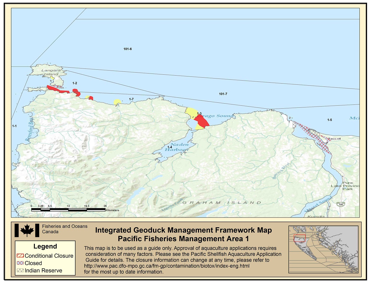
Area 1 IGMF Map - Text version
Area 1 IGMF Map indicating an Indian Reserve in 1-1; yellow, red and closed areas in 1-2; an Indian Reserve, yellow and red areas in 1-3; Indian Reserves and closed areas in 1-5; yellow and red areas in 1-7. Footnote 1
-
Area 2 East
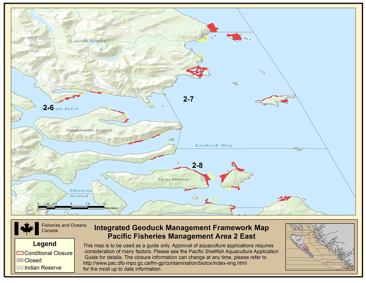
Area 2 East IGMF Map 1 - Text version
Area 2 East IGMF Map indicating yellow and red areas in 2-6; an Indian Reserve, yellow and red areas in 2-7; an Indian Reserve, yellow and red areas in 2-8. Footnote 1
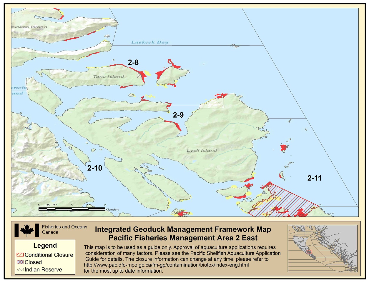
Area 2 East IGMF Map 2- Text version
Area 2 East IGMF Map indicating an Indian Reserve, yellow and red areas in 2-8; yellow and red areas in 2-9; yellow, red and conditionally closed areas in 2-11. Footnote 1
-
Area 2 North
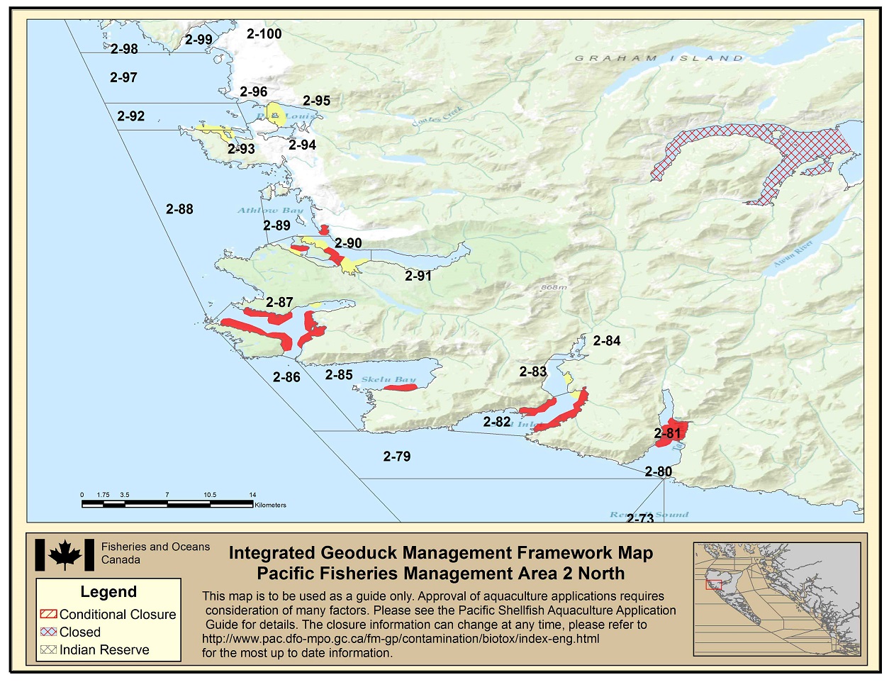
Area 2 North IGMF Map - Text version
Area 2 North IGMF Map indicating red areas in 2-80; red areas in 2-81; yellow and red areas in 2-82; yellow areas in 2-83; red areas in 2-85; yellow and red areas in 2-87; red areas in 2-89; yellow and red areas in 2-90; yellow areas in 2-92; yellow ares in 2-93; yellow areas in 2-95; yellow areas in 2-96. Footnote 1
-
Area 2 North East
Area 2 North East IGMF Map - Text version
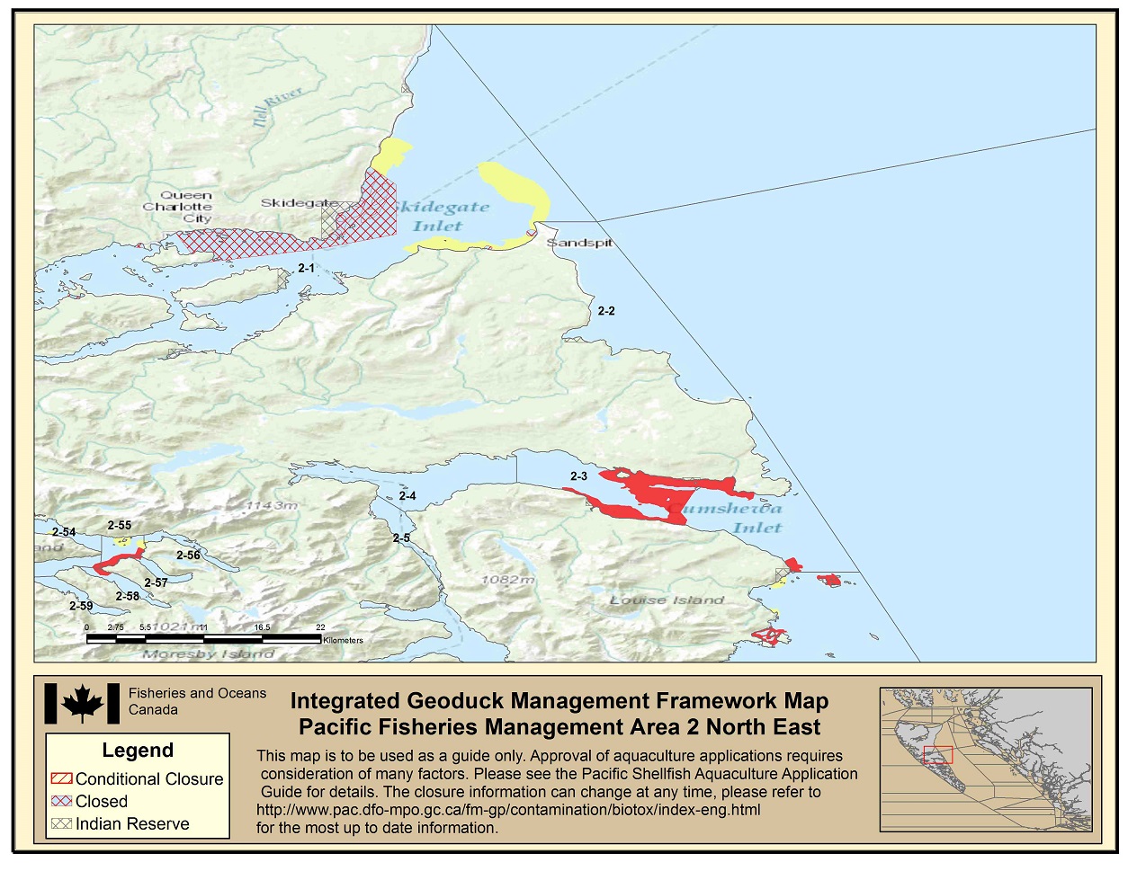
Area 2 North East IGMF Map indicating Indian Reserves, yellow and closed areas in 2-1; red areas in 2-3; yellow and red areas in 2-54; yellow and red areas in 2-55; red areas in 2-58. Footnote 1
-
Area 2 North West
Area 2 North West IGMF Map - Text version
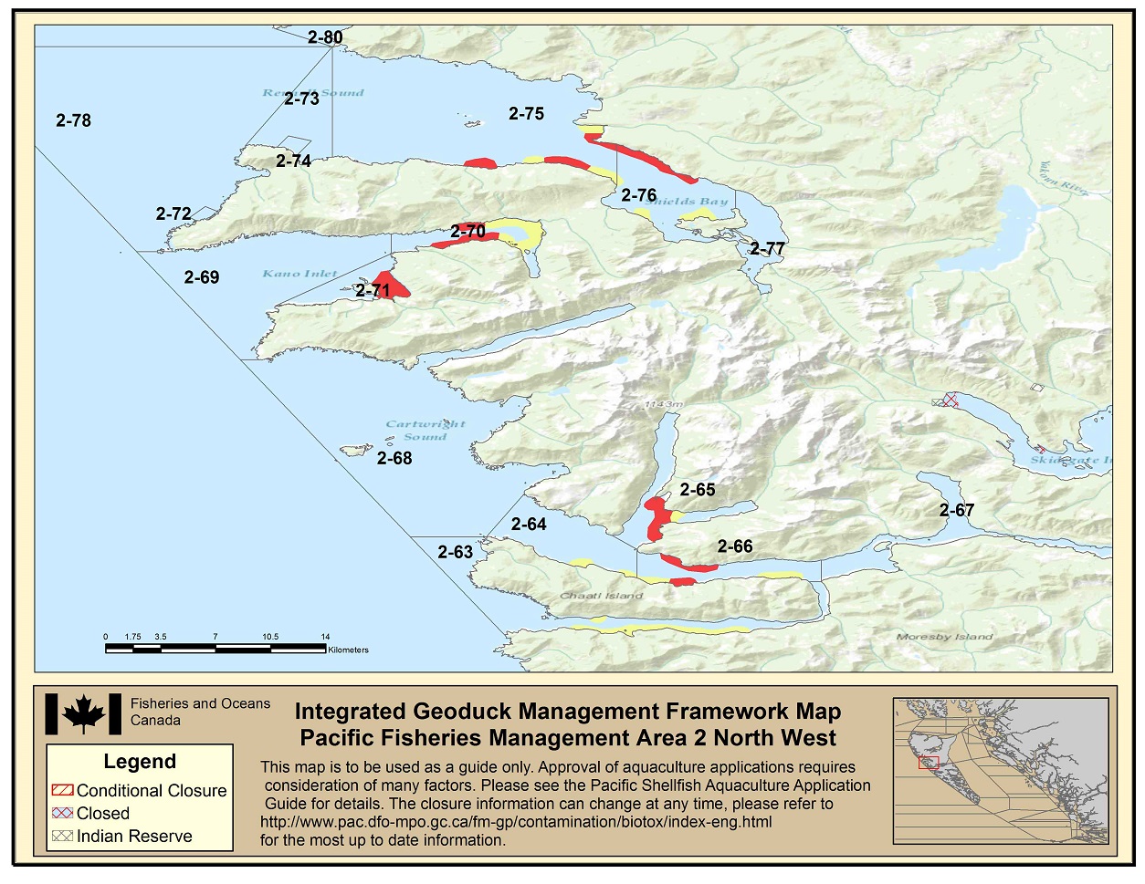
Area 2 North West IGMF Map indicating yellow areas in 2-63; yellow areas in 2-64; yellow and red areas in 2-65; yellow and red areas in 2-66; yellow and red areas in 2-70; red areas in 2-71; yellow and red areas in 2-75; yellow and red areas in 2-76. Footnote 1
-
Area 2 South
Area 2 South IGMF Map - Text version
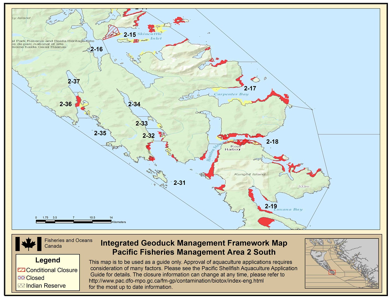
Area 2 South IGMF Map indicating yellow, red and conditionally closed areas in 2-15; yellow and red areas in 2-17; yellow, red and conditionally closed areas in 2-18; red areas in 2-31; red and closed areas in 2-32; yellow areas in 2-33; yellow and red areas in 2-36. Footnote 1
-
Area 2 South East
Area 2 South East IGMF Map - Text version
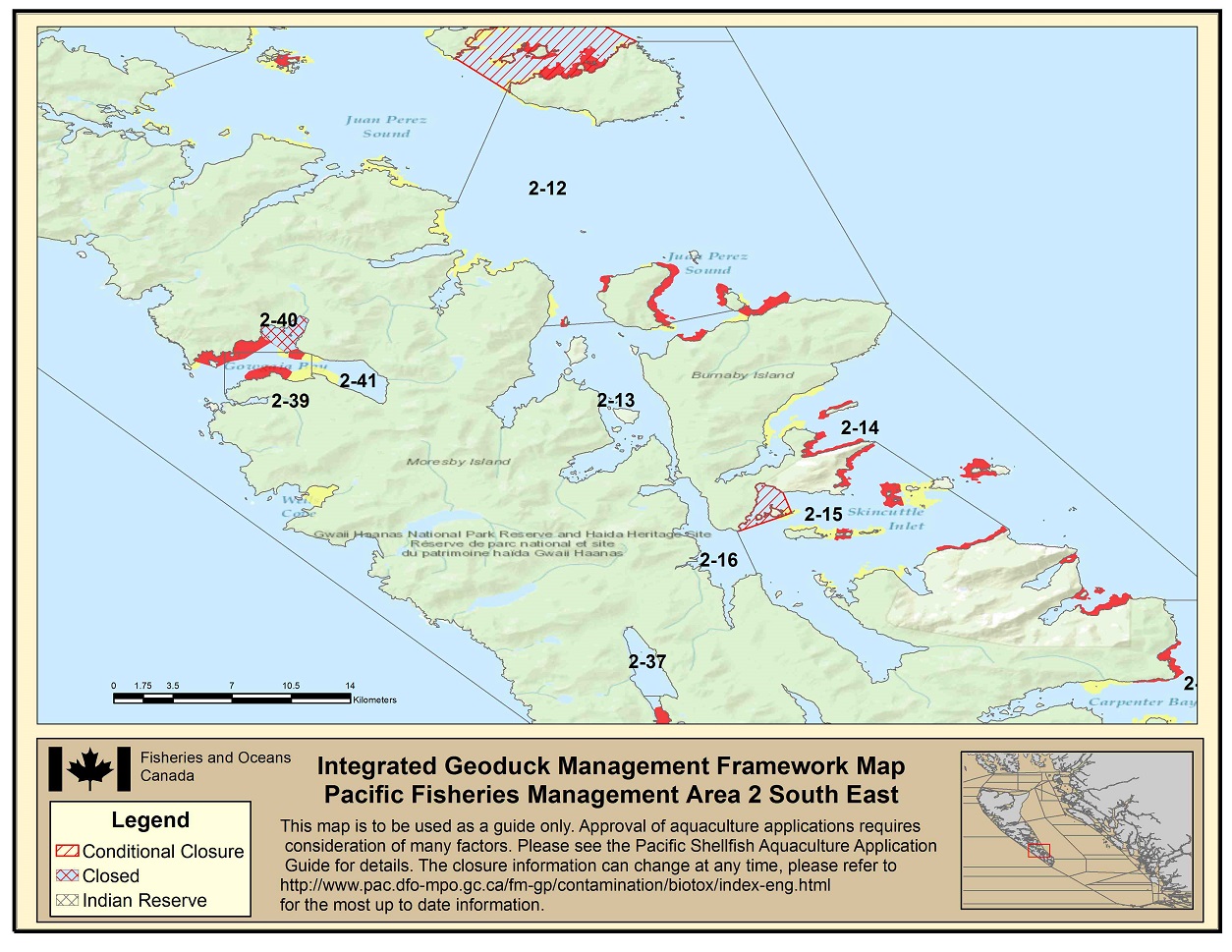
Area 2 South East IGMF Map indicating yellow and red areas in 2-12; yellow and red areas in 2-13; yellow and red areas in 2-14; yellow, red and conditionally closed areas in 2-15; yellow and red areas in 2-39; yellow, red and closed areas in 2-40; yellow areas in 2-41. Footnote 1
-
Area 2 South West
Area 2 South West IGMF Map - Text version
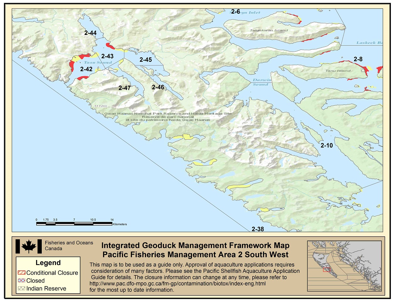
Area 2 South West IGMF Map indicating yellow and red areas in 2-6; yellow and red areas in 2-8; yellow areas in 2-38; yellow and red areas in 2-42; yellow and red areas in 2-43; yellow areas in 2-47. Footnote 1
-
Area 2 West
Area 2 West IGMF Map - Text version
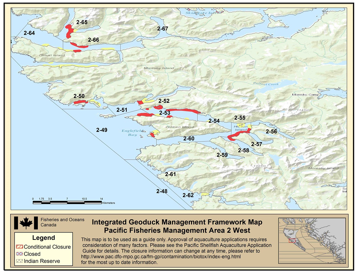
Area 2 West IGMF Map indicating yellow and red areas in 2-49; yellow and red areas in 2-50; yellow and red areas in 2-52; yellow and red areas in 2-53; yellow areas in 2-54; yellow and red areas in 2-55; yellow areas in 2-56; red areas in 2-57; red areas in 2-58; red areas in 2-60; yellow areas in 2-62; yellow areas in 2-64; yellow and red areas in 2-65; yellow and red areas in 2-66. Footnote 1
-
Area 3
Area 3 IGMF Map - Text version
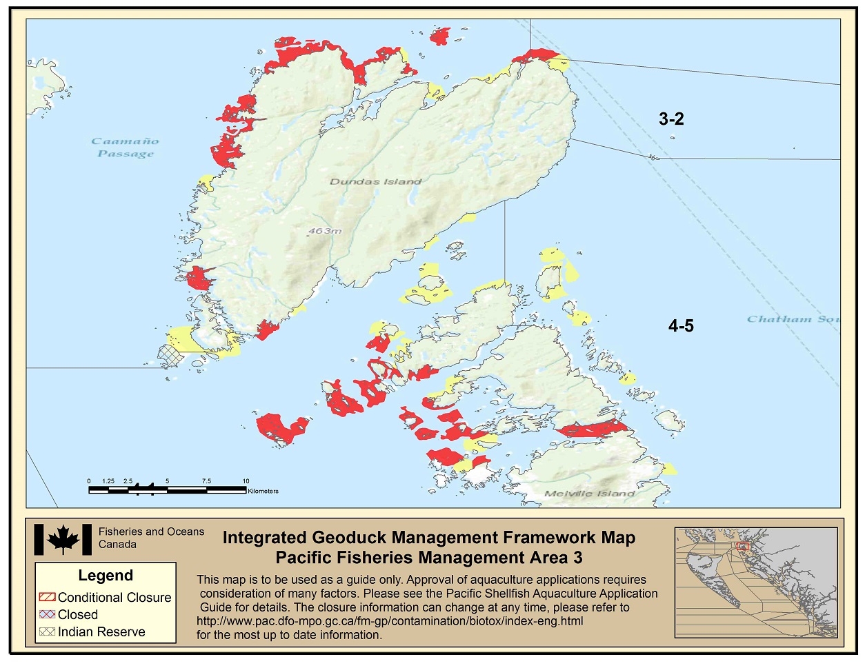
Area 3 IGMF Map indicating yellow and red areas in 3-2. Footnote 1
-
Area 4 South
Area 4 South IGMF Map - Text version
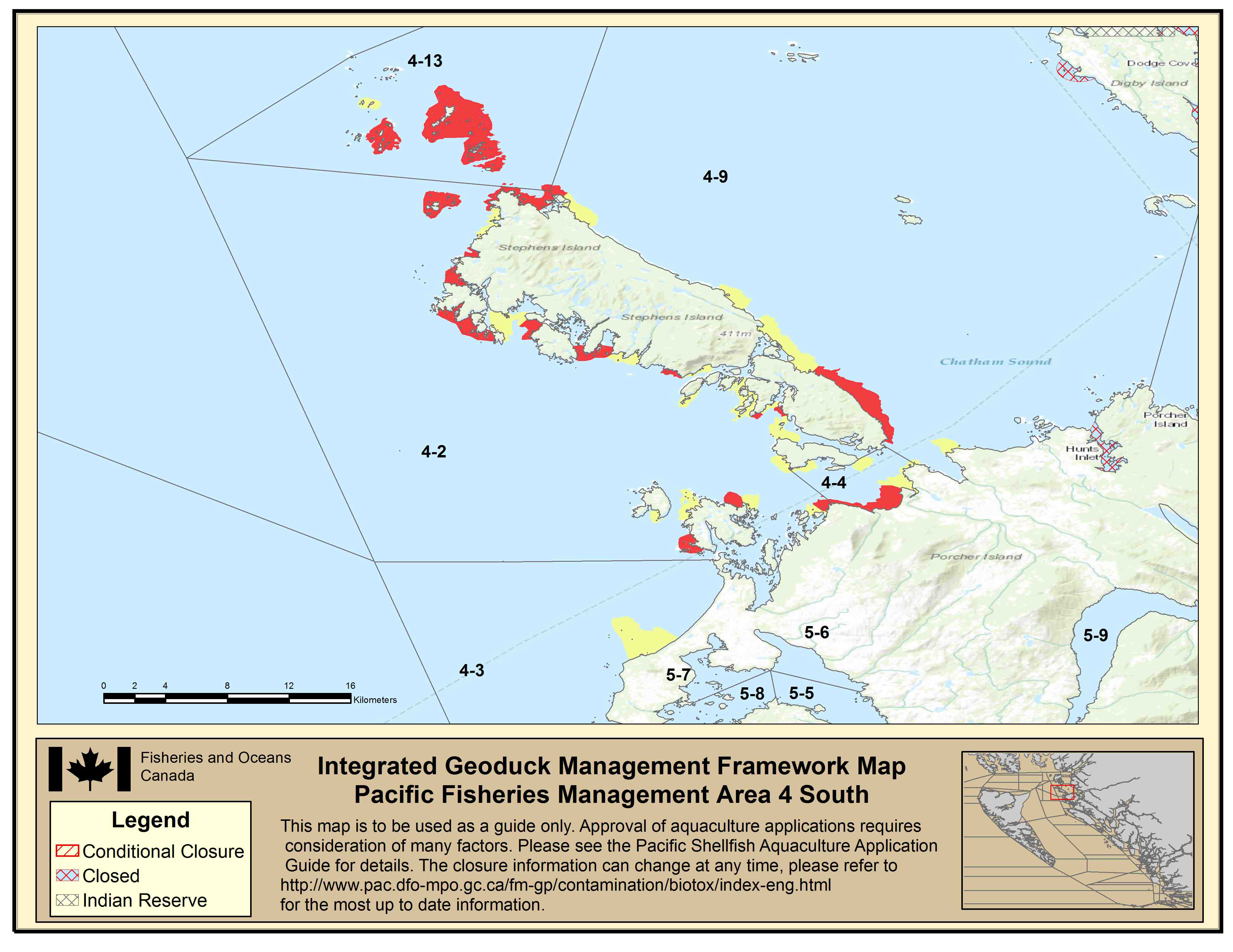
Area 4 South IGMF Map indicating yellow and red areas in 4-2; yellow areas in 4-3; yellow and red areas in 4-4; yellow and red areas in 4-9; yellow and red areas in 4-13. Footnote 1
-
Area 4 East
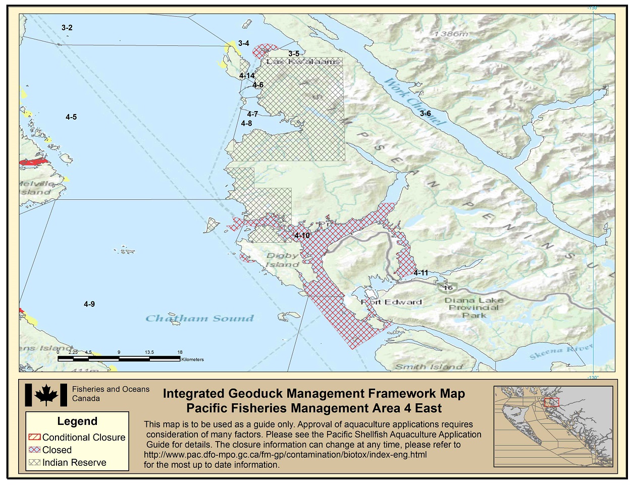
Area 4 East IGMF Map - Text version
Area 4 East IGMF Map indicating yellow and red areas in 4-5; Indian Reserves in 4-6; Indian Reserves in 4-7; an Indian Reserve in 4-8; yellow and red areas in 4-9; Indian Reserves and closed areas in 4-10; closed areas in 4-11; Indian Reserves in 4-14. Footnote 1
-
Area 5 North

Area 5 North IGMF Map - Text version
Area 5 North IGMF Map indicating closed areas in 5-3; an Indian Reserve, yellow, red and closed areas in 5-10; red areas in 5-11; yellow and red areas in 5-12. Footnote 1
-
Area 5 South
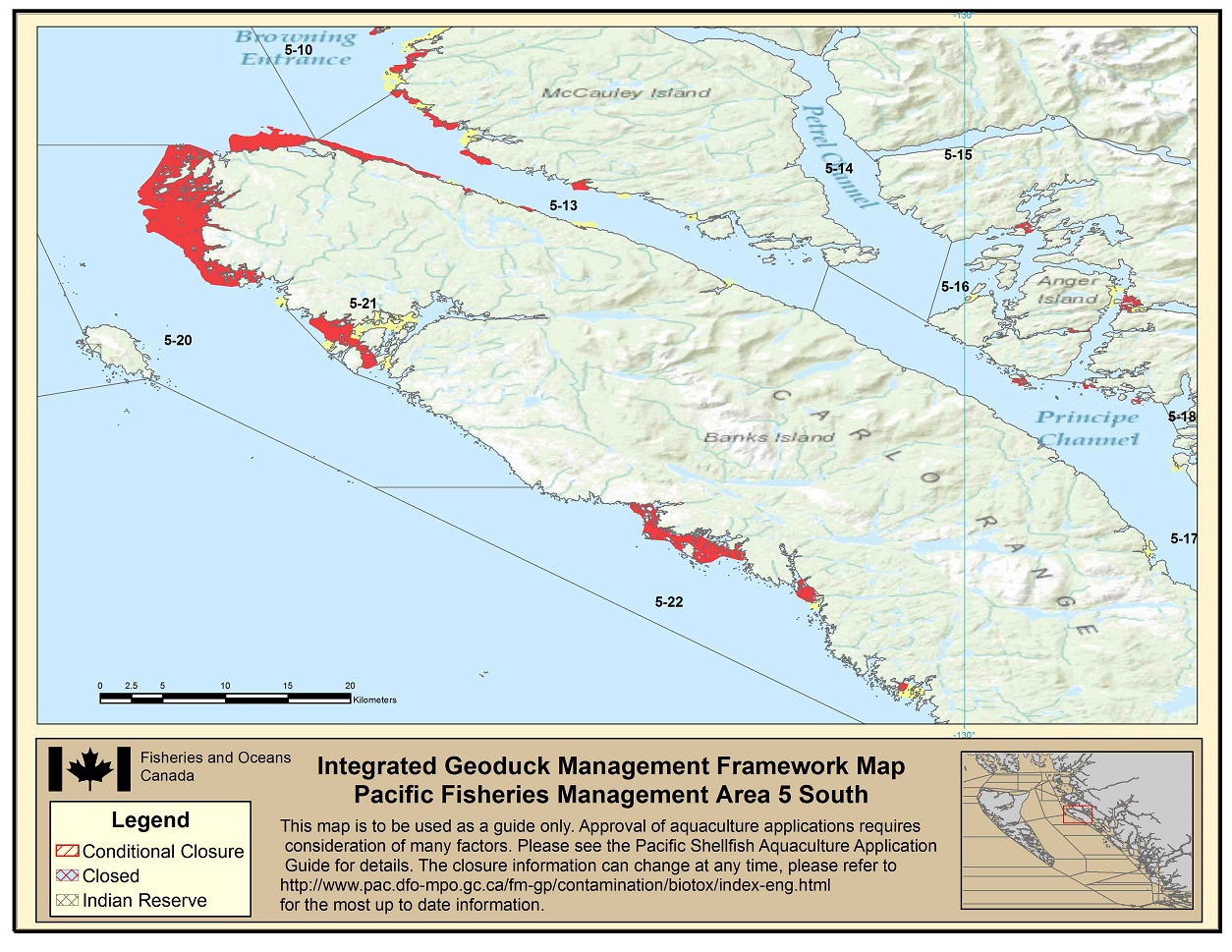
Area 5 South IGMF Map - Text version
Area 5 North IGMF Map indicating yellow and red areas in 5-10; yellow and red areas in 5-13; yellow and red areas in 5-16; yellow and red areas in 5-17; yellow and red areas in 5-20; yellow and red areas in 5-22. Footnote 1
-
Area 6 North

Area 6 North IGMF Map - Text version
Area 6 North IGMF Map indicating yellow and red areas in 6-5; yellow and red areas in 6-9. Footnote 1
-
Area 6 South
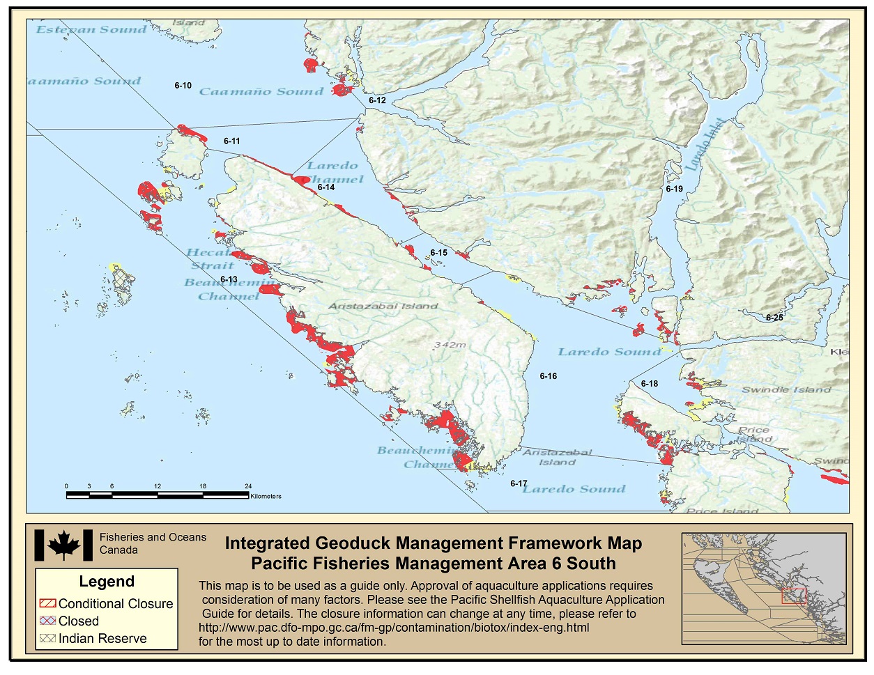
Area 6 South IGMF Map - Text version
Area 6 South IGMF Map indicating yellow and red areas in 6-10; red areas in 6-11; yellow and red areas in 6-12; yellow and red areas in 6-13; yellow and red areas in 6-14; yellow and red areas in 6-15; yellow and red areas in 6-16; yellow and red areas in 6-17; yellow and red areas in 6-18; yellow and red areas in 6-19. Footnote 1
-
Area 7 North
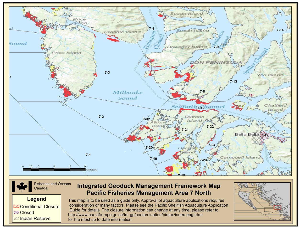
Area 7 North IGMF Map - Text version
Area 7 North IGMF Map indicating yellow and red areas in 7-3; yellow and red areas in 7-4; red and closed areas in 7-8; yellow and red areas in 7-9; red areas in 7-12; an Indian Reserve and closed areas in 7-13; an Indian Reserve and closed areas in 7-17; yellow and red areas in 7-19; yellow and red areas in 7-20; yellow and red areas in 7-21; yellow and red areas in 7-22; yellow and red areas in 7-23; yellow and red areas in 7-24; yellow and red areas in 7-32. Footnote 1
-
Area 7 South
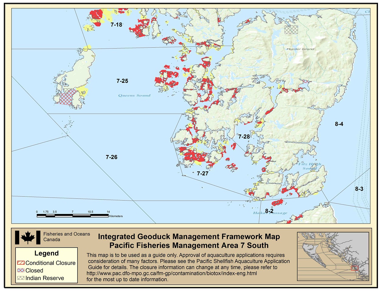
Area 7 South IGMF Map - Text version
Area 7 South IGMF Map indicating yellow and red areas in 7-18; an Indian Reserve, yellow, red and closed areas in 7-25; yellow and red areas in 7-27; yellow and red areas in 7-28. Footnote 1
-
Area 8, 9, 10
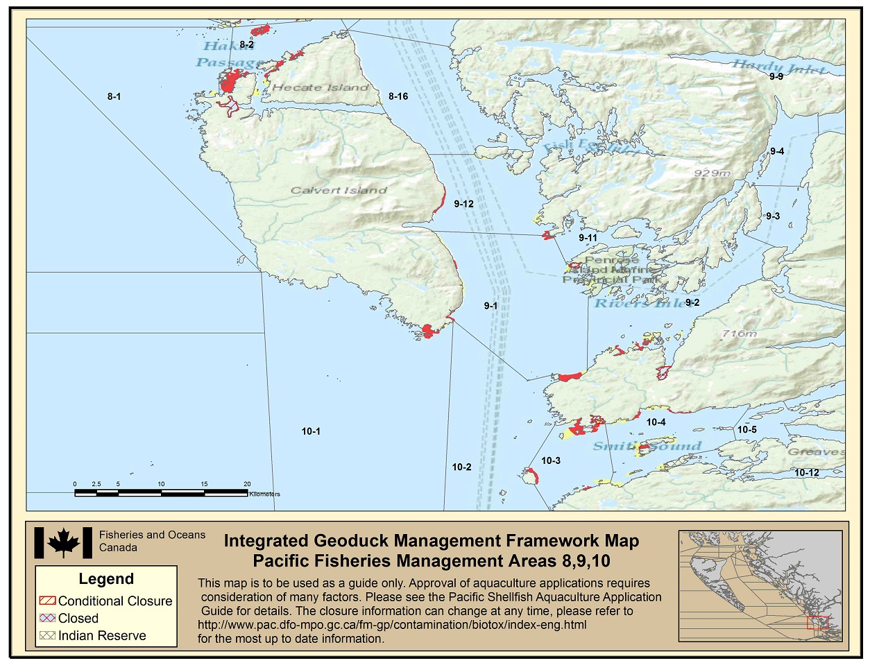
Area 8, 9, 10 IGMF Map - Text version
Area 8, 9, 10 IGMF Map indicating yellow and red areas in 8-1; yellow, red and closed areas in 8-2; yellow and red areas in 9-1; yellow, red and closed areas in 9-2; red areas in 9-11; yellow and red areas in 9-12; red areas in 10-1; red areas in 10-3; an Indian Reserve, yellow and red areas in 10-4. Footnote 6
South Coast Maps
South Coast Integrated Geoduck Management Framework Maps
-
Area 12 North
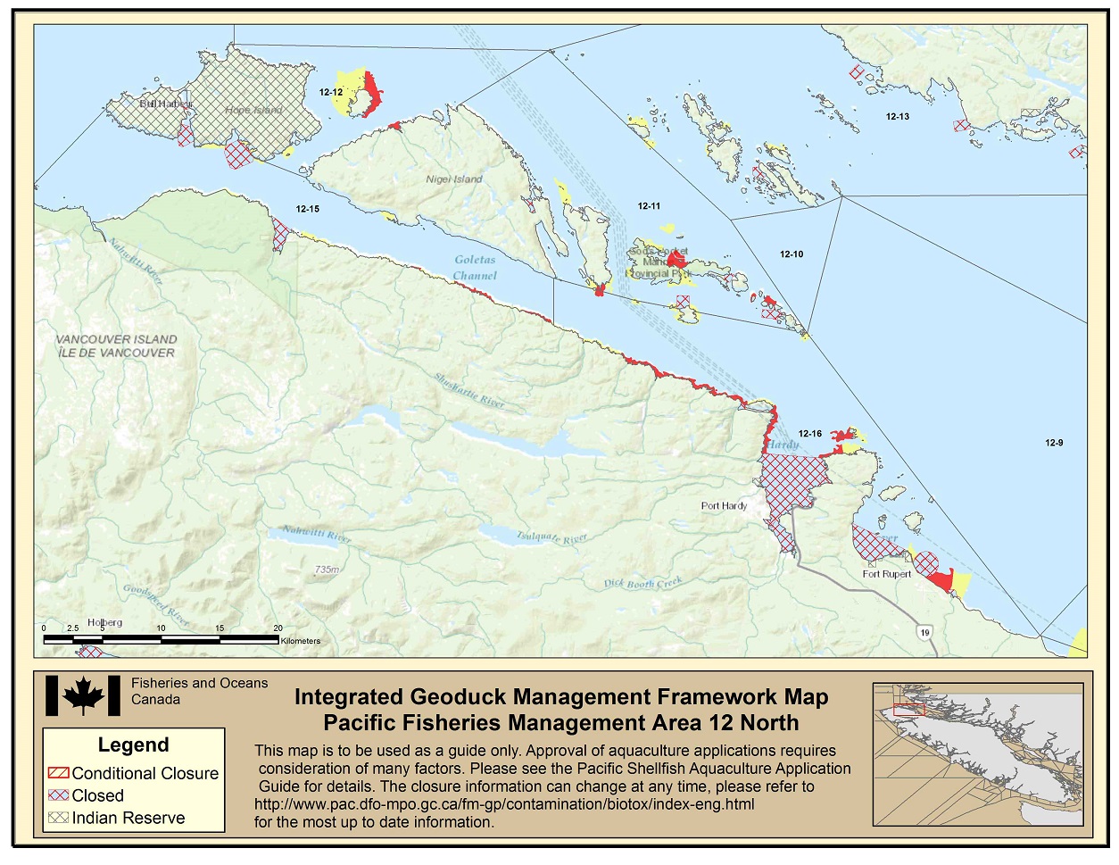
Area 12 North IGMF Map - Text version
Area 12 North IGMF Map indicating closed areas in Subarea 12-11; Indian Reserves, yellow and red areas in Subarea 12-12; an Indian Reserve, yellow and closed areas in Subarea 12-13; yellow, red and closed areas in Subarea 12-15; Indian Reserves, yellow, red and closed areas in Subarea 12-16. Footnote 2
-
Area 12 South
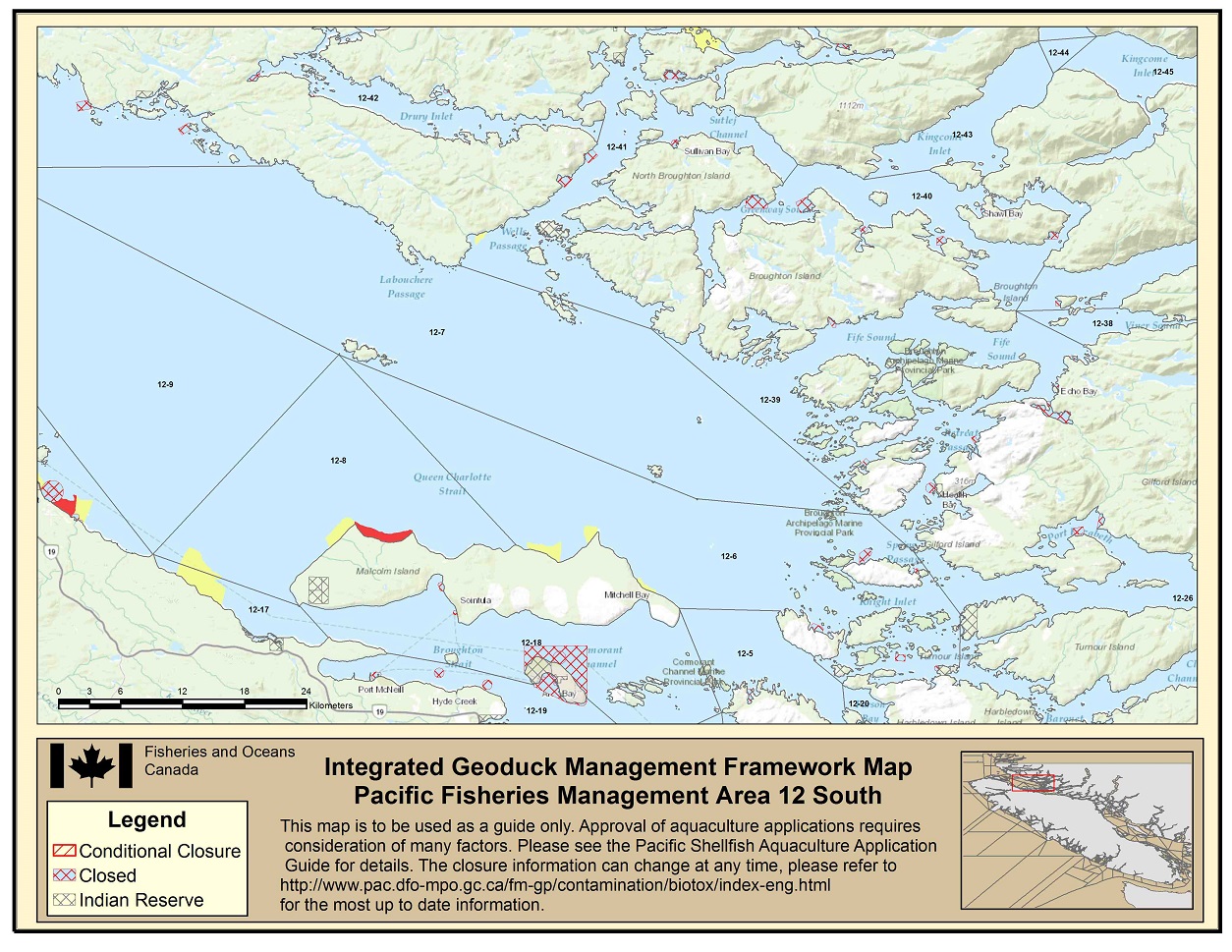
Area 12 South IGMF Map - Text version
Area 12 South IGMF Map indicating yellow and closed areas in Subarea 12-6; yellow and red areas in Subarea 12-8; a yellow area in 12-17; an Indian Reserve and closed areas in Subarea 12-18; closed areas in Subarea 12-19; closed areas in Subarea 12-26; closed areas in 12-39; closed area in 12-40; closed and yellow areas in 12-41; and closed areas in 12-42. Footnote 2
-
Area 13
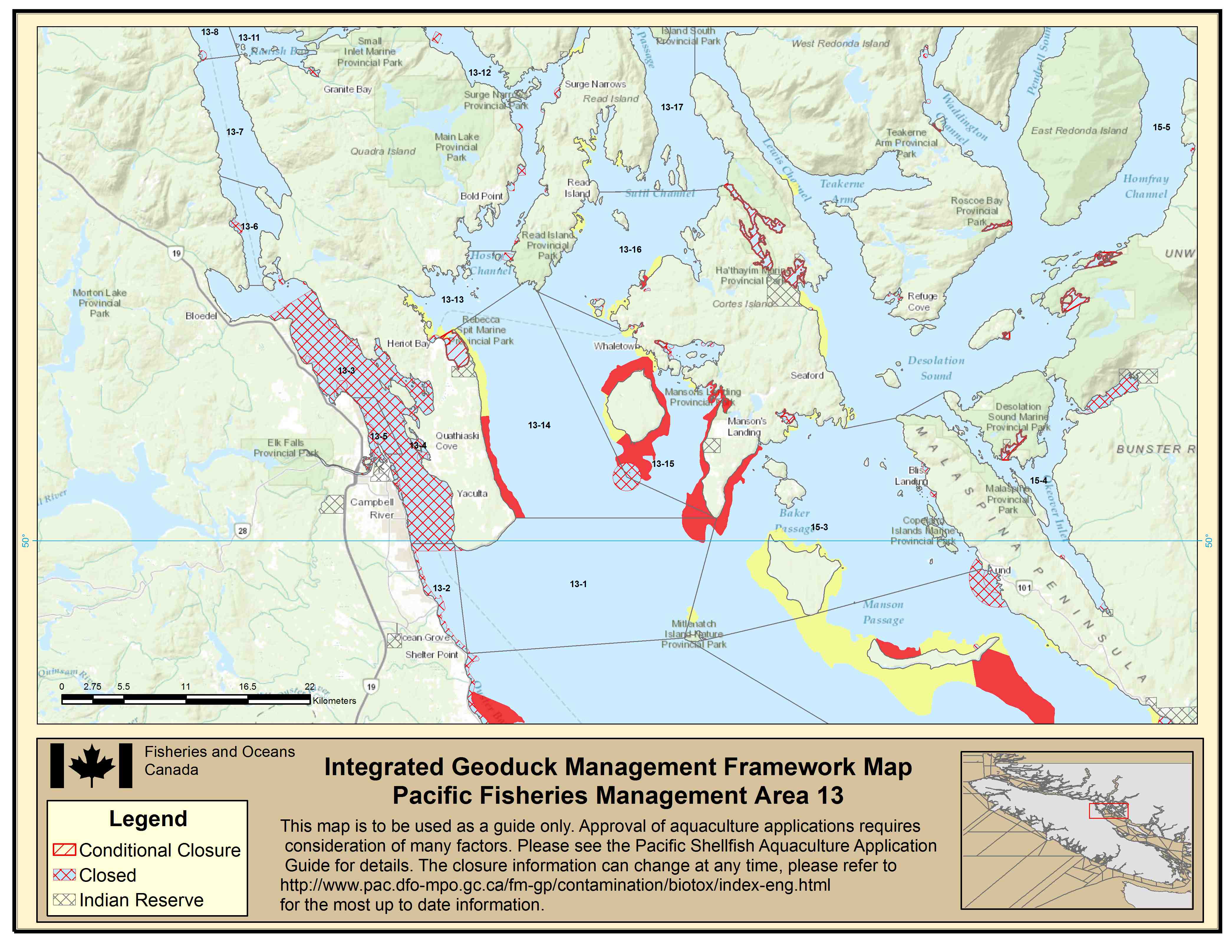
Area 13 IGMF Map - Text version
Area 13 IGMF Map indicating closed areas in Subarea 13-2; closed areas in 13-3; closed areas in 13-4; closed areas in 13-5; closed areas in 13-6; closed areas in 13-8; closed areas in 13-11; closed areas in 13-12; closed and yellow areas in 13-13; an Indian Reserve, yellow, red, and closed areas in 13-14; an Indian Reserve, yellow, red, and closed areas in 13-15; yellow, red, and closed areas in 13-16; yellow areas in 13-17. Footnote 2
-
Area 14 North
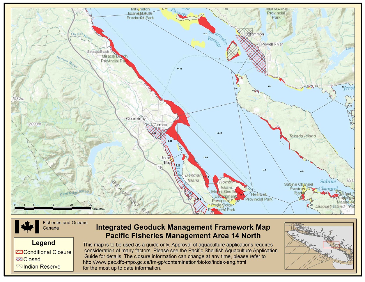
Area 14 North IGMF Map - Text version
Area 14 North IGMF Map indicating red and yellow areas in 14-7; yellow, red and closed areas in 14-8; red areas in 14-9; red areas in 14-10; yellow, red and closed areas in 14-11; red and closed areas in 14-13; closed areas in 14-14; yellow, red and closed areas in 14-15. Footnote 2
-
Area 14 South
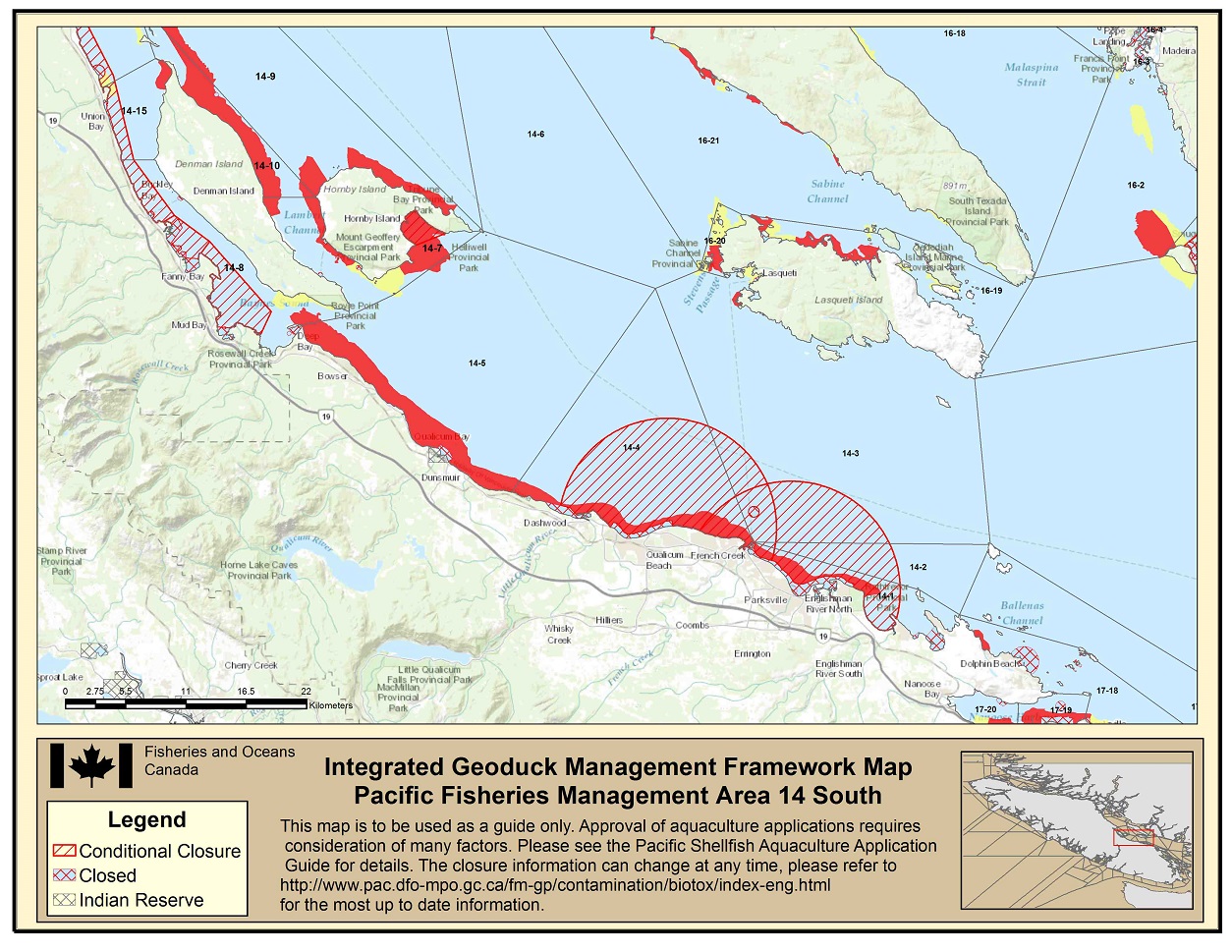
Area 14 South IGMF Map - Text version
Area 14 South IGMF Map indicating conditionally closed, closed and red areas in 14-1; conditionally closed areas in 14-2; conditonally closed, yellow, red and closed areas in 14-3; conditionally closed, red and closed areas in 14-4; yellow, red and closed areas in 14-6; yellow and red closed areas in 14-7; yellow, red, closed and conditionally closed areas in 14-8; red areas in 14-9; red areas in 14-10; yellow, red, closed and conditionally closed areas in 14-15. Footnote 2
-
Area 15 North
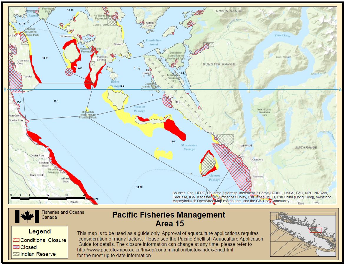
Area 15 North IGMF Map - Text version
Area 15 North IGMF Map indicating an Indian Reserve, yellow, red and closed areas in 15-2; yellow, red and closed areas in 15-3; an Indian Reserve, closed and conditionally closed areas in 15-4. Footnote 2
-
Area 16
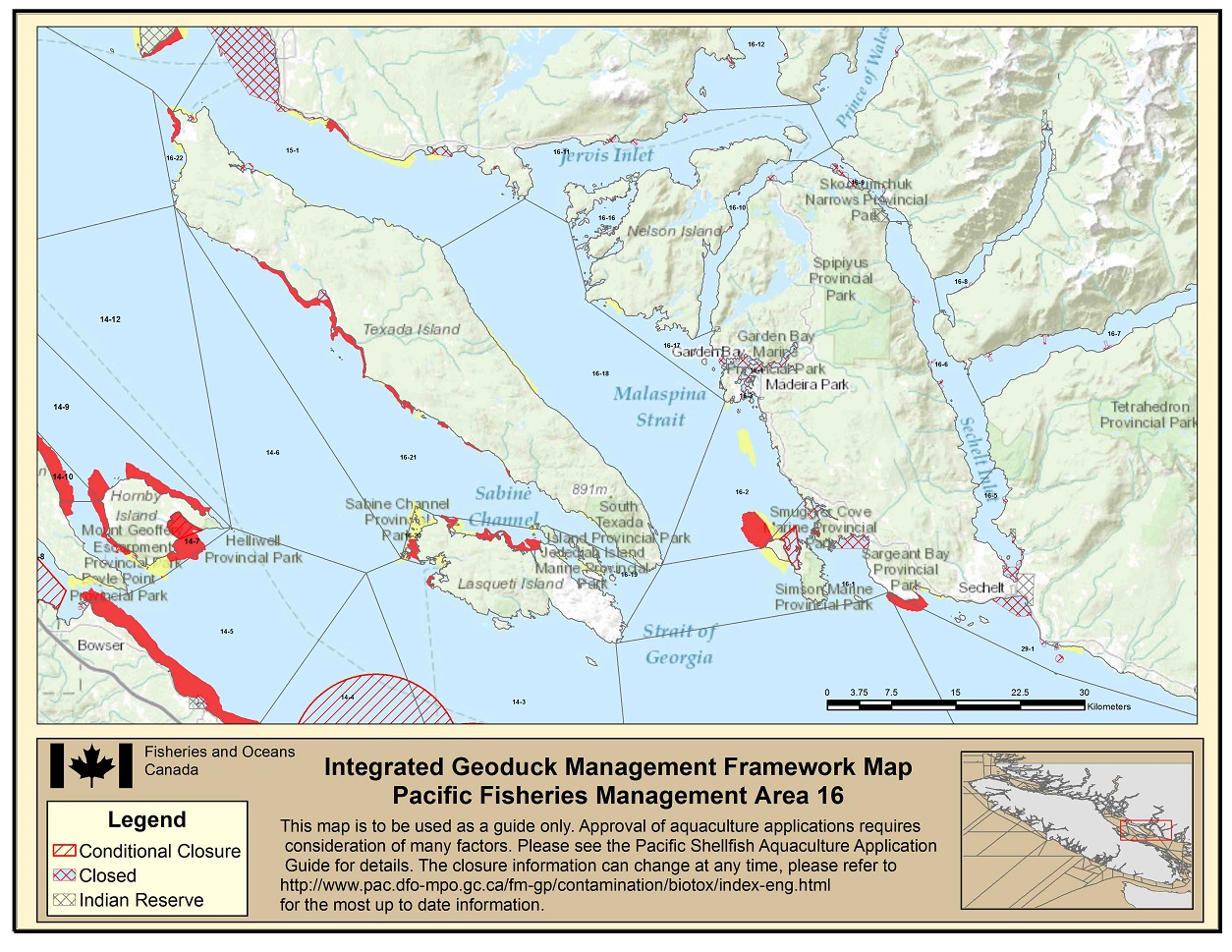
Area 16 IGMF Map - Text version
Area 16 IGMF Map indicating yellow, red, closed and conditionally closed areas in 16-1; yellow, red and closed areas in 16-2; closed areas in 16-3; closed areas in 16-4; closed areas in 16-5; closed areas in 16-6; closed areas in 16-7; an Indian Reserve and closed areas in 16-8; closed areas in 16-9; closed areas in 16-10; closed areas in 16-11; closed areas in 16-12; closed areas in 16-16; yellow and closed areas in 16-17; yellow areas in 16-18; yellow and closed areas in 16-19; yellow and red areas in 16-20; yellow and red areas in 16-21; yellow and red areas in 16-22. Footnote 2
-
Area 17
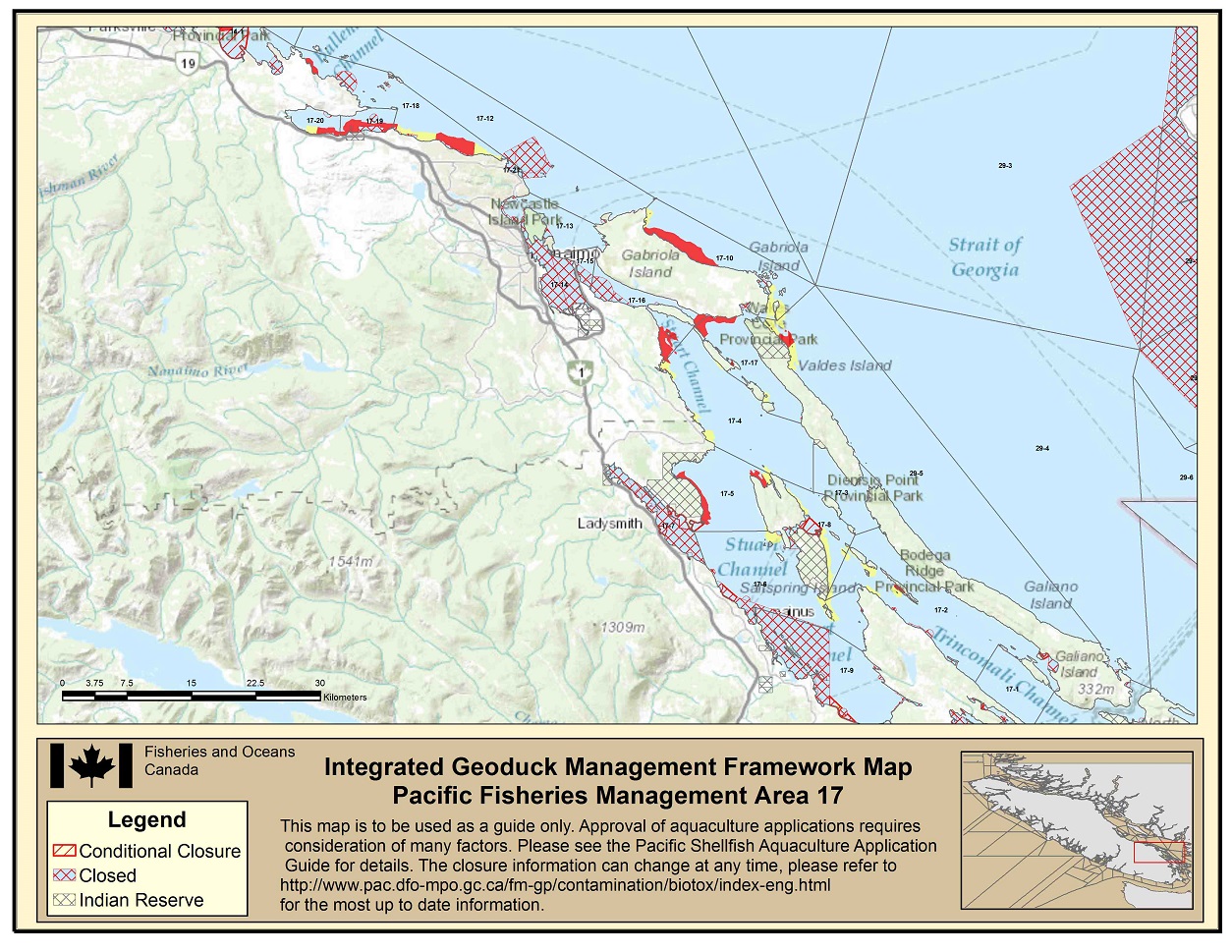
Area 17 IGMF Map - Text version
Area 17 IGMF Map indicating yellow and closed areas in 17-2; yellow, red and closed areas in 17-4; an Indian Reserve yellow and red areas in 17-5; an Indian Reserve, yellow and closed areas in 17-6; closed areas in 17-7; an Indian Reserve, yellow and closed areas in 17-8; yellow and closed areas in 17-9; yellow, red and closed areas in 17-10; closed areas in 17-12; closed areas in 17-13; closed areas in 17-14; closed areas in 17-15; closed and red areas in 17-16; an Indian Reserve, yellow, and red areas in 17-17; yellow, red and closed areas in 17-18; red and closed areas in 17-19; yellow and red areas in 17-20; yellow and closed areas in 17-21. Footnote 2
-
Area 18
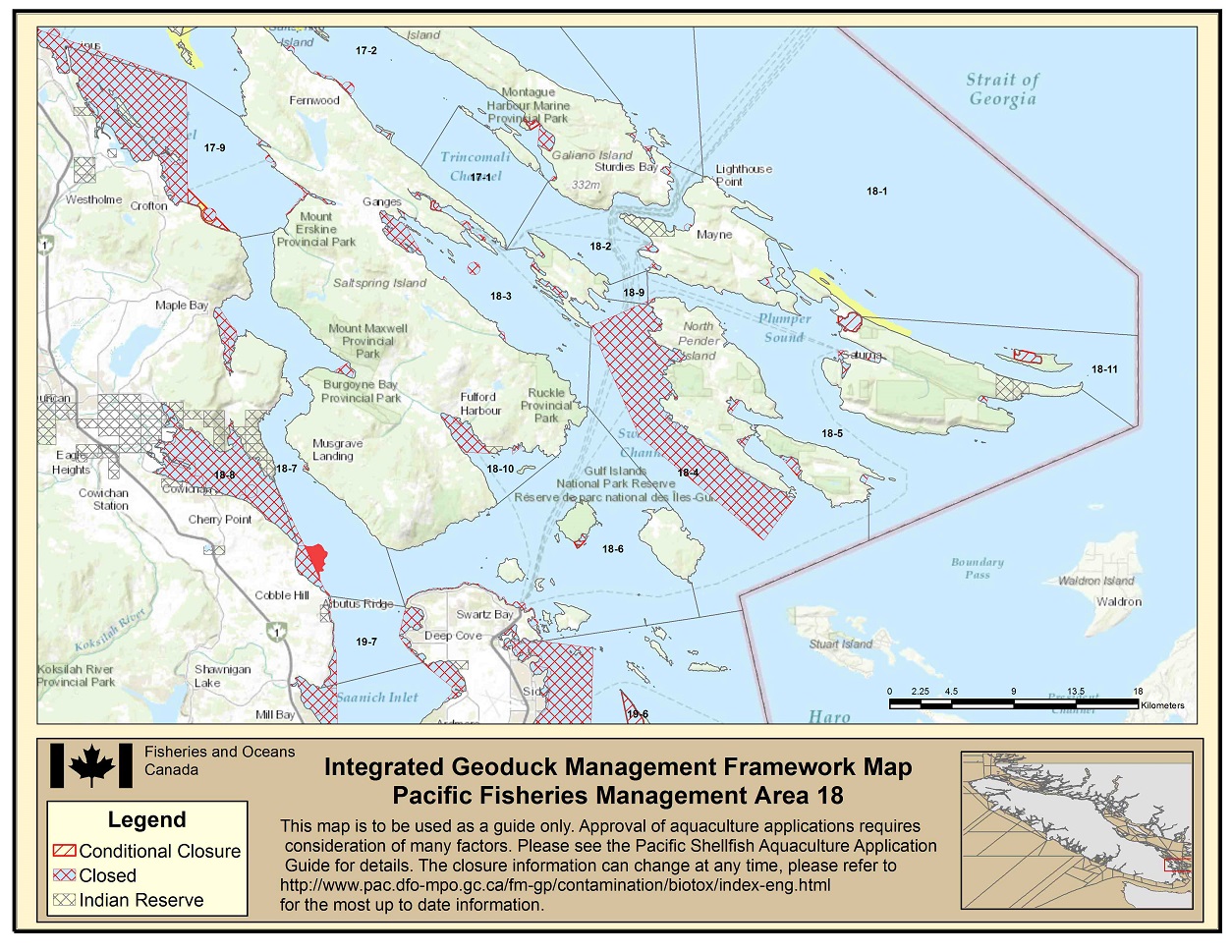
Area 18 IGMF Map - Text version
Area 18 IGMF Map indicating yellow areas in 18-1; an Indian Reserve and closed areas in 18-2; closed areas in 18-4; an Indian reserve, and closed areas in 18-5; closed areas in 18-6; an Indian Reserve, red and closed areas in 18-7; Indian Reserves and closed areas in 18-8; closed areas in 18-10; an Indian Reserve and conditionally closed areas in 18-11. Footnote 2
-
Area 19
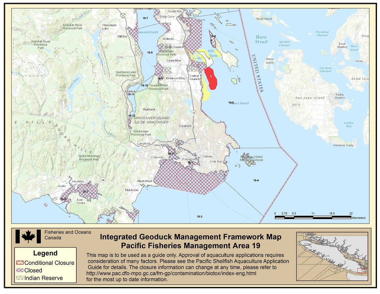
Area 19 IGMF Map - Text version
Area 19 IGMF Map indicating closed areas in 19-1; closed areas in 19-2; closed areas in 19-3; closed areas in 19-4; An Indian Reserve, yellow, red and closed areas in 19-5; conditionally closed areas in 19-6; closed areas in 19-7; Indian Reserves and closed areas in 19-8; an Indian Reserve and closed areas in 19-9; closed areas in 19-11; closed areas in 19-12. Footnote 2
-
Area 20
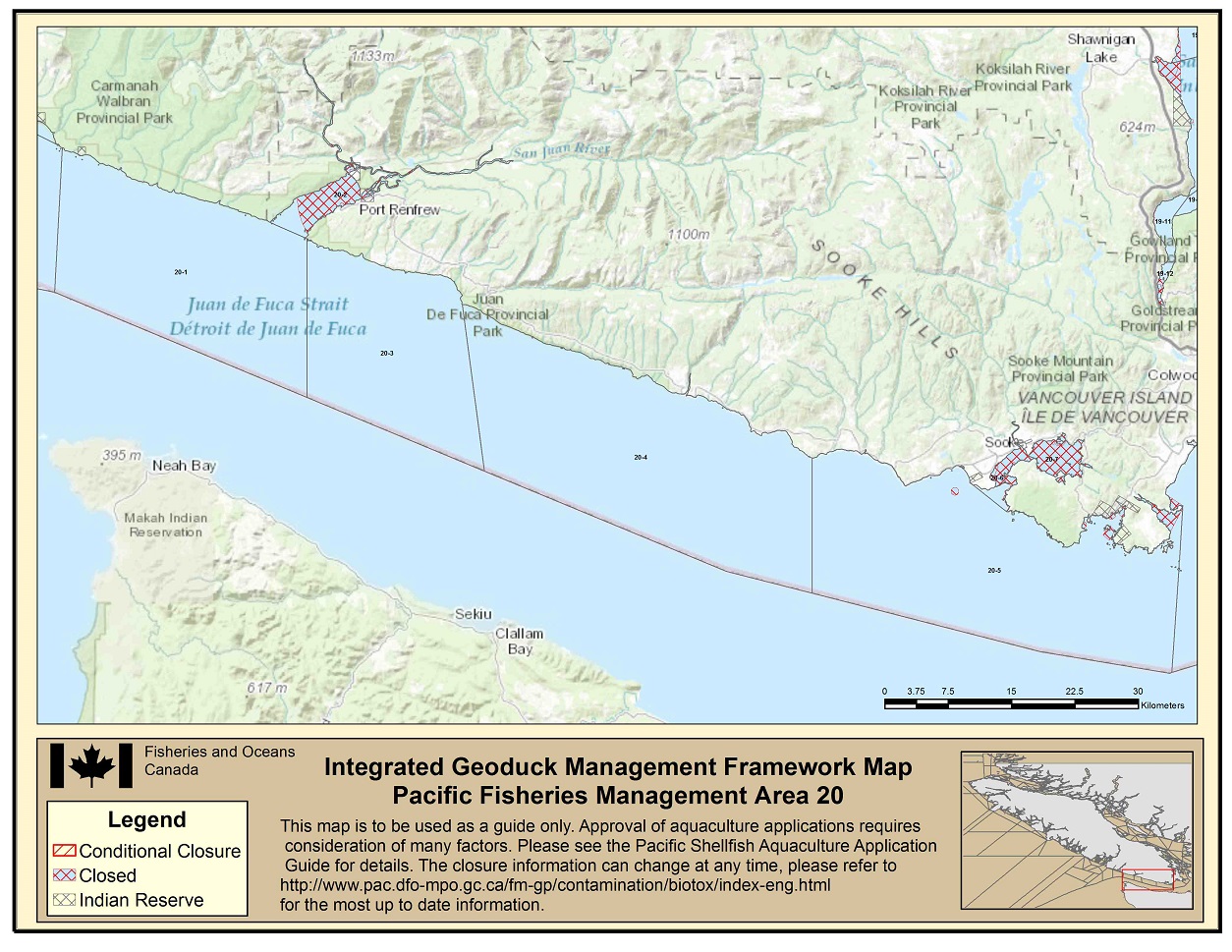
Area 20 IGMF Map - Text version
Area 20 IGMF Map indicating an Indian Reserve in 20-1; closed areas in 20-2; closed areas in 20-5; closed areas in 20-6; closed areans in 20-7. Footnote 2
-
Area 23
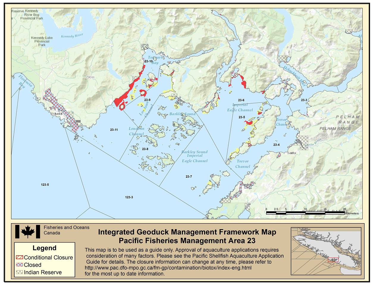
Area 23 IGMF Map - Text version
Area 23 IGMF Map indicating an Indian Reserve and closed areas in 23-1; closed areas in 23-3; an Indian Reserve, yellow and closed areas in 23-4; yellow, red and closed areas in 23-5; yellow, red and closed areas in 23-6; Indian Reserves, yellow and closed areas in 23-7; an Indian Reserve, yellow and closed areas in 23-8; yellow, red and closed areas in 23-9; Indian Reserves, yellow, red and closed areas in 23-10; closed areas in 23-11. Footnote 2
-
Area 24 North
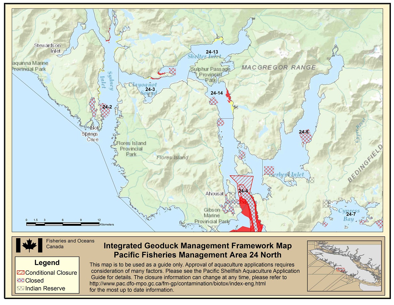
Area 24 North IGMF Map - Text version
Area 24 North IGMF Map indicating closed and yellow areas in 24-2; red and closed areas in 24-3; yellow, red and closed areas in 24-4; an Indian Reserve and closed areas in 24-5; Indian Reserves and closed areas in 24-7; yellow areas in 24-13; an Indian Reserve, yellow, red and closed areas in 24-14; Footnote 2
-
Area 24 South

Area 24 South IGMF Map - Text version
Area 24 South IGMF Map indicating an Indian Reserve, red, closed and conditionally closed areas in 24-4; Indian Reserves, yellow, red and closed areas in 24-6; Indian Reserves, yellow, red and closed areas in 24-7; Indian Reserves, red and closed areas in 24-8; an Indian Reserve, red and closed areas in 24-9; closed areas in 24-10; closed areas in 24-11. Footnote 2
-
Area 25 North
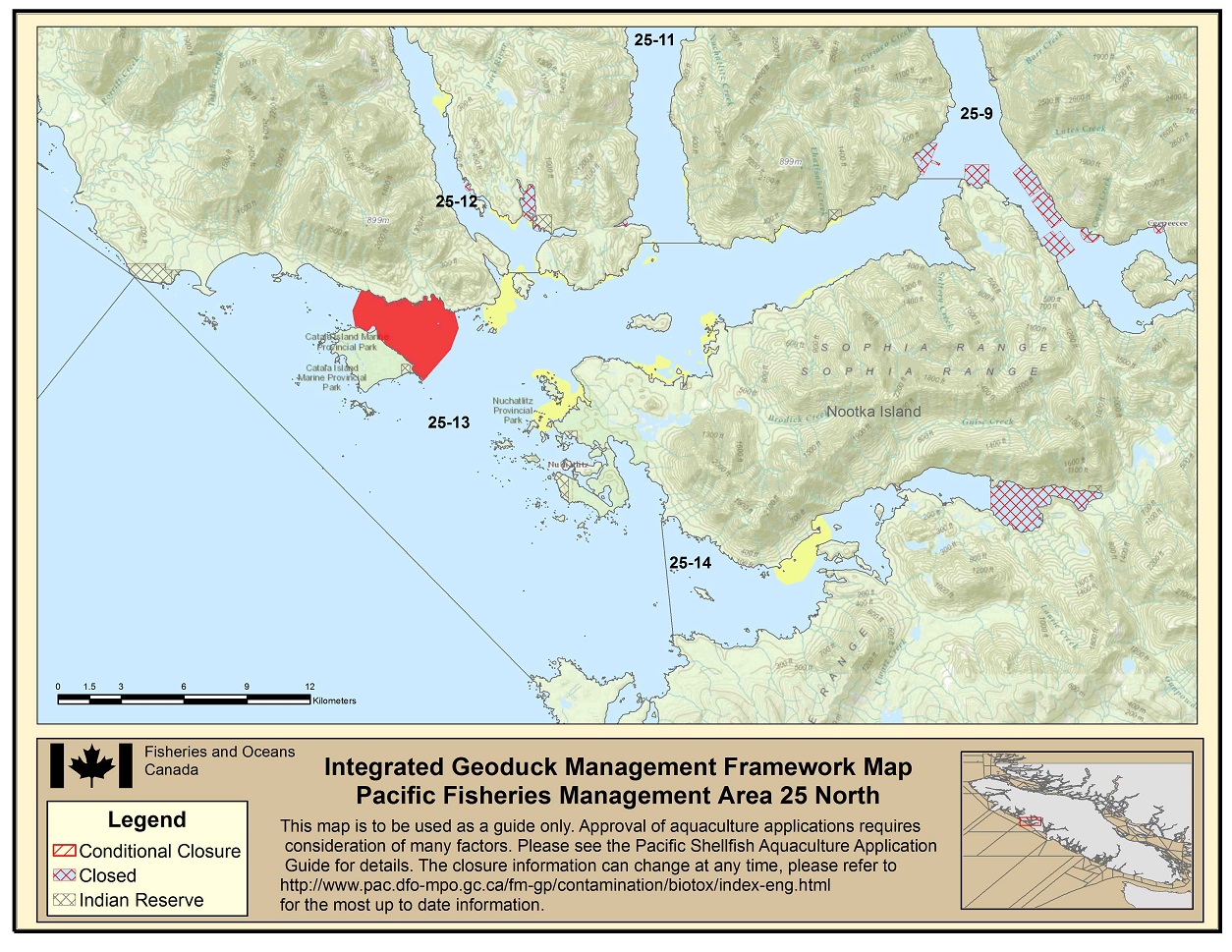
Area 25 North IGMF Map - Text version
Area 12 North IGMF Map indicating closed areas in Subarea 12-11; Indian Reserves, yellow and red areas in Subarea 12-12; an Indian Reserve, yellow and closed areas in Subarea 12-13; yellow, red and closed areas in Subarea 12-15; Indian Reserves, yellow, red and closed areas in Subarea 12-16. Footnote 2
-
Area 25 South
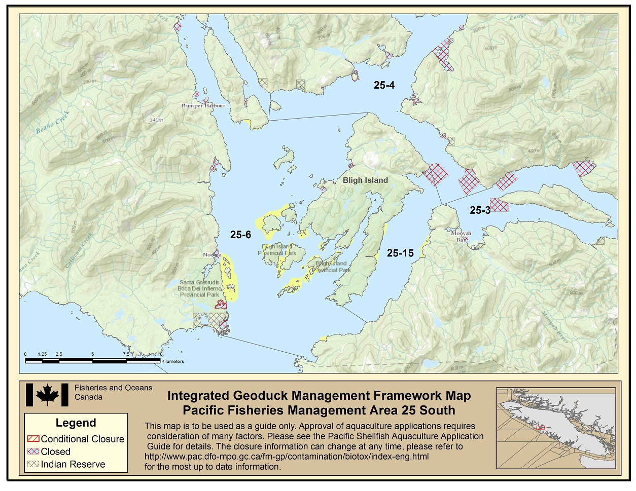
Area 25 South IGMF Map - Text version
Area 12 North IGMF Map indicating closed areas in Subarea 12-11; Indian Reserves, yellow and red areas in Subarea 12-12; an Indian Reserve, yellow and closed areas in Subarea 12-13; yellow, red and closed areas in Subarea 12-15; Indian Reserves, yellow, red and closed areas in Subarea 12-16. Footnote 2
-
Area 26 North
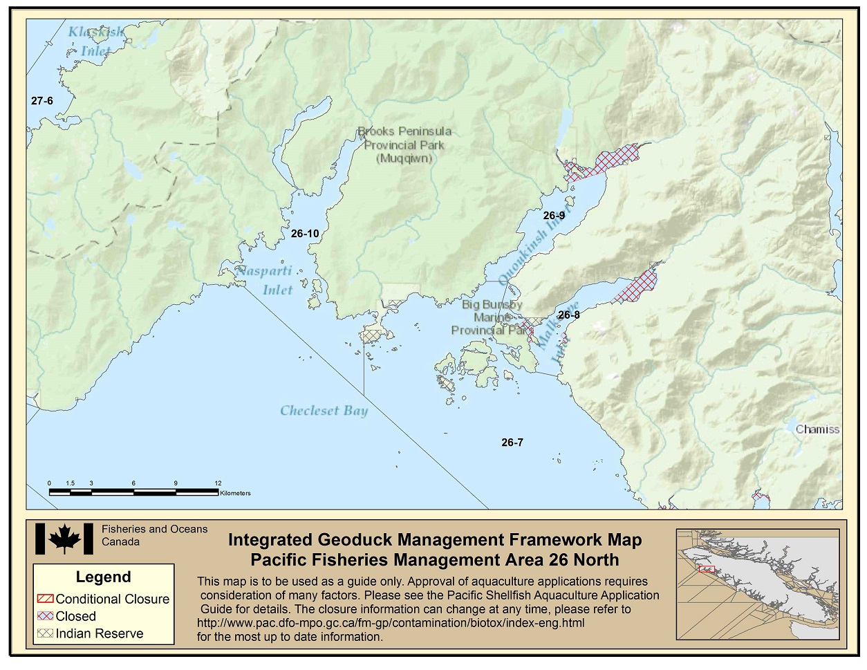
Area 26 North IGMF Map - Text version
Area 12 North IGMF Map indicating closed areas in Subarea 12-11; Indian Reserves, yellow and red areas in Subarea 12-12; an Indian Reserve, yellow and closed areas in Subarea 12-13; yellow, red and closed areas in Subarea 12-15; Indian Reserves, yellow, red and closed areas in Subarea 12-16. Footnote 2
-
Area 26 South
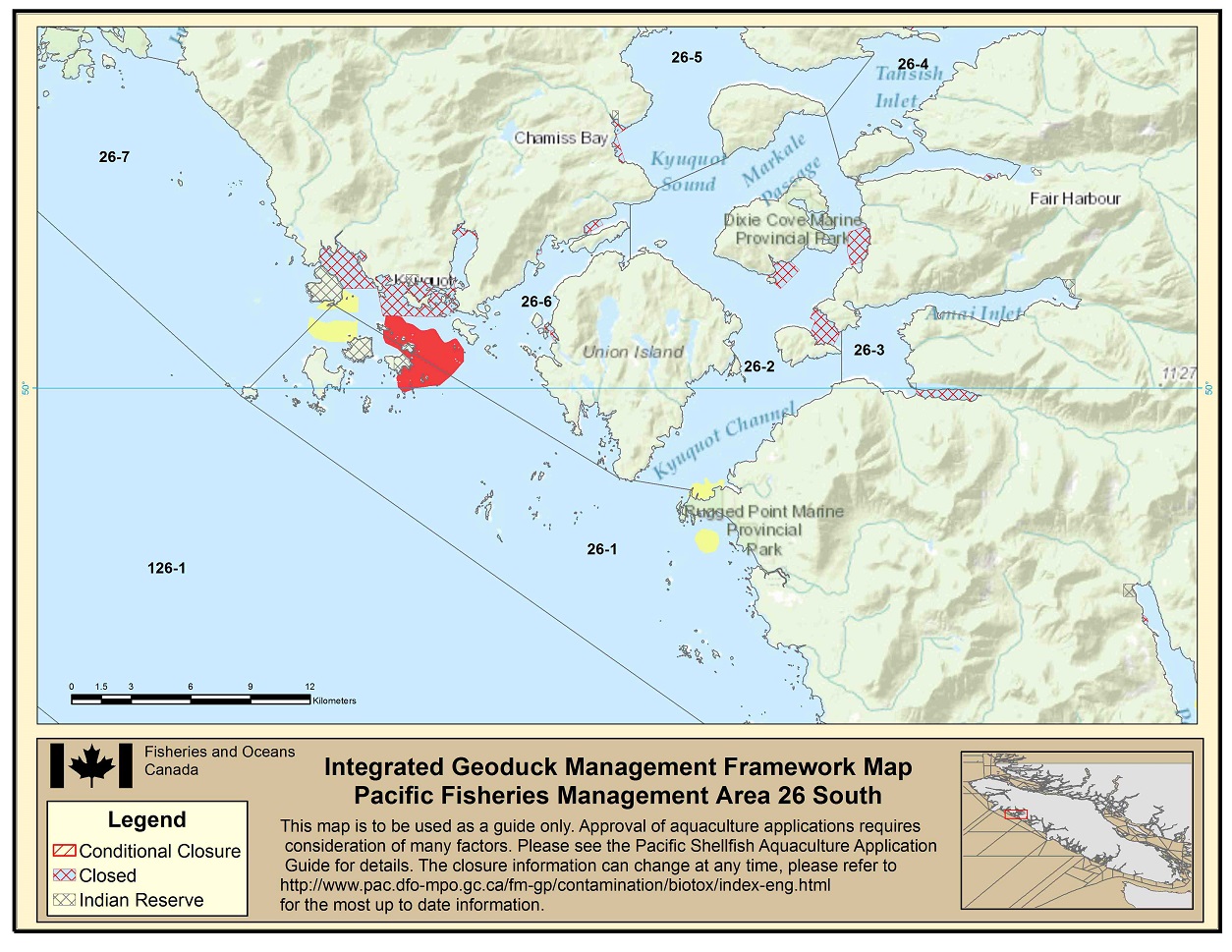
Area 26 South IGMF Map - Text version
Area 12 North IGMF Map indicating closed areas in Subarea 12-11; Indian Reserves, yellow and red areas in Subarea 12-12; an Indian Reserve, yellow and closed areas in Subarea 12-13; yellow, red and closed areas in Subarea 12-15; Indian Reserves, yellow, red and closed areas in Subarea 12-16. Footnote 2
-
Area 27
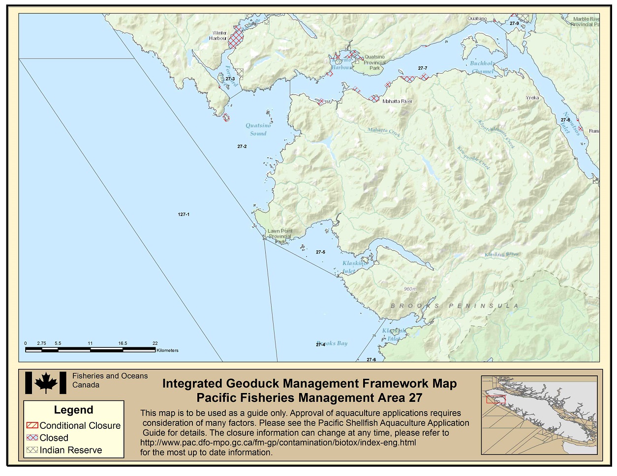
Area 27 IGMF Map - Text version
Area 27 IGMF Map indicating closed areas in 27-2; an Indian Reserve and closed areas in 27-3; closed areas in 27-7; closed areas in 27-8; an Indian Reserve and closed areas in 27-9; Footnote 6
- Date modified: