
Gwaii Haanas National Marine Conservation Area Reserve and Haida Heritage Site
This map is for information only and should not be used for fishing, navigation or other purposes.
Coordinates and description
Coordinates
Lyell Island
Subarea 2-9 and those waters of Subareas 2-8 and 2-11 that lie westerly of a line that:
| begins at | 52°48.259'N | 131°39.218'W | Porter Head |
|---|---|---|---|
| then to | 52°48.259'N | 131°29.400'W | Lost Island |
| then to | 52°42.300'N | 131°23.500'W | in water |
| then to | 52°33.300'N | 131°18.200'W | in water |
| then to | 52°33.300'N | 131°21.000'W | south of Yadus Point |
| then following the northerly shoreline of Ramsay Island to |
52°33.833'N | 131°26.339'W | Ramsay Point |
| then to | 52°34.839'N | 131°34.858'W | Richardson Point |
Note: Subarea 2-10 not included in RCA [Chart No. 3902]
South Moresby
Subareas 2-31 to 2-37 [Chart No. 3002].
Kun Skuujii sda GawGaay.ya (Kwoon Cove to Gowgaia Bay)
Those waters of Subareas 2-38 to 2-41 and 142-1 inside a line commencing at a point on land on T'aaxwii XaaydaGa Gwaay.yaay iinaGwaay (Moresby Island) at 52°23.311'N and 131°35.794'W northwesterly to a point on land on GuuGaalas Gwaay (south Gowdas Islands) at 52°23.340'N and 131°35.859'W, thence northerly following the shoreline of GuuGaalas Gwaay (south Gowdas Islands) to 52°23.489'N and 131°36.092'W, thence southwesterly to a point in water at 52°18.982'N and 131°43.957'W, thence northwesterly to a point in water at 52°38.114'N and 132°10.004'W, thence southeasterly to a point on land on T'aaxwii XaaydaGa Gwaay.yaay iinaGwaay (Moresby Island) at 52°38.177'N and 131°56.374'W, and thence southerly following the western shoreline of T'aaxwii XaaydaGa Gwaay.yaay iinaGwaay (Moresby Island) to the beginning point.
SGang Gwaay (Wailing Island)
Those waters of Subareas 2-31 and 142-1 inside a line commencing at a point on the western shoreline of T'aaxwii XaaydaGa Gwaay.yaay iinaGwaay (Moresby Island) at 52°07.210'N and 131°15.838'W easterly following the shoreline to 52°07.440'N and 131°14.307'W, thence southeasterly to a point on the northern shoreline of K'il (Flatrock Island) at 52°06.468'N and 131°10.300'W, thence easterly following the shoreline to 52°06.388'N and 131°10.079'W, thence southeasterly to the westernmost point of Sii.niihl Gwaay.yaay (Gordon Islands) at 52°06.018'N and 131°09.391'W, thence southerly following the shoreline of Sii.niihl Gwaay.yaay (Gordon Islands) to 52°05.884'N and 131°09.283'W, thence southeasterly to 52°05.806'N and 131°09.208'W, thence easterly following the shoreline of Sii.niihl Gwaay.yaay (Gordon Islands) to 52°05.787'N and 131°09.097'W, thence northeasterly to the shoreline of Sii.niihl Gwaay.yaay (Gordon Islands) at 52°05.788'N and 131°08.938'W, thence easterly following the shoreline and thence crossing the channel to 52°05.778'N and 131°08.861'W, thence southeasterly following the shoreline to 52°05.741'N and 131°08.788'W, thence following the shoreline of Sii.niihl Gwaay.yaay (Gordon Islands) to 52°05.708'N and 131°08.697'W, thence easterly across the channel to 52°05.709'N and 131°08.673'W, thence southerly following the shoreline of Sii.niihl Gwaay.yaay (Gordon Islands) to 52°05.468'N and 131°08.425'W, thence southeasterly to a point on the western shoreline of Gangxid Gwaay.yaay (Kunghit Island) at 52°04.414'N and 131°07.720'W, thence northerly and southerly following the shoreline of Gangxid Gwaay.yaay (Kunghit Island) to 52°04.366'N and 131° 07.720'W, thence southwesterly to a point in water at 52°03.175'N and 131°14.399'W, thence northwesterly to a point in water at 52°05.826'N and 131°17.913'W, and thence northeasterly back to the beginning point.
Gangxid Tllgaay (South Kunghit Island)
Those waters of Subareas 2-19, 102-3, 130-3 and 142-1 inside a line commencing at a point on the western shoreline of Gangxid Tllgaay (South Kunghit Island) at 51°57.689'N and 131°03.375'W easterly following the southern shoreline of Gangxid Tllgaay (South Kunghit Island) to 52°00.343'N and 130°59.788'W, thence southeasterly to a point in water at 51°50.159'N and 130°53.207'W, thence southwesterly to a point in water at 51°47.954'N and 130°53.613'W, thence northwesterly to a point in water at 51°54.927'N and 131°07.801'W, and thence northeasterly to the beginning point.
Gangxid Xyuu Kun sda Kan ’Láas Kun (Lyman Point to Receiver Point)
Those waters of Subareas 102-2 and 102-3 inside a line commencing at a point on land of Kildaga T'awts'iiGaay (islet) at 52°04.541'N and 130°56.293'W following the shoreline of the islet to 52°04.598'N and 130°56.368'W, thence northwesterly to the eastern shoreline of Gangxid Gwaay.yaay (Kunghit Island) at 52°04.652'N and 130°56.414'W, thence northerly following the eastern shoreline of Gangxid Gwaay.yaay (Kunghit Island) to 52°05.734'N and 130°56.365'W, thence northeasterly to a point in water at 52°10.225'N and 130°49.512'W, thence southwesterly to a point in water at 52°02.632'N and 130°50.910'W, thence northwesterly back to the beginning point.
Kayjuu Kun (Benjamin Point)
Those waters of Subareas 2-17, 2-18 and 102-2 inside a line commencing at a point on the eastern shoreline of T'aaxwii XaaydaGa Gwaay.yaay iinaGwaay (Moresby Island) at 52°10.262'N and 131°01.993'W northerly following the eastern shoreline to 52°13.232'N and 131°00.777'W, thence northeasterly to a point in water at 52°17.724'N and 130°55.078'W, thence southeasterly to a point in water at 52°12.476'N and 130°49.103'W, and thence southwesterly back to the beginning point.
St’aa K’ii GawGa (Flamingo Inlet) - Head
Those waters of Subarea 2-37 north of a line drawn from a point on T'aaxwii XaaydaGa Gwaay.yaay iinaGwaay (Moresby Island) at 52°14.455'N and 131°22.232'W southeasterly across St'aa K'ii GawGa (Flamingo Inlet) to a point on land on the opposite shore at 52°14.228'N and 131°21.503'W.
GawGajaang (Louscoone Inlet) - Head
Those waters of Subarea 2-34 north of a line drawn from a point on land on T'aaxwii XaaydaGa Gwaay.yaay iinaGwaay (Moresby Island) at 52°11.841'N and 131°15.670'W northeasterly across the inlet to a point on the opposite shoreline of GawGajaang (Louscoone Inlet) at 52°12.245'N and 131°14.568'W.
K’insiGid (Rose Inlet) - Head
Those waters of Subarea 2-18 north of a line drawn from the western shoreline of K'insiGid (Rose Inlet) on T'aaxwii XaaydaGa Gwaay.yaay iinaGwaay (Moresby Island) at 52°11.327'N and 131°08.370'W northeasterly across the inlet to a point on the opposite shore at 52°11.328'N and 131°07.115'W.
GawGan (Huston Inlet)
Those waters of Subarea 2-15 south of a line drawn from a point on the western shoreline of GawGan (Huston Inlet) at 52°15.732'N and 131°15.643'W northeasterly across the inlet to a point on the opposite shore at 52°16.111'N and 131°14.231'W.
Suu Kaahlii sda SGwaay Kun Gwaay.yaay (Skincuttle Inlet to Burnaby Island)
Those waters of Subareas 2-13 to 2-16 and 102-2 inside a line commencing at a point on the eastern shoreline of SGwaay Kun Gwaay.yaay (Burnaby Island) at 52°26.521'N and 131°14.153'W southeasterly to a point in water at 52°25.980'N and 131°04.477'W, thence southeasterly to a point in water at 52°22.825'N and 131°00.885'W, thence southwesterly to a point on the eastern shoreline of T'aaxwii XaaydaGa Gwaay.yaay iinaGwaay (Moresby Island) at 52°18.124'N and 131°18.347'W, thence northerly following the eastern shoreline of T'aaxwii XaaydaGa Gwaay.yaay iinaGwaay (Moresby Island) to 52°23.055'N and 131°23.441'W, thence northeasterly to the western shoreline of Gwaay GudgiiGaagid (Kat Island) at 52°23.082'N and 131°22.916'W, thence easterly following the southern shoreline of Gwaay GudgiiGaagid (Kat Island) to 52°23.147'N and 131°22.260'W, thence northeasterly to the western shoreline of SGwaay Kun Gwaay.yaay (Burnaby Island) at 52°23.276'N and 131°21.333'W, thence southerly following the western shoreline of SGwaay Kun Gwaay.yaay (Burnaby Island) to 52°20.949'N and 131°15.569'W, thence northeasterly to the easternmost point of SGwaay Kun Gwaay.yaay (Burnaby Island) at 52°22.315'N and 131°14.689'W, thence following the western shoreline of SGwaay Kun Gwaay.yaay (Burnaby Island) to 52°22.377'N and 131°14.683'W, thence northwesterly to a point on the eastern shoreline of SGwaay Kun Gwaay.yaay (Burnaby Island) at 52°24.494'N and 131°15.832'W, and thence following the eastern shoreline to the beginning point.
Gid Gwaa GyaaGa GawGa (Poole Inlet)
Those waters of Subarea 2-14 south of a line drawn from a point on the shoreline of SGwaay Kun Gwaay.yaay (Burnaby Island) in Gid Gwaa GyaaGa GawGa (Poole Inlet) at 52°22.764’N and 131°18.249’W southeasterly across the inlet to a point on the opposite shore at 52°22.505’N and 131°17.665’W.
Kuuniisii Xaw GawGa sda Gaaduu Gwaay (Matheson Inlet to Huxley Island)
Those waters of Subarea 2-14 south of a line drawn from a point on the shoreline of SGwaay Kun Gwaay.yaay (Burnaby Island) in Gid Gwaa GyaaGa GawGa (Poole Inlet) at 52°22.764'N and 131°18.249'W southeasterly across the inlet to a point on the opposite shore at 52°22.505'N and 131°17.665'W.
Gandaawuu.ngaay Xyangs sda Tllga Kun Gwaay.yaay (Juan Perez Sound to Lyell Island)
Those waters of Subareas 2-11 and 102-2 inside a line commencing on the eastern shoreline of Tllga Kun Gwaay.yaay (Lyell Island) at 52°42.074'N and 131°26.535'W southeasterly to a point in water at 52°41.073'N and 131°14.523'W, thence southeasterly to a point in water at 52°38.666'N and 131°12.987'W, thence southwesterly to 52°35.106'N and 131°22.254'W, thence following the northern shoreline of Xiina Gwaay.yaay (Ramsay Island) to 52°34.964'N and 131°22.963'W, thence southwesterly across to 52°34.116'N and 131°25.603'W, thence southwesterly across to 52°33.844'N and 131°26.324'W, thence southwesterly to a point on Gandaawuu.ngaay Gwaay.yaay (Marco Island) at 52°31.498'N and 131°30.354'W, thence northwesterly to a point on Gandaawuu.ngaay Gwaayts'idaay (Hoskins Islets) at 52°32.405'N and 131°32.946'W, thence following the northern shoreline of Gandaawuu.ngaay Gwaayts'idaay (Hoskins Islets) to 52°32.435'N and 131°33.055'W, thence southwesterly to a point on the eastern shoreline of T'aaxwii XaaydaGa Gwaay.yaay iinaGwaay (Moresby Island) at 52°32.211'N and 131°34.475'W, thence easterly following the eastern shoreline to 52°32.956'N and 131°37.729'W, thence northeasterly to a point on the shoreline of Kingts'ii Gwaay.yaay (Bischof Islands) at 52°34.143'N and 131°33.379'W, thence easterly following the southeastern shoreline of Kingts'ii Gwaay.yaay (Bischof Islands) to 52°34.340'N and 131°33.098'W, thence northeasterly to a point on an islet at 52°34.530'N and 131°32.890'W, thence northeasterly to a point on the southern shoreline of Tllga Kun Gwaay.yaay (Lyell Island) at 52°35.767'N and 131°32.891'W, and thence easterly and northerly following the shoreline of Tllga Kun Gwaay.yaay (Lyell Island) to the beginning point.
Didxwahxyangs (Darwin Sound)
Those waters of Subarea 2-10 inside a line commencing at a point on land on Shuttle Island at 52°40.053'N and 131°42.328'W northeasterly to a point on the western shoreline of Tllga Kun Gwaay.yaay (Lyell Island) at 52°40.466'N and 131°41.105'W, thence southerly following the western shoreline of Tllga Kun Gwaay.yaay (Lyell Island) to 52°37.301'N and 131°38.800'W, thence northwesterly to a point on land of Gwaay DaaGaaw (Shuttle Island) at 52°38.522'N and 131°41.409'W, and thence following the eastern shoreline of Shuttle Island to the beginning point.
T’aanuu K’aadxwah Xyangs sda Gwaay Xaa’ans (Klue Passage to Lost Islands)
Those waters of Subareas of 2-7 and 2-8 inside a line commencing on a point of the eastern shoreline of T'aaxwii XaaydaGa Gwaay.yaay iinaGwaay (Moresby Island) at 52°48.570'N and 131°39.433'W northeasterly to a point in water at 52°49.383'N and 131°29.039'W, thence southeasterly to a point in water at 52°48.148'N and 131°28.849'W, thence southwesterly to a point in water at 52°44.898'N and 131°34.035'W, thence northwesterly to 52°45.113'N and 131°34.125'W, thence following the northern shoreline of K'ang.Guu Gwaay.yaay (Kunga Island) to 52°45.220'N and 131°35.574'W, thence southwesterly to a point on T'aanuu Gwaay (Tanu Island) at 52°45.002'N and 131°36.770'W, thence northerly following the eastern shoreline of T'aanuu Gwaay (Tanu Island) to 52°46.725'N and 131°38.878'W, thence northwesterly across to a point on T'aaxwii XaaydaGa Gwaay.yaay iinaGwaay (Moresby Island) at 52°47.837'N and 131°39.371'W, and thence northerly following the eastern shoreline to the beginning point.
Regulations
Commercial and recreational fishing is prohibited in the strict protection zones of the Gwaii Haanas National Marine Conservation Area Reserve and Haida Heritage Site:
- Kun Skuujii sda GawGaay.ya (Kwoon Cove to Gowgaia Bay)
- SGang Gwaay (Wailing Island)
- Gangxid Tllgaay (South Kunghit Island)
- Gangxid Xyuu Kun sda Kan ’Láas Kun (Lyman Point to Receiver Point)
- Kayjuu Kun (Benjamin Point)
-
- St’aa K’ii GawGa (Flamingo Inlet)
- GawGajaang (Louscoone Inlet)
- K’insiGid (Rose Inlet)
- GawGan (Huston Inlet)
- Suu Kaahlii sda SGwaay Kun Gwaay.yaay (Skincuttle Inlet to Burnaby Island)
- Kuuniisii Xaw GawGa sda Gaaduu Gwaay (Matheson Inlet to Huxley Island)
- Gandaawuu.ngaay Xyangs sda Tllga Kun Gwaay.yaay (Juan Perez Sound to Lyell Island)
- Didxwahxyangs (Darwin Sound)
- T’aanuu K’aadxwah Xyangs sda Gwaay Xaa’ans (Klue Passage to Lost Islands)
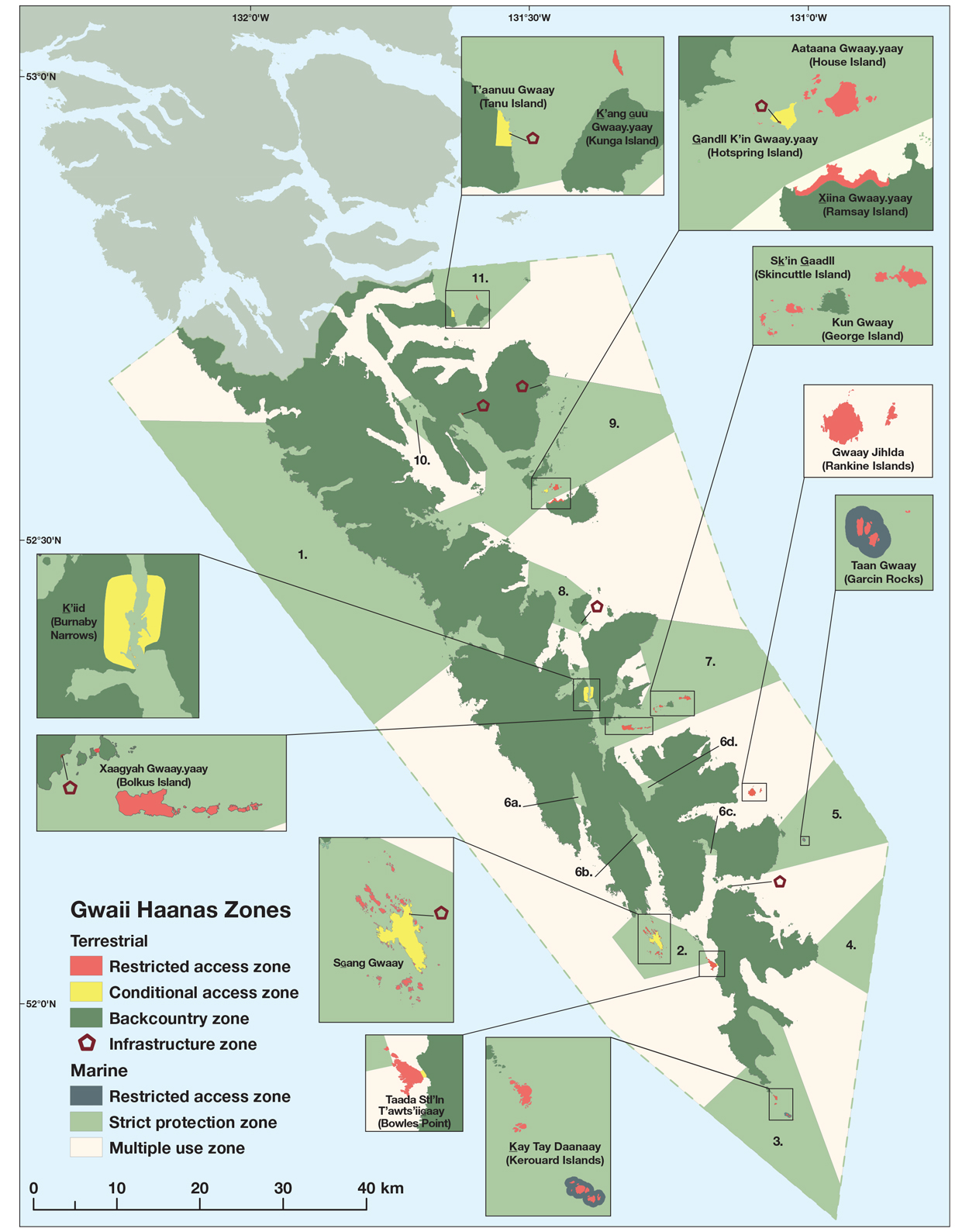
Please see the Gwaii Haanas Gina ’Waadluxan KilGuhlGa Land-Sea-People Management Plan 2018 for full details of these zones and restrictions.
It is your responsibility to be aware of and respect national park regulations (Parks Canada)
- Date modified: