
BC tidal area 15 - Powell River, Texada Island: Bivalve shellfish contamination information
Eating contaminated shellfish can make you very sick and can even be life threatening.
Harvesting opportunities and closures change often throughout the year for conservation or public health reasons. Check the table below or our real-time bivalve shellfish safety harvesting map to ensure that it's legal and safe to harvest, every time you head out to fish. If you are a recreational harvester, you also need to review recreational shellfish harvesting opportunities and limits and ensure you are carrying a current tidal waters sport fishing licence.
Because of the risk of sanitary contamination, all bivalve shellfish harvesting is permanently closed within the following boundaries, often marked with signage or red concrete markers:
- 300 metres around industrial, municipal and sewage treatment plant outfall discharges
- 125 metres around a marina, ferry wharf, floating living accommodation, or any finfish net pen
If you are in an aquaculture facility there are some exceptions to the second item.
- 25 metres around any floating living accommodation facility located within a shellfish aquaculture facility where a zero-discharge and appropriate waste management plan is a condition of the Aquaculture Licence and is approved by the Regional Interdepartmental Committee
- 0 metres of any finfish net pen within an aquaculture facility where an Integrated Multi-Trophic Aquaculture Management Plan approved by the Regional Interdepartmental Committee is in operation.
Shellfish aquaculture facilities use markers at the corners of their licensed area.
Bivalve shellfish contamination status
Look at the first column below to see which species are safe to harvest. If there is information in the second column, it is both illegal and unsafe to harvest any bivalve species in those areas.
| Subarea | Marine biotoxin update (open bivalve species) | Sanitary contamination closures (closed to shellfish harvesting) |
|---|---|---|
| 15-1 | Clam - Littleneck;Clam - Manila;Mussels - all species combined;Oyster - Pacific | |
| 15-2 | Geoduck;Clam - Horse;Clam - Littleneck;Clam - Manila;Mussels - all species combined;Oyster - Pacific | |
| 15-3 | Geoduck;Clam - Horse;Clam - Littleneck;Clam - Manila;Mussels - all species combined;Oyster - Pacific | |
| 15-4 | Clam - Littleneck;Clam - Manila;Mussels - all species combined;Oyster - Pacific | |
| 15-5 |
|
|
| 15-6 | Closed to All Bivalve Species |
Last updated: 2026-07-20
Area descriptions
| Closure | Map | Area description |
|---|---|---|
| 15.1 Klahanie to Myrtle Creek, Malaspina Strait | 15.1.png | The intertidal foreshore of Malaspina Strait, near the city of Powell River, commencing at a large log buried in the foreshore south of Scuttle Bay at 49°53.86' north latitude and 124°37.24' west longitude, thence southeasterly along the intertidal foreshore to the mouth of Myrtle Creek at 49°47.68' north latitude and 124°28.79' west longitude. [NAD83] |
| 15.11 Frolander Bay | 15.11.png | The waters and intertidal foreshore of Frolander bay located inside a line drawn from the headland at 49°45.65' north latitude and 124°17.99' west longitude, thence easterly to a headland on the opposite shore at 49°45.68' north latitude and 124°17.70' west longitude. [NAD83] |
| 15.13 Northwest Refuge Cove | 15.13.png | The waters and intertidal foreshore of Refuge Cove, West Redonda Island, lying inside a radius of 125 metres of the private dock located at 50°07.61' north latitude and 124°50.94' west longitude. [NAD83] |
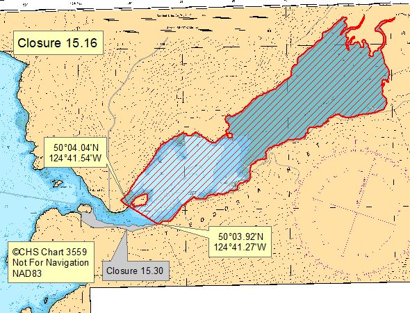
| 15.16 Theodosia Inlet | 15.16.png | The waters and intertidal foreshore of Theodosia Inlet, east of a line drawn across the narrow entrance from a point of land at 50°04.04' north latitude and 124°41.54' west longitude, located east of Galahad Point, thence southeasterly to a point on land on the opposite shore at the mouth of a seasonal creek located at 50°03.92' north latitude and 124°41.27' west longitude. [NAD83] |
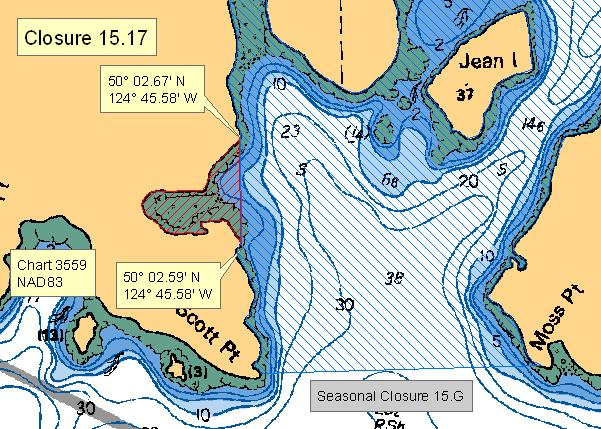
| 15.17 Portion of Grace Harbour | 15.17.png | The waters and intertidal foreshore of the small cove northwest of the entrance to Grace Harbour, Malaspina Inlet, west of a line drawn from the headland at 50°02.59' north latitude and 124°45.58' west longitude, thence northerly to the headland on the opposite shore at 50°02.67' north latitude and 124°45.58' west longitude. [NAD83] |
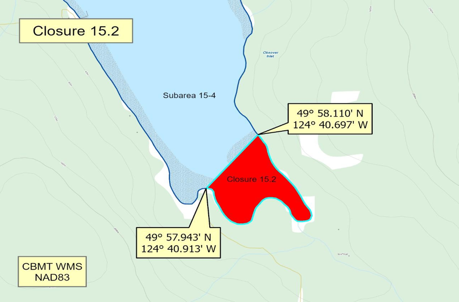
| 15.2 Freke Anchorage, Okeover Inlet | 15.2.png | The waters and intertidal foreshore of that portion of Subarea 15-4 inside a line that commences at 49°58.110'N,124°40.697'W [head of Freke Anchorage, Okeover Inlet], then following the shoreline southwesterly to 49°57.943'N, 124°40.913'W [Okeover Inlet], then northeasterly to the point of commencement. [NAD83] |
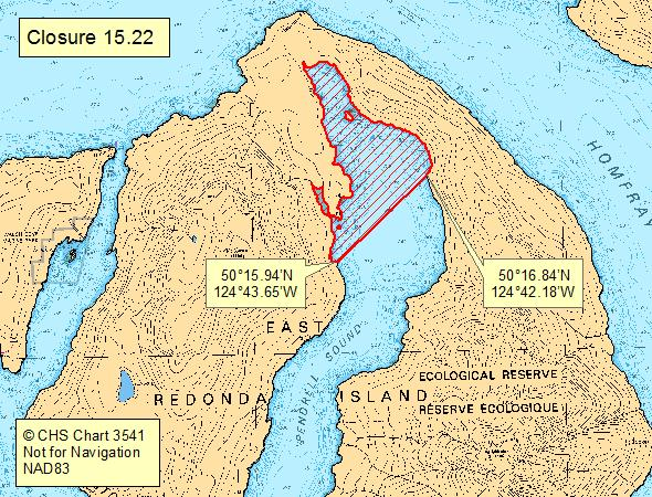
| 15.22 The head of Pendrell Sound, East Redonda Island | 15.22.png | The waters and intertidal foreshore of the head of Pendrell Sound, East Redonda Island, north of a line drawn from the unnamed point of land at 50°15.94' north latitude and 124°43.65' west longitude, thence northeasterly to an unnamed point of land on the opposite shore at 50°16.84' north latitude and 124°42.18' west longitude. [NAD83] |
| 15.26 Malaspina Strait, Powell River | 15.26.png | The subtidal waters off Powell River, seaward of Sanitary Closure 15.1, inside a line commencing at Grief Point at 49°48.25' north latitude and 124°31.59' west longitude, thence northwesterly to a point in water at 49°48.67' north latitude and 124°33.42' west longitude, thence northwesterly to a point in water north of Harwood Island at 49°53.86' north latitude and 124°38.50' west longitude, thence easterly to the large log buried in the foreshore south of Scuttle Bay at 49°53.86' north latitude and 124°37.24' west longitude, thence southeasterly following the outer boundary of Sanitary Closure 15.1 back to the point of commencement. [NAD83] |
| 15.27 Harwood Island | 15.27.png | The intertidal foreshore of southwestern Harwood Island inside a line drawn from the southernmost point of the offshore islet at 49°50.67' north latitude and 124°40.49' west longitude, thence true easterly to a point on land at 49°50.67' north latitude and 124°40.25' west longitude, thence southerly along the high tide mark to a point of land at 49°50.33' north latitude and 124°40.30' west longitude, thence northwesterly along the low tide mark to the point of commencement. [NAD83] |
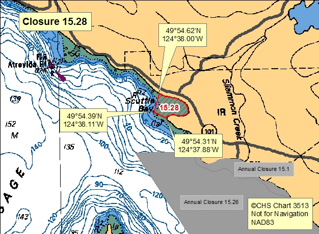
| 15.28 Scuttle Bay | 15.28.png | The waters and intertidal foreshore of Scuttle Bay east of a line drawn from the headland at the south end of Scuttle Bay at a pair of fir trees at 49°54.31' north latitude and 124°37.88' west longitude, thence northwesterly to the edge of the shoal at 49°54.39' north latitude and 124°38.11' west longitude, thence northeasterly to a small rock jetty at 49°54.62' north latitude and 124°38.00' west longitude. [NAD83] |
| 15.29 Refuge Cove, West Redonda Islands | 15.29.png | The waters and intertidal foreshore of Refuge Cove, West Redonda Island, lying northeast of a line drawn across the entrance to the small cove from a point of land at 50°07.57' north latitude and 124°50.81' west longitude, thence southeasterly to the headland on the opposite shore at 50°07.51' north latitude and 124°50.66' west longitude. [NAD83] |
| 15.3 Lund Wastewater Treatment Plant | 15.3.jpeg | The waters and intertidal foreshore surrounding Lund Harbour and Finn Cove within a radius of 1,680 metres of the Lund wastewater pump station located at or near 49°58.86' north latitude and 124°45.72' west longitude, extending northwesterly along the shore of Malaspina Peninsula to 49°59.51' north latitude and 124°46.70' west longitude, and southeasterly along the shore of Malaspina Peninsula to 49°58.00' north latitude and 124°45.28' west longitude. [NAD83] |
| 15.30 Southern entrance to Theodosia Inlet | 15.30.jpeg | The waters and intertidal foreshore at the south entrance of Theodosia Inlet, within a portion of Subarea 15-4, south of a line drawn from a point [on land] at 50°04.086'N, 124°41.823'W, thence southwesterly to a point [on land] at 50°04.045'N,124°41.919'W, thence following the shoreline easterly to a point [on land] at 50°03.924'N, 124°41.276' W, and thence northwesterly to a point [on land] at 50°04.017'N, 124°41.504'W. [NAD 83] |
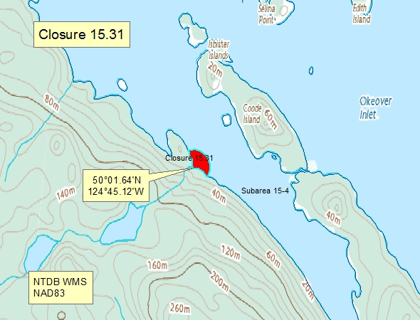
| 15.31 Western Trevenen Bay | 15.31.png | The waters and intertidal foreshore of western Trevenen Bay within a 125 m radius centered at the mouth of the creek at 50°01.64' north latitude and 124°45.12' west longitude. [NAD83] |
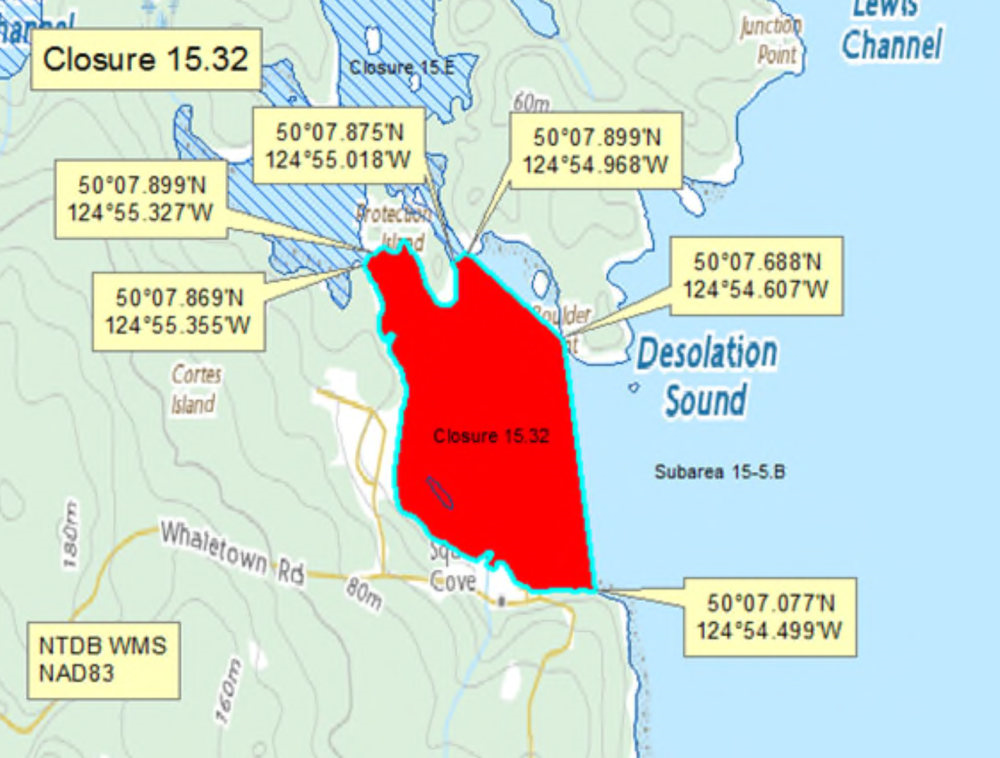
| 15.32 Squirrel Cove, Cortes Island | 15.32.png | The waters and intertidal foreshore of Lewis Channel in Squirrel Cove lying inside of a line drawn from a point on land on Cortes Island at 50°07.975' north latitude and 124°55.840' west longitude, northeasterly to a point on land on Protection Island at 50°08.133' north latitude and 124°55.306' west longitude, thence following the high tide mark easterly to a point on land at 50°07.875' north latitude and 124°55.018' west longitude, thence northeasterly to a point of land on Cortes Island at 50°07.899' north latitude and 124°54.968' west longitude, thence following the high tide mark easterly to a point on land at 50°07.891' north latitude and 124°54.951' west longitude, thence southeasterly to a point on land on Cortes Island at 50°07.688' north latitude and 124°54.607' west longitude, thence southeasterly to a point on land on Cortes Island at 50°07.077' north latitude and 124°54.499' west longitude, thence following the high tide mark westerly to the point of commencement. [NAD83] |
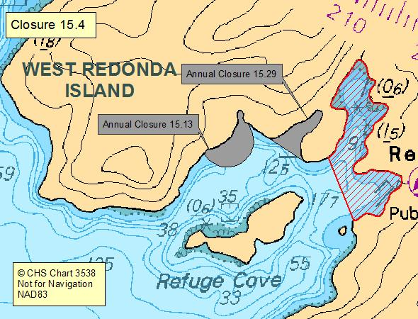
| 15.4 East Refuge Cove | 15.4.png | The waters and intertidal foreshore of Refuge Cove, west Redonda Island lying inside a line drawn across the head of the cove, from a point on the north foreshore 400 m from the centre of the bulk oil storage tank situated near the head of the cove, to a point on the south foreshore 275 m from the centre of the bulk oil storage tank. |
| 15.5 Lang Bay | 15.5.png | The waters and intertidal foreshore of Lang Bay located inside a line drawn from the eastern headland of Kelly Point at 49°46.28' north latitude and 124°21.93' west longitude, thence easterly to the point at 49°46.15' north latitude and 124°20.67' west longitude. [NAD83] |
| 15.6 Bliss Landing | 15.6.png | The waters and intertidal foreshore of the two unnamed coves at Bliss Landing located at the north end of Turner Bay, Malaspina Peninsula, lying inside a line drawn from the southern headland at 50°02.28' north latitude and 124°49.22' west longitude thence westerly to the shoal at 50°02.26' north latitude and 124°49.38' west longitude thence northerly to a point on the opposite mainland shore at 50°02.44' north latitude and 124°49.38' west longitude. [NAD83] |
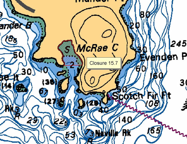
| 15.7 McRae Cove | 15.7.png | The waters and foreshore of McRae Cove lying inside a line drawn due east from the western headland of the cove to the opposite shore. |
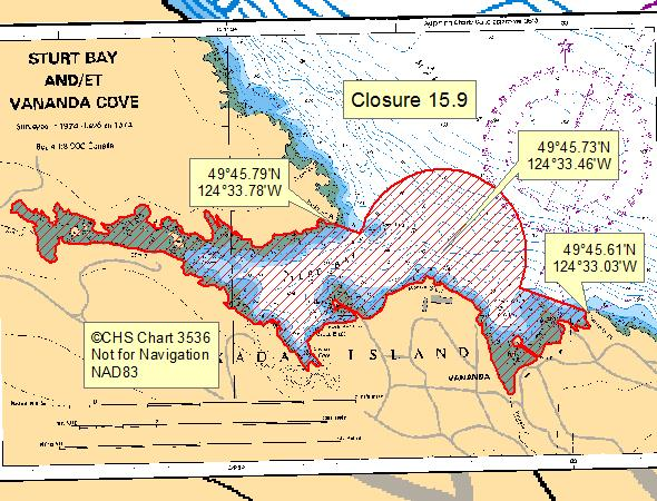
| 15.9 Sturt Bay and Van Anda Cove | 15.9.png | The waters and intertidal foreshore of Sturt Bay and Van Anda Cove, northeast Texada Island, south of a line drawn from Hodgson Point at 49°45.79' north latitude and 124°33.78' west longitude, thence southeasterly to Van Anda Point at 49°45.61' north latitude and 124°33.03' west longitude plus a 300 m radius around the Texada school wastewater discharge pipe located at or near 49°45.73' north latitude and 124°33.46' west longitude. [NAD83] |
| 15.A Prideaux Haven | 15.A.png | The waters and intertidal foreshore of that portion of Subarea 15-5.C inside a line that commences at 50°08.804'N, 124°41.067'W [Scobell Island], then following the shoreline easterly to 50°08.840'N, 124°40.767'W [Scobell Island], then easterly to 50°08.851'N, 124°40.139'W [Copplestone Point], then following the shoreline southwesterly to 50°08.358'N, 124°04.573'W [Melanie Cove], then northerly to 50°08.397'N, 124°51.595'W [Everleigh Island], then following the shoreline northeasterly to 50°08.722'N, 124°41.138'W [Everleigh Island], then northeasterly to the point of commencement. [NAD83] |
| 15.B Tenedos Bay | 15.B.png | The waters and intertidal foreshore of that portion of Subarea 15-5.B inside a line that commences at 50°07.050'N, 124°42.439'W [Tenedos Bay], then following the shoreline northerly to 50°07.281'N, 124°41.779'W [Tenedos Bay], then southwesterly to the point of commencement. [NAD83] |
| 15.C Allies Island, West Redonda Island | 15.C.png | The waters and intertidal foreshore of that portion of Subarea 15-5.C inside a line that commences at 50°12.791'N, 124°48.840'W [unnamed islet], then easterly to 50°12.791'N, 124°48.801'W [Allies Island], then following the shoreline southeasterly to 50°05.579'N, 124°48.471'W [Allies Island], then southwesterly to 50°12.532'N, 124°48.546°W [West Redonda Island], then following the shoreline northwesterly to 50°12.738'N, 124°48.884'W [West Redonda Island], then northerly to 50°12.757'N, 124°48.877'W [unnamed islet], then following the shoreline northeasterly to the point of commencement. [NAD83] |
| 15.D Roscoe Bay, West Redonda Island | 15.D.png | The waters and intertidal foreshore of that portion of Subarea 15-5.C inside a line that commences at 50°09.787'N, 124°45.122'W [Roscoe Bay, West Redonda Island], then southerly to 50°09.694'N, 124°45.091'W [Marylebone Point, West Redonda Island], then following the shoreline westerly to the point of commencement. [NAD83] |
| 15.E Squirrel Cove, Cortes Island | 15.E.png | The waters and intertidal foreshore of that portion of Subarea 15-5.B inside a line that commences at 50°07.974'N, 124°55.841'W [Squirrel Cove, Cortes Island], then following the shoreline northerly to 50°07.898'N, 124°54.969'W [Cortes Island], then southwesterly to 50°07.874'N, 124°55.186'W [Protection Island], then following the shoreline northerly to 50°08.134'N, 124°55.307'W [Protection Island], then southwesterly to the point of commencement. [NAD83] |
| 15.F Cortes Bay, Cortes Island | 15.F.png | The waters and intertidal foreshore of that portion of Subarea 15-3 inside a line that commences at 50°03.814'N, 124°55.498'W [Cortes Bay, Cortes Island], then southerly to 50°03.746'N, 124°55.455'W [Cortes Bay, Cortes Island], then northwesterly to the point of commencement. [NAD83] |
| 15.G Grace Harbour | 15.G.png | The waters and intertidal foreshore of that portion of Subarea 15-4 inside a line that commences at 50°02.488'N, 124°45.563'W [Scott Point, Grace Harbour, Gifford Peninsula], then following the shoreline northerly to 50°02.297'N, 124°04.582'W [Grace Harbour, Gifford Peninsula], then northerly to 50°02.664'N, 124°45.580'W [Grace Harbour, Gifford Peninsula], then following the shoreline northerly to 50°02.488'N, 124°45.237'W [Moss Point, Grace Harbour, Gifford Peninsula], then west to the point of commencement. [NAD83] |
| 15.H Mink Island | 15.H.png | The waters and intertidal foreshore of that portion of Subarea 15-5.B inside a line that commences at 50°06.402'N, 124°45.191'W [Mink Island], then south to 50°06.205'N, 124°45.191'W [Mink Island], then following the shoreline westerly to the point of commencement. [NAD83] |
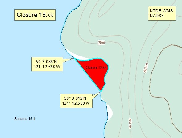
| 15.kk Lancelot Inlet | 15.kk.png | The waters and intertidal foreshore of the cove located south of Bunster Point in Lancelot Inlet, inside a line drawn from a point on land at 50°3.088' north latitude and 124°42.650' west longitude, thence southeasterly to a point on land at 50°3.012' north latitude and 124°42.559' west longitude. [NAD83] |
| 15-5.A | 15-5.A.png | That portion of Subarea 15-5 south of a line drawn from a point on the northwest shoreline of Raza Island at 50°18.26' north latitude and 124°58.10' west longitude, thence easterly to a point on the west coast of West Redonda Island at 50°18.12' north latitude and 124°55.48' west longitude, thence southerly following the shoreline of West Redonda Island to a point at 50°12.29' north latitude and 124°56.55' west longitude, thence southwesterly to a point on the northeast coast of Cortes Island at 50°11.74' north latitude and 124°56.94' west longitude, thence northwesterly following the shoreline of Cortes Island to Bullock Bluff, thence true north following the boundary line to Raza Island, and thence following the shoreline northeasterly back to the point of commencement. |
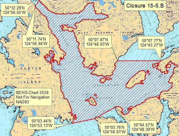
| 15-5.B | 15-5.B.png | That portion of Subarea 15-5 southeast of a line drawn from an unnamed point on the east coast of Cortes Island at 50°11.74' north latitude and 124°56.94' west longitude, thence northeasterly to a point on the west coast of West Redonda Island at 50°12.29' north latitude and 124°56.55' west longitude, thence southerly and then northerly following the shoreline of West Redonda Island to a point on the southeast shoreline of West Redonda Island at 50°07.87' north latitude and 124°48.03' west longitude, thence easterly to a point on the mainland at 50°07.77' north latitude and 124°43.27' west longitude, thence southerly following the shoreline to Zephine Head at 50°04.57' north latitude and 124°48.30' west longitude, then southwesterly following the boundary line to Sarah Point at 50°03.76' north latitude and 124°50.61' west longitude, thence following the boundary line to Mary Point at 50°03.44' north latitude and 124°53.13' west longitude, thence northerly following the eastern shoreline of Cortes Island back to the point of commencement. |
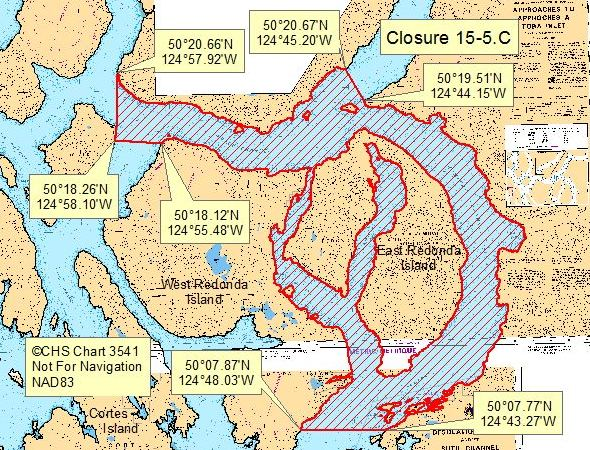
| 15-5.C | 15-5.C.png | That portion of Subarea 15-5 north of a line drawn from a point on West Redonda Island at 50°18.12' north latitude and 124°55.48' west longitude, thence westerly to a point on the east coast of Raza Island at 50°18.26' north latitude and 124°58.10' west longitude, thence northerly to a point on George Head on the mainland at 50°20.66' north latitude and 124°57.92' west longitude, thence easterly following the shoreline to 50°20.67' north latitude and 124°45.20' west longitude, thence southeasterly following the boundary line to Brettell Point at 50°19.51' north latitude and 124°44.15' west longitude, thence southerly following the shoreline to a point at 50°07.77' north latitude and 124°43.27' west longitude, thence westerly to point on the southeast shore of West Redonda Island at 50°07.87' north latitude and 124°48.03' west longitude, thence northerly and westerly following the shoreline of West Redonda Island back to the point of commencement. |
Last updated: 2026-07-20
Related links
- Area maps
- Realtime bivalve shellfish safety harvesting map
- Information about recreational shellfish harvesting in BC
- Shellfish harvesting safety information
- Planned bivalve shellfish harvesting closures
- Identify your catch
Contact us
Email: DFO.PACCSSP-PCAMPAC.MPO@dfo-mpo.gc.ca
- Date modified: