
Planned bivalve shellfish harvesting closures
Eating contaminated shellfish can make you very sick and can even be life threatening. As well as our regular monitoring program, planned harvest closures are put in place to reduce the risk of harvesting and eating contaminated bivalve shellfish.
Seasonal closures: We know that some areas are more likely to be unsafe to harvest from at certain times of the year. These areas are closed to harvesting during these periods. Check the table below for the times and areas of these closures.
Conditional Management Plan closures: Conditional Management Plan (CMP) closures are put in place after an event takes place that may make bivalve shellfish unsafe to eat.
- Excess rainfall: Significant rainfall can cause overflows of sewage treatment and collection systems, as well as other pollution resulting from surface runoff from land. Shellfish in adjacent waters can be contaminated from such discharges and pose a risk to human health if they are consumed. Emergency closures due to rainfall remain in effect for a minimum of seven days to allow proper cleansing of shellfish.
- Wastewater treatment plant discharge: CMP closures are also put in place in areas that may have unsafe bivalve shellfish when there is a sewage overflow at a nearby wastewater treatment plant These areas are reopened to harvesting when it is safe to do so.
Planned harvesting closures
It is illegal and unsafe to harvest any bivalve shellfish species in the areas and times stated below. If the area or time that you are intending to harvest from is not listed below, make sure to check the specific area page to see what is safe to harvest.
| Closure date | Closure | Map | Description |
|---|---|---|---|
| 05310930 May 31 - Sept 30 | 28.B Indian Arm, Burrard Inlet | Subarea: 02-14
Map: Closure 28.B |
Subarea 28-14 described as the head of Indian Arm north of a line drawn from a point on land at Iron Bay at 49°27.464’ north latitude and 122°52.246’ west longitude, thence in a westerly direction to a point on land on the opposite shore south of the Wigwam Inn at 49°27.420’ north latitude and 122°53.100’ west longitude. [NAD 83] |
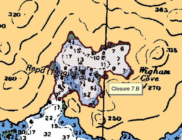
| 05310930May 31 to Sep 30 | 07.B Wigham Cove, Yeo Island | Subarea: 07-15
Map: Closure 07.B |
The waters and intertidal foreshore of Wigham Cove, Yeo Island, inside a line drawn from the headland at the eastern end of the cove entrance at 52° 16.64' north latitude and 128° 10.40' west longitude, thence west to the opposite shore at 52° 16.64' north latitude and 128° 10.51' west longitude. [NAD 27] |
| 05310930May 31 to Sep 30 | 09.A Clam Bay, Penrose Island | Subarea: 09-1
Map: Closure 09.A |
The waters and intertidal foreshore of the unnamed bay, locally known as Clam Beach, located on the west side of Penrose Island, lying inside a line drawn from a point on land at 51° 29.25' north latitude and 127° 45.90' west longitude thence south to the westernmost point on the small unnamed island, thence southeast to the headland on Fury Island at 51° 29.10' north latitude and 127° 45.80' west longitude, thence east along the high water mark to the easternmost point of Fury Island at 51° 29.07' north latitude and 127° 45.35' west longitude, thence northeasterly to a point on the opposite shore at 51° 29.10' north latitude and 127° 45.28' west longitude. [NAD 83] |
| 05310930May 31 to Sep 30 | 12.A Cutter Cove | Subarea: 12-26
Map: Closure 12.A |
The waters and intertidal foreshore of Cutter Cove lying east of a line drawn from the southern headland of the cove, thence northerly to the westernmost point on the northern headland. |
| 05310930May 31 to Sep 30 | 13.B Von Donop Inlet, Cortes Island | Subarea: 13-17
Map: Closure 13.B |
The waters and intertidal foreshore of Von Donop Inlet, Cortes Island. |
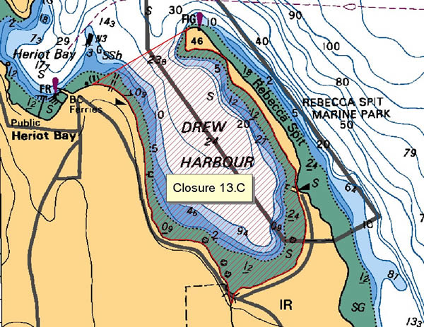
| 05310930May 31 to Sep 30 | 13.C Drew Harbour, Quadra Island | Subarea: 13-13
Map: Closure 13.C |
The waters and intertidal foreshore of Drew Harbour, Quadra Island, lying inside a straight line drawn from the northernmost tip of Rebecca Spit across the entrance of Drew Harbour to its western headland. |
| 07010915July 1 – Sept 15 | 13.F Western Gorge Harbour, Cortes Island | Subarea: 13-15
Map: Closure 13.F |
The waters and intertidal foreshore of western Gorge Harbour, Cortes Island lying west of a line drawn from the base of the marina boat ramp at 50°06.04’ north latitude and 125°01.45’ west longitude, thence in a southwesterly direction to a point of land on the opposite shore at 50°05.93’ north latitude and 125°01.72’ west longitude during the period July 1 to September 15 each year. [NAD83] |
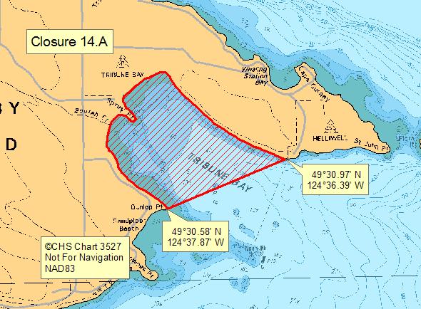
| 05310930May 31 to Sep 30 | 14.A Tribune Bay, Hornby Island | Subarea: 14-7
Map: Closure 14.A |
The waters and intertidal foreshore of Tribune Bay, Hornby Island, lying inside of a line from Dunlop Point on the southwest shore at 49°30.58’ north latitude and 124°37.87’ west longitude thence northeasterly to a point on land at 49°30.97’ north latitude and 124°36.39’ west longitude. [NAD 83]. |
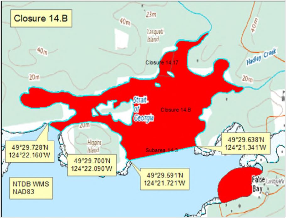
| 05310930May 31 to Sep 30 | 14.B False Bay, Lasqueti Island | Subarea: 14-3
Carte : Secteur 14,B |
The waters and intertidal foreshore of False Bay, Lasqueti Island, lying north of a line drawn from a point of land on the southeast side of Higgins Island at 49°29.591’ north latitude and 124°21.721’ west longitude, thence northeasterly to a point on land on Lasqueti Island at 49°29.638’ north latitude and 124°21.341’ west longitude, thence following the high tide mark of the Lasqueti Island shoreline beginning in a northerly and westerly direction to point on land at 49°29.728’ north latitude and 124°22.160’ west longitude, thence southeasterly to a point on land on the northwest side of Higgins Island at 49°29.700’ north latitude and 124°22.090’ west longitude, thence easterly and southerly following the high tide mark back to the point of commencement. [NAD 83]. |
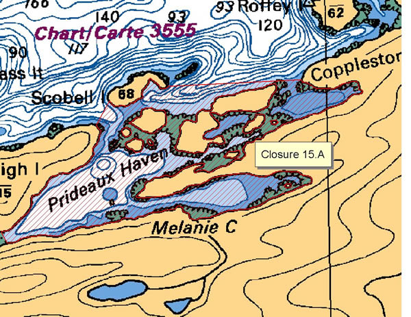
| 05310930May 31 to Sep 30 | 15.A Prideaux Haven | Subarea: 15-5.C
Map: Closure 15.A |
The waters and intertidal foreshore of the area known as Prideaux Haven, including Melanie Cove and Laura Cove, bounded on the west by a line drawn along the shortest distance from Eveleigh Island to the shore of the mainland and on the north by a line drawn from Lucy Point on Eveleigh Island to the westernmost tip of Scobell Island and thence from the easternmost tip of Scobell Island to Copplestone Point. |
| 05310930May 31 to Sep 30 | 15.B Tenedos Bay | Subarea: 15-5.B
Map: Closure 15.B |
The waters and intertidal foreshore of Tenedos Bay lying inside a line drawn from the eastern tip of Bold Head northeast to the southern headland of the easternmost bay of Tenedos Bay. |
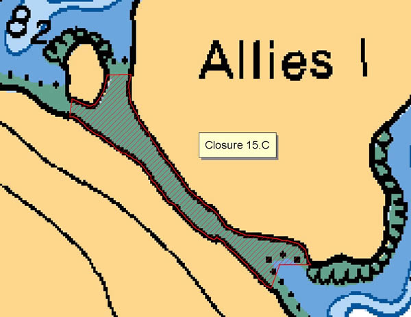
| 05310930May 31 to Sep 30 | 15.C Allies I. - West Redonda Island | Subarea: 15-5.C
Map: Closure 15.C |
The waters and intertidal foreshore lying between Allies Island and west Redonda Island. |
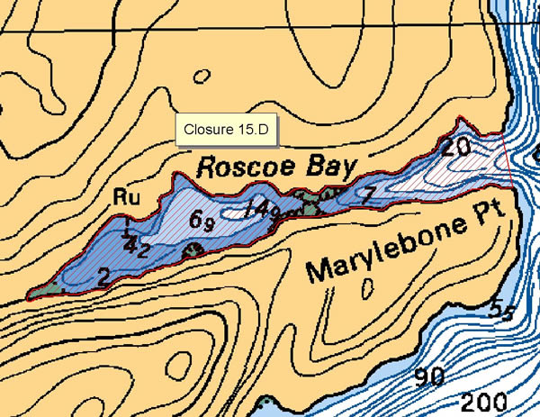
| 05310930May 31 to Sep 30 | 15.D Roscoe Bay, West Redonda Island | Subarea: 15-5.C
Map: Closure 15.D |
The waters and intertidal foreshore of Roscoe Bay, west Redonda Island. |
| 05310930May 31 to Sep 30 | 15.E Squirrel Cove, Cortes Island | Subarea: 15-5.B
Map: Closure 15.E |
The waters and intertidal foreshore of Squirrel Cove, Cortes Island, lying inside a line drawn along the shortest distance from the western shore of Protection Island to Cortes Island and inside a line drawn along the shortest distance from the eastern shore of Protection Island to Cortes Island. |
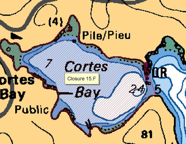
| 05310930May 31 to Sep 30 | 15.F Cortes Bay, Cortes Island | Subarea: 15-3
Map: Closure 15.F |
The waters and intertidal foreshore of Cortes Bay, Cortes Island, lying inside a line drawn across the entrance to the bay. |
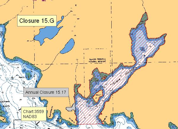
| 05310930May 31 to Sep 30 | 15.G Grace Harbour | Subarea: 15-4
Map: Closure 15.G |
The waters and intertidal foreshore of Grace Harbour lying inside a line drawn from Moss Point to Scott Point, excluding the annual closure 15.17. |
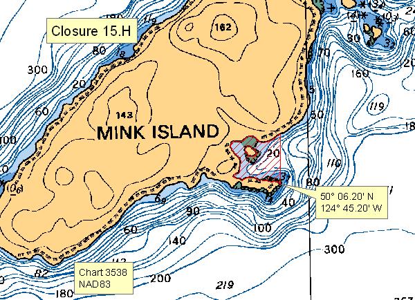
| 05310930May 31 to Sep 30 | 15.H Mink Island | Subarea: 15-5.B
Map: Closure 15.H |
The waters and intertidal foreshore of the prominent bay on the southeast side of Mink Island, Desolation Sound, lying west of a line drawn true north from the point of land at 50°06.20’ north latitude and 124°45.20’ west longitude. |
| 05310930May 31 to Sep 30 | 16.A Smuggler Cove | Subarea: 16-1
Map: Closure 16.A |
The waters and intertidal foreshore of Smuggler Cove lying inside a line drawn from the Smuggler Cove Marine Park sign at the entrance to the cove to the opposite shore. |
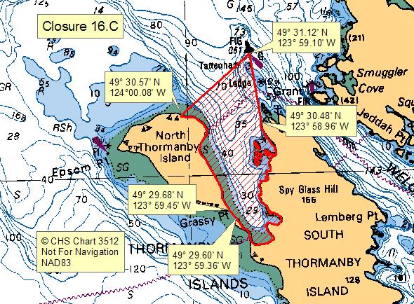
| 05310930May 31 to Sep 30 | 16.C Buccaneer Bay | Subarea: 16-1
Map: Closure 16.C |
The waters and intertidal foreshore of Buccaneer Bay, Thormanby Islands, south of a line drawn from the westernmost unnamed point west of Derby Point on South Thormanby Island at 49°30.48’ north latitude and 123°58.96’ west longitude, thence northerly to the green lateral buoy designated Q51, located at or near 49°31.12’ north latitude and 123°59.10’ west longitude, thence southwesterly to a point on land at the edge of the beach at the base of the cliff on North Thormanby Island at 49°30.57’ north latitude and 124°00.08’ west longitude; and northeast of a line drawn from Grassy Point, North Thormanby Island at 49°29.68’ north latitude and 123°59.45’ west longitude, thence southeasterly to the nearest point of land on South Thormanby Island at 49°29.60’ north latitude and 123°59.36’ west longitude. |
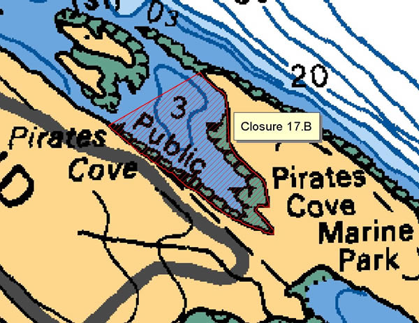
| 05310930May 31 to Sep 30 | 17.B Pirates Cove, De Courcy Island | Subarea: 17-17
Map: Closure 17.B |
The waters and intertidal foreshore of Pirates Cove, De Courcy Island. |
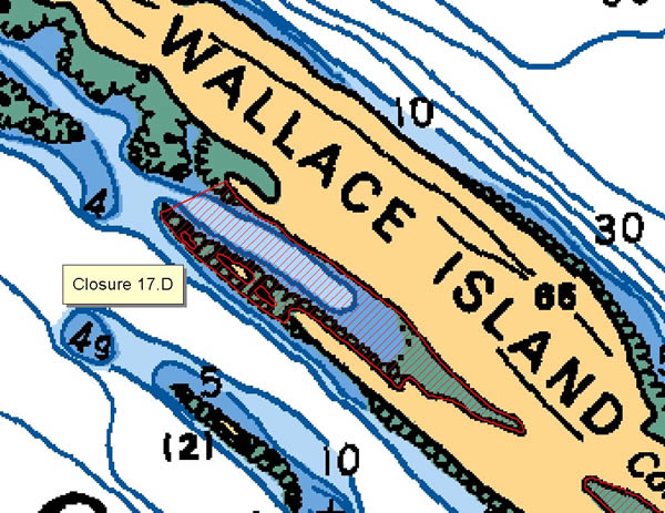
| 05310930May 31 to Sep 30 | 17.D Cove northwest of Conover Cove | Subarea: 17-2
Map: Closure 17.D |
The waters and intertidal foreshore of the cove northwest of Conover Cove, Wallace Island, lying inside a line drawn from the northwesternmost point of the shoal at 48°56.65' north latitude and 123°33.40' west longitude, thence northeasterly to the end of the headland on the opposite shore [NAD 27]. |
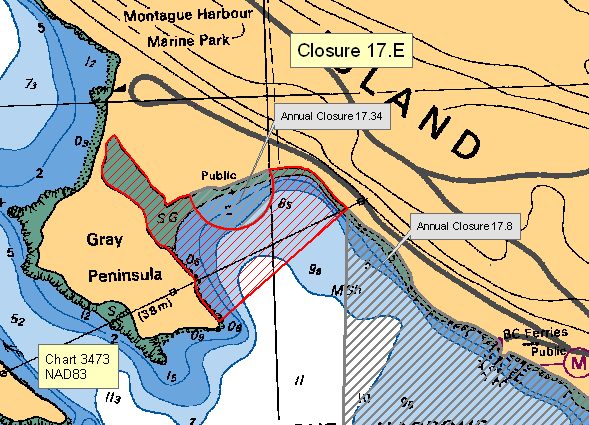
| 05310930May 31 to Sep 30 | 17.E Montague Harbour, Galiano Island | Subarea: 17-2
Map: Closure 17.E |
The waters and intertidal foreshore of Montague Harbour, Galiano Island, inside a line drawn from the southeastern tip of Gray Peninsula northeasterly to the base of the overhead cable tower on the northeastern foreshore of the harbour. |
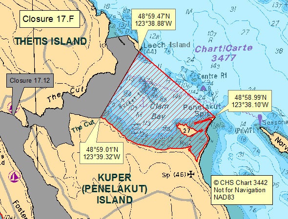
| 05310930May 31 to Sep 30 | 17.F Clam Bay | Subarea: 17-8
Map: Closure 17.F |
The waters and intertidal foreshore of Clam Bay inside of a line drawn from a point on land on Penelakut (Kuper) Island near the entrance to “The Cut” at 48°59.01’ north latitude and 123°39.32’ west longitude northeasterly to the southernmost point of Leech Island at 48°59.47’ north latitude and 123°38.88’ west longitude, thence southeasterly to the tip of Penelakut Spit on Penelakut (Kuper) Island at 48°58.99’ north latitude and 123°38.10’ west longitude, and thence following the shoreline along the high tide mark back to the point of commencement. [NAD83] |
| 05310930May 31 to Sep 30 | 18.A Long Harbour, Saltspring Island | Subarea: 18-3
Map: Closure 18.A |
Long Harbour, Saltspring Island. The waters and intertidal foreshore of Long Harbour, Saltspring Island, east of the Shellfish Sanitary Closure 18.16 boundary to a line drawn across the narrows northwest of the BC Ferries dock, from the northern side of the narrows at 48°51.62' north latitude and 123°27.73' west longitude due south to the southern side of the narrows at 48°51.55' north latitude and 123°27.73' west longitude.[NAD 83] |
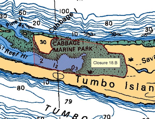
| 05310930May 31 to Sep 30 | 18.B Reef Harbour, Tumbo Island | Subarea: 18-11
Map: Closure 18.B |
The waters and intertidal foreshore of Reef Harbour, lying inside a line drawn from the northeastern tip of Tumbo Island at 48°47.90' north latitude and 123°04.45' west longitude to Cabbage Island thence along the northern shoreline of Cabbage Island to a point at 48°48.00' north latitude and 123°05.25' west longitude, and thence southward to a point on Tumbo Island at 48°47.75' north latitude and 123°05.25' west longitude [NAD 27]. |
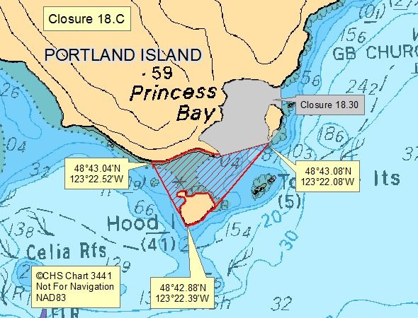
| 05310930May 31 to Sep 30 | 18.C Hood Island | Subarea: 18-6
Map: Closure 18.C |
The waters and intertidal foreshore of Princess Bay located inside a line drawn from the southernmost point of Portland Island at 48°43.04’ north latitude and 123°22.52’ west longitude, thence southeast to the southernmost point of Hood Island at 48°42.88’ north latitude and 123°22.39’ west longitude, thence following the shoreline to the easternmost point of Hood Island, thence northeast to the southernmost point on the unnamed island located north of the Tortoise Islets at 48°43.08’ north latitude and 123°22.08’ west longitude, thence southwest to a point of land on Portland Island at 48°43.05’ north latitude and 123°22.26’ west longitude. [NAD 83] |
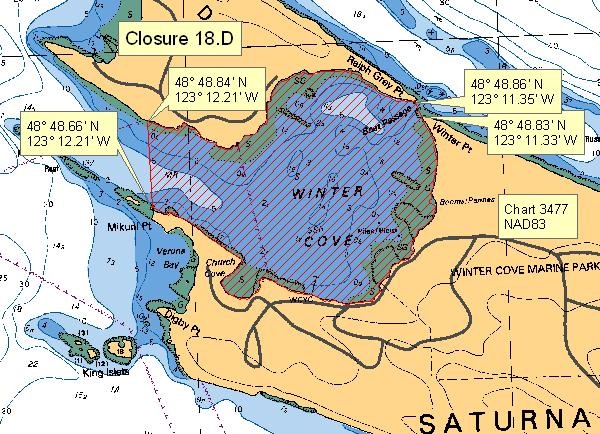
| 05310930May 31 to Sep 30 | 18.D Winter Cove | Subarea: 18-5
Map: Closure 18.D |
The waters and intertidal foreshore of Winter Cove, lying east of a line drawn from Mikuni Point at 48°48.66’ north latitude and 123°12.21 west longitude thence true north to a point on land at 48°48.84 north latitude and 123°12.21 west longitude; and west of a line drawn from Winter Point at 48°48.83 north latitude and 123°11.33 west longitude northerly to Ralph Grey Point at 48°48.86 north latitude and 123°11.35 west longitude. [NAD 83] |
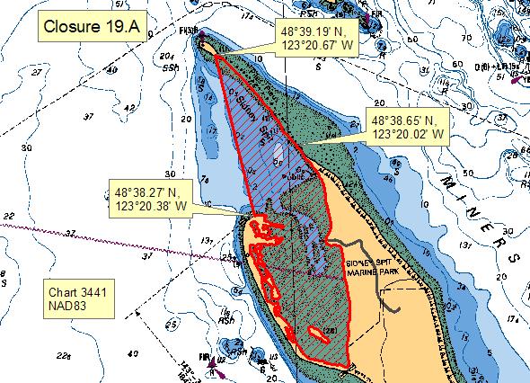
| 05310930May 31 to Sep 30 | 19.A Sidney Spit Marine Park | Subarea: 19-6
Map: Closure 19.A |
Those waters inside a line, representing DFO statistical subarea 19-6, that begins at the end of Sidney Spit at 48° 39.19' north latitude and 123°20.67' west longitude, thence in a southeasterly direction to a point of land on Sidney Island at 48°38.65' north latitude and 123°20.02' west longitude, thence following the shoreline of Sidney Spit Marine Park on Sidney Island to a point on land at 48°38.27' north latitude and 123°20.38' west longitude, thence northerly to the beginning point (NAD 83). |
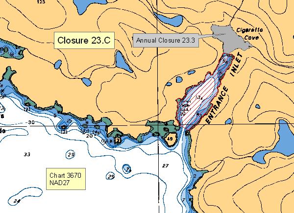
| 05310930May 31 to Sep 30 | 23.C Entrance Inlet | Subarea: 23-9
Map: Closure 23.C |
With the exception of Cigarette Cove at the head of Entrance Inlet, which is closed annually under Sanitary Closure Map 23.3, the waters and intertidal foreshore of Entrance Inlet, lying inside a line drawn across the narrows at the entrance, from a point on land on the west side of the entrance at 49° 00.00' north latitude and 125° 17.78' west longitude, to a point on land on the east side of the entrance at 48° 59.98' north latitude and 125° 17.70' west longitude, thence to the narrows at the boundary on Sanitary Closure Map 23.3, at a line drawn across the narrows from a point on land on the west side at 49° 00.33' north latitude and 125° 17.45' west longitude, to a point on land on the east side at 49° 00.33' north latitude and 125° 17.41' west longitude (NAD 27). |
| 05310930May 31 to Sep 30 | 23.H Robbers Passage | Subarea: 23-5
Map: Closure 23.H |
The waters and intertidal foreshore of Robbers Passage, south of a line drawn from a point of land on Tzartus Island at 48° 53.81' north latitude and 125° 07.00' west longitude due west to a point on land on Fleming Island at 48° 53.81' north latitude and 125° 07.27' west longitude; and north of a line drawn from a point of land on Tzartus Island at 48° 53.64' north latitude and 125° 06.81' west longitude southwesterly to a point of land on Fleming Island at 48° 53.58' north latitude and 125° 06.88' west longitude (NAD83). |
| 05310930May 31 to Sep 30 | 25.A Santa Gertudis Cove, Nootka Island | Subarea: 25-6
Map: Closure 25.A |
The waters and intertidal foreshore of Santa Gertrudis Cove, Nootka Island, inside a line drawn from the point at the southern end of the cove entrance at 49°36.23' north latitude and 126°36.85' west longitude to the point on the northern end of the cove entrance at 49°36.10' north latitude and 126°36.90' west longitude [NAD 27]. |
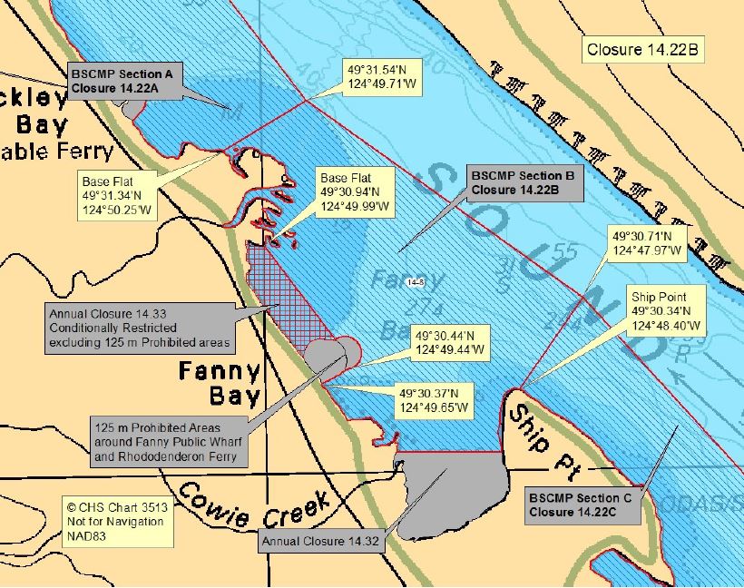
| 0000Conditional Management Plan | 14.22A Baynes Sound CMP | Subareas 14-8, 14-11, 14-15
Map: Closure 14.22A |
The waters and intertidal foreshore of Baynes Sound inside a line commencing at a point on the Vancouver Island shore at the range marker located at the end of Amber Way Road at 49°37.40' north latitude and 124°54.51' west longitude, thence northeasterly to a point in water at 49°37.72' north latitude and 124°54.07' west longitude, thence southeasterly to a point in water at 49°36.01’ north latitude and 124°52.72' west longitude, thence southeasterly to a point in water mid-channel at 49°33.31' north latitude and 124°51.72' west longitude (off Denman Point), thence southeasterly to a point in water off Base Flat at 49°31.54' north latitude and 124°49.71' west longitude, thence southwesterly to a point on land at Base Flat at 49°31.34' north latitude and 124°50.25' west longitude excluding all contamination closures. [NAD 83] |
| 0000Conditional Management Plan | 14.22B Baynes Sound CMP | Subarea 14-8
Map: Closure 14.22B |
The waters and intertidal foreshore of Baynes Sound from a point on land at Base Flat located at 49°31.34’ north latitude and 124°50.25’ west longitude, thence seaward northeasterly to a point in water at 49°31.54’ north latitude and 124°49.71’ west longitude, thence southeasterly to a point in water at 49°30.71’ north latitude and 124°47.97’ west longitude, thence southwesterly to a point on land at Ship Point at 49°30.34’ north latitude and 124°48.40’ west longitude excluding all contamination closures. [NAD 83] |
| 0000Conditional Management Plan | 14.33 Baynes Sound CMP | Subarea 14-8
Map: Closure 14.22B |
The waters and intertidal foreshore of Fanny Bay lying inside a line drawn from a point on land, 125 m south of the Fanny Bay Public Wharf at 49°30.37' north latitude and 124°49.65' west longitude, thence seaward northeasterly to a point in water at 49°30.44' north latitude and 124°49.44' west longitude, thence northwesterly to a point on land at 49°30.94' north latitude and 124°49.99' west longitude excluding the 125 m Prohibited area around the Fanny Bay Public wharf and Rhododenderon Ferry. [NAD 83] |
| 0000Conditional Management Plan | 14.22CBaynes Sound CMP | Subarea 14-8
Map: Closure 14.22C |
The waters and intertidal foreshore of Baynes Sound inside a line commencing at the northern point of Ship Point at 49°30.34’ north latitude and 124°48.40’ west longitude, thence northeasterly to a point in water at 49°30.71’ north latitude and 124°47.97’ west longitude, thence southeasterly to a point in water at 49°28.47’ north latitude and 124°44.95’ west longitude, thence southerly to a point on the Vancouver Island shore at 49°27.74’ north latitude and 124°45.47’ west longitude excluding all contamination closures. [NAD 83] |
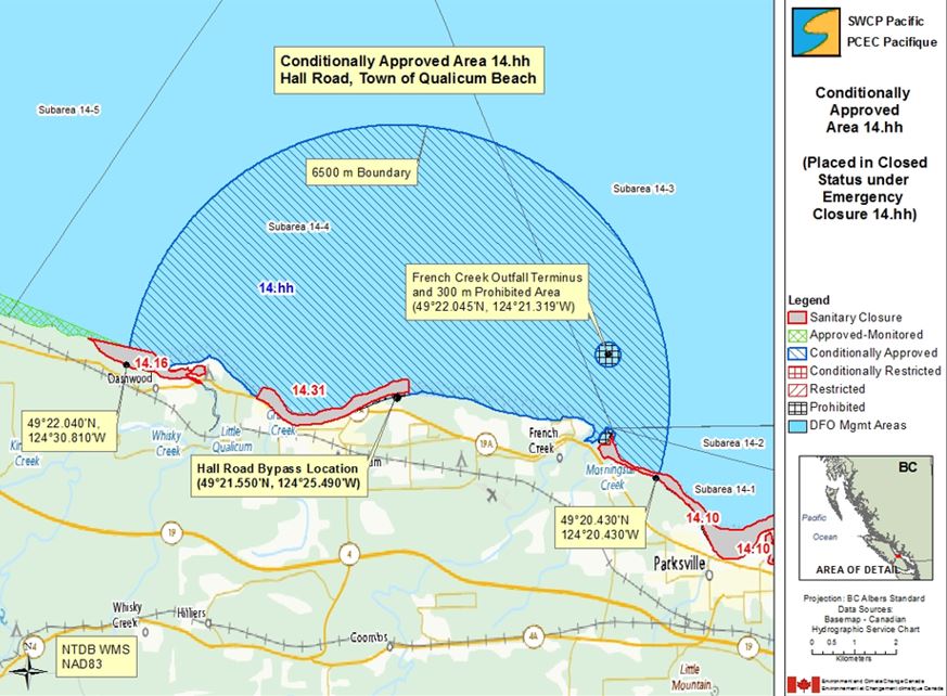
| 0000Conditional Management Plan | 14.hh French Creek CMP | Subareas 14-1 to 14-4
Map: Closure 14.hh |
The waters and intertidal foreshore inside a circular arc with a radius of 6500 m, and excluding the areas already included in Annual Closures, 14.10, 14.16 and 14.31 centered at a point on land at 49°21.550’ north latitude and 124°25.490’ west longitude, which intersects the shoreline at 49°22.040’ north latitude and 124°30.810’ west longitude and again at 49°20.430’ north latitude and 124°20.430’ west longitude, near Hall Road in the Town of Qualicum Beach. [NAD 83] |
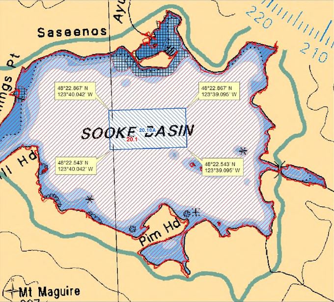
| 0000Conditional Management Plan | 20.10A Sooke Basin Conditional Management Plan | Subarea: 20-7
Map: 20.10A |
Those waters of Sooke Basin inside a line that commences at a point in water at 48°22.867’ north latitude and 123°40.042’ west longitude, then due east in a straight line to a point in water at 48°22.867’ north latitude and 123°39.095’ west longitude, then due south in a straight line to a point in water at 48°22.543’ north latitude and 123°39.095’ west longitude, then due west in a straight line to a point in water at 48°22.543’ north latitude and 123°40.042’ west longitude, then due north to the point of commencement. [NAD 83] |
Related links
- Shellfish harvest area closures related to significant weather events
- Management of shellfish harvesting in areas next to wastewater treatment plants
- Realtime bivalve shellfish safety harvesting map
- BC recreational fishing guide
- Shellfish harvesting safety information
Contact us
Email: DFO.PACCSSP-PCAMPAC.MPO@dfo-mpo.gc.ca.
- Date modified: