
BC tidal area 17 - Nanaimo: Bivalve shellfish contamination information
Eating contaminated shellfish can make you very sick and can even be life threatening.
Harvesting opportunities and closures change often throughout the year for conservation or public health reasons. Check the table below or our real-time bivalve shellfish safety harvesting map to ensure that it's legal and safe to harvest, every time you head out to fish. If you are a recreational harvester, you also need to review recreational shellfish harvesting opportunities and limits and ensure you are carrying a current tidal waters sport fishing licence.
Because of the risk of sanitary contamination, all bivalve shellfish harvesting is permanently closed within the following boundaries, often marked with signage or red concrete markers:
- 300 metres around industrial, municipal and sewage treatment plant outfall discharges
- 125 metres around a marina, ferry wharf, floating living accommodation, or any finfish net pen
If you are in an aquaculture facility there are some exceptions to the second item.
- 25 metres around any floating living accommodation facility located within a shellfish aquaculture facility where a zero-discharge and appropriate waste management plan is a condition of the Aquaculture Licence and is approved by the Regional Interdepartmental Committee
- 0 metres of any finfish net pen within an aquaculture facility where an Integrated Multi-Trophic Aquaculture Management Plan approved by the Regional Interdepartmental Committee is in operation.
Shellfish aquaculture facilities use markers at the corners of their licensed area.
Bivalve shellfish contamination status
Look at the first column below to see which species are safe to harvest. If there is information in the second column, it is both illegal and unsafe to harvest any bivalve species in those areas.
| Subarea | Marine biotoxin update (open bivalve species) | Sanitary contamination closures (closed to shellfish harvesting) |
|---|---|---|
| 17-1 | Closed to All Bivalve Species | |
| 17-2 | Clam - Butter;Clam - Littleneck;Clam - Manila;Mussels - all species combined;Oyster - Pacific |
|
| 17-3 | Clam - Butter;Clam - Littleneck;Clam - Manila;Mussels - all species combined;Oyster - Pacific | |
| 17-4 | Clam - Butter;Cockles;Clam - Littleneck;Clam - Manila;Mussels - all species combined;Oyster - Pacific | |
| 17-5 | Clam - Butter;Cockles;Clam - Littleneck;Clam - Manila;Mussels - all species combined;Oyster - Pacific | |
| 17-6 |
|
|
| 17-7 | Clam - Littleneck;Clam - Manila;Mussels - all species combined;Oyster - Pacific | |
| 17-8 | Clam - Butter;Clam - Littleneck;Clam - Manila;Mussels - all species combined;Oyster - Pacific | |
| 17-9 | Clam - Littleneck;Clam - Manila;Mussels - all species combined;Oyster - Pacific | |
| 17-10 | Clam - Littleneck;Clam - Manila;Mussels - all species combined;Oyster - Pacific | |
| 17-11 | Closed to All Bivalve Species | |
| 17-12 | Clam - Littleneck;Clam - Manila;Mussels - all species combined;Oyster - Pacific | |
| 17-13 | Clam - Littleneck;Clam - Manila;Mussels - all species combined;Oyster - Pacific | |
| 17-14 | Clam - Littleneck;Clam - Manila;Mussels - all species combined;Oyster - Pacific | |
| 17-15 | Closed to All Bivalve Species | |
| 17-16 | Clam - Butter;Clam - Littleneck;Clam - Manila;Mussels - all species combined;Oyster - Pacific | |
| 17-17 | Clam - Littleneck;Clam - Manila;Mussels - all species combined;Oyster - Pacific | |
| 17-18 | Clam - Littleneck;Clam - Manila;Mussels - all species combined;Oyster - Pacific | |
| 17-19 | Clam - Littleneck;Clam - Manila;Mussels - all species combined;Oyster - Pacific | |
| 17-20 | Clam - Littleneck;Clam - Manila;Mussels - all species combined;Oyster - Pacific;Scallop - other;Scallop - Pacific;Scallop - Pink;Scallop - Spiny | |
| 17-21 | Closed to All Bivalve Species |
Last updated: 2026-06-09
Area descriptions
| Closure | Map | Area description |
|---|---|---|
| 17.1 Ladysmith Harbour | 17.1.png | The waters and intertidal foreshore of Ladysmith Harbour lying inside a line drawn from Sharpe Point at 48°58.88' north latitude and 123°46.10' west longitude, thence southeasterly to a point southeast of Boulder Point at the foot of South Oyster School Road at 48°57.49' north latitude and 123°45.35' west longitude. [NAD83] |
| 17.10 Walker Hook, Saltspring Island | 17.10.png | The waters and intertidal foreshore of Walker Hook, Saltspring Island, lying inside a line drawn from the western tip of Walker Hook, thence due south to a point at 48°53.61' north latitude and 123°30.25' west longitude. [NAD83] |
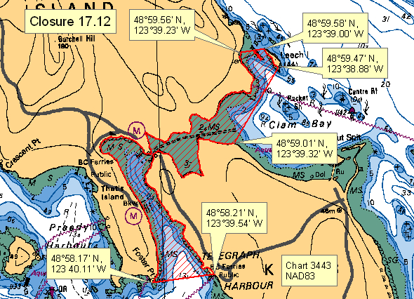
| 17.12 Clam Bay and Telegraph Harbour | 17.12.png | The waters and intertidal foreshore of Clam Bay and Telegraph Harbour, including the boat passage between Thetis Island and Penelakut Island, west of a line drawn from a point on land on Penelakut Island near the entrance to 'The Cut' at 48°59.004' north latitude and 123°39.326' west longitude, thence northeasterly to the southernmost point of Leech Island at 48°59.462' north latitude and 123°38.886' west longitude, thence following the western shoreline of Leech Island to the northernmost point of Leech Island at 48°59.581' north latitude and 123°39.022' west longitude, thence westerly to a point on land on Thetis Island at 48°59.563' north latitude and 123°39.249' west longitude; and east of a line drawn from Foster Point on Thetis Island at 48°58.174' north latitude and 123°40.081' west longitude, to the Penelakut Island public wharf where it touches land at 48°58.215' north latitude and 123°39.540' west longitude. [NAD83] |
| 17.13 Malaview Estates sewage outfall, Saltspring Island | 17.13.png | The intertidal foreshore of Saltspring Island lying 1500 m northwest and 500 m southeast of the Malaview Estates sewage treatment plant outfall sign, southeast of Fernwood Point. [NAD83] |
| 17.16 Taylor Bay, Gabriola Island | 17.16.png | The waters and intertidal foreshore of Taylor Bay, Gabriola Island, lying within a 400 m radius of the most northeastern point of Taylor Bay. [NAD83] |
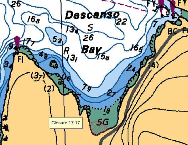
| 17.17 South Side of Descanso Bay, Gabriola Island | 17.17.png | The waters and intertidal foreshore of Descanso Bay, Gabriola Island, lying within a 70 m radius of the culvert entering the southern end of the bay. [NAD83] |
| 17.18 Lantzville | 17.18.png | The intertidal foreshore of Lantzville, from Peterson Road eastward to a point 50 m east of the boat ramp at the Shoregrove Resort. [NAD83] |
| 17.19 Duck Bay, Saltspring Island | 17.19.png | The waters and intertidal foreshore of Duck Bay, Saltspring Island, lying inside, that is eastward, of a line drawn due north from the first headland on the south side of Dock Point to the opposite shore. [NAD83] |
| 17.20 Vesuvius Bay, Saltspring Island | 17.20.png | The waters and intertidal foreshore of the northern shore of Vesuvius Bay, Saltspring Island, from a point on the shore 150 m north of the ferry slip to a point on the shore 500 m southeast of the ferry terminal. [NAD83] |
| 17.21 Booth Bay, Saltspring Island | 17.21.png | The waters and intertidal foreshore of Booth Inlet on the west side of Saltspring Island, east of a line drawn from a point on land at 48°51.960' north latitude and 123°32.795' west longitude southwesterly to a point on land on the opposite shore at 48°51.937' north latitude and 123°32.826' west longitude. [NAD83] |
| 17.22 Porter Creek, Stuart Channel | 17.22.png | The waters and intertidal foreshore lying within a 400 m radius of the mouth of Porter Creek, Stuart Channel. [NAD83] |
| 17.23 Unnamed Bay Northwest Side of Saltspring Island | 17.23.png | The waters and intertidal foreshore of the small unnamed bay located at 48°56.00' north latitude and 123°35.75' west longitude, on the northwest side of Saltspring Island. [NAD83] |
| 17.24 Stone Cutters Bay, Saltspring Island | 17.24.png | The waters and intertidal foreshore of Stone Cutters Bay, Saltspring Island, lying inside of a line drawn due north from the first headland on the south side of Stone Cutters Bay to the opposite shore at 48°55.77' north latitude and 123°35.57' west longitude. [NAD27] |
| 17.25 North Side of Descanso Bay, Gabriola Island | 17.25.png | The waters and intertidal foreshore of Descanso Bay, Gabriola Island, from the point of land on the north side of the bay at 49°10.78' north latitude and 123°51.61' west longitude thence west to a point on the opposite shore at 49°10.80' north latitude and 123°51.67' west longitude. [NAD83] |
| 17.26 Southey Bay, Saltspring Island | 17.26.png | The intertidal foreshore of Southey Bay, Saltspring Island, lying inside a line drawn from the north shore of Southey Bay at 48°56.54' north latitude and 123°35.50' west longitude thence southerly to the south shore at 48°56.50' north latitude and 123°35.55' west longitude. [NAD27] |
| 17.27 Nanoose Harbour, Knarston Creek | 17.27.png | The intertidal foreshore spanning approximately 1.2 nautical miles in the vicinity of Knarston Creek, Nanoose Harbour (a portion of the area between Fleet Point and Blunden Point), bounded on the west by a line drawn from a point on land at 49°15.27' north latitude and 124°07.12' west longitude due north to the low water mark, and bounded on the east by a line drawn from a point on land at 49°15.25' north latitude and 124°05.54' west longitude, true north to the low water mark. [NAD83] |
| 17.3 Chemainus Bay to Shoal Islands | 17.3.png | The waters and intertidal foreshore of Chemainus Bay, the Shoal Islands and Osborn Bay lying inside a line drawn from the outcrop on the northwest side of Askew Creek at 48°56.01' north latitude and 123°43.59' west longitude, thence northeasterly to a point in water at 48°56.19' north latitude and 123°43.41' west longitude, thence southeasterly to the North Reef Light, at 48°54.84' north latitude and 123°37.61' west longitude, thence southerly to a point on land near a line of pilings located westerly of Sherard Point at 48°51.75' north latitude and, 123°37.61' west longitude. [NAD83] |
| 17.30 Winchelsea Islands | 17.30.png | The intertidal foreshore of the Winchelsea Islands. [NAD83] |
| 17.31 Ada Islands | 17.31.png | The intertidal foreshore of the Ada Islands. [NAD83] |
| 17.32 Conover Cove, Wallace Islands | 17.32.png | The waters and intertidal foreshore of Conover Cove, Wallace Island, lying east of a line drawn from the tip of the peninsula at the north end of the entrance at 48°56.21' north latitude and 123°32.71' west longitude southeasterly to the tip of the peninsula at the south end of the entrance at 48°56.17' north latitude and 123°32.66' west longitude. [NAD83] |
| 17.34 Montague Harbour, Galiano Island | 17.34.png | The waters and intertidal foreshore of northwest Montague Harbour, Galiano Island, within 125 m of the point where the public dock meets the land at 48°53.85' north latitude and 123°24.18' west longitude. [NAD83] |
| 17.35 Boat Harbour | 17.35.png | The waters and intertidal foreshore of Boat Harbour inside a line commencing from Flewett Point at 49°05.49' north latitude and 123°47.88' west longitude, thence northwesterly to a point on land at 49°05.54' north latitude and 123°48.11' west longitude. [NAD83] |
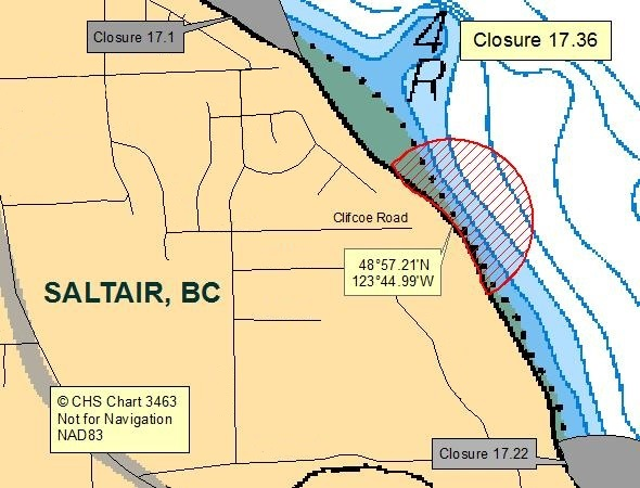
| 17.36 Clifcoe Road, Saltair | 17.36.png | The waters and intertidal foreshore lying within a 250 meter radius of the discharge pipe at the end of Clifcoe Road, Saltair at 48°57.21' north latitude and 123°44.99' west longitude. [NAD83] |
| 17.37 McFadden Creek, Saltspring Island | 17.37.png | The waters and intertidal foreshore lying within a 200 meter radius of McFadden Creek on Saltspring Island at 48°55.65' north latitude and 123°33.59' west longitude. [NAD83] |
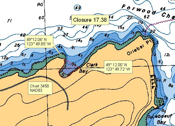
| 17.38 Clark Bay | 17.38.png | The waters and intertidal foreshore of Clark Bay on the north side of Gabriola Island commencing at a point on the western foreshore at 49°12.06' north latitude and 123°49.85' west longitude and thence south-easterly to a point on land at 49°12.00' north latitude and 123°49.72' west longitude. [NAD83] |
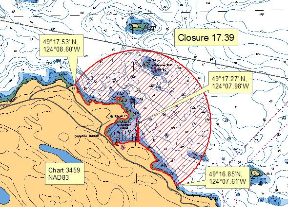
| 17.39 Schooner Cove, Nanoose Wastewater Treatment Plant | 17.39.png | The waters and intertidal foreshore surrounding Schooner Cove within a radius of 900 metres of the seaward end of the Schooner Cove marina breakwater located at or near 49°17.27' north latitude and 124°07.98' west longitude, extending northwesterly along the shore of Vancouver Island to 49°17.53' north latitude and 124°08.60' west longitude, and southeasterly along the shore of Vancouver Island to 49°16.85' north latitude and 124°07.61' west longitude. [NAD83] |
| 17.4 Nanaimo Harbour | 17.4.png | The intertidal foreshore of Newcastle Island from Shaft Point at 49°11.68' north latitude and 123°56.83' west longitude to Nares Point at 49°12.17' north latitude and 123°56.61', and the waters and intertidal foreshore of Nanaimo Harbour and Newcastle Island Passage inside a line that commences at Jack Point at 49°10.00' north latitude and 123°53.68' west longitude, thence to Gallows Point on Protection Island at 49°10.23' north latitude and 123°55.08' west longitude thence following the western shore of Protection Island to Batchelor Point at 49°10.99' north latitude and 123°54.95' west longitude, thence to an unnamed point of land on Newcastle Island at 49°11.38' north latitude and 123°55.34' west longitude, then following the southern shore of Newcastle Island to Shaft Point at 49°11.68' north latitude and 123°56.83' west longitude thence to Pimbury Point 49°11.60' north latitude and 123°56.94' then following the shoreline to the point of commencement at Jack Point. [NAD83] |
| 17.40 Northumberland Channel, Duke Point Wastewater Treatment Plant | 17.40.png | The waters and intertidal foreshore of Northumberland Channel, southwest of a line drawn from Jack Point at 49°09.98' north latitude and 123°53.61' west longitude, to the prominent point of land on Vancouver Island west of Joan Point at 49°08.13' north latitude and 123°49.91' west longitude. [NAD83] |
| 17.41 Hammond Bay | 17.41.png | The waters and intertidal foreshore of Georgia Strait lying inside of a line drawn from a point of land west of Neck Point at 49°14.178' north latitude and 123°58.200' west longitude, thence northeast to a point in water at 49°15.042' north latitude and 123°56.838' west longitude, thence southeast to a point in water east of Five Finger Island at 49°13.890' north latitude and 123°54.865' west longitude, thence southwest to a point in water at 49°12.926' north latitude and 123°56.032' west longitude, thence northwest to a point of land at 49°13.324' north latitude and 123°56.805' west longitude following the high tide mark northwest to the point of commencement. [NAD83] |
| 17.44 Southeast of Icarus Point to west of Neck Point | 17.44.png | The intertidal foreshore from a point on land at 49°14.95' north latitude and 124°02.19' west longitude at Icarus Point following the intertidal boundary southeasterly to a point on land at 49°14.34' north latitude and 123°59.81' west longitude approximately 2.5 km west of Neck Point. [NAD83] |
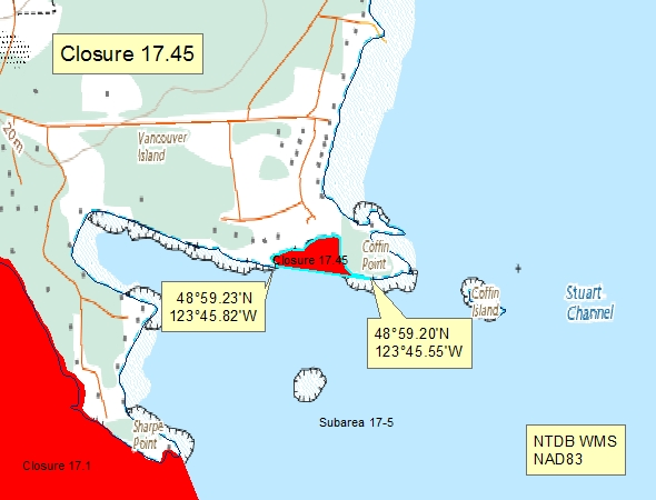
| 17.45 West of Coffin Point, Evening Cove | 17.45.png | The waters and intertidal foreshore of the unnamed bay west of Coffin Point within Evening Cove lying north of a line drawn from a point of land at 48°59.23' north latitude and 123°45.82' west longitude thence southeasterly to a point on land at 48°59.20' north latitude and 123°45.55' west longitude. [NAD83] |
| 17.46 Sansum Narrows, Saltspring Island | 17.46.png | The waters and intertidal foreshore of that portion of Subarea 17-6 inside a line that commences at 48°54.201' N 123°35.396' W [Saltspring Is] then following the shoreline to 48°53.966' N 123°35.568' W then in a straight line to 48°54.008' N 123°35.665' W [in water] then in a straight line to the point of commencement. [NAD 83] |
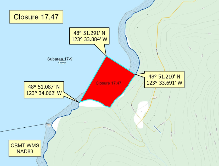
| 17.47 Bader's Beach, Saltspring Island | 17.47.png | The waters and intertidal foreshore of that portion of Subarea 17-9 inside a line that commences at 48°51.291'N, 123°33.884'W [in water], then southeasterly to 48°51.210'N,123°33.691'W [Bader's Beach, Saltspring Island], then following the shoreline southwesterly to 48°51.087'N,123°34.062'W [Bader's Beach, Saltspring Island], then northeasterly to the point of commencement. [NAD83] |
| 17.5 Departure Bay | 17.5.png | The waters and intertidal foreshore of Departure Bay from Pimbury Point to Horswell Bluff at 49°12.76' north latitude and 123°56.36' west longitude. [NAD83] |
| 17.6 Degnen Bay, Gabriola Island | 17.6.png | The waters and intertidal foreshore of Degnen Bay, Gabriola Island, lying north of a line drawn from a point on land at 49°08.028' north latitude and 123°43.129' west longitude thence northeasterly to a point of land at 49°08.115' north latitude and 123°42.767' west longitude. [NAD83] |
| 17.7 Silva Bay, Gabriola Island | 17.7.png | The waters and intertidal foreshore of Silva Bay, Gabriola Island lying within a line drawn from the southern tip of Law Point to the northwestern tip of Sear Island and thence southwesterly to the shoreline of Gabriola Island. [NAD83] |
| 17.8 Montague Harbour, Galiano Island | 17.8.png | The waters and intertidal foreshore of Montague Harbour, Galiano Island, inside a line drawn from Winstanley Point, thence northerly to the base of the overhead cable tower on the northeastern foreshore of the harbour. [NAD83] |
| 17.B Pirates Cove, De Courcy Island | 17.B.png | The waters and intertidal foreshore of that portion of Subarea 17-17 inside a line that commences at 49°05.640'N, 123°43.772'W [Pirates Cove, De Courcy Island], then northeasterly to 49°05.943'N, 123°43.788'W [Pirates Cove, De Courcy Island], then following the shoreline southeasterly to the point of commencement. [NAD83] |
| 17.D Princess Cove, Wallace Island | 17.D.png | The waters and intertidal foreshore of that portion of Subarea 17-2 inside a line that commences at 48°56.606'N, 123°33.547'W [Princess Cove], then northeasterly to 48°56.676'N, 123°33.409'W [Princess Cove, Wallace Island], then following the shoreline southeasterly to 48°56.585'N, 123°33.444'W [Princess Cove, Wallace Island], then northwesterly to 48°56.666'N, 123°33.433'W [unnamed islet], then following the shoreline northeasterly to 48°56.619'N, 123°33.506'W [unnamed islet], then northwesterly to 48°56.631'N, 123°33.521'W [Princess Cove], then northerly to 48°56.640'N, 123°33.524'W [Princess Cove], then northeasterly to the point of commencement. [NAD83] |
| 17.E Montague Harbour, Galiano Island | 17.E.png | The waters and intertidal foreshore of that portion of Subarea 17-2 inside a line that commences at 48°53.623'N, 123°24.206'W [Gray Peninsula, Galiano Island], then following the shoreline northwesterly to 48°57.784'N, 123°23.855'W [Montague Harbour, Galiano Island], then southwesterly to the point of commencement. [NAD83] |
| 17.F Clam Bay | 17.F.png | The waters and intertidal foreshore of that portion of Subarea 17-8 inside a line that commences at 48°59.474'N, 123°38.896'W [Leech Island], then southeasterly to 48°58.959'N, 123°38.145'W [Penelakut Spit, Penelakut Island], then following the shoreline southwesterly to 48°59.002'N, 123°39.327'W [Penelakut Island], then northeasterly to the point of commencement. [NAD83] |
| 17-6.A | 17-6.A.png | That portion of Subarea 17-6 west of a line drawn from a point starting at the boundary line for Subarea 17-8 on Penelakut (Kuper) Island at 48º56.06' N latitude and 123º37.88' W longitude heading in a straight line southwesterly to a point at 48º55.02' N latitude, 123º38.48' W longitude on the Subarea boundary line between Subareas 17-6 and 17-9. [NAD83] |
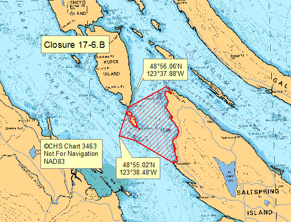
| 17-6.B | 17-6.B.png | That portion of Subarea 17-6 east of a line drawn from a point starting at the boundary line for Subarea 17-8 on Penelakut (Kuper) Island at 48º56.06' N latitude and 123º37.88' W longitude, heading in a straight line southwesterly to a point 48º55.03' N latitude, 123º38.48' W longitude on the Subarea boundary line between Subareas 17-6 and 17-9. [NAD83] |
Last updated: 2026-06-09
Related links
- Area maps
- Realtime bivalve shellfish safety harvesting map
- Information about recreational shellfish harvesting in BC
- Shellfish harvesting safety information
- Planned bivalve shellfish harvesting closures
- Identify your catch
Contact us
Email: DFO.PACCSSP-PCAMPAC.MPO@dfo-mpo.gc.ca
- Date modified: