
BC tidal area 19 - Victoria and Sidney: Bivalve shellfish contamination information
Eating contaminated shellfish can make you very sick and can even be life threatening.
Harvesting opportunities and closures change often throughout the year for conservation or public health reasons. Check the table below or our real-time bivalve shellfish safety harvesting map to ensure that it's legal and safe to harvest, every time you head out to fish. If you are a recreational harvester, you also need to review recreational shellfish harvesting opportunities and limits and ensure you are carrying a current tidal waters sport fishing licence.
Because of the risk of sanitary contamination, all bivalve shellfish harvesting is permanently closed within the following boundaries, often marked with signage or red concrete markers:
- 300 metres around industrial, municipal and sewage treatment plant outfall discharges
- 125 metres around a marina, ferry wharf, floating living accommodation, or any finfish net pen
If you are in an aquaculture facility there are some exceptions to the second item.
- 25 metres around any floating living accommodation facility located within a shellfish aquaculture facility where a zero-discharge and appropriate waste management plan is a condition of the Aquaculture Licence and is approved by the Regional Interdepartmental Committee
- 0 metres of any finfish net pen within an aquaculture facility where an Integrated Multi-Trophic Aquaculture Management Plan approved by the Regional Interdepartmental Committee is in operation.
Shellfish aquaculture facilities use markers at the corners of their licensed area.
Bivalve shellfish contamination status
Look at the first column below to see which species are safe to harvest. If there is information in the second column, it is both illegal and unsafe to harvest any bivalve species in those areas.
| Subarea | Marine biotoxin update (open bivalve species) | Sanitary contamination closures (closed to shellfish harvesting) |
|---|---|---|
| 19-1 | Closed to All Bivalve Species | |
| 19-2 | Closed to All Bivalve Species | |
| 19-3 | Closed to All Bivalve Species | |
| 19-4 | Clam - Butter;Clam - Littleneck;Clam - Manila;Mussels - all species combined;Oyster - Pacific | |
| 19-5 | Clam - Butter | |
| 19-6 | Closed to All Bivalve Species | |
| 19-7 | Closed to All Bivalve Species | |
| 19-8 | Closed to All Bivalve Species | |
| 19-9 | Closed to All Bivalve Species | |
| 19-10 | Closed to All Bivalve Species | |
| 19-11 | Closed to All Bivalve Species | |
| 19-12 | Closed to All Bivalve Species |
Last updated: 2026-07-23
Area descriptions
| Closure | Map | Area description |
|---|---|---|
| 19.1 Albert Head to Cordova Bay | 19.1.png | The waters and intertidal foreshore of Vancouver Island, lying inside a line drawn from Albert Head at 48°23.25' north latitude and 123°28.60' west longitude, thence southeasterly to a point in water at 48°22.22' north latitude and 123°21.30' west longitude, thence northeasterly to Staines Point on the Trial Islands at 48°23.67' north latitude and 123°18.27' west longitude, thence northeasterly to Gonzales Point at 48°24.69' north latitude and 123°17.61' west longitude, thence northerly along the intertidal foreshore of Saanich Peninsula to a point on land parallel to the end of Parker Road at 48°32.20' north latitude and 123°21.82' west longitude in Cordova Bay. [NAD83] |
| 19.10 Deep Cove to Patricia Bay | 19.10.png | The waters and intertidal foreshore of northeastern Saanich Inlet, lying inside a line drawn from Moses Point at 48°41.35' north latitude and 123°29.11' west longitude to Coal Point at 48°40.63' north latitude and 123°29.34' west longitude, thence southeasterly to a point on land at 48°38.90' north latitude and 123°27.64' west longitude. [NAD83] |
| 19.11 Squally Reach, Saanich Inlet | 19.11.png | The waters and intertidal foreshore of the west side of Squally Reach from a point on land at 48°32.45' N and 123°33.44 W which is located 200 m south of the southernmost creek (Irving Creek), thence following the shoreline northwards along the 10 m depth line, to a point on land at 48°33.08'N and 123°33.37'W, which is 200 m north of the northernmost creek. [NAD83] |
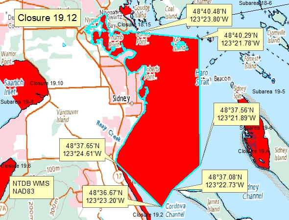
| 19.12 Bazan Bay | 19.12.png | The waters of Bazan Bay, Little Group Islands, and Tsehum Harbour inside a line drawn from a point on land at 48°37.65' N 123°24.61' W thence southeasterly to a point in water at 48°36.67' N 123°23.20' W thence northeasterly to a point in water at 48°37.08' N 123°22.73' W thence northeasterly to a point in water at 48°37.56' N 123°21.89' W thence northerly to a point on Dock Island at 48°40.29' N 123°21.78' W thence northwesterly to Curteis Point at 48°40.48' N 123°23.80' W thence to the point of commencement. [NAD83] |
| 19.13 North Yarrow Point | 19.13.png | The waters and intertidal foreshore of a small bay just north of Coles Bay lying inside a line drawn from a northerly point at 48°38.19' north latitude and 123°28.68' west longitude thence southerly to the opposite shore at 48°37.97' north latitude and 123°28.71' west longitude. [NAD83] |
| 19.14 Saanichton Bay | 19.14.png | The waters of Saanichton Bay south of a line drawn from a point on land on the Saanich Peninsula at 48°36.26' north latitude and 123°23.67' west longitude, thence southeasterly to a point in the water at 48°35.91' north latitude and 123°22.29' west longitude, thence due south to the tip of Cordova Spit. [NAD83] |
| 19.2 Saanich Peninsula, Curteis Point, Cordova Bay | 19.2.png | The intertidal foreshore of Saanich Peninsula, from Curteis Point southward to a point on shore, at 48°32.20' north latitude and 123°21.82' west longitude, parallel with the northern end of Parker Road, Cordova Bay. [NAD 27]. |
| 19.3 West Saanich Inlet | 19.3.png | The waters and intertidal foreshore of Saanich Inlet, including Mill Bay, extending from Hatch Point at 48°41.63' north latitude and 123°32.09' west longitude, thence following the low water mark to a point in water on the low water mark at 48°40.17' north latitude and 123°31.81' west longitude, thence southerly to the northern side of Verdier Point at 48°37.92' north latitude and 123°31.76' west longitude. [NAD 83] |
| 19.4 Thomson Cove, Saanich Inlet | 19.4.png | The waters and intertidal foreshore of Thomson Cove, Saanich Inlet, lying inside a line drawn from the northern headland of Thomson Cove to Henderson Point. [NAD83] |
| 19.5 Brentwood Bay, Saanich Inlet | 19.5.png | The waters and intertidal foreshore of Brentwood Bay, Saanich Inlet, lying inside a line drawn from Henderson Point at 48°35.89' north latitude and 123°28.79' west longitude to Willis Point at 48°34.65' north latitude and 123°29.13' west longitude. [NAD 27]. |
| 19.6 Coles Bay, Saanich Inlet | 19.6.png | The waters and intertidal foreshore of Coles Bay, Saanich Inlet, lying inside a line drawn from Yarrow Point to a point on the eastern shore of the bay 125 m south of the unnamed creek entering at 8600 Kleewyck Road. [NAD83] |
| 19.7 Finlayson Arm, Saanich Inlet | 19.7.png | The waters and intertidal foreshore of Finlayson Arm, Saanich Inlet, lying south of the power cables crossing the southern tip of Sawluctus Island. [NAD83] |
| 19.8 Quarantine Cove | 19.8.png | The waters and intertidal foreshore of Quarantine Cove lying inside a line drawn from William Head to the southern end of Weir Beach. [NAD83] |
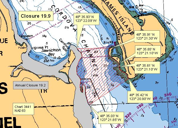
| 19.9 Cordova Spit to James Island to View Beach | 19.9.png | The subtidal waters in Cordova Channel inside a line commencing at the east boundary of closure 19.2 near the end of Cordova Spit off Saanich Peninsula at 48°35.93' north latitude and 123°22.09' west longitude, thence easterly to the northern tip of the small islet on the southwest side of James Island at 48°35.91' north latitude and 123°21.30' west longitude, thence following the shoreline southeasterly to southern tip of the islet at 48°35.65' north latitude and 123°21.10' west longitude, thence southerly to the northern tip of a spit at the southwest side of James Island at 48°35.61' north latitude and 123°21.10' west longitude, thence following the shoreline southeasterly to the southwest tip of James Island at 48°35.42' north latitude and 123°20.90' west longitude, thence southwesterly to a point at the eastern boundary of closure 19.2 at 48°35.03' north latitude and 123°21.85' west longitude. [NAD83] |
| 19.A Sidney Spit Marine Park | 19.A.png | The waters and intertidal foreshore of that portion of Subarea 19-6 inside the line that commences at 48°39.139'N, 123°20.650′W [Sidney Spit, Sidney Island], then following the shoreline southerly to 48°38.283′N, 123°20.389'W [Sidney Island], then northerly to the point on commencement. [NAD83] |
| 19.ii Mill Bay Area | 19.ii.png | In a portion of subarea 19-8, within the waters of Saanich Inlet inside a line that begins at 48°39.278' N 123°32.401' W then southeast to a point in water at 48°38.381' N 123°31.767' W then southwest to a point at 48°37.894' N 123°31.777' W then north following the shoreline to the beginning point. [NAD83] |
Last updated: 2026-07-23
Related links
- Area maps
- Realtime bivalve shellfish safety harvesting map
- Information about recreational shellfish harvesting in BC
- Shellfish harvesting safety information
- Planned bivalve shellfish harvesting closures
- Identify your catch
Contact us
Email: DFO.PACCSSP-PCAMPAC.MPO@dfo-mpo.gc.ca
- Date modified: