
BC tidal area 20 - Port Renfrew and Sooke: Bivalve shellfish contamination information
Eating contaminated shellfish can make you very sick and can even be life threatening.
Harvesting opportunities and closures change often throughout the year for conservation or public health reasons. Check the table below or our real-time bivalve shellfish safety harvesting map to ensure that it's legal and safe to harvest, every time you head out to fish. If you are a recreational harvester, you also need to review recreational shellfish harvesting opportunities and limits and ensure you are carrying a current tidal waters sport fishing licence.
Because of the risk of sanitary contamination, all bivalve shellfish harvesting is permanently closed within the following boundaries, often marked with signage or red concrete markers:
- 300 metres around industrial, municipal and sewage treatment plant outfall discharges
- 125 metres around a marina, ferry wharf, floating living accommodation, or any finfish net pen
If you are in an aquaculture facility there are some exceptions to the second item.
- 25 metres around any floating living accommodation facility located within a shellfish aquaculture facility where a zero-discharge and appropriate waste management plan is a condition of the Aquaculture Licence and is approved by the Regional Interdepartmental Committee
- 0 metres of any finfish net pen within an aquaculture facility where an Integrated Multi-Trophic Aquaculture Management Plan approved by the Regional Interdepartmental Committee is in operation.
Shellfish aquaculture facilities use markers at the corners of their licensed area.
Bivalve shellfish contamination status
Look at the first column below to see which species are safe to harvest. If there is information in the second column, it is both illegal and unsafe to harvest any bivalve species in those areas.
| Subarea | Marine biotoxin update (open bivalve species) | Sanitary contamination closures (closed to shellfish harvesting) |
|---|---|---|
| 20-1 | Mussels - all species combined | |
| 20-2 | Mussels - all species combined | |
| 20-3 | Mussels - all species combined | |
| 20-4 | Closed to All Bivalve Species | |
| 20-5 | Clam - Littleneck;Clam - Manila;Mussels - all species combined;Oyster - Pacific | |
| 20-6 | Clam - Littleneck;Clam - Manila;Mussels - all species combined;Oyster - Pacific | |
| 20-7 | Clam - Littleneck;Clam - Manila;Mussels - all species combined;Oyster - Pacific |
Last updated: 2026-06-09
Area descriptions
| Closure | Map | Area description |
|---|---|---|
| 20.1 Sooke Harbour and Sooke Basin | 20.1.png | The waters and intertidal foreshore of Sooke Harbour and Sooke Basin, lying inside a line drawn from the eastern tip of Whiffin Spit at 48°21.503' north latitude and 123°42.663' west longitude, thence due east to a point on the opposite shore at 48°21.467' north latitude and 123°42.480' west longitude, thence along the shoreline to Company Point at 48°20.839' north latitude and 123°43.084' west longitude, but excluding Conditionally Approved area 20.10A in Sooke Basin. [NAD83] |
| 20.2 Pedder Bay | 20.2.png | The waters and intertidal foreshore of Pedder Bay lying inside a line drawn from Cape Calver to William Head. [NAD83] |
| 20.4 Port Renfrew | 20.4.png | The waters and intertidal foreshore of Port San Juan, inside a line commencing at a point on land near Adze Head at 48°33.240' north latitude and 124°25.561' west longitude, extending northerly to a point in water at 48°33.719' north latitude and 124°25.609' west longitude, thence westerly to a point on land at 48°33.847' north latitude and 124°24.089' west longitude, thence following the shoreline southwesterly to a point on land near the San Juan River at 48°33.642' north latitude and 124°23.952' west longitude, thence southeasterly to a point on land at 48°33.569' north latitude and 124°23.908' west longitude, thence following the shoreline westerly to the point of commencement. [NAD 83] |
| 20.5 Becher Bay Marina, Becher Bay | 20.5.png | The waters and intertidal foreshore surrounding the Becher Bay Marina, lying inside a line drawn in a 195 m radius from any point on the perimeter of the dock fingers, commencing from a point on land in the south at 48°19.66' north latitude and 123°38.07' west longitude, and ending at a point on land in the north at 48°19.90' north latitude and 123°37.96' west longitude. [NAD83] |
| 20.6 Cheanuh Marina, Becher Bay | 20.6.png | The waters and intertidal foreshore surrounding the Cheanuh Marina in Becher Bay, lying inside a line drawn in a 265 m radius from any point on the perimeter of the dock fingers, commencing from a point on land in the south at 48°20.09' north latitude and 123°36.38' west longitude, and ending at a point on land in the north at 48°20.26' north latitude and 123°35.92' west longitude. [NAD83] |
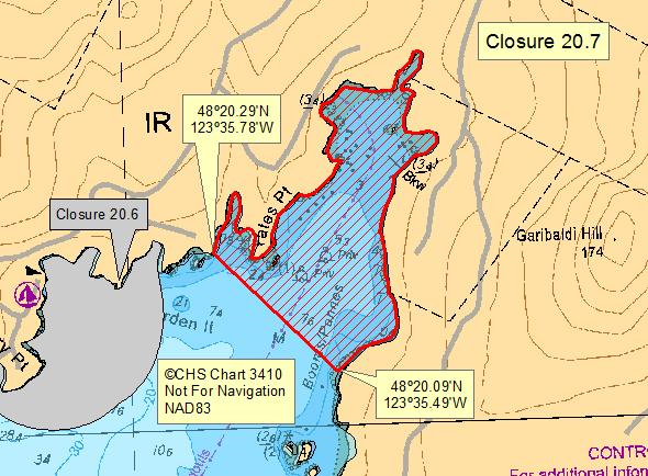
| 20.7 Eastern Head of Becher Bay | 20.7.png | The waters and intertidal foreshore of the easternmost head of Becher Bay, lying inside a line drawn from a point of land at 48°20.29' north latitude and 123°35.78' west longitude, thence southeasterly to a point on land on the opposite shore at 48°20.09' north latitude and 123°35.49' west longitude. [NAD83] |
| 20.8 Becher Bay | 20.8.png | The waters and intertidal foreshore in Becher Bay, inside a line drawn from a point on land on the southern shore of Frazer Island at 48°19.61' north latitude and 123°36.45' west longitude, thence following the shoreline to a point on land on the eastern shore of Frazer Island at 48°19.68' north latitude and 123°36.27' west longitude, thence southeasterly to the northeasternmost point of Village Island at 48°19.56' north latitude and 123°35.97' west longitude, thence southwesterly to the southernmost point of Village Island at 48°19.47' north latitude and 123°36.01' west longitude, thence southwesterly to a point in the water at 48°19.11' north latitude and 123°36.31' west longitude, thence northwesterly to a point in the water at 48°19.33' north latitude and 123°36.72' west longitude, thence northeasterly to the point of commencement. [NAD83] |
| 20.9 Sooke Bay | 20.9.png | The waters of Sooke Bay within a radius of 300 m of the wastewater outfall terminus at 48º21.19' north latitude and 123º46.16' west longitude. [NAD 83] |
Last updated: 2026-06-09
Related links
- Area maps
- Realtime bivalve shellfish safety harvesting map
- Information about recreational shellfish harvesting in BC
- Shellfish harvesting safety information
- Planned bivalve shellfish harvesting closures
- Identify your catch
Contact us
Email: DFO.PACCSSP-PCAMPAC.MPO@dfo-mpo.gc.ca
- Date modified: