
BC tidal areas 23 and 123 - Port Alberni and Bamfield: Bivalve shellfish contamination information
Eating contaminated shellfish can make you very sick and can even be life threatening.
Harvesting opportunities and closures change often throughout the year for conservation or public health reasons. Check the table below or our real-time bivalve shellfish safety harvesting map to ensure that it's legal and safe to harvest, every time you head out to fish. If you are a recreational harvester, you also need to review recreational shellfish harvesting opportunities and limits and ensure you are carrying a current tidal waters sport fishing licence.
Because of the risk of sanitary contamination, all bivalve shellfish harvesting is permanently closed within the following boundaries, often marked with signage or red concrete markers:
- 300 metres around industrial, municipal and sewage treatment plant outfall discharges
- 125 metres around a marina, ferry wharf, floating living accommodation, or any finfish net pen
If you are in an aquaculture facility there are some exceptions to the second item.
- 25 metres around any floating living accommodation facility located within a shellfish aquaculture facility where a zero-discharge and appropriate waste management plan is a condition of the Aquaculture Licence and is approved by the Regional Interdepartmental Committee
- 0 metres of any finfish net pen within an aquaculture facility where an Integrated Multi-Trophic Aquaculture Management Plan approved by the Regional Interdepartmental Committee is in operation.
Shellfish aquaculture facilities use markers at the corners of their licensed area.
Bivalve shellfish contamination status
Look at the first column below to see which species are safe to harvest. If there is information in the second column, it is both illegal and unsafe to harvest any bivalve species in those areas.
| Subarea | Marine biotoxin update (open bivalve species) | Sanitary contamination closures (closed to shellfish harvesting) |
|---|---|---|
| 23-1 | Closed to All Bivalve Species | |
| 23-2 | Closed to All Bivalve Species | |
| 23-3 | Clam, Littleneck;Clam, Manila;Mussels, All;Oyster, Pacific | |
| 23-4 | Clam, Butter;Clam, Littleneck;Clam, Manila;Mussels, All;Oyster, Pacific | |
| 23-5 | Clam, Littleneck;Clam, Manila;Mussels, All;Oyster, Pacific | |
| 23-6 | ||
| 23-7 | Clam, Littleneck;Clam, Manila;Mussels, All;Oyster, Pacific | |
| 23-8 | Clam, Horse;Geoduck | |
| 23-9 | Clam, Horse;Clam, Littleneck;Clam, Manila;Geoduck;Mussels, All;Oyster, Pacific | |
| 23-10 | Clam, Horse;Clam, Littleneck;Clam, Manila;Geoduck;Mussels, All;Oyster, Pacific | |
| 23-11 | Closed to All Bivalve Species | |
| 123-1 | Closed to All Bivalve Species | |
| 123-2 | Closed to All Bivalve Species | |
| 123-3 | Closed to All Bivalve Species | |
| 123-4 | Closed to All Bivalve Species | |
| 123-5 | Closed to All Bivalve Species | |
| 123-6 | Closed to All Bivalve Species | |
| 123-7 | Closed to All Bivalve Species | |
| 123-8 | Closed to All Bivalve Species | |
| 123-9 | Closed to All Bivalve Species |
Last updated: 2025-05-02 11:55:17
Area descriptions
| Closure | Map | Area description |
|---|---|---|
| 23.1 Bamfield Inlet and Grappler Inlet | 23.1.jpeg | The waters and intertidal foreshore of Bamfield Inlet and Grappler Inlet lying inside a line drawn from Aguilar Point light to the harbour limit on the opposite shore. [NAD83] |
| 23.10 Julia Passage | 23.10.jpeg | The waters and intertidal foreshore of Julia Passage, Barkley Sound. The southern passage entrance closure boundary consists of a line drawn between a point on the Vancouver Island shore located at latitude 48°57.10' north latitude and longitude 125°13.20' west longitude, and the closest headland on the southern island of the Alma Russell Islands. The closure extends north easterly to a line drawn from the north eastern tip of the northern most Alma Russell Island to the Vancouver Island shore [NAD 27]. |
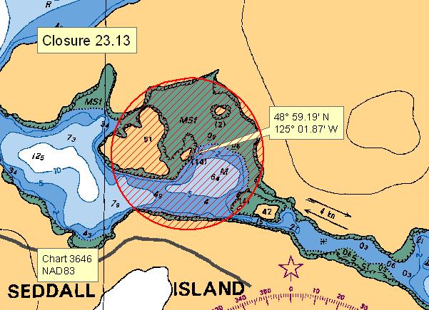
| 23.13 Area between Fatty Basin and Useless Inlet | 23.13.jpeg | The waters and intertidal foreshore in the large bay between Useless Inlet and Fatty Basin that lie within a 150 meter radius from a point on the unnamed rock at 48°59.19 minutes north latitude and 125°01.87 minutes west longitude. [NAD83] |
| 23.16 Poett Nook | 23.16.jpeg | The waters and intertidal foreshore of Poett Nook lying inside a line across the narrows at the entrance, from a point on land on the west side of the entrance at 48°53.00' north latitude and 125°02.99' west longitude, to a point on land on the east side of the entrance at 48°53.00' north latitude and 125°02.89' west longitude. [NAD83] |
| 23.17 Santa Maria Island | 23.17.jpeg | The waters and intertidal foreshore of northeastern Santa Maria Island, in Numukamis Bay, south of a line drawn from the northeastern most tip of Santa Maria Island at 48°53.71' north latitude and 125°01.23' west longitude thence easterly to a point of land at 48°53.72' north latitude and 125°01.13' west longitude, and north of a line drawn from a point on land on eastern Santa Maria Island at 48°53.65' north latitude and 125°01.26' west longitude thence due east to a point on land at 48° 53.65' north latitude and 125°01.15' west longitude. [NAD83] |
| 23.18 Effingham Inlet | 23.18.jpeg | The waters and intertidal foreshore on the southwest side of Effingham Inlet, west of Webster Island, within a 125 meter radius of the dock at 49°00.11' north latitude and 125°11.61' west longitude. [NAD83] |
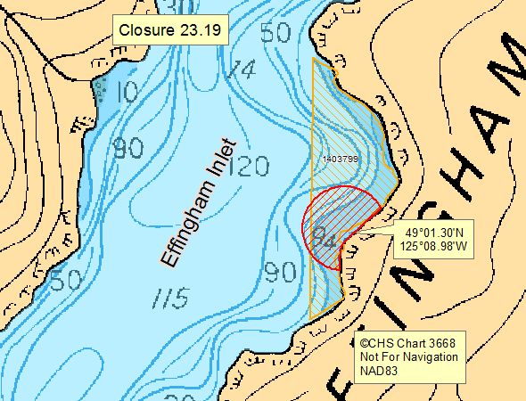
| 23.19 East Effingham Inlet, land file #1403799 | 23.19.jpeg | The waters and intertidal foreshore of the east side of Effingham Inlet, within a distance of 125 meters from the outer perimeter of the floating living accommodation located at or near 49°01.30' north latitude and 125°08.98' west longitude, within aquaculture tenure land file #1403799. [NAD 83] |
| 23.2 Ucluelet Inlet | 23.2.jpeg | The waters and intertidal foreshore of Ucluelet Inlet and a portion of Newcombe Channel, Barkley Sound inside a line drawn from a point of land on the southeast side of the Ucluth Peninsula by Spring Cove at 48°55.57' north latitude and 125°31.56' west longitude thence southeasterly to the northernmost point of Francis Island at 48°55.46' north latitude and 125°31.43' west longitude thence following the shoreline southwesterly to the southernmost point of Francis Island at 48°55.29' north latitude and 125°31.45' west longitude thence southerly to the easternmost point of Jenny Reef at 48°55.00' north latitude and 125°31.50' west longitude thence southeasterly to an islet in the George Fraser Islands at 48°54.79' north latitude and 125°30.97' west longitude thence northeasterly to a point of land at 48°55.31' north latitude and 125°30.48' west longitude thence following the shoreline and returning to the point of commencement. [NAD83] |
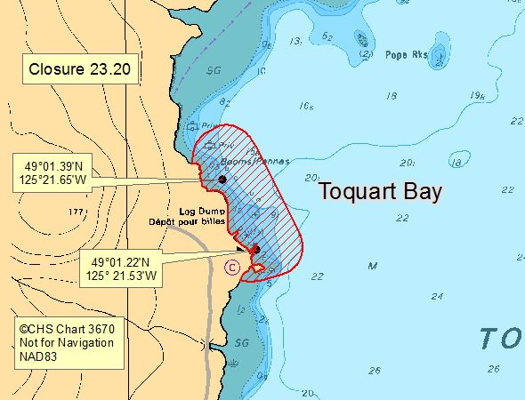
| 23.20 Toquart Bay - Coulson forest Products Dock and Toquart Bay Campsite Dock | 23.20.jpeg | The waters and intertidal foreshore at the head of Toquart Bay, in a 125 m radius from any point on the dock fingers of the Coulson Forest Products dock located at 49°01.39' north latitude and 125°21.65' west longitude, and in a 125 m radius from any point on the dock fingers of the Toquart Bay campsite dock at 49°01.22' north latitude and 125°21.53' west longitude. [NAD83] |
| 23.22 San Mateo Bay, land file #1405569 | 23.22.jpeg | The waters and intertidal foreshore of San Mateo Bay, within a distance of 125 meters from the outer perimeter of the floating living accommodation located at or near 48°56.40' north latitude and 124°59.10' west longitude, within aquaculture tenure land file #1405569. [NAD 83] |
| 23.23 West Effingham Inlet, land file #1409678 | 23.23.jpeg | The waters and intertidal foreshore of the west side of Effingham Inlet, within a distance of 125 meters from the outer perimeter of the floating living accommodation located at or near 49°00.79' north latitude and 125°10.84' west longitude, within aquaculture tenure land file #1409678. [NAD 83] |
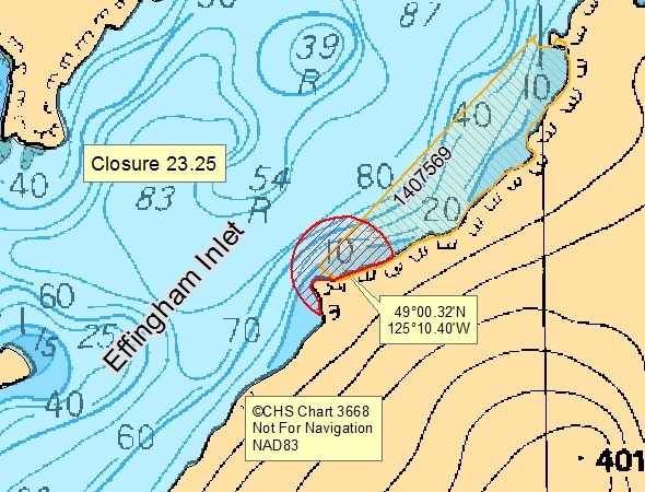
| 23.25 East Effingham Inlet, land file #1407569 | 23.25.jpeg | The waters and intertidal foreshore of the east side of Effingham Inlet, within a distance of 125 meters from the outer perimeter of the floating living accommodation located at or near 49°00.32' north latitude and 125°10.40' west longitude, within aquaculture tenure land file #1407569. [NAD 83] |
| 23.26 Somass River Estuary | 23.26.jpeg | The waters and intertidal foreshore of the Somass River Estuary in Port Alberni, inside a line extending from a point on the northwestern corner of the pond at 49°15.19' north latitude and 124°49.36' west longitude easterly across the Somass River Estuary to a point on land at 49°15.12' north latitude and 124°48.70' west longitude, thence southwesterly along the intertidal foreshore to a point on the breakwater which extends from Lupsi Cupsi Point at 49°14.55' north latitude and 124° 49.13' west longitude, thence northwesterly across the Somass River Estuary to a point on land at 49°14.70' north latitude and 124°49.53' west longitude, thence northeasterly along the margins of the sewage disposal basin and pond to the point of commencement. [NAD83] |
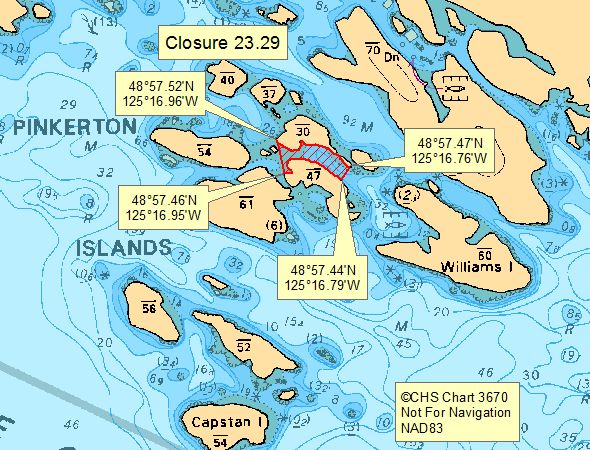
| 23.29 Pinkerton Islands | 23.29.jpeg | The waters and intertidal foreshore in the centre of the Pinkerton Islands, east of a line drawn from the westernmost point of the islet marked as 30 m high on CHS Chart 3670 at 48°57.52' north latitude and 125°16.96' west longitude southeasterly to the westernmost point of the islet marked as 47 m high at 48°57.46' north latitude and 125°16.96' west longitude; and west of a line drawn from the southeasternmost point of the small islet southeast of Islet marked 30 m high at 48°57.47' north latitude and 125°16.76' west longitude southwesterly to a point on land on Islet marked 47 m high at 48°57.44' north latitude and 125°16.79' west longitude. [NAD 83] |
| 23.3 Cigarette Cove, Entrance Inlet | 23.3.jpeg | The waters and intertidal foreshore of Cigarette Cove, Entrance Inlet, lying inside of a line drawn across the entrance to the cove at its narrowest point. [NAD83] |
| 23.31 Head of Uchucklesit Inlet | 23.31.jpeg | The waters and intertidal foreshore of the head of Uchucklesit Inlet located westerly of a line drawn from a point on land at 49°01.14' north latitude and 125°02.09' west longitude, thence southwesterly to a point on land at 49°00.67' north latitude and 125°02.50' west longitude. [NAD83] |
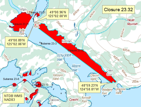
| 23.32 Eastern shore of Uchucklesit Inlet | 23.32.jpeg | The waters and intertidal foreshore on the eastern shore of Uchucklesit Inlet, inside a line drawn from a point of land on Caiger Point at 49°00.96' north latitude and 125°02.00' west longitude, thence 150 m seaward in a southwesterly direction to a point in water at 49°00.89' north latitude and 125°02.06' west longitude, thence southeasterly to a point on land in Green Cove at 48°59.23' north latitude and 124°58.81' west longitude. [NAD83] |
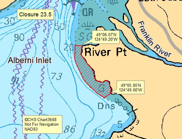
| 23.5 River Point, Alberni Inlet | 23.5.jpeg | The intertidal foreshore of Alberni Inlet from River Point to a point 480 m south. [NAD83] |
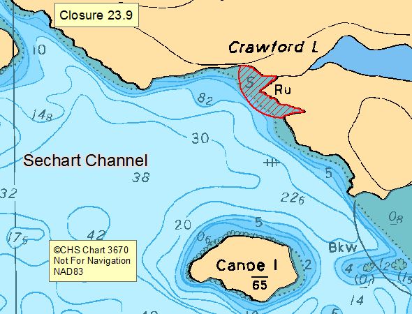
| 23.9 Crawford Creek, Sechart Channel | 23.9.jpeg | The waters and intertidal foreshore inside a 125 metre radius of the mouth of the creek draining Crawford Lake into Sechart Channel. [NAD83] |
| 23.ll Ritherdon Bay, Landfile #1401757, Oysters Only | 23.ll.jpeg | The waters and intertidal foreshore of that portion of Subarea 23-3 inside a line that commences at 48°57.180’N and 124°58.874’W [in water] then in a straight line to 48°57.173’N and 124°58.615’W [in water] then in a straight line to 48°55.139’N and 124°58.621’W [on land] then following the shoreline to 48°57.073’N and 124°58.872’W [on land] then in a straight line to the point of commencement; including BC Land Registry Aquaculture Tenure #1401757. [NAD 83] |
| 23-6.A | 23-6.A.jpeg | Subarea 23-6 except that portion northeast of a line drawn from a point of land at 48°58.47' north latitude and 125°04.92' west longitude to a point of land at 48°58.61' north latitude and 125°05.05' west longitude, known as Useless Inlet. |
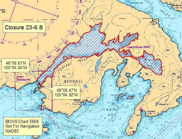
| 23-6.B | 23-6.B.jpeg | That portion of Subarea 23-6 northeast of a line drawn from a point of land at 48°58.47' north latitude and 125°04.92' west longitude to a point of land at 48°58.61' north latitude and 125°05.05' west longitude, known as Useless Inlet |
Last updated: 2025-05-02 11:55:17
Related links
- Area maps
- Realtime bivalve shellfish safety harvesting map
- Information about recreational shellfish harvesting in BC
- Shellfish harvesting safety information
- Planned bivalve shellfish harvesting closures
- Identify your catch
Contact us
Email: DFO.PACCSSP-PCAMPAC.MPO@dfo-mpo.gc.ca
- Date modified: