
BC tidal areas 24 and 124 - Tofino, Flores Island, Meares Island and Vargas Island: Bivalve shellfish contamination information
Eating contaminated shellfish can make you very sick and can even be life threatening.
Harvesting opportunities and closures change often throughout the year for conservation or public health reasons. Check the table below or our real-time bivalve shellfish safety harvesting map to ensure that it's legal and safe to harvest, every time you head out to fish. If you are a recreational harvester, you also need to review recreational shellfish harvesting opportunities and limits and ensure you are carrying a current tidal waters sport fishing licence.
Because of the risk of sanitary contamination, all bivalve shellfish harvesting is permanently closed within the following boundaries, often marked with signage or red concrete markers:
- 300 metres around industrial, municipal and sewage treatment plant outfall discharges
- 125 metres around a marina, ferry wharf, floating living accommodation, or any finfish net pen
If you are in an aquaculture facility there are some exceptions to the second item.
- 25 metres around any floating living accommodation facility located within a shellfish aquaculture facility where a zero-discharge and appropriate waste management plan is a condition of the Aquaculture Licence and is approved by the Regional Interdepartmental Committee
- 0 metres of any finfish net pen within an aquaculture facility where an Integrated Multi-Trophic Aquaculture Management Plan approved by the Regional Interdepartmental Committee is in operation.
Shellfish aquaculture facilities use markers at the corners of their licensed area.
Bivalve shellfish contamination status
Look at the first column below to see which species are safe to harvest. If there is information in the second column, it is both illegal and unsafe to harvest any bivalve species in those areas.
| Subarea | Marine biotoxin update (open bivalve species) | Sanitary contamination closures (closed to shellfish harvesting) |
|---|---|---|
| 24-1 | Closed to All Bivalve Species | |
| 24-2 | Closed to All Bivalve Species | |
| 24-3 | Closed to All Bivalve Species | |
| 24-4 | Closed to All Bivalve Species | |
| 24-5 | Closed to All Bivalve Species | |
| 24-6 | ||
| 24-7 | Geoduck;Clam - Horse | |
| 24-8 | Geoduck;Clam - Horse | |
| 24-9 | Geoduck;Clam - Horse;Clam - Littleneck;Clam - Manila;Mussels - all species combined;Oyster - Pacific | |
| 24-10 | Closed to All Bivalve Species | |
| 24-11 | Closed to All Bivalve Species | |
| 24-12 | Closed to All Bivalve Species | |
| 24-13 | Closed to All Bivalve Species | |
| 24-14 | Closed to All Bivalve Species | |
| 124-1 | Closed to All Bivalve Species | |
| 124-2 | Closed to All Bivalve Species | |
| 124-3 | Closed to All Bivalve Species | |
| 124-4 | Closed to All Bivalve Species |
Last updated: 2026-06-09
Area descriptions
| Closure | Map | Area description |
|---|---|---|
| 24.1 Van Nevel Channel and Duffin Passage | 24.1.png | The waters and intertidal foreshore of Templar Channel, Van Nevel Channel, Duffin Passage, and Browning Passage, inside a line drawn from the eastern shore of Esowista Peninsula at 49°07.64' north latitude and 125°53.02' west longitude, thence northeasterly to the green navigation buoy in Browning Passage at 49°08.37' north latitude and 125°52.07' west longitude, thence northeasterly to a point of land on Meares Island at 49°09.01' north latitude and 125°51.95' west longitude, thence northwesterly following the shoreline to a point on land on Meares Island at 49°09.22' north latitude and 125°52.50' west longitude, thence due west to the southernmost tip of Morpheus Island at 49°09.22' north latitude and 125°52.70' west longitude, thence northwesterly following the shoreline to a point on land at 49°09.47' north latitude and 125°52.91' west longitude, thence northwesterly to a point on land on Stockham Island at 49°10.14' north latitude and 125°53.72' west longitude, thence westerly following the shoreline of Stockham Island to its northernmost tip at 49°10.39' north latitude and 125°54.16' west longitude, thence northwesterly to a point of land on Meares Island, north of the Opitsat wharf at 49°10.48' north latitude and 125°54.26' west longitude, thence westerly following the shoreline of Meares Island to a point of land southeast of Schindler Point at 49°10.46' north latitude and 125°55.21' west longitude, thence southwesterly to the northeastern-most tip of Stubbs Island at 49°09.72' north latitude and 125°55.50' west longitude, thence southerly following the shoreline to an unnamed point on the southern tip of Stubbs Island at 49°09.21' north latitude and 125°55.94' west longitude, thence southerly to the easternmost tip of Wickaninnish Island at 49°08.53' north latitude and 125°56.00' west longitude, thence southerly following the shoreline to an unnamed point on the southeast tip of the island at 49°07.91' north latitude and 125°56.21' west longitude, thence southeasterly to the northeastern-most tip of Echachis Island at 49°07.82' north latitude and 125°56.15' west longitude, thence southerly following the shoreline to southwestern tip of the island at 49°07.47' north latitude and 125°56.43' west longitude, thence easterly to an unnamed point on the west side of the Esowista Peninsula at 49°07.51' north latitude and 125°54.39' west longitude, thence following the shoreline northeasterly to an unnamed point on the south side of MacKenzie Beach at 49°07.68' north latitude and 125°54.16' west longitude, thence northwesterly to an unnamed point on the north side of MacKenzie Beach at 49°08.00' north latitude and 125°54.58' west longitude, thence following the shoreline of the Esowista Peninsula to the point of commencement. [NAD83] |
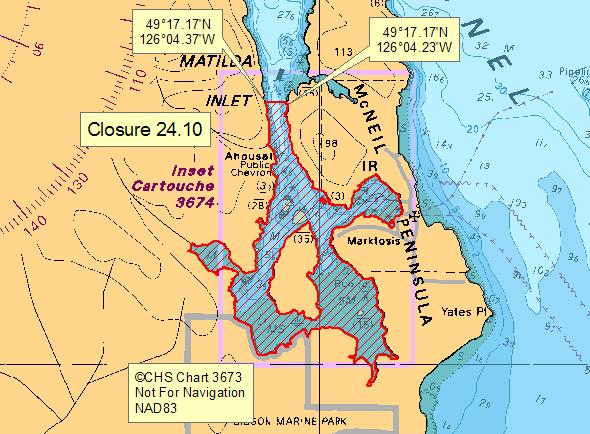
| 24.10 Matilda Inlet | 24.10.png | The waters and intertidal foreshore of Matilda Inlet, Flores Island, south of a line drawn from the point of land at 49°17.17' north latitude and 126°04.23' west longitude, thence due west to the opposite side of the inlet to a point on land at 49°17.17' north latitude and 126°04.37' west longitude. [NAD83] |
| 24.11 Sydney Inlet | 24.11.png | The waters and intertidal foreshore of Sydney Inlet within a radius of 800 m of the wastewater outfall terminus at 49°22.01' north latitude and 126°15.30' west longitude, extending northwesterly along the shore of Openit Peninsula to a point on land at 49°22.39' north latitude and 126°15.60' west longitude, and southeasterly along the shore of Openit Peninsula to a point on land at 49°21.58' north latitude and 126°15.22' west longitude. [NAD 83] |
| 24.14 Millar Channel | 24.14.png | The waters lying inside a radius of 300 m of a point in water located at 49°17.402' north latitude and 126°2.785' west longitude. [NAD83] |
| 24.4 Portion of Warn Bay | 24.4.png | The waters and intertidal foreshore of a portion of the small bay north of the Maltby Islets, in Warn Bay, from a point on Vancouver Island at 49°14.70' north latitude and 125°46.26' west longitude, thence southerly to a point on a small unnamed islet at 49°14.57' north latitude and 125°46.26' west longitude, thence following the shoreline of the islet easterly to a point at 49°14.57' north latitude and 125°46.19' west longitude, thence to a point on Vancouver Island at 49°14.62' north latitude and 125°46.15' west longitude, thence following the Vancouver Island shoreline northwesterly to the point of commencement. [NAD83] |
| 24.7 Hot Springs Cove Dock | 24.7.png | The waters and intertidal foreshore of Hot Springs Cove north of line drawn from a point on Openit Peninsula located at 49°21.66' north latitude and 126°15.94' west longitude true west to a point on the shoreline of Vancouver Island located at 49°21.66' north latitude and 126°16.18' west longitude. [NAD 83] |
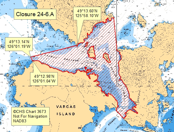
| 24-6.A | 24-6.A.png | That portion of Subarea 24-6 east of a line from an unnamed point on Vargas Island at 49°12.984' north latitude, 126°01.0433' west longitude drawn North to a point near Eby Rock at 49°13.143' north latitude, 126°01.189' west longitude then South of a line to the western most point on Morphee Island (at 49°13.6' north latitude, 125°58.1' west longitude), then east of a line from this point to a prominent unnamed point on Vancouver Island approximately 1/2 mile northwest of the western most point of Morfee Island (at 49°13.6' north latitude, 125°58.1' west longitude) |
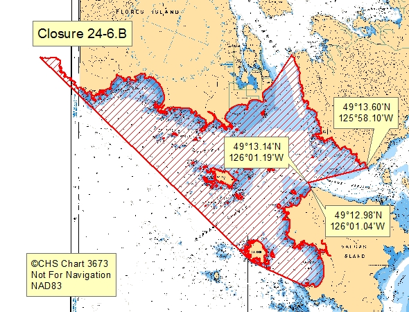
| 24-6.B | 24-6.B.png | Subarea 24-6 except that portion of Subarea 24-6 east of a line from an unnamed point on Vargas Island at 49°12.984' north latitude, 126°01.0433' west longitude drawn North to a point near Eby Rock at 49°13.143' north latitude, 126°01.189' west longitude then South of a line to the western most point on Morphee Island (at 49°13.6' north latitude, 125°58.1' west longitude), then east of a line from this point to a prominent unnamed point on Vancouver Island approximately 1/2 mile northwest of the western most point of Morfee Island (at 49°13.6' north latitude, 125°58.1' west longitude) |
| Calmus Passage to Bedwell Sound | Calmus.png | Pacific Fishery Management Subareas 24-6.A and 24-7. |
Last updated: 2026-06-09
Related links
- Area maps
- Realtime bivalve shellfish safety harvesting map
- Information about recreational shellfish harvesting in BC
- Shellfish harvesting safety information
- Planned bivalve shellfish harvesting closures
- Identify your catch
Contact us
Email: DFO.PACCSSP-PCAMPAC.MPO@dfo-mpo.gc.ca
- Date modified: