
BC tidal areas 25 and 125 - Nootka Sound, Esperanza Inlet: Bivalve shellfish contamination information
Eating contaminated shellfish can make you very sick and can even be life threatening.
Harvesting opportunities and closures change often throughout the year for conservation or public health reasons. Check the table below or our real-time bivalve shellfish safety harvesting map to ensure that it's legal and safe to harvest, every time you head out to fish. If you are a recreational harvester, you also need to review recreational shellfish harvesting opportunities and limits and ensure you are carrying a current tidal waters sport fishing licence.
Because of the risk of sanitary contamination, all bivalve shellfish harvesting is permanently closed within the following boundaries, often marked with signage or red concrete markers:
- 300 metres around industrial, municipal and sewage treatment plant outfall discharges
- 125 metres around a marina, ferry wharf, floating living accommodation, or any finfish net pen
If you are in an aquaculture facility there are some exceptions to the second item.
- 25 metres around any floating living accommodation facility located within a shellfish aquaculture facility where a zero-discharge and appropriate waste management plan is a condition of the Aquaculture Licence and is approved by the Regional Interdepartmental Committee
- 0 metres of any finfish net pen within an aquaculture facility where an Integrated Multi-Trophic Aquaculture Management Plan approved by the Regional Interdepartmental Committee is in operation.
Shellfish aquaculture facilities use markers at the corners of their licensed area.
Bivalve shellfish contamination status
Look at the first column below to see which species are safe to harvest. If there is information in the second column, it is both illegal and unsafe to harvest any bivalve species in those areas.
| Subarea | Marine biotoxin update (open bivalve species) | Sanitary contamination closures (closed to shellfish harvesting) |
|---|---|---|
| 25-1 | Closed to All Bivalve Species | |
| 25-2 | Closed to All Bivalve Species | |
| 25-3 | Closed to All Bivalve Species | |
| 25-4 | Clam - Littleneck;Clam - Manila;Mussels - all species combined;Oyster - Pacific | |
| 25-5 | Clam - Littleneck;Clam - Manila;Mussels - all species combined;Oyster - Pacific | |
| 25-6 | Clam - Littleneck;Clam - Manila;Mussels - all species combined;Oyster - Pacific | |
| 25-7 | Closed to All Bivalve Species | |
| 25-8 | Clam - Littleneck;Clam - Manila;Mussels - all species combined;Oyster - Pacific | |
| 25-9 | Closed to All Bivalve Species | |
| 25-10 | Closed to All Bivalve Species | |
| 25-11 | Clam - Littleneck;Clam - Manila;Mussels - all species combined;Oyster - Pacific | |
| 25-12 | Closed to All Bivalve Species | |
| 25-13 | Closed to All Bivalve Species | |
| 25-14 | Closed to All Bivalve Species | |
| 25-15 | Closed to All Bivalve Species | |
| 25-16 | Closed to All Bivalve Species | |
| 125-1 | Closed to All Bivalve Species | |
| 125-2 | Closed to All Bivalve Species | |
| 125-3 | Closed to All Bivalve Species | |
| 125-4 | Closed to All Bivalve Species | |
| 125-5 | Closed to All Bivalve Species | |
| 125-6 | Closed to All Bivalve Species |
Last updated: 2026-07-24
Area descriptions
| Closure | Map | Area description |
|---|---|---|
| 25.1 Friendly Cove, Nootka Island | 25.1.png | The waters and intertidal foreshore of Friendly Cove, lying inside a line drawn from the westernmost tip of the unnamed island north of San Rafael Island at 49°35.63' north latitude and 126°36.92' west longitude, and thence due north to a point on land on Nootka Island at 49°35.81' north latitude and 126°36.92' west longitude. [NAD83] |
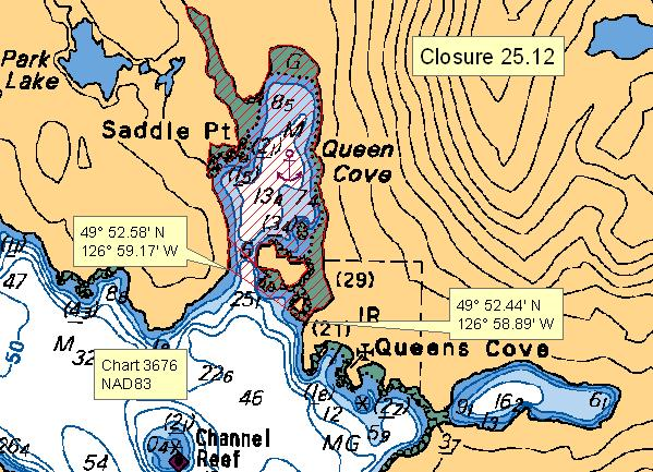
| 25.12 Queen Cove, Vancouver Island | 25.12.png | The waters and intertidal foreshore of that portion of Subarea 25-12 inside of a line that commences at 49°52.581'N, 126°59.168'W [Queens Cove, Vancouver Island], then following the shoreline easterly to 49°52.451'N, 126°58.892'W [Queens Cove, Vancouver Island], then northwesterly to the point of commencement. [NAD83] |
| 25.15 Ceepeecee, Esperanza Inlet | 25.15.png | The waters and intertidal foreshore of that portion of Subarea 25-9 inside of a line that commences at 49°52.385'N, 126°42.997'W [Ceepeecee, Esperanza Inlet], then following the shoreline southeasterly to 49°52.305'N, 126°42.670'W [Ceepeecee, Esperanza Inlet], then northwesterly to the point of commencement. [NAD83] |
| 25.16 Mouth of Cover Creek, Esperanza Inlet | 25.16.png | The waters and intertidal foreshore of that portion of Subarea 25-9 within a 300 metre radius of the mouth of Cover Creek at 49°52.298'N, 126°44.592'W [mouth of Cover Creek, Esperanza Inlet]. [NAD83] |
| 25.19 Unnamed Islets South of the Entrance of Allman Lagoon | 25.19.png | The waters and intertidal foreshore of that portion of Subarea 25-4 surrounding the unnamed group of islets south of the entrance to Allman Lagoon. The group of islets is 67 metres in height, and is centered at 49°42.100'N, 126°31.782'W. [NAD83] |
| 25.20 Valdes Bay, Vancouver Island | 25.20.png | The waters and intertidal foreshore of that portion of Subarea 25-4 inside of a line that commences at 49°43.908'N, 126°29.450'W [Valdes Bay, Vancouver Island], then following the shoreline easterly to 49°43.800'N, 126°29.313'W [Valdes Bay, Vancouver Island], then northwesterly to the point of commencement. [NAD83] |
| 25.21 Jewitt Cove, Strange Island | 25.21.png | The waters and intertidal foreshore of that portion of Subarea 25-8 inside of a line that commences at 49°41.521'N, 126°36.205'W [Jewitt Cove, Strange Island], then east to 49°41.521'N, 126°36.104'W [Jewitt Cove, Strange Island], then following the shoreline westerly to the point of commencement. [NAD83] |
| 25.22 Galiano Bay, Vancouver Island | 25.22.png | The waters and intertidal foreshore of that portion of Subarea 25-4 inside of a line that commences at 49°43.135'N, 126°27.997'W [Galiano Bay, Vancouver Island], then southwesterly to 49°42.753'N, 126°28.690'W [Galiano Bay, Vancouver Island], then northeasterly to the point of commencement. [NAD83] |
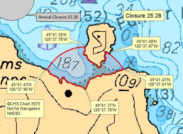
| 25.28 Plumper Harbour, Nootka Island | 25.28.png | The waters and intertidal foreshore of that portion of Subarea 25-6 within a 240 metre radius of the head of an unnamed cove at 49°41.372'N, 126°37.782'W [unnamed cove, Plumper Harbour]. The radius intersects with Funter Island. [NAD83] |
| 25.3 Kendrick Inlet, Nootka Island | 25.3.png | The waters and intertidal foreshore of that portion of Subarea 25-6 within a 300 metre radius of the logging camp dock at 49°43.402'N, 126°38.997'W [Kendrick Inlet, Nootka Island]. [NAD83] |
| 25.30 Northwest Side of Bligh Island | 25.30.png | The waters and intertidal foreshore of that portion of Subarea 25-6 inside a line that commences at 49°39.857'N, 126°31.896'W [Bligh Island], then following the shoreline southerly to 49°39.710'N, 126°31.958'W [Bligh Island], then northwesterly to 49°39.764'N, 126°32.035'W [unnamed islet], then following the shoreline northeasterly to 49°39.825'N, 126°31.981'W [unnamed islet], then northeasterly to the point of commencement. [NAD83] |
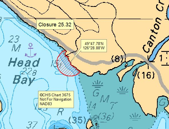
| 25.32 Head Bay, Tlupana Inlet | 25.32.png | The waters and intertidal foreshore of that portion of Subarea 25-5 within a 125 metre radius of the Canton Creek Lodge dock at 49°47.780'N, 126°28.882'W [Head Bay, Tlupana Inlet]. [NAD83] |
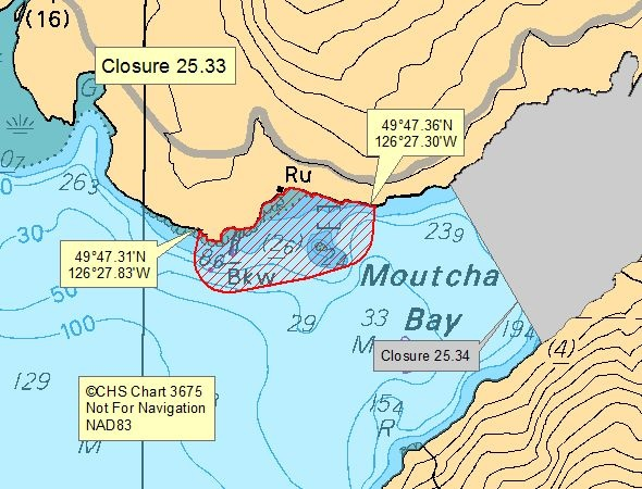
| 25.33 Moutcha Bay, Tlupana Inlet | 25.33.png | The waters and intertidal foreshore of that portion of Subarea 25-5 within a 125 metre radius of the Moutcha Bay Lodge site in Tlupana Inlet from any point on the perimeter of the infrastructure encompassing the dock, sewage outfall pipe, and fish holding pens at the Conuma hatchery docks. The closure commences at 49°47.348'N, 126°27.309'W [Moutcha Bay, Tlupana Inlet], ending at 49°47.294'N, 126°27.829'W [Moutcha Bay, Tlupana Inlet]. [NAD83] |
| 25.34 Mouth of Conuma River, Moutcha Bay, Tlupana Inlet | 25.34.png | The waters and intertidal foreshore of that portion of Subarea 25-5 inside of a line that commences at 49°47.395'N, 126°27.068'W [Moutcha Bay, Tlupana Inlet], then following the shoreline southeasterly to 49°47.089'N, 126°26.789'W [Moutcha Bay, Tlupana Inlet], then northwesterly to the point of commencement. [NAD83] |
| 25.35 Newton Cove, Espinosa Inlet | 25.35.png | The waters and intertidal foreshore of that portion of Subarea 25-11 within a 500 metre radius of the floating resort located at or near 49°52.456'N, 126°56.581'W [Newton Cove, Espinosa Inlet]. [NAD83] |
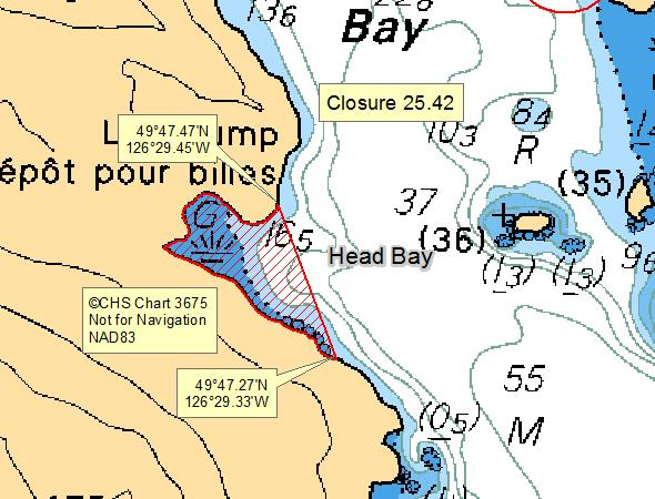
| 25.42 Unnamed Bay, west side of Head Bay | 25.42.png | The waters and intertidal foreshore of the small bay at the west side of Head Bay, from a point on land at 49°47.47' north latitude and 126°29.45' west longitude, thence southeasterly to a point on land at 49°47.27' north latitude and 126°29.33' west longitude.' [NAD 83] |
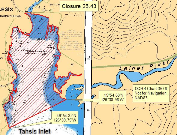
| 25.43 Head of Tahsis Inlet | 25.43.png | The waters and intertidal foreshore at the head of Tahsis Inlet, inside a line drawn from a point of land at 49°54.60' north latitude and 126°38.96' west longitude thence southwesterly to a point of land at 49°54.32' north latitude and 126°39.79' west longitude. [NAD 83] |
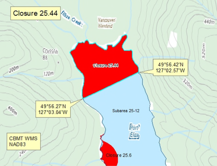
| 25.44 - Head of Port Eliza | 25.44.png | The waters and intertidal foreshore of the head of Port Eliza, northwest of a line drawn from a point of land at 49°56.27' north latitude and 127°03.04' west longitude easterly to a point on land at 49°56.42' north latitude and 127°02.57' west longitude. [NAD 83] |
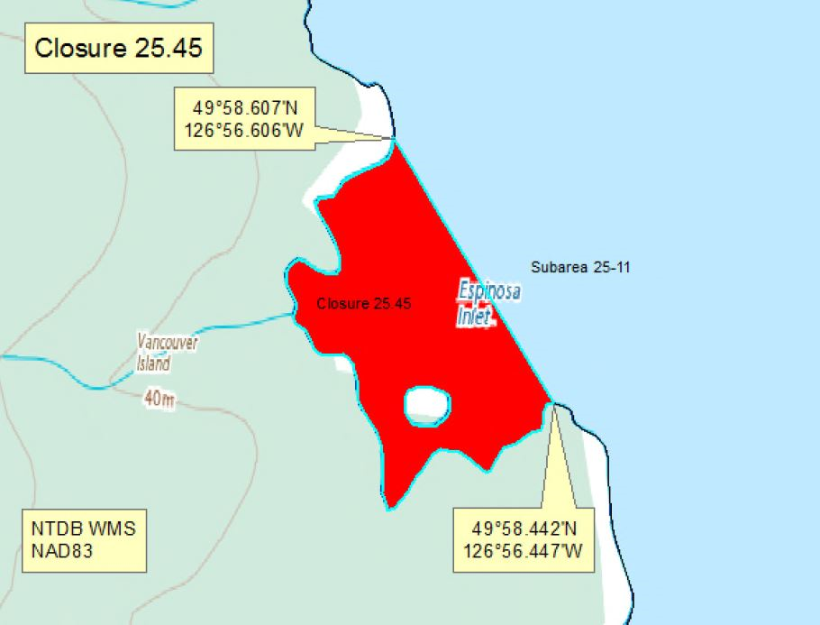
| 25.45 Espinosa Inlet, Esperanza Inlet | 25.45.png | The waters and intertidal foreshore of the bay in northwest Espinosa Inlet containing landfile 1411097, located easterly of a line drawn from a point on land at 49°58.607' north latitude and 126°56.606' west longitude, thence southwesterly to the opposite point on land at 49°58.442' north latitude and 126°56.447' west longitude. [NAD 83] |
| 25.7 Three Bay Cove, Vancouver Island | 25.7.png | The waters and intertidal foreshore of that portion of Subarea 25-4 inside of a line that commences at 49°41.514'N, 126°29.504'W [Three Bay Cove, Vancouver Island], then following the shoreline southeasterly to 49°41.499'N, 126°29.514'W [Three Bay Cove, Vancouver Island], then northwesterly to the point of commencement. [NAD83] |
| 25.A Santa Gertrudis Cove, Nootka Island | 25.A.png | The waters and intertidal foreshore of that portion of Subarea 25-6 inside the line that commences at 49°36.218'N, 126°36.218'W [Santa Gertrudis Cove, Nootka Island], then southerly to 49°36.082'N, 126°36.925'W [Santa Gertrudis Cove, Nootka Island], then following the shoreline westerly to the point of commencement. [NAD83] |
Last updated: 2026-07-24
Related links
- Area maps
- Realtime bivalve shellfish safety harvesting map
- Information about recreational shellfish harvesting in BC
- Shellfish harvesting safety information
- Planned bivalve shellfish harvesting closures
- Identify your catch
Contact us
Email: DFO.PACCSSP-PCAMPAC.MPO@dfo-mpo.gc.ca
- Date modified: