
BC tidal areas 27 and 127 - Cape Scott and Quatsino: Bivalve shellfish contamination information
Eating contaminated shellfish can make you very sick and can even be life threatening.
Harvesting opportunities and closures change often throughout the year for conservation or public health reasons. Check the table below or our real-time bivalve shellfish safety harvesting map to ensure that it's legal and safe to harvest, every time you head out to fish. If you are a recreational harvester, you also need to review recreational shellfish harvesting opportunities and limits and ensure you are carrying a current tidal waters sport fishing licence.
Because of the risk of sanitary contamination, all bivalve shellfish harvesting is permanently closed within the following boundaries, often marked with signage or red concrete markers:
- 300 metres around industrial, municipal and sewage treatment plant outfall discharges
- 125 metres around a marina, ferry wharf, floating living accommodation, or any finfish net pen
If you are in an aquaculture facility there are some exceptions to the second item.
- 25 metres around any floating living accommodation facility located within a shellfish aquaculture facility where a zero-discharge and appropriate waste management plan is a condition of the Aquaculture Licence and is approved by the Regional Interdepartmental Committee
- 0 metres of any finfish net pen within an aquaculture facility where an Integrated Multi-Trophic Aquaculture Management Plan approved by the Regional Interdepartmental Committee is in operation.
Shellfish aquaculture facilities use markers at the corners of their licensed area.
Bivalve shellfish contamination status
Look at the first column below to see which species are safe to harvest. If there is information in the second column, it is both illegal and unsafe to harvest any bivalve species in those areas.
| Subarea | Marine biotoxin update (open bivalve species) | Sanitary contamination closures (closed to shellfish harvesting) |
|---|---|---|
| 27-1 | Closed to All Bivalve Species | |
| 27-2 | Closed to All Bivalve Species | |
| 27-3 | Closed to All Bivalve Species | |
| 27-4 | Closed to All Bivalve Species | |
| 27-5 | Closed to All Bivalve Species | |
| 27-6 | Closed to All Bivalve Species | |
| 27-7 | Closed to All Bivalve Species | |
| 27-8 | Closed to All Bivalve Species | |
| 27-9 | Closed to All Bivalve Species | |
| 27-10 | Closed to All Bivalve Species | |
| 27-11 | Closed to All Bivalve Species | |
| 127-1 | Closed to All Bivalve Species | |
| 127-2 | Closed to All Bivalve Species | |
| 127-3 | Closed to All Bivalve Species | |
| 127-4 | Closed to All Bivalve Species |
Last updated: 2026-06-09
Area descriptions
| Closure | Map | Area description |
|---|---|---|
| 27.1 Cleagh Creek, Quatsino Sound | 27.1.png | The waters and intertidal foreshore of the bay at the mouth of Cleagh Creek,Quatsino Sound, lying inside a line drawn from the eastern headland to the western headland of the bay. [NAD83] |
| 27.11 Koprino Harbour, Quatsino Sound | 27.11.png | The waters and intertidal foreshore of eastern Koprino Harbour, Quatsino Sound, lying east of a line drawn from a point of land at 50°30.34' north latitude and 127° 50.71' west longitude, thence southwesterly to the northern tip of Diggs Islet at 50° 30.14' north latitude and 127° 51.07' west longitude, then following the shoreline southerly to the southeastern tip of Diggs Islet at 50° 30.07' north latitude and 127° 51.11' west longitude, thence southeasterly to Skedin Islet at 50° 30.02' north latitude and 127° 51.00' west longitude, then easterly to the northern tip of Linthlop Islet at 50°30.05' north latitude and 127°50.61' west longitude, thence due north to a point of land at 50°30.18' north latitude and 127°50.61' west longitude (NAD 83). |
| 27.12 Holberg Inlet, Apple Bay and Coal Harbour | 27.12.png | The waters and intertidal foreshore of Holberg Inlet, including Apple Bay and Coal Harbour, from a point on land northwest of the Nuknimish Creek mouth at 50°36.37' north latitude and 127°40.00' west longitude, thence easterly following the shoreline to a point of land east of Hankin Point at 50°34.28' north latitude and 127°32.86' west longitude, thence southwesterly to Sorenson Point at 50°33.47' north latitude and 127°33.63' west longitude, thence following the shoreline northwesterly to a point on land at 50°35.00' north latitude and 127°40.00' west longitude, thence due north to the point of commencement. [NAD83] |
| 27.13 Bish Creek, Quatsino Sound | 27.13.png | The waters and intertidal foreshore in the estuary of Bish Creek, Quatsino Sound, north of a line drawn from a point on land at 50°30.77' north latitude and 127°44.19' west longitude, thence following the intertidal foreshore easterly to a point on land at 50°30.82' north latitude and 127°43.40' west longitude. [NAD83] |
| 27.14 Head of Ahwhichaolto Inlet | 27.14.png | The waters and intertidal foreshore at the head of Ahwhichaolto Inlet, southeast of a line drawn from a point on land at 50°31.33' north latitude and 127°54.41' west longitude, northeasterly to a point on land at 50°31.51' north latitude and 127°54.10' west longitude. [NAD 83] |
| 27.2 Mahatta River, Quatsino Sound | 27.2.png | The waters and intertidal foreshore lying within an 800 m radius of the creek entering at the settlement of Mahatta River, Quatsino Sound. [NAD83] |
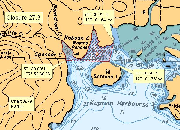
| 27.3 Koprino Harbour, Quatsino Sound | 27.3.png | The waters and intertidal foreshore of western Koprino Harbour, Quatsino Sound, lying inside a line drawn from the entrance to Spencer Cove at 50°30.00 north latitude and 127°52.60 minutes west longitude, thence easterly to the most northern point of Schloss Island at 50°29.99 minutes north latitude and 127°51.76 minutes west longitude, thence northerly to a point on land northwest of Jones Rock at 50°30.22 minutes north latitude and 127°51.64 minutes west longitude. [NAD83] |
| 27.4 Winter Harbour | 27.4.png | The waters and intertidal foreshore of Winter Harbour lying north of a line drawn from Greenwood Point at 50°30.58' north latitude and 128°01.59' west longitude, thence due east to the mouth of Quashtin Creek at 50°30.58' north latitude and 128°01.20' west longitude, and west and south of a line drawn from a point of land east of Galato Creek at 50°31.96' north latitude and 128°00.84' west longitude, thence southeasterly to a point of land on the opposite shore at 50°31.67' north latitude and 128°00.55' west longitude. [NAD83] |
| 27.5 Holberg Inlet | 27.5.png | The waters and intertidal foreshore at the head of Holberg Inlet. [NAD83] |
| 27.6 Hectate Cove, Quatsino Sound | 27.6.png | The waters and intertidal foreshore of Hecate Cove, Quatsino Sound, lying inside a line drawn from the point of land on the eastern side of the entrance to the cove at 50°32.47 minutes north latitude and 127°35.55 minutes west longitude, thence westerly to a point on land on the opposite shore on the western side of the cove at 50°32.47 minutes north latitude and 127°36.06 minutes west longitude. [NAD83] |
| 27.9 Jules Bay | 27.9.png | The waters and intertidal foreshore of Jules Bay, from Dahlstrom Point thence easterly to a point on land at 50 °35.24' north latitude and 127 ° 44.36' west longitude. [NAD83] |
Last updated: 2026-06-09
Related links
- Area maps
- Realtime bivalve shellfish safety harvesting map
- Information about recreational shellfish harvesting in BC
- Shellfish harvesting safety information
- Planned bivalve shellfish harvesting closures
- Identify your catch
Contact us
Email: DFO.PACCSSP-PCAMPAC.MPO@dfo-mpo.gc.ca
- Date modified: