
BC tidal area 29 - Delta, Ladner, Richmond, Tsawwassen: Bivalve shellfish contamination information
Eating contaminated shellfish can make you very sick and can even be life threatening.
Harvesting opportunities and closures change often throughout the year for conservation or public health reasons. Check the table below or our real-time bivalve shellfish safety harvesting map to ensure that it's legal and safe to harvest, every time you head out to fish. If you are a recreational harvester, you also need to review recreational shellfish harvesting opportunities and limits and ensure you are carrying a current tidal waters sport fishing licence.
Because of the risk of sanitary contamination, all bivalve shellfish harvesting is permanently closed within the following boundaries, often marked with signage or red concrete markers:
- 300 metres around industrial, municipal and sewage treatment plant outfall discharges
- 125 metres around a marina, ferry wharf, floating living accommodation, or any finfish net pen
If you are in an aquaculture facility there are some exceptions to the second item.
- 25 metres around any floating living accommodation facility located within a shellfish aquaculture facility where a zero-discharge and appropriate waste management plan is a condition of the Aquaculture Licence and is approved by the Regional Interdepartmental Committee
- 0 metres of any finfish net pen within an aquaculture facility where an Integrated Multi-Trophic Aquaculture Management Plan approved by the Regional Interdepartmental Committee is in operation.
Shellfish aquaculture facilities use markers at the corners of their licensed area.
Bivalve shellfish contamination status
Look at the first column below to see which species are safe to harvest. If there is information in the second column, it is both illegal and unsafe to harvest any bivalve species in those areas.
| Subarea | Marine biotoxin update (open bivalve species) | Sanitary contamination closures (closed to shellfish harvesting) |
|---|---|---|
| 29-1 | Closed to All Bivalve Species | |
| 29-2 | Closed to All Bivalve Species | |
| 29-3 | Closed to All Bivalve Species | |
| 29-4 | Closed to All Bivalve Species | |
| 29-5 | Clam - Butter;Clam - Littleneck;Clam - Manila;Mussels - all species combined;Oyster - Pacific | |
| 29-6 | Closed to All Bivalve Species | |
| 29-7 | Closed to All Bivalve Species | |
| 29-8 | Closed to All Bivalve Species | |
| 29-9 | Closed to All Bivalve Species | |
| 29-10 | Closed to All Bivalve Species | |
| 29-11 | Closed to All Bivalve Species | |
| 29-12 | Closed to All Bivalve Species | |
| 29-13 | Closed to All Bivalve Species | |
| 29-14 | Closed to All Bivalve Species | |
| 29-15 | Closed to All Bivalve Species | |
| 29-16 | Closed to All Bivalve Species | |
| 29-17 | Closed to All Bivalve Species |
Last updated: 2026-07-20
Area descriptions
| Closure | Map | Area description |
|---|---|---|
| 28.3 Gower Point to Soames Point, Gibsons Landing | 28.3.png | The intertidal foreshore from Gower Point to Soames Point, Gibsons Landing. [NAD83] |
| 29.1 Chaster Creek to Gower Point | 29.1.png | The intertidal foreshore from the mouth of Chaster Creek to Gower Point. [NAD83] |
| 29.10 Trail Bay | 29.10.png | The waters and intertidal foreshore of Trail Bay in the area of the District of Sechelt inside a line drawn from a point on land at 49°28.12' north latitude and 123º46.82' west longitude at the end of Norwest Bay Road in Sechelt, southeasterly to a point in the water at 49°27.44' north latitude and 123º45.19' west longitude, thence due east to a point on land at 49°27.44' north latitude and 123º44.29' west longitude located at the end of Nestman Road in Selma Park. [NAD83] |
| 29.2 Boundary Bay, Mud and Semiahmoo Bays | 29.2.png | The waters and intertidal foreshore of Boundary Bay, Mud Bay and Semiahmoo Bay, lying inside, that is northerly of the International Boundary Line. [NAD83] |
| 29.3 Sand Heads to U.S. Boundary by Tsawwassen | 29.3.png | The waters and intertidal foreshore in the Strait of Georgia, lying inside a line drawn from the International Boundary south of Tsawwassen at 49°00.09' north latitude and 123°05.38' west longitude, following the International Boundary through the westerly end of Tsawwassen Causeway to a point in water at 49°00.12' north latitude and 123°09.01' west longitude, thence northwesterly to the light at Sand Heads at 49°06.36' north latitude and 123°18.19' west longitude, thence northwesterly to a point in water at 49°13.09' north latitude and 123°22.71' west longitude, thence northeasterly to the western end of the Fraser River North Arm Jetty at 49°15.54' north latitude and 123°16.97' west longitude, and including the waters of the Fraser River, south of a line drawn from the northern tip of Lulu Island at 49°11.74' north latitude and 122°55.26' west longitude southeasterly to a point on the opposite bank at 49°11.42' north latitude and 122°54.66' west longitude. [NAD83] |
| 29.4 Sargeant Bay, Sechelt Peninsula | 29.4.png | That portion of Sargeant Bay, Sechelt Peninsula, within a 300 m radius of the mouth of the unnamed creek entering the northernmost area of the bay. [NAD83] |
| 29.5 Whaler Bay, Galiano Island | 29.5.png | The waters and intertidal foreshore of Whaler Bay, Galiano Island, lying inside, that is southeast of a line drawn 265° True from Cain Point to the western shore of Galiano Island. [NAD83] |
| 29.6 Whaler Bay, Galiano Island | 29.6.png | The waters and intertidal foreshore of Galiano Island lying west of a line drawn from Twiss Point at 48°53.59' north latitude and 123°20.08' west longitude thence southwesterly to a point of land marking the entrance to Murchison Cove at 48°53.41' north latitude and 123°20.15' west longitude. [NAD83] |
| 29.7 Wakefield Creek | 29.7.png | The intertidal waters at the mouth of Wakefield Creek from a point on land at the base of Mason Road at 49°28.06' north latitude and 123°48.09' west longitude, thence westerly along the edge of the intertidal zone to a point of land at 49°28.07' north latitude and 123°48.48' west longitude. [NAD83] |
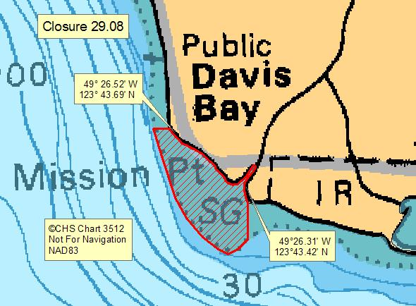
| 29.8 Davis Bay | 29.8.png | The intertidal foreshore of Davis Bay, located southeast of Sechelt, west of a line drawn due south from an unnamed point on the east side of Chapman Creek at 49°26.31' north latitude and 123°43.42' west longitude, thence northerly and westerly along the low tide mark to a point where a line drawn due west from the culvert at 49°26.52' north latitude and 123°43.69' west longitude intersects the low tide mark. [NAD 83] |
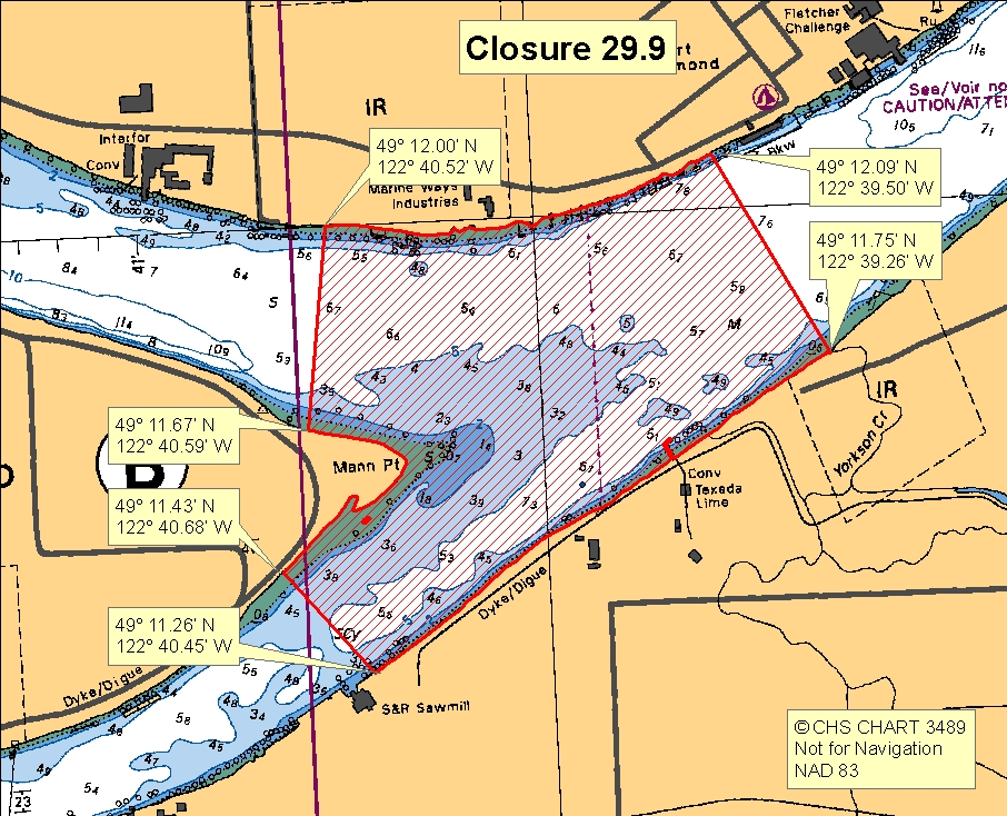
| 29.9 Northwest Langley | 29.9.png | The waters and intertidal foreshore of the Fraser River, lying inside a line drawn from the mouth of Yorkson Creek at 49°11.75' north latitude and 122°39.26' west longitude, thence northwesterly across Derby Reach to a point on land at 49°12.09' north latitude and 122°39.50' west longitude, thence easterly following the shoreline to a point on land at 49°12.00' north latitude and 122°40.52' west longitude, thence southeasterly across Bishops Reach to a point on Barnston Island west of Mann Point at 49°11.67' north latitude and 122°40.59' west longitude, thence westerly following the shoreline to a point on Barnston Island east of Mann Point at 49°11.43' north latitude and 122°40.68' west longitude, thence southeasterly across Parsons Channel to a point on land at 49°11.26' north latitude and 122°40.45' west longitude, thence northeasterly following the shoreline to the point of commencement. [NAD83] |
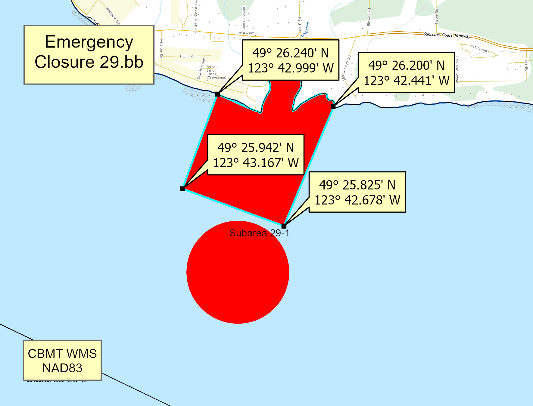
| 29.bb Sechelt, Latsematkwu Wastewater Treatment Plant | 29.bb.jpeg | The waters and intertidal foreshore of Subarea 29-1 south of a line drawn from a point on land at 49° 26.240' N and 123° 42.999' W, thence southwesterly to a point in the water at 49° 25.942' N and 123° 43.167' W, thence southeasterly to a point in the water at 49° 25.825' N and 123° 42.678' W, thence northeasterly to a point of land at 49° 26.200' N and 123° 42.441' W. [NAD 83] |
Last updated: 2026-07-20
Related links
- Area maps
- Realtime bivalve shellfish safety harvesting map
- Information about recreational shellfish harvesting in BC
- Shellfish harvesting safety information
- Planned bivalve shellfish harvesting closures
- Identify your catch
Contact us
Email: DFO.PACCSSP-PCAMPAC.MPO@dfo-mpo.gc.ca
- Date modified: