
Rockfish Conservation Areas
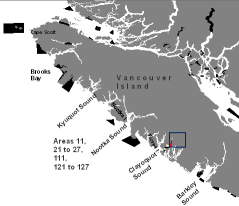
Area 23 - Broken Islands Group - Chart 3602
This map is for information only and should not be used for fishing, navigation or other purposes.
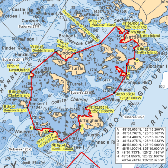
That portion of Subarea 23-8 that lies inside a line that:
| begins at | 48°55.329'N | 125°19.300'W | eastern tip of Dodd Island |
|---|---|---|---|
| then to | 48°55.767'N | 125°17.600'W | northwest tip of Jarvis Island |
| then to | 48°56.533'N | 125°16.537'W | western tip of Prideaux Island |
| then follows the southerly shoreline to | 48°56.400' N | 125°15.867'W | eastern tip of Prideaux Island |
| then true east to | 48°56.300'N | 125°15.600'W | northwest tip of Nettle Island |
| then follows the southerly shoreline to | 48°55.463'N | 125°15.200'W | southern tip of Nettle Island |
| then true south to | 48°55.056'N | 125°15.200'W | Gibraltar Island |
| then follows the westerly shoreline to | 48°54.767'N | 125°15.767'W | southwestern tip of Gibraltar Island |
| then true south to | 48°54.400'N | 125°15.767'W | Dempster Island |
| then follows the eastery shoreline to | 48°54.275'N | 125°15.833'W | southeastern tip of Dempster Island |
| then to | 48°53.500'N | 125°16.600'W | in water |
| then to | 48°52.853'N | 125°18.600'W | northwestern tip of Effingham Island |
| then follows the westerly shoreline to | 48°52.000'N | 125°19.000'W | southwestern tip of Effingham Island |
| then true south to | 48°51.900'N | 125°19.000'W | Austin Island |
| then to | 48°51.300'N | 125°20.283'W | southeastern tip of Howell Island |
| then follows the northerly shoreline to | 48°51.733'N | 125°20.817'W | western tip of Howell Island |
| then true west to | 48°51.733'N | 125°21.186'W | Wouwer Island |
| then follows the northerly shoreline to | 48°51.850'N | 125°22.100'W | western tip of Wouwer Island |
| then to | 48°52.833'N | 125°22.622'W | eastern tip of Benson Island |
| then to | 48°53.317'N | 125°22.376'W | eastern tip of Clarke Island |
| then true north through Owens Island to | 48°54.243'N | 125°22.376'W | southern tip of Lovett Island |
| then follows the easterly shoreline to | 48°54.472'N | 125°22.400'W | northern tip of Lovett Island |
| then to | 48°55.400'N | 125°20.650'W | western tip of Dodds Island |
Regulations
Prohibited fisheries activities
The fisheries activities listed below are restricted in order to help protect rockfish from mortality and to support their conservation. By following regulations in Rockfish Conservation Areas, you are actively helping to protect these species.
Commercial harvesters may not fish for:
- salmon by troll
- groundfish by means of bottom trawl, hook and line, mid-water trawl, or trap
- tuna by hook and line
- shrimp by trawl
Recreational fishers may not fish for:
- any species by spearfishing
- groundfish by angling
- salmon by trolling, jigging or mooching
- octopus by angling
- squid by jigging
Permitted fisheries activities
Some other fisheries activities may be allowed in RCAs. Check our fishery notice system and our sport fishing guide for current details about fishing opportunities, closures and regulations in the area you want to fish in. Make sure you know and follow your conditions of licence every time you head out to fish.
The use of descending devices is mandatory when recreational anglers release rockfish. Learn more about barotrauma and how you can help protect rockfish.
Related links
Click on the map above to see other RCAs in this region.
- Date modified: