
BC tidal area 12 - Port Hardy, Robson Bight: Recreational fishing limits, openings and closures
Licence holders must follow fishing regulations unless otherwise specified in the Conditions of Licence.
How to follow the rules
- Make sure you have a current BC Tidal Waters sport fishing licence with you at all times. Are you using the FishingBC App for electronic licensing and catch recording? Learn more.
- Check the Area map. You need to know the location (subarea) where you plan to fish.
- Check the species regulations tables for fishing opportunities and basic regulations.
- Check the restrictions tables for special exceptions and more detailed regulations. Make sure you know the:
- Daily limit: The maximum number of a given fish species that a person is allowed to keep in one day.
- Possession limit: The maximum number of fish you can have in your possession at any given time, except for what is at your ordinary residence. The possession limit for most species is double the daily limit.
- Annual limit: The total amount of fish of a certain species that may be caught and retained during the course of a fishing year which starts on April 1 and ends the following March 31. Check "Restrictions" under each section for annual limits by species.
- Get to know the locations of protected areas. Permanent fishing restrictions are in effect in these areas to protect fish and fish habitat.
- Unless otherwise specified, fishing opportunities and closures end at 23:59 hrs on the close-date shown.
Related links
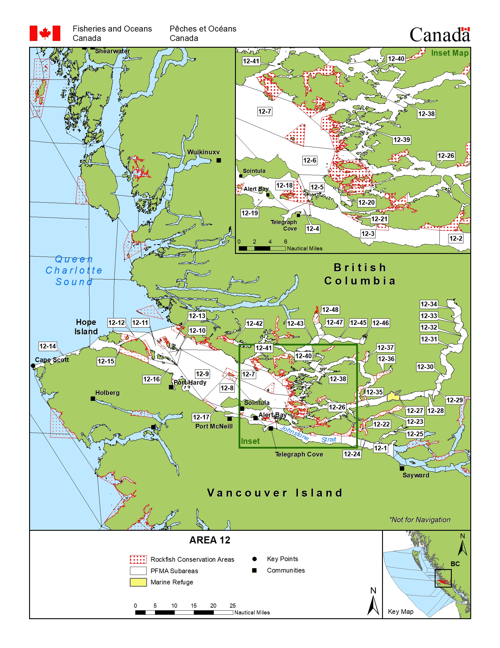
Area map
Area maps
This map is for information only and should not be used for fishing, navigation or other purposes.
For a written description of Areas please see the Pacific Fishery Management Area Regulations 2007.
Area 12: Download a printable PDF version of this map.
Salmon
Salmon
- You must have a valid a salmon conservation stamp on your BC Tidal Waters sport fishing licence if you plan to retain salmon.
- You must immediately and permanently record all retained chinook salmon on your paper licence, your NRLS catch log or your NRLS-linked FishingBC app catch log.
- Learn more about fishing for salmon
Maps
- Management measures to protect Southern Resident killer whales
- Area 12 - Port Hardy, Robson Bight: coho salmon openings and other management measures
Species regulations
Always check for restrictions.
| Species | Areas | Min size | Gear | Daily Limits | Status |
|---|---|---|---|---|---|
| Chinook salmon (hatchery and wild combined) | 12-1 to 12-13,12-15 to 12-26,12-29 to 12-34,12-36,12-37,12-39 and 12-41 to 12-48 | 62cm | barbless hook and line | 0 | Non Retention |
| 12-14 | 45cm | barbless hook and line | 2 | Open | |
| 12-27,12-28,12-35,12-38 and 12-40 | 62cm | barbless hook and line | 1 Combined Total * Consisting of no more than:
|
Open | |
| Chum salmon | 12 | 30cm | barbless hook and line | 0 | Non Retention |
| Coho salmon (hatchery and wild combined) | 12-1,12-2,12-20,12-24 and 12-25 | 30cm | barbless hook and line | 2 Combined Total * Consisting of no more than:
|
Open |
| 12-3 to 12-13,12-15 to 12-19,12-21 to 12-23 and 12-26 to 12-48 | 30cm | barbless hook and line | 2 Combined Total * Consisting of no more than:
|
Open | |
| 12-14 | 30cm | barbless hook and line | 2 | Open | |
| Pink salmon | 12 | 30cm | barbless hook and line | 4 | Open |
| Sockeye salmon | 12 | 30cm | barbless hook and line | 0 | Non Retention |
Last updated: 2025-06-03
Restrictions
Always check for protected areas.
| Species | Areas | Measure type | Measure value |
|---|---|---|---|
| Finfish | Kingcome River | Closed | any gear or method (year round ) |
| Klinaklini River | Closed | any gear or method (year round ) | |
| Nimpkish River | Closed | any gear or method (Jun 1 to Nov 30) | |
| Wakeman Sound | Closed | any gear or method (year round ) | |
| Salmon | Coastwide | Daily Limit Pieces | 4 - The daily limit for all species of Pacific salmon from tidal and fresh waters combined is four. Individual species limits also apply. |
| 12 | Gear Restriction | You are not allowed to harvest using the following gears and methods:
|
|
| Coastwide | Reminder | When Open, the possession limit for salmon is twice the daily limit. | |
| Coastwide | Reminder | Hatchery (marked) salmon - Chinook and coho salmon with a healed scar in place of the adipose fin. | |
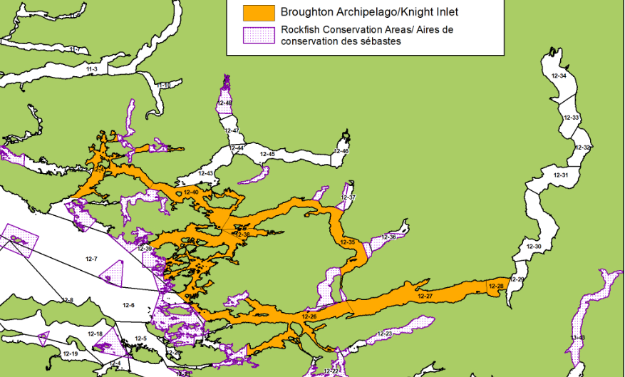
| Chinook salmon (hatchery and wild combined) | Broughton Archipelago and Knight Inlet | Daily Limit Pieces | 1 Combined Total * Consisting of no more than:
|
| Coastwide | Annual Limit Pieces | 10 - The coastwide total annual limit for chinook salmon is 10 from all tidal waters that are open to chinook retention. | |
| Coastwide | Reminder | Keeping your chinook salmon? You must permanently record all retained catch (head-on length) on your Tidal Waters Sport Fishing Licence. The licence holder may alternatively record retained catch immediately in an electronic licence held in an approved third-party application linked to their National Recreational Licensing System (NRLS) account, or if mobile internet access is immediately available, directly in their NRLS account. The licence holder shall ensure that all mandatory catch records for the current licence year are produced, either on the licence (paper or electronic), or from the licence holder's NRLS account at the time of inspection. |
Last updated: 2025-06-03
Area descriptions
| Area | Map | Area description |
|---|---|---|
| Broughton Archipelago and Knight Inlet | Broughton Archipelago and Knight Inlet | Subareas 12-27, 12-28, 12-35, 12-38, and 12-40; and that portion of Subarea 12-26 north of a line from Dinner Point on Village Island at 50°37.628'N, 126°30.322'W across to a point on the opposite shore on Turnour Island at 50°37.536'N, 126°29.845'W; AND east of the Lower Clio RCA boundary line at 50°35.397'N, 126°31.982'W; 50°34.943'N, 126°32.080'W; and that portion of Subarea 12-39 northeast of a line drawn from Gordon Point on Broughton Island at 50°45.885'N, 126°44.158'W across to the RCA boundary on Eden Island at 50°45.510'N, 126°42.831'W; and those portions of Subarea 12-39 east of the Eden-Bonwick-Midsummer-Swanson Islands RCA; and that portion of Subarea 12-41 north of a line from Popplewell Point (50º50.756'N, 126º57.317'W) to the RCA boundary at Bourmaster Point (50º50.700'N, 126º55.574'W); |
| Coastwide | ||
| Kingcome River | Subarea 12-46, the mouth of Kingcome River shoreward of a line from a fishing boundary sign on Petley Point to a fishing boundary sign on a point on the opposite shore of Kingcome Inlet. | |
| Klinaklini River | Subarea 12-34, the waters of the mouth of Klinaklini River (Knight Inlet) shoreward of a line from a fishing boundary sign at the southern entrance to Wahshihlas Bay to a fishing boundary sign at Rubble Point. | |
| Nimpkish River | Subarea 12-19, the mouth of Nimpkish River inside a line from a fishing boundary sign at a point on the shore of Vancouver Island approximately 1.5 km east of Broad Point, then to a navigational aid in the middle of Haddington Passage, then to a fishing boundary sign at a point approximately 1 km east of Willow Creek, then to the tidal water boundary signs approximately 100 m upstream of the Highway 19 bridge. | |
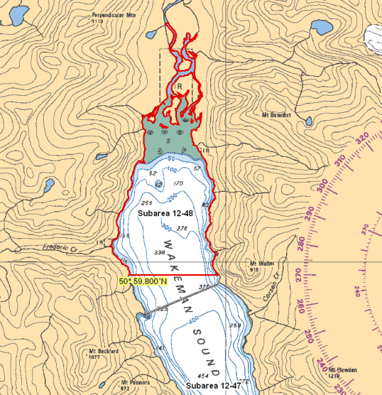
| Wakeman Sound | Wakeman Sound | Subarea 12-48, the mouth of Wakeman River north of a line connecting two fishing boundary signs located on opposite shores approximately 6 km from the head of Wakeman Sound. |
Last updated: 2025-06-03
Other finfish
Finfish other than salmon
- You must immediately and permanently record the following retained catch on your paper licence, your NRLS catch log or your NRLS-linked FishingBC app catch log.
- halibut
- lingcod caught in Areas 12 to 19 (excluding Subarea 12-14) and Subareas 20-5 to 20-7 and 29-5
- Check the Restrictions for the current possession limit for Pacific halibut
- Learn more about fishing for finfish
Species regulations
Always check for restrictions.
| Species | Areas | Min size | Gear | Daily Limits | Status |
|---|---|---|---|---|---|
| Codfish | 12 | angling, spear fishing while diving | 8 | Open | |
| Eulachon | 12 | 0 | Closed | ||
| Finfish - all other species | 12 | angling, dip net, herring jig, herring rake, spear fishing while diving | 20 | Open | |
| Greenling | 12 | angling, spear fishing while diving | 3 | Open | |
| Halibut | 12 | angling, spear fishing while diving | 1 | Open | |
| Herring | 12 | cast net, dip net, herring jig, herring rake | 20kg | Open | |
| Lingcod | 12-1 to 12-13 and 12-15 to 12-48 | 65cm | angling, spear fishing while diving | 1 | Open |
| 12-14 | 65cm | angling, spear fishing while diving | 3 | Open | |
| Mackerel | 12 | angling, dip net, herring jig, spear fishing while diving | 100 | Open | |
| Northern Anchovy | 12 | cast net, dip net, herring jig, herring rake | 20kg | Open | |
| Pacific sand lance | 12 | cast net, dip net, herring jig, herring rake | 5kg | Open | |
| Pacific sardine | 12 | angling, dip net, herring jig, spear fishing while diving | 100 | Open | |
| Rockfish - Yelloweye | 12 | angling, spear fishing while diving | 0 | Non Retention | |
| Rockfish - all species except Yelloweye | 12-1 to 12-13 and 12-15 to 12-48 | angling, spear fishing while diving | 1 | Open | |
| 12-14 | angling, spear fishing while diving | 3 | Open | ||
| Sablefish | 12 | angling | 4 | Open | |
| Sculpin | 12 | angling | 8 | Open | |
| Shark - Basking | 12 | 0 | Closed | ||
| Shark - Blue | 12 | 0 | Closed | ||
| Shark - Brown Cat | 12 | 0 | Closed | ||
| Shark - Great White | 12 | 0 | Closed | ||
| Shark - Salmon | 12 | angling, spear fishing while diving | 1 | Open | |
| Shark - Sixgill | 12 | 0 | Closed | ||
| Shark - Tope | 12 | 0 | Closed | ||
| Shark - all other species | 12 | 0 | Closed | ||
| Skate | 12 | angling | 1 | Open | |
| Smelt | 12 | dip net, gill net | 20kg | Open | |
| Sole or Flounder | 12 | angling, spear fishing while diving | 8 | Open | |
| Spiny Dogfish | 12 | angling, spear fishing while diving | 4 | Open | |
| Surfperch | 12 | angling | 8 | Open | |
| Tuna - Albacore | 12 | angling, spear fishing while diving | 20 | Open | |
| Tuna - Bluefin | 12 | angling, spear fishing while diving | 20 | Open | |
| Tuna - all other species | 12 | angling, spear fishing while diving | 20 | Open | |
| White Sturgeon | 12 | angling | 0 | Non Retention | |
| Wolf Eel | 12 | angling | 0 | Non Retention |
| Species | Areas | Min size | Gear | Daily Limits | Status |
|---|---|---|---|---|---|
| Trout (hatchery and wild combined) | 12 | 30cm | angling | 2 Combined Total * Consisting of no more than:
|
Open |
Last updated: 2025-06-03
Restrictions
Always check for protected areas.
| Species | Areas | Measure type | Measure value |
|---|---|---|---|
| Finfish | Kingcome River | Closed | any gear or method (year round ) |
| Klinaklini River | Closed | any gear or method (year round ) | |
| Nimpkish River | Closed | any gear or method (Jun 1 to Nov 30) | |
| Wakeman Sound | Closed | any gear or method (year round ) | |
| Other Finfish | Coastwide | Reminder | When Open, the possession limit for finfish other than salmon is twice the daily limit – except for Halibut (see Restrictions section). |
| Herring | Coastwide | Reminder | Harvesting of herring roe from marine plants or plants placed in the water for the purpose of harvesting herring roe is prohibited. |
| Eulachon | Coastwide | Closed | Due to conservation concerns the harvesting of eulachon is prohibited. |
| Codfish | Coastwide | Reminder | Species includes - Pacific cod, Pacific tomcod, pollock and hake but does not include lingcod. |
| Halibut | Coastwide | Annual Limit Pieces | 10 - The coastwide total annual limit for halibut is 10 from all tidal waters that are open to halibut retention. |
| Coastwide | Maximum Length Head On (cm) | 102 - The maximum overall length for halibut is 102 cm head-on, or 78 cm head-off. | |
| Coastwide | Reminder | As a Condition of Licence, the possession limit is one (1) halibut. No person shall retain a halibut greater than 102 cm head-on length (78 cm head-off). Head-off measurements are made from the base of the pectoral fin at its most forward point to the extreme end of the middle of the tail. | |
| Coastwide | Reminder | You must permanently record all retained catch (head-on length) on your Tidal Waters Sport Fishing Licence. The licence holder may alternatively record retained catch immediately in an electronic licence held in an approved third-party application linked to their National Recreational Licensing System (NRLS) account, or if mobile internet access is immediately available, directly in their NRLS account. The licence holder shall ensure that all mandatory catch records for the current licence year are produced, either on the licence (paper or electronic), or from the licence holder's NRLS account at the time of inspection. | |
| Lingcod | 12-1 to 12-13 and 12-15 to 12-48 | Annual Limit Pieces | 10 - The total annual limit for lingcod is 10 from the following tidal areas when they are open to lingcod retention - Areas 12 to 19 (excluding Subarea 12-14), Subareas 20-5 to 20-7, and 29-5. |
| 12 | Reminder | Lingcod - Fillets, including the tail, must meet the minimum "head off" size limit of 53 cm (21 in). | |
| 12-1 to 12-13 and 12-15 to 12-48 | Reminder | Areas 12 to 19 (excluding Subarea 12-14), Subareas 20-5 to 20-7, and 29-5 - You must permanently record all retained catch on your Tidal Waters Sport Fishing Licence. The licence holder may alternatively record retained catch immediately in an electronic licence held in an approved third-party application linked to their National Recreational Licensing System (NRLS) account, or if mobile internet access is immediately available, directly in their NRLS account. The licence holder shall ensure that all mandatory catch records for the current licence year are produced, either on the licence (paper or electronic), or from the licence holder's NRLS account at the time of inspection. | |
| Coastwide | Season Planning | For planning purposes only: For in-season requirements, please see current regulations/restrictions for specific areas, gear and individual species limits, and closures/exceptions. INSIDE WATERS - Generally open May 1 to September 30, for Areas 13 to 19 and Subareas 12-1 to 12-13, 12-15 to 12-48, 20-5 to 20-7 and 29-5. Closed year round - Area 28 and Subareas 29-1 to 29-4 and 29-6 to 29-17. OUTSIDE WATERS - Generally open April 1 to November 15, for Areas 1 to 10, 101 to 110, 130, 142, 11, 21 to 27, 111, 123 to 127, Subareas 12-14 and 20-1 to 20-4, and Area 121 (portion). | |
| Perch | Coastwide | Reminder | Includes kelp, shiner and pile perch, and all species of surf and sea perch. |
| Rockfish | Coastwide | Reminder | Anglers in vessels shall immediately return all rockfish that are not being retained to the water and to a similar depth from which they were caught by use of an inverted weighted barbless hook or other purpose-built descender device. |
| Coastwide | Season Planning | For planning purposes only: For in-season requirements, please see current regulations/restrictions for specific areas, gear and individual species limits, and closures/exceptions. INSIDE WATERS - Generally open May 1 to September 30, for Areas 13 to 19 and Subareas 12-1 to 12-13, 12-15 to 12-48, 20-5 to 20-7 and 29-5. Closed year round - Area 28 and Subareas 29-1 to 29-4 and 29-6 to 29-17. OUTSIDE WATERS - Generally Open April 1 to November 15, for Areas 1 to 10, 101 to 110, 130, 142, 11, 21 to 27, 111, 123 to 127, Subareas 12-14 and 20-1 to 20-4, and Area 121 (portion). | |
| Rockfish - all species except Yelloweye | 12-14 | Daily Limit Pieces | 3 - daily limit of 3 Rockfish per day, of which only 1 may be a China Rockfish, Tiger Rockfish or a Quillback Rockfish. |
| Sculpin | Coastwide | Reminder | Cabezon is a species of sculpin; for daily and possession limits, please see the species regulations table above for sculpin. |
| Trout (hatchery and wild combined) | Coastwide | Reminder | Note: (1) Trout - means Brook trout, Brown trout, Cutthroat trout, Dolly Varden, Lake trout, Rainbow trout, Steelhead, and includes Bull trout. (2) Steelhead - in waters where anadromous Rainbow trout are found, Steelhead means a Rainbow trout that is greater than 50cm in overall length. (3) Anadromous means migrating from the sea up rivers or streams to spawn. |
Last updated: 2025-06-03
Area descriptions
| Area | Map | Area description |
|---|---|---|
| Coastwide | ||
| Kingcome River | Subarea 12-46, the mouth of Kingcome River shoreward of a line from a fishing boundary sign on Petley Point to a fishing boundary sign on a point on the opposite shore of Kingcome Inlet. | |
| Klinaklini River | Subarea 12-34, the waters of the mouth of Klinaklini River (Knight Inlet) shoreward of a line from a fishing boundary sign at the southern entrance to Wahshihlas Bay to a fishing boundary sign at Rubble Point. | |
| Nimpkish River | Subarea 12-19, the mouth of Nimpkish River inside a line from a fishing boundary sign at a point on the shore of Vancouver Island approximately 1.5 km east of Broad Point, then to a navigational aid in the middle of Haddington Passage, then to a fishing boundary sign at a point approximately 1 km east of Willow Creek, then to the tidal water boundary signs approximately 100 m upstream of the Highway 19 bridge. | |
| Wakeman Sound | Wakeman Sound | Subarea 12-48, the mouth of Wakeman River north of a line connecting two fishing boundary signs located on opposite shores approximately 6 km from the head of Wakeman Sound. |
Last updated: 2025-06-03
Bivalve shellfish and snails
Bivalve shellfish and snails
Eating contaminated shellfish can be life threatening. Closures change frequently throughout the year. It is illegal to harvest shellfish from closed or contaminated areas.
Bivalve shellfish have 2 hinged shells. Because they feed by filtering microscopic plankton from the water, changes in water quality can cause unsafe marine biotoxins, bacteria, or viruses to build up in their tissue.
Snails refers to all snails, whelks, tritons and periwinkles with the exception of Moon Snails. Snails and moon snails can accumulate toxins and pollutants. We recommend that they not be harvested from areas shown as closed in the table below.
Learn more about shellfish harvesting.
How to follow the rules
- Check for contamination in the subarea where you plan to harvest. You can also see this in a map format by using our our real-time bivalve shellfish safety harvesting map.
- If no contamination closures are in effect, check species regulations and additional harvest restrictions.
- You are not allowed to harvest within the boundaries of an aquaculture facility. See our interactive map for currently licensed bivalve aquaculture facility locations or, where available, refer to signs and markers on the beach.
- Littleneck, Manila and butter clams are subject to a minimum size limit. See below under restrictions for more information on clam size limits.
- Questions? Email us at DFO.PACCSSP-PCAMPAC.MPO@dfo-mpo.gc.ca.
Bivalve shellfish contamination closures
Planned bivalve shellfish harvesting closures
Look at the first column below to see which species are safe to harvest. If there is information in the second column, it is illegal and unsafe to harvest any bivalve species in those areas.
| Subarea | Marine biotoxin update (open bivalve species) | Sanitary contamination closures (closed to shellfish harvesting) |
|---|---|---|
| 12-1 | Closed to All Bivalve Species | |
| 12-2 | Closed to All Bivalve Species | |
| 12-3 | Closed to All Bivalve Species | |
| 12-4 | Closed to All Bivalve Species | |
| 12-5 | Closed to All Bivalve Species | |
| 12-6 | Closed to All Bivalve Species | |
| 12-7 | Closed to All Bivalve Species | |
| 12-8 | Closed to All Bivalve Species | |
| 12-9 | Closed to All Bivalve Species | |
| 12-10 | Closed to All Bivalve Species | |
| 12-11 | Closed to All Bivalve Species | |
| 12-12 | Closed to All Bivalve Species | |
| 12-13 | ||
| 12-14 | Closed to All Bivalve Species | |
| 12-15 | Closed to All Bivalve Species | |
| 12-16 | Closed to All Bivalve Species | |
| 12-17 | Closed to All Bivalve Species | |
| 12-18 | Closed to All Bivalve Species | |
| 12-19 | Closed to All Bivalve Species | |
| 12-20 | Closed to All Bivalve Species | |
| 12-21 | Closed to All Bivalve Species | |
| 12-22 | Closed to All Bivalve Species | |
| 12-23 | Closed to All Bivalve Species | |
| 12-24 | Closed to All Bivalve Species | |
| 12-25 | Closed to All Bivalve Species | |
| 12-26 | Closed to All Bivalve Species | |
| 12-27 | Closed to All Bivalve Species | |
| 12-28 | Closed to All Bivalve Species | |
| 12-29 | Closed to All Bivalve Species | |
| 12-30 | Closed to All Bivalve Species | |
| 12-31 | Closed to All Bivalve Species | |
| 12-32 | Closed to All Bivalve Species | |
| 12-33 | Closed to All Bivalve Species | |
| 12-34 | Closed to All Bivalve Species | |
| 12-35 | Closed to All Bivalve Species | |
| 12-36 | Closed to All Bivalve Species | |
| 12-37 | Closed to All Bivalve Species | |
| 12-38 | Closed to All Bivalve Species | |
| 12-39 | ||
| 12-40 | Closed to All Bivalve Species | |
| 12-41 | Closed to All Bivalve Species | |
| 12-42 | Closed to All Bivalve Species | |
| 12-43 | Closed to All Bivalve Species | |
| 12-44 | Closed to All Bivalve Species | |
| 12-45 | Closed to All Bivalve Species | |
| 12-46 | Closed to All Bivalve Species | |
| 12-47 | Closed to All Bivalve Species | |
| 12-48 | Closed to All Bivalve Species |
Last updated: 2025-06-03
Species regulations
Always check for restrictions.
| Species | Areas | Gear | Daily Limits |
|---|---|---|---|
| Clam - Butter | 12 | hand digging, hand picking | 20 |
| Clam - Horse | 12 | hand digging, hand picking | 6 |
| Clam - Littleneck | 12 | hand digging | 60 |
| Clam - Manila | 12 | hand digging | 60 |
| Clam - Razor | 12 | hand digging | 12 |
| Clam - Softshell | 12 | hand digging | 25 |
| Clam - Varnish | 12 | hand digging | 60 |
| Clam - all species combined | 12 | hand digging, hand picking | 60 |
| Cockles | 12 | hand digging, hand picking | 25 |
| Geoduck | 12 | hand digging, hand picking | 3 |
| Mussel - Blue | 12 | hand picking | 75 |
| Mussel - California | 12 | hand picking | 25 |
| Mussels - all species combined | 12 | hand picking | 75 |
| Oyster - Olympia | 12 | 0 | |
| Oyster - all species except Olympia | 12 | hand picking | 12 |
| Scallop - Pink and Spiny | 12 | hand picking, hand picking while diving | 75 |
| Scallop - Purple-hinged rock | 12 | hand picking, hand picking while diving | 6 |
| Scallop - Weathervane | 12 | hand picking, hand picking while diving | 6 |
| Scallop - Weathervane and Purple-hinged rock combined | 12 | hand picking, hand picking while diving | 6 |
| Snail - Moon | 12 | hand picking | 2 |
| Snail - other | 12 | hand picking | 75 |
| Whelks | 12 | hand picking | 75 |
Last updated: 2025-06-03
Restrictions
Always check for protected areas.
| Species | Areas | Measure type | Measure value |
|---|---|---|---|
| Bivalve Species | Coastwide | Reminder | Because of the risk of contamination, you are not allowed to harvest bivalve shellfish (for any purpose) within: (1) 300 metres around industrial, municipal and sewage treatment plant outfall discharges (2) 125 metres around a marina, ferry wharf, floating living accommodation, or any finfish net pen (exceptions described as follows) (3) 25 meters around any floating living accommodation facility located within a shellfish aquaculture tenure where a zero-discharge and appropriate waste management plan is a condition of the Aquaculture Licence and is approved by the Regional Interdepartmental Committee (4) 0 meters of any finfish net pen within an aquaculture tenure where an Integrated Multi-Trophic Aquaculture Management Plan approved by the Regional Interdepartmental Committee is in operation. |
| Coastwide | Reminder | Only aquaculture operators are allowed to harvest within the boundaries of licenced aquaculture facilities. Please be aware of the location of aquaculture facilities in the areas close to where you are intending to harvest. | |
| Coastwide | Reminder | Clams - No person shall retain a Manila Clam or Littleneck Clam smaller than 35 mm, nor a Butter Clam smaller than 55 mm. | |
| Coastwide | Reminder | When Open, the possession limit for bivalve shellfish is twice the daily limit. | |
| Clam - all species combined | Coastwide | Daily Limit Pieces | 60 - When open, all species aggregate daily limit combined Areas 1 to 27 is 60, except Pacific Rim National Park where the all-species aggregate limit is 24. |
| 12 | Reminder | Clam harvesters are encouraged to fill in holes to reduce predation on exposed juvenile clams. | |
| 12 | Reminder | It is illegal to use any mechanical apparatus or dredge for harvesting clams. | |
| Mussels - all species combined | 12 | Reminder | Combined daily limit for all mussel species is 75. |
| Oyster - all species except Olympia | 12 | Packaging and Transporting | Avoid transfer of green crab - Harvesters are encouraged to shuck oysters on the beach and leave the shells there, or return oyster shells to the beach from where you collected them whenever possible. In order to avoid the transfer of European green crab, please dispose of any oyster shell harvested from the west coast of Vancouver Island back to the beach from where it came or with your household garbage. Consult your local DFO Office. You will need permission to harvest oysters from marked oyster farms. |
| Coastwide | Reminder | To avoid inadvertently harvesting Olympia oysters while you are harvesting Pacific oysters, do not harvest any oyster less than 5 cm in diameter. | |
| Snail - Moon | 12 | Reminder | Moon snails may be subject to PSP, check for closures. Consult your local DFO office for details. |
Last updated: 2025-06-03
Area descriptions
| Closure | Map | Area description |
|---|---|---|
| 12.1 Hardy Bay | 12.1.png | That portion of Hardy Bay lying inside a straight line drawn from Daphne Point on the east side of Hardy Bay to the prominent point of land just north of Scotia Bay at 50°44.83' north latitude and 127°29.68' west longitude. [NAD83] |
| 12.10 Little Nimmo Bay | 12.10.png | The waters and intertidal foreshore of Little Nimmo Bay located east of a line drawn from the headland on the south side of the bay at 50°56.30' north latitude and 126°41.25' west longitude, thence northerly to a point on the northern shore at 50°56.40' north latitude and 126°41.25' west longitude. [NAD83] |
| 12.12 Sutherland Bay, Drury Inlet | 12.12.png | The waters and intertidal foreshore of the southwestern head of Sutherland Bay, Drury Inlet, located inside a line drawn from the rock shoal on the southern foreshore, thence to the rock shoal on the northern foreshore. [NAD83] |
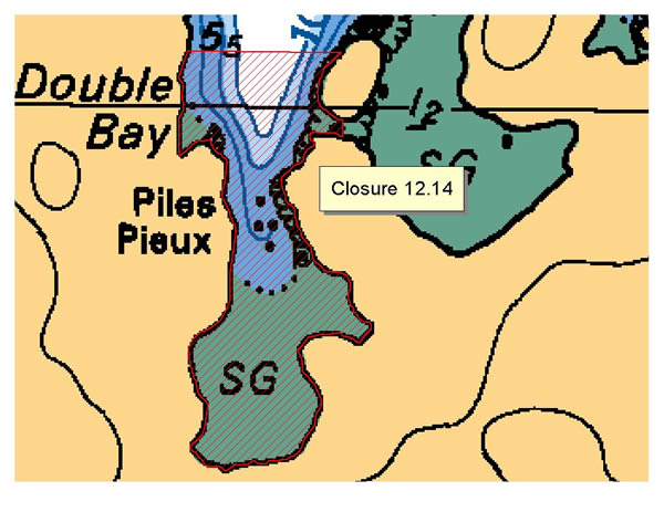
| 12.14 Double Bay, Hanson Island | 12.14.png | The waters and intertidal foreshore of the western bay of Double Bay, Hanson Island, lying inside a line drawn from a point on shore 200 m north of the Double Bay resort due east to an unnamed island and from the southernmost tip of the unnamed island due south to the opposite shore. [NAD83] |
| 12.15 Alert Bay, Cormorant Island | 12.15.png | The waters and intertidal foreshore of Alert Bay, Cormorant Island, inside a line drawn from the navigational light at Yellow Bluff, thence southeast to the cable crossing sign at 50°34.65' north latitude and 126°55.30' west longitude, thence eastward along the foreshore of Gordon Bluff to the end of Fir Street. [NAD83] |
| 12.16 North Side, Cormorant Island | 12.16.png | The waters and intertidal foreshore of Cormorant Island and Cormorant Channel inside a line commencing at the westernmost point of Cormorant Island at 50°35.62' north latitude and 126°57.54' west longitude thence due north to the parallel passing through 50°36.50' north latitude, thence due east to a point in water at 50°36.50' north latitude and 126°54.33' west longitude, thence due south to the foot of Fir St. on Cormorant Island at 50°34.74' north latitude and 126°54.33' west longitude. [NAD83] |
| 12.17 Clam Cove, Nigei Island | 12.17.png | The waters and intertidal foreshore of a bay locally known as Clam Cove, on Nigei Island, lying inside a line drawn from the north side at 50º52.20' north latitude and 127º40.35' west longitude thence easterly to a point on land at 50º52.15' north latitude and 127º40.29' west longitude. [NAD83] |
| 12.2 Echo Bay, Gilford Island | 12.2.png | The waters and intertidal foreshore of Echo Bay, Gilford Island, lying within 300 m of any part of the boat moorage. [NAD83] |
| 12.21 Dixon Island | 12.21.png | The waters and intertidal foreshore of the unnamed bay on the north-easterly shore of Dickson Island, lying inside of a line drawn from a point on land at 50°50.33' north latitude and 126°55.58' west longitude, thence southerly to a point on land at 50°50.22' north latitude and 126°55.60' west longitude. [NAD83] |
| 12.22 Shushartie Bay | 12.22.png | The waters and intertidal foreshore of Shushartie Bay at the northern end of Vancouver Island, inside of a line drawn across the mouth of the bay from a point on land located at 50°51.71' north latitude and 127°52.24' west longitude thence southeasterly to a point on land at 50°51.29' north latitude and 127°51.32' west longitude. [NAD83] |
| 12.25 Duval Island | 12.25.png | The waters and intertidal foreshore of the unnamed bay west of Duval Island, lying west of a line commencing from a point of land at 50°46.28' north latitude and 127°30.64' west longitude, thence southeasterly to a point of land on the west side of Duval Island at 50°46.20' north latitude and 127°30.51' west longitude, and thence due south to a point on land at 50°46.11' north latitude and 127°30.51' west longitude. [NAD83] |
| 12.26 Lagoon Cove | 12.26.png | The waters and intertidal foreshore of Lagoon Cove, north of a line drawn from the southernmost point of Farquharson Island at 50°35.57' north latitude and 126°18.73' west longitude true east to a point of land on East Cracroft Island at 50°35.57' north latitude and 126°18.54' west longitude; and southeast of a line drawn from a point of land at 50°36.07' north latitude and 126°18.86' west longitude in a southwesterly direction to a point of land at the northern entrance to the unnamed cove on the east side of Farquharson Island at 50°35.91' north latitude and 126°19.18' west longitude. [NAD83] |
| 12.27 Keogh River | 12.27.png | The waters and intertidal foreshore at the mouth of the Keogh River, from a fishing boundary sign west of the river mouth at 50°40.75' north latitude and 127°21.18' west longitude, thence southeasterly to a point on land east of the mouth of the river mouth at 50°40.59' north latitude and 127°20.64' west longitude. [NAD83] |
| 12.28 Port Harvey, East Cracroft Island | 12.28.png | The waters and intertidal foreshore of Port Harvey, West Cracroft Island, inside a line drawn from the point of land on the southern shore at the eastern entrance to Cracroft Inlet at 50°34.06' north latitude and 126°16.50' west longitude, thence southeasterly to a debris pile on the western shore of Range Island at 50°33.84' north latitude and 126°16.28' west longitude, thence southwesterly to a point of land south of Tide Pole Islet at 50°33.54' north latitude and 126°16.72' west longitude, thence northerly along the intertidal foreshore to the commencement point. [NAD83] |
| 12.3 Beaver Harbour | 12.3.png | The waters and intertidal foreshore of Beaver Harbour, near Port Hardy, lying inside a straight line drawn from Thomas Point through Cormorant Rock to the shore of Vancouver Island, but not including the small unnamed island immediately to the south of Shell Island. [NAD83] |
| 12.30 Dickson Island | 12.30.png | The intertidal foreshore of southwestern Dickson Island inside a line drawn from a point on land at 50°50.10' north latitude and 126°56.69' west longitude, thence southeasterly to a point of land at 50°50.01' north latitude and 126°56.49' west longitude. [NAD83] |
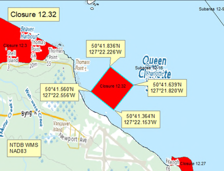
| 12.32 Port Hardy Airport | 12.32.png | Those portions of Subarea 12-16 seaward of the Port Hardy Airport inside a line drawn from a point in the water at 50°41.560' north latitude and 127°22.556' west longitude, thence northeasterly to a point in the water at 50°41.836' north latitude and 127°22.226' west longitude, thence southeasterly to a point in the water at 50°41.639' north latitude and 127°21.820' west longitude, thence southwesterly to a point in the water at 50°41.364' north latitude and 127°22.153' west longitude, thence northwesterly back to the point of commencement. [NAD 83] |
| 12.33 West side of Forward Bay, West Cracroft Island | 12.33.png | The waters and intertidal foreshore of the west side of Forward Bay on West Cracroft Island, inside a line drawn from a point on land at 50°31.27' north latitude and 126°24.42' west longitude, thence southwesterly to a point of land at 50°30.99' north latitude and 126°24.96' west longitude. [NAD83] |
| 12.35 A portion of Clio Channel | 12.35.png | The waters and intertidal foreshore of the channel lying southwest of a line between Farquharson and Dorman Islands in Clio Channel drawn from a point of land on the northern tip of Farquharson Island at 50°36.11' north latitude and 126°19.50' west longitude, thence northwesterly to a point of land on the northeast side of Dorman Island at 50°36.20' north latitude and 126°19.86' west longitude, thence following the high tide mark southwesterly to and across the isthmus between the two islands and back northeasterly to the point of commencement. [NAD83] |
| 12.5 Hopetown Passage, Watson Island | 12.5.png | The waters and intertidal foreshore of Hoy Bay, Watson Island, lying north of a line drawn from Hopetown Point on Watson Island at 50°55.21' north latitude and 126°50.17' west longitude to an unnamed point on Watson Island at 50°55.25' north latitude and 126°49.30' west longitude. [NAD83] |
| 12.6 Macgowan Bay, Drury Inlet | 12.6.png | The waters and intertidal foreshore of Macgowan Bay, Drury Inlet, lying inside a line drawn from a point on shore at 50°54.82' north latitude and 127°08.72' west longitude, thence southeasterly to 50°54.65' north latitude and 127°08.40' west longitude on the opposite shore. [NAD83] |
| 12.7 Bay West of Everard Islets, Drury Inlet | 12.7.png | The waters and intertidal foreshore of a small unnamed bay, immediately west of the Everard Islets, Drury Inlet, lying inside a line drawn from a point on shore at 50°53.38' north latitude and 127°02.83' west longitude, thence easterly to a point on shore at 50°53.36' north latitude and 127°02.58' west longitude. [NAD83] |
| 12.8 Shoal Harbour, Gilford Island | 12.8.png | The waters and intertidal foreshore of Shoal Harbour, Gilford Island, lying inside a line drawn from a point on the west shore at 50°44.59' north latitude and 126°30.30' west longitude thence easterly to a point on shore at 50°44.59' north latitude and 126°30.12' west longitude. [NAD83] |
| 12.A Cutter Cove | 12.A.png | The waters and intertidal foreshore of Cutter Cove lying east of a line drawn from the southern headland of the cove, thence northerly to the westernmost point on the northern headland. [NAD83] |
| 12.jj Port Harvey | 12.jj.png | Harvesting of bivalve shellfish is prohibited in the waters and intertidal foreshore of Port Harvey inside a line drawn from Harvey Point at 50°32.09' north latitude and 126°16.64' west longitude, thence due west to the point on land on West Cracroft Island at 50°32.09' north latitude and 126°18.16' west longitude, thence northeasterly following the shoreline to the point on land at 50°34.10' north latitude and 126°16.52' west longitude, thence north to the point on land on East Cracroft Island at 50°34.13' north latitude and 126°16.51' west longitude, thence following the shoreline back to the point of commencement. [NAD83]. |
| 12-13.A | 12-13.A.png | The waters and intertidal foreshore of that portion of Subarea 12-13 west of a line drawn at 50°55.029' N 127°21.956' W then south intersecting the boundary with Subarea 12-7 at 50°52.317' N 127°21.956' W. [NAD 83] |
| 12-13.B | 12-13.B.png | The waters and intertidal foreshore of that portion of Subarea 12-13 east of a line drawn at 50°55.029' N 127°21.956' W then south intersecting the boundary with Subarea 12-7 at 50°52.317' N 127°21.956' W. [NAD 83] |
| 12-39.A | 12-39.A.png | That portion of Subarea 12-39 North of a line drawn at Sharp Point on Broughton Island at (50° 47.467'N, 126° 36.090' W) proceeding westerly down Fife Sound into Nowell Channel intersecting the boundary with PFMA 12-7 at (50° 45.006' N, 126° 47.224' W). |
| 12-39.B | 12-39.B.png | That portion of Subarea 12-39 South of a line drawn at Sharp Point on Broughton Island at (50° 47.467'N, 126° 36.090' W) proceeding westerly down Fife Sound into Nowell Channel intersecting the boundary with PFMA 12-7 at (50° 45.006' N, 126° 47.224' W). |
Last updated: 2025-06-03
| Area | Map | Area description |
|---|---|---|
| Coastwide |
Last updated: 2025-06-03
Crab
Crab
- It is illegal to possess female Dungeness, King, Puget Sound King, Brown Box and Red Rock crabs. Female crabs must be released immediately. New
- Invasive European green crab
- Learn more about fishing for crab
Species regulations
Always check for restrictions.
| Species | Areas | Min size | Gear | Daily Limits | Status |
|---|---|---|---|---|---|
| Crab - Box | 12 | dip net, hand picking, hand picking while diving, ring net, trap | 1 | Open | |
| Crab - Dungeness | 12 | 165mm | dip net, diving, hand picking, ring net, trap | 4 | Open |
| Crab - Dungeness and Red Rock combined | 12 | dip net, hand picking, hand picking while diving, ring net, trap | 4 | Open | |
| Crab - King | 12 | 0 | Closed | ||
| Crab - Puget Sound King | 12 | dip net, hand picking, hand picking while diving, ring net, trap | 1 | Open | |
| Crab - Red Rock | 12 | 115mm | dip net, diving, hand picking, ring net, trap | 4 | Open |
| Crab - Shore | 12 | hand picking | 75 | Open | |
| Crab - other | 12 | dip net, diving, hand picking, ring net, trap | 4 | Open |
Last updated: 2025-06-03
Restrictions
Always check for protected areas.
| Species | Areas | Measure type | Measure value |
|---|---|---|---|
| Crab | Coastwide | Reminder | As per the British Columbia Sport Fishing Regulations, 1996 - Traps must be marked with a tag, float or buoy that has your name and telephone number on it. This includes traps tied to a boat or dock or fished from shore. If two traps are attached to one ground-line, it is sufficient to attach a tag, float or buoy that bears the operator's name and telephone number to one end of the ground-line. |
| Coastwide | Reminder | As a Condition of Licence, crab traps are required to have two unobstructed circular escape holes or rings, measuring a minimum of 105 mm in diameter. | |
| Coastwide | Reminder | Rot Cord - As per the British Columbia Sport Fishing Regulations, 1996, all crab traps must have a section in the top or sidewall that has been secured by a single length of untreated cotton twine no greater than No. 120 (approximately 5 mm or 3/16 inch diameter). This twine is often referred to as rot cord. On deterioration this must produce a rectangular opening with a minimum size of 7 cm x 20 cm, or a square opening with a minimum size of 11 cm x 11 cm. This regulation is intended to ensure that if the trap is lost, the section secured by the cord will rot, allowing captive crabs to escape, and preventing the trap from continuing to fish. On traps with a rigid frame and a freely opening hinged lid, the trap lid must be secured by a single length of untreated cotton twine no greater than No. 120 so that the trap lid will open freely when the rot cord is broken. No other fastenings may impede the hinged lid of the trap from opening. | |
| Coastwide | Reminder | Crab, prawn and shrimp floats - As a Condition of Licence, the primary float attached to crab traps must be cylindrical in shape (includes bullet shaped) and a minimum of 27 cm in length and 12 cm in diameter; an optional secondary float may be used of any shape or size other than spherical. The primary float attached to prawn and shrimp traps must be spherical in shape and a minimum of 27 cm in diameter; an optional secondary float may be used of any shape or size other than cylindrical. | |
| Coastwide | Reminder | Keep navigation channels clear of buoys and lines. Any fishing gear that interferes with safe navigation can be removed under the Navigation Protection Act. | |
| Coastwide | Reminder | Floats must be made of a durable material and suitable for operation in marine waters. Floats/materials not suitable for use in marine waters are prohibited. | |
| Coastwide | Reminder | When Open, the possession limit for crab is twice the daily limit. | |
| Coastwide | Reminder | As per the British Columbia Sport Fishing Regulations, 1996 - Maximum of 2 ring nets, dip nets or traps or combination of these per fisher. Ensure gear is properly marked. Hand picking is permitted including by diving. No sharp-pointed instruments are permitted for harvesting crab. It is illegal to use snares in catching or attempting to catch crabs. | |
| Coastwide | Reminder | As per the British Columbia Sport Fishing Regulations, 1996 - A line or rope attached to a trap must be submerged in such a manner that the line or rope does not come into contact with a person or a boat. | |
| 12 | Season Planning | The Dungeness and red rock crab limit is reduced to 2 per day and only dip nets, ring nets or hand picking is permitted to harvest crab in in the following area from June 15 to September 14: Subarea 12-19, the mouth of Nimpkish River inside a line from a fishing boundary sign at a point on the shore of Vancouver Island approximately 1.5 km east of Broad Point, then to a navigational aid in the middle of Haddington Passage, then to a fishing boundary sign at a point approximately 1 km east of Willow Creek, then to the tidal water boundary signs approximately 100 m upstream of the Highway 19 bridge. | |
| Crab - Dungeness | Coastwide | Packaging and Transporting | In order to be accurately measured, the carapace of Dungeness crab that you catch must remain attached until the crab arrives at your residence or it is consumed. |
| Coastwide | Sex Restriction | It is prohibited to possess female Dungeness crab. | |
| Crab - Red Rock | Coastwide | Packaging and Transporting | In order to be accurately measured, the carapace of Red Rock crab that you catch must remain attached until the crab arrives at your residence or it is consumed. |
| Coastwide | Sex Restriction | It is prohibited to possess female Red Rock crab. | |
| Crab - King | Coastwide | Packaging and Transporting | In order to be accurately measured, the carapace of King crab that you catch must remain attached until the crab arrives at your residence or it is consumed. |
| Coastwide | Sex Restriction | It is prohibited to possess female King crab. | |
| Crab - Puget Sound King | Coastwide | Sex Restriction | As a Condition of Licence, it is prohibited to possess female Puget Sound King Crab. |
| Crab - Brown Box | Coastwide | Sex Restriction | As a Condition of Licence, it is prohibited to possess female Brown Box Crab. |
Last updated: 2025-06-03
Area descriptions
| Area | Map | Area description |
|---|---|---|
| Coastwide |
Last updated: 2025-06-03
Other invertebrates
Other invertebrates
- Basic information about shellfish harvesting
- Seasonal recreational harvesting closures for prawn and shrimp
Species regulations
Always check for restrictions.
| Species | Areas | Gear | Daily Limits | Status |
|---|---|---|---|---|
| Abalone | 12 | 0 | Closed | |
| Barnacles - Giant | 12 | diving | 6 | Open |
| Barnacles - Goose | 12 | hand picking | 2kg | Open |
| Invertebrates - all other species | 12 | angling, dip net, hand digging, hand picking, hand picking while diving, hand picking while snorkeling, hand pump, ring net, spear fishing while diving, trap | 20 | Open |
| Limpet | 12 | hand picking | 75 | Open |
| Octopus | 12 | angling, hand picking, hand picking while diving, trap | 1 | Open |
| Sand Dollar | 12 | hand picking | 6 | Open |
| Sea Cucumber | 12 | hand picking, hand picking while diving | 12 | Open |
| Sea Star or Starfish | 12 | diving, hand picking | 6 | Open |
| Sea Urchin | 12 | hand picking, hand picking while diving | 12 | Open |
| Shellfish - all other species | 12 | angling, dip net, hand digging, hand picking, hand picking while diving, hand pump, ring net, spear fishing while diving, trap | 20 | Open |
| Shrimp - Ghost | 12 | hand digging, hand pump | 50 | Open |
| Shrimp including prawn | 12 | ring net, spear fishing while diving, trap | 125 | Open |
| Squid - Opal | 12 | cast net, jigging | 200 | Open |
| Squid - all other species | 12 | cast net, jigging | 20 | Open |
Last updated: 2025-06-03
Restrictions
Always check for protected areas.
| Species | Areas | Measure type | Measure value |
|---|---|---|---|
| Other Invertebrates | Coastwide | Reminder | Rot Cord - As per the British Columbia Sport Fishing Regulations, 1996, all open mesh octopus traps and shrimp/prawn traps must have a section in the top or sidewall that has been secured by a single length of untreated cotton twine no greater than No. 120 (approximately 5 mm or 3/16 inch diameter). This twine is often referred to as rot cord. On deterioration this must produce a rectangular opening with a minimum size of 7 cm x 20 cm, or a square opening with a minimum size of 11 cm x 11 cm. This regulation is intended to ensure that if the trap is lost, the section secured by the cord will rot, allowing captive crabs to escape, and preventing the trap from continuing to fish. On traps with a rigid frame and a freely opening hinged lid the trap lid must be secured by a single length of untreated cotton twine no greater than No. 120 so that the trap lid will open freely when the rot cord is broken. No other fastenings may impede the hinged lid of the trap from opening. |
| Coastwide | Reminder | As per the British Columbia Sport Fishing Regulations, 1996 - Traps must be marked with a tag, float or buoy that has your name and telephone number on it. This includes traps tied to a boat or dock or fished from shore. If two traps are attached to one ground-line, it is sufficient to attach a tag, float or buoy that bears the operator's name and telephone number to one end of the ground-line. | |
| Coastwide | Reminder | As per the British Columbia Sport Fishing Regulations, 1996 - A line or rope attached to a trap must be submerged in such a manner that the line or rope does not come into contact with a person or a boat. | |
| Coastwide | Reminder | Floats must be made of a durable material and suitable for operation in marine waters. Floats/materials not suitable for use in marine waters are prohibited. | |
| Coastwide | Reminder | When Open, the possession limit for other invertebrates is twice the daily limit. | |
| Octopus | Coastwide | Reminder | The use of sharp pointed instruments or chemicals is prohibited. |
| Shrimp including prawn | Coastwide | Reminder | As per the British Columbia Sport Fishing Regulations, 1996 - Maximum 4 traps or ring nets or combination of these per fisher. |
| Coastwide | Reminder | Crab, prawn and shrimp floats - As a Condition of Licence, the primary float attached to crab traps must be cylindrical in shape (includes bullet shaped) and a minimum of 27 cm in length and 12 cm in diameter; an optional secondary float may be used of any shape or size other than spherical. The primary float attached to prawn and shrimp traps must be spherical in shape and a minimum of 27 cm in diameter; an optional secondary float may be used of any shape or size other than cylindrical. | |
| Coastwide | Reminder | Spot Prawns (Pandalus platyceros) with eggs - No person shall retain prawns carrying eggs, or remove eggs from the underside of prawns carrying eggs. All prawns carrying eggs externally on the underside of the tail shall be returned to the water immediately and in the manner that causes the least harm. |
Last updated: 2025-06-03
Area descriptions
| Area | Map | Area description |
|---|---|---|
| Coastwide |
Last updated: 2025-06-03
Protected areas
Protected areas
Learn about permanent restrictions that are in effect:
Last updated: 2025-05-06
Area descriptions
| Area | Map | Area description |
|---|---|---|
| Bate - Shadwell Passage | Bate - Shadwell Passage | Those waters of Subarea 12-12 that lie inside a line that: begins at 50°56.000'N 127°50.263'W Cape James then to 50°55.800'N 127°48.000'W in water then to 50°54.960'N 127°44.155'W Cholberg Point then southerly following the shoreline of Nigei Island to 50°53.757'N 127°48.984'W Nigei Island then to 50°54.288'N 127°49.942'W Pivot Point then northerly following the shoreline to the beginning point. |
| Belleisle Sound | Belleisle Sound | Those waters of Subarea 12-45 that lie southerly of a line: From 50°54.200'N 126°25.248'W shoreline to 50°54.200'N 126°25.043'W shoreline. |
| Bolivar Passage | Bolivar Passage | Those waters of Subareas 12-11 and 12-13 that lie inside a line that: begins at 50°55.100'N 127°34.928'W unnamed island then to 50°55.651'N 127°32.603'W Ragged Rock then to 50°54.300'N 127°31.279'W unnamed island then following the southwesterly shoreline to 50°54.158'N 127°31.154'W unnamed island then to 50°53.976'N 127°31.055'W Staples Island then following the westerly shoreline of Staples Island to 50°53.100'N 127°31.664'W Staples Island then to 50°52.300'N 127°33.400'W in water then to 50°53.600'N 127°35.800'W in water then to 50°54.000'N 127°35.256'W Redfern Island then following the southerly shoreline of Redfern Island to 50°54.150'N 127°34.876'W Redfern Island then to 50°54.437'N 127°34.258'W unnamed island then following the easterly shoreline to 50°55.100'N 127°34.900'W unnamed island then to the beginning point. |
| Bond Sound | Bond Sound | Those waters of Subarea 12-37 that lie inside a line that: begins at 50°49.964'N 126°12.941'W shoreline then to 50°49.541'N 126°11.527'W Loaf Point then to 50°52.403'N 126°10.756'W shoreline then following the shoreline to the beginning point. |
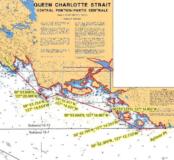
| Browning Islands to Raynor Group | Browning Islands to Raynor Group | Those waters of Subarea 12-13 that lie inside a line that: begins at 50°52.347'N 127°10.829'W Aylmer Point then to 50°52.300'N 127°12.733'W Gillot Rock then to 50°52.790'N 127°14.253'W Raynor Group then following the northeasterly shoreline to 50°53.123'N 127°14.802'W Raynor Group then to 50°53.094'N 127°14.967'W Brandon Rock then to 50°53.917'N 127°18.827'W Shell Islet then to 50°53.734'N 127°19.654'W Browning Islands then following the northeasterly shoreline to 50°53.908'N 127°20.085'W Browning Islands then to 50°55.017'N 127°21.939'W Stuart Point then easterly following the shoreline to the beginning point. |
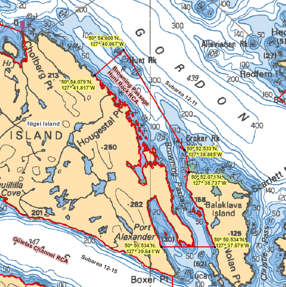
| Browning Passage | Browning Passage | Those waters of Subarea 12-11 that lie inside a line that:begins at 50°54.079'N 127°41.817'W Nigei Island then to 50°54.600'N 127°40.867'W in water then to 50°52.533'N 127°38.885'W Cardigan Rocks then to 50°52.071'N 127°38.737'W Raglan Point then to 50°50.534'N 127°37.879'W Balaklava Island then to 50°50.534'N 127°39.641'W Nigei Island then following the shoreline in a northwesterly direction to the beginning point. |
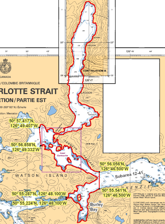
| Burley Bay - Nepah Lagoon | Burley Bay - Nepah Lagoon | Those waters of Subarea 12-41 that lie inside a line that: begins at 50°56.056'N 126°46.500'W shoreline then to 50°55.541'N 126°46.500'W shoreline then westerly following the shoreline to 50°55.224'N 126°48.100'W Hopetown Passage then to 50°55.287'N 126°48.100'W Watson Island then following the easterly shoreline of Watson Island to 50°56.858'N 126°49.332'W shoreline then to 50°57.417'N 126°49.407'W shoreline then following the shoreline around Nepah Lagoon to the beginning point. |
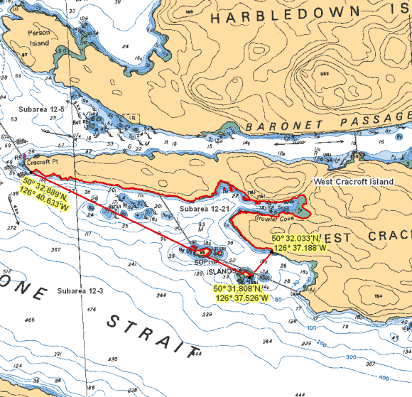
| Cracroft Point South - Sophia Islands | Cracroft Point South - Sophia Islands | Those waters of Subareas 12-3 and 12-21 that lie inside a line that: begins at 50°32.033'N 126°37.188'W south of Growler Cove then to 50°31.808'N 126°37.526'W Sophia Islands then to 50°32.889'N 126°40.633'W Cracroft Point then easterly following the shoreline to the beginning point. |
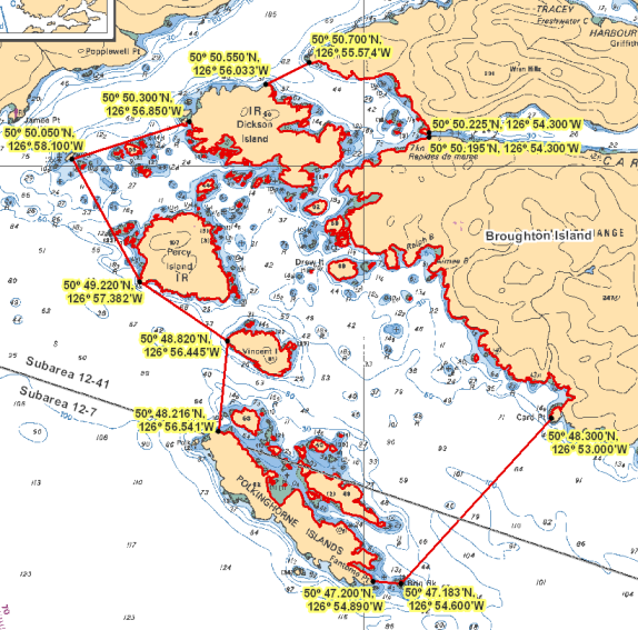
| Dickson - Polkinghorne Islands | Dickson - Polkinghorne Islands | Those waters of Subareas 12-7 and 12-41 that lie inside a line that begins at 50°50.050'N 126°58.100'W Ommaney Islet then to 50°50.300'N 126°56.850'W Dickson Island then following the northerly shoreline of Dickson Island to 50°50.550'N 126°56.033'W Dickson Island then to 50°50.700'N 126°55.574'W Bourmaster Point then southerly following the shoreline to 50°50.225'N 126°54.300'W Tidal Rapids then to 50°50.195'N 126°54.300'W Tidal Rapids then southerly following the shoreline to 50°48.300'N 126°53.000'W Card Point then to 50°47.183'N 126°54.600'W Brig Rock then to 50°47.200'N 126°54.890'W Fantome Point then following the northeasterly shoreline of Polkinghorne Islands to 50°48.216'N 126°56.541'W Polkinghorne Islands then to 50°48.820'N 126°56.445'W Vincent Island then to 50°49.220'N 126°57.382'W Percy Island then to the beginning point. |
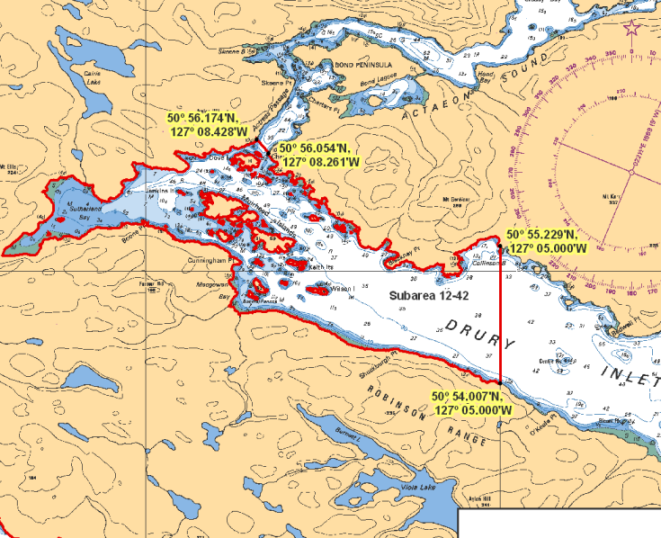
| Drury Inlet - Muirhead Islands | Drury Inlet - Muirhead Islands | Those waters of Subarea 12-42 that lie inside a line that: begins at 50°56.174'N 127°08.428'W shoreline then to 50°56.054'N 127°08.261'W Charlotte Point then easterly following the shoreline to 50°55.229'N 127°05.000'W Collinson Bay then to 50°54.007'N 127°05.000'W shoreline then following the shoreline easterly around Macgowan Bay, and Sutherland Bay to the beginning point. |
| Eden - Bonwick - Midsummer - Swanson Islands | Eden - Bonwick - Midsummer - Swanson Islands | Those waters of Subareas 12-6, 12-7, 12-26 and 12-39 that lie inside a line that: begins at 50°45.000'N 126°45.000'W in water then to 50°45.510'N 126°42.831'W Duff Point then southerly following the shoreline of Eden Island to 50°44.402'N 126°41.178'W Eden Island then to 50°43.613'N 126°41.170'W Crib Island then to 50°42.933'N 126°41.656'W Hudson Island then to 50°42.095'N 126°41.386'W unnamed islet then to 50°42.236'N 126°40.661'W west of Betty Cove then southerly following the shoreline of Bonwick Island to 50°41.135'N 126°40.152'W west of Success Point then to 50º 40.756'N 126º 41.353'W Sedge Island then following the northerly shoreline of Sedge Island to 50º 40.667'N 126º 41.568'W Sedge Island then to 50°40.000'N 126°41.600'W Canoe Islets then to 50°39.667'N 126°40.674'W Wolf Island then following the southerly shoreline of Wolf Island to 50°39.549'N 126°40.292'W Wolf Island then to 50°39.700'N 126°37.900'W Morning Islets then to 50°39.600'N 126°37.100'W Gilford Island then to 50°37.867'N 126°34.350'W Warr Bluff then following the westerly shoreline of Village Island to 50°36.715'N 126°33.863'W Village Island then to 50°36.386'N 126°34.628'W Hail Islets then to 50°36.245'N 126°36.275'W Alder Island then to 50°35.331'N 126°36.337'W Harbledown Island then westerly following the shoreline of Harbledown Island to 50°35.555'N 126°40.206'W Whitebeach Passage then to 50°35.737'N 126°40.202'W Sarah Islets then to 50°36.170'N 126°41.222'W Stoker Point then northerly and westerly following the shoreline of Swanson Island to 50°37.691'N 126°43.572'W Swanson Island then to 50°38.075'N 126°43.339'W Wedge Island Light then following the easterly shoreline of Wedge Island to 50°38.310'N 126°43.273'W Wedge Island then to 50°40.700'N 126°42.100'W Sedge Islands then to 50°43.200'N 126°43.467'W near Kate Islet then to 50°43.500'N 126°43.100'W near Crib Island then to 50°43.500'N 126°45.000'W in water then to the beginning point. |
| Goletas Channel | Goletas Channel | Those waters of Subarea 12-15 that lie easterly of a line: From 50°52.823'N 127°50.639'W Nigei Island To 50°51.200'N 127°51.500'W Vancouver Island. |
| Greenway Sound | Greenway Sound | Those waters of Subarea 12-40 that lie inside of a line that: begins at 50°51.755'N 126°44.036'W Cardale Head then to 50°51.587'N 126°42.370'W Walker Point then around Greenway Sound to 50°50.247'N 126°48.870'W shoreline then true north to 50°50.325'N 126°48.870'W Broughton Point then following the southerly shoreline of North Broughton Island to the beginning point. |
| Gwaxdlala/Nalaxdlala (Lull/Hoeya) | Gwaxdlala/Nalaxdlala (Lull/Hoeya) | That portion of Subarea 12-27 that lies inside a line that begins at 50°41.336' N, 126°02.560' W then easterly following the shoreline to 50°41.119' N, 125°57.484' W then southerly in a straight line to 50°39.979' N, 125°57.488' W then westerly following the shoreline to 50°39.667' N, 126°02.558' W then northerly in a straight line to the beginning point. |
| Haddington Passage | Haddington Passage | Those waters of Subarea 12-18 and 12-19 that lie inside a line that: begins at 50°36.155'N 127°02.297'W Neill Ledge Buoy then to 50°36.600'N 127°00.400'W Haddington Reefs then to 50°34.969'N 127°01.411'W Broad Point Light . |
| Hardy Bay - Five Fathom Rock | In Hardy Bay, those waters of Subarea 12-16 that lie within 150 metres of the Pinnacle located at approximately 50°44.600' north latitude and 127°29.200' west longitude as shown on Chart No. 3548 (published by the Canadian Hydrographic Service of Canada) and known locally as Five Fathom Rock. | |
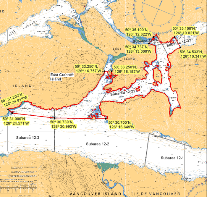
| Havannah Channel | Havannah Channel | Those waters of Subareas 12-2, 12-3, 12-22, 12-23 and 12-26 that lie inside a line that: begins at 50°33.250'N 126°16.757'W Mist Bluff then through the Mist Islets to 50°33.250'N 126°16.152'W shoreline then following the southerly shoreline of East Cracroft Island to 50°34.737'N 126°13.000'W west of Root Point then to 50°35.100'N 126°12.622'W Hadley Bay then easterly following the shoreline to 50°35.100'N 126°10.821'W shoreline then through Warren Island to 50°34.533'N 126°10.347'W shoreline then southerly and westerly following the shoreline to 50°30.700'N 126°16.649'W shoreline then through the Broken Islands to 50°30.739'N 126°20.993'W Escape Reef then to 50°31.000'N 126°24.571'W Bush Islets then to 50°31.200'N 126°24.915'W shoreline then following the southeasterly shoreline of West Cracroft Island to the beginning point. |
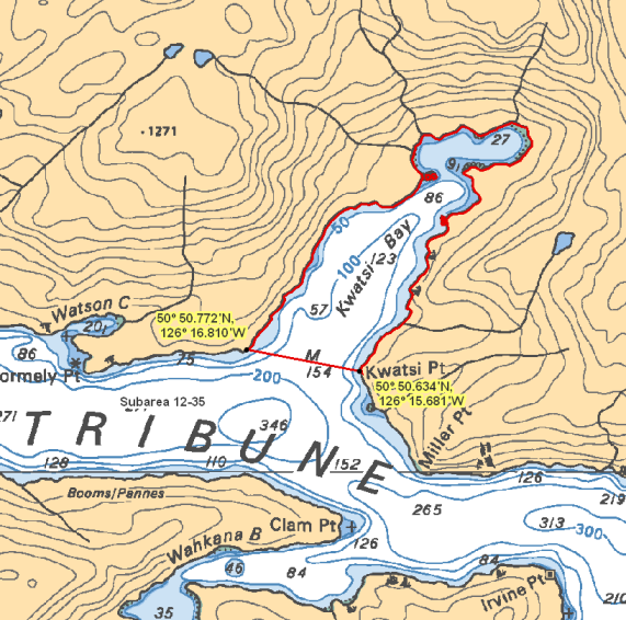
| Kwatsi Bay | Kwatsi Bay | Those waters of Subarea 12-35 that lie northerly of a line: From 50°50.772'N 126°16.810'W shoreline To 50°50.634'N 126°15.681'W Kwatsi Point. |
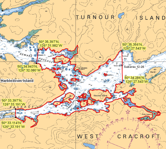
| Lower Clio Channel | Lower Clio Channel | Those waters of Subarea 12-26 that lie inside a line that: begins at 50°35.356'N 126°27.543'W Turnour Bay then to 50°34.286'N 126°27.543'W West Cracroft Island then westerly following the shoreline of West Cracroft Island to 50°33.114'N 126°33.191'W West Cracroft Island then to 50°33.397'N 126°33.191'W Harbledown Island then following the easterly shoreline of Harbledown Island to 50°34.943'N 126°32.080'W Harbledown Island then to 50°35.397'N 126°31.982'W Turnour Point. |
| Mackenzie - Nimmo | Mackenzie - Nimmo | Those waters of Subarea 12-41 that lie inside a line that: begins at 50°56.363'N 126°41.100'W shoreline then to 50°56.261'N 126°41.100'W shoreline then southerly following the shoreline to 50°56.045'N 126°41.100'W shoreline then to 50°55.726'N 126°41.100'W shoreline then westerly following the shoreline to 50°55.737'N 126°44.068'W shoreline then through Turner Island to 50°56.360'N 126°44.068'W shoreline then following the shoreline around Stirling Point, Nimmo Point and Nimmo Bay to the beginning point. |
| Nowell Channel | Nowell Channel | Those waters of Subarea 12-39 that lie inside a line that begins at 50°46.083'N 126°44.505'W North of Gordon Point then to 50°46.058'N 126°44.774'W unnamed island then following the northerly shoreline to 50°46.016'N 126°45.015'W unnamed island then to 50°46.010'N 126°45.048'W unnamed island then following the northerly shoreline to 50°45.782'N 126°45.471'W unnamed island then to 50°45.000'N 126°47.200'W in water then to 50°46.973'N 126°50.891'W Gawler Point then easterly following the shoreline around Booker Lagoon to the beginning point. |
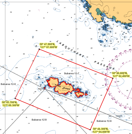
| Numas Islands | Numas Islands | Those waters of Subareas 12-6 to 12-9 that lie inside a line that: begins at 50°47.900' N 127°07.600' W in water then to 50°46.600' N 127°02.400' W in water then to 50°44.300' N 127°04.000' W in water then to 50°45.700' N 127°09.300' W in water then to the beginning point. |
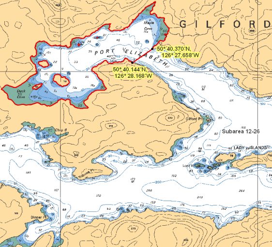
| Port Elizabeth | Port Elizabeth | Those waters of Subarea 12-26 that lie westerly of a line: From 50°40.370'N 126°27.658'W east of Maple Cove To 50°40.144'N 126°28.168'W Gilford Island. |
| Salmon Channel | Salmon Channel | Those waters of Subareas 12-6 and 12-7 that lie inside a line that:begins at 50°42.500'N 126°52.300'W near Foster Rock then to 50°44.200'N 126°48.900'W near Holford Rocks then to 50°44.100'N 126°48.250'W near Holford Islets then to 50°41.325'N 126°48.504'W near Penfold Islet then to 50°41.800'N 126°50.900'W near Twin Islets then to the beginning point. |
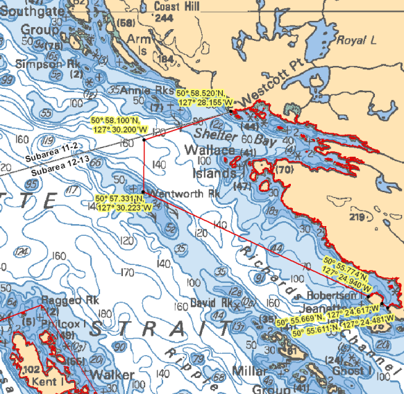
| Shelter Bay | Shelter Bay | Those waters of Subarea 12-13 that lie inside a line that begins at 50°55.611'N 127°24.481'W shoreline then to 50°55.669'N 127°24.617'W Robertson Island then following the northerly shoreline of Robertson Island to 50°55.774'N 127°24.940'W Robertson Island then to 50°57.331'N 127°30.223'W Wentworth Rock then to 50°58.100'N 127°30.200'W in water then to 50°58.520'N 127°28.155'W Westcott Point then southerly following the shoreline to the beginning point. |
| Susquash | Susquash | Those waters of Subareas 12-8 and 12-17 that lie inside a line that: begins at 50°39.536'N 127°16.947'W False Head then to 50°39.900'N 127°16.000'W in water then to 50°37.800'N 127°11.800'W in water then to 50°37.300'N 127°12.400'W Vancouver Island then northwesterly following the Vancouver Island shoreline to the beginning point. |
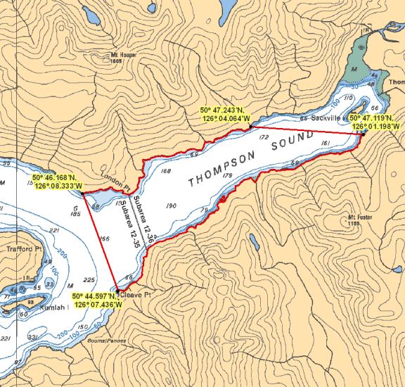
| Thompson Sound | Thompson Sound | Those waters of Subareas 12-35 and 12-36 that lie inside a line that: begins at 50°47.243'N 126°04.064'W shoreline then to 50°47.119'N 126°01.198'W shoreline then westerly following the shoreline of Thompson Sound to 50°44.597'N 126°07.436'W Cleave Point then to 50°46.168'N 126°08.333'W east of London Point then easterly following the shoreline to the beginning point. |
| Upper Call Inlet | Upper Call Inlet | Those waters of Subarea 12-23 that lie easterly of a line that: begins at 50°35.874'N 126°07.855'W shoreline then to 50°35.581'N 126°07.567'W shoreline. |
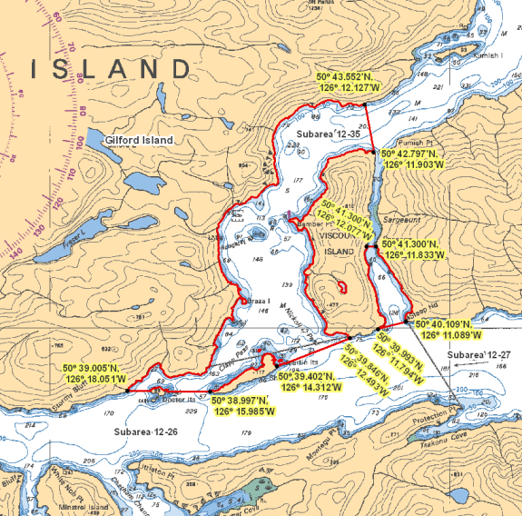
| Viscount Island | Viscount Island | Those waters of Subareas 12-26 and 12-35 that lie inside a line that: begins at 50°43.552'N 126°12.127'W shoreline then to 50°42.797'N 126°11.903'W Viscount Island then southerly following the Viscount Island shoreline to 50°41.300'N 126°12.077'W Sargeaunt Passage then to 50°41.300'N 126°11.833'W Sargeaunt Passage then southerly following the shoreline to 50°40.109'N 126°11.089'W Steep Head then to 50°39.993'N 126°11.794'W Viscount Island then easterly following the shoreline of Viscount Island to 50°39.846'N 126°12.493'W Viscount Island then to 50°39.402'N 126°14.312'W Shewell Island then following the northerly shoreline of Shewell Island to 50°38.997'N 126°15.985'W Shewell Island then through the Doctor Islets to 50°39.005'N 126°18.051'W Gilford Island then northerly following the shoreline to the beginning point. |
| Wakeman Sound | Wakeman Sound | Those waters of Subarea 12-48 that lie northerly of the parallel passing through 50°59.800' north latitude. |
| West Cracroft Island | West Cracroft Island | Those waters of Subarea 12-3 that lie inside a line that: begins at 50°31.203'N 126°31.213'W shoreline then to 50°30.700'N 126°31.200'W in water then to 50°30.800'N 126°33.700'W in water then to 50°31.500'N 126°33.556'W east of Boat Bay then easterly following the shoreline to the beginning point. |
| Weynton Passage | Weynton Passage | Those waters of Subareas 12-3, 12-4 and 12-18 that lie inside a line that begins at 50°37.122'N 126°49.800'W Donegal Head then to 50°35.200'N 126°48.324'W Ksuiladas Island then to 50°34.294'N 126°47.250'W Hanson Island then follow the westerly shore of Hanson Island to 50°33.867'N 126°46.533'W Hanson Island then to 50°34.467'N 126°51.833'W Pearse Islands then following the northerly shore of Pearce Island to 50°35.033'N 126°53.133'W Pearse Islands then to the beginning point. |
.png)
Last updated: 2025-05-06
- Date modified: