
BC tidal area 14 - Comox, Parksville, Denman and Hornby Islands: Recreational fishing limits, openings and closures
There will be a SHELLI update on Sunday, July 5, 2026, and possibly during the morning of Monday, July 6, 2026. The SHELLI service will not be fully available during that time. We apologize for the inconvenience.
Licence holders must follow fishing regulations unless otherwise specified in the Conditions of Licence.
How to follow the rules
- Make sure you have a current BC Tidal Waters sport fishing licence with you at all times. Are you using the FishingBC App for electronic licensing and catch recording? Learn more.
- Check the Area map. You need to know the location (subarea) where you plan to fish.
- Check the species regulations tables for fishing opportunities and basic regulations.
- Check the restrictions tables for special exceptions and more detailed regulations. Make sure you know the:
- Daily limit: The maximum number of a given fish species that a person is allowed to keep in one day.
- Possession limit: The maximum number of fish you can have in your possession at any given time, except for what is at your ordinary residence. The possession limit for most species is double the daily limit.
- Annual limit: The total amount of fish of a certain species that may be caught and retained during the course of a fishing year which starts on April 1 and ends the following March 31. Check "Restrictions" under each section for annual limits by species.
- Get to know the locations of protected areas. Permanent fishing restrictions are in effect in these areas to protect fish and fish habitat.
- Unless otherwise specified, fishing opportunities and closures end at 23:59 hrs on the close-date shown.
Related links
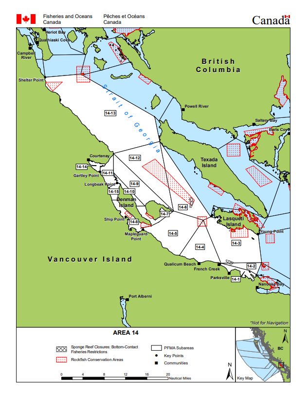
Area map
Area maps
This map is for information only and should not be used for fishing, navigation or other purposes.
For a written description of Areas please see the Pacific Fishery Management Area Regulations 2007.
Area 14: Download a printable PDF version of this map.

Salmon
Salmon
- You must have a valid a salmon conservation stamp on your BC Tidal Waters sport fishing licence if you plan to retain salmon.
- You must immediately and permanently record all retained chinook salmon on your paper licence, your NRLS catch log or your NRLS-linked FishingBC app catch log.
- Learn more about fishing for salmon
Maps
- Management measures to protect Southern Resident killer whales
- Area 14 - Comox, Parksville, Denman and Hornby Islands: coho salmon openings and other management measures
Species regulations
Always check for restrictions.
| Species | Areas | Min size | Gear | Daily Limits | Status |
|---|---|---|---|---|---|
| Chinook salmon (hatchery and wild combined) | 14 | 62cm | barbless hook and line | 0 | Non Retention |
| Chum salmon | 14 | 30cm | barbless hook and line | 2 | Open |
| Coho salmon (hatchery and wild combined) | 14 | 30cm | barbless hook and line | 2 Combined Total * Consisting of no more than:
|
Open |
| Pink salmon | 14 | 30cm | barbless hook and line | 4 | Open |
| Sockeye salmon | 14 | 30cm | barbless hook and line | 0 | Non Retention |
Last updated: 2026-06-09
Restrictions
Always check for protected areas.
| Species | Areas | Restriction type | Restriction details |
|---|---|---|---|
| Finfish | Comox Harbour | Closed | any gear or method (May 1 to Aug 31) |
| Southeasterly Shoreline of Hornby Island (2) | Closed | spear fishing while diving (year round ) | |
| Salmon | Coastwide | Daily Limit Pieces | 4 - The daily limit for all species of Pacific salmon from tidal and fresh waters combined is four. Individual species limits also apply. |
| 14 | Gear Restriction | You are not allowed to harvest using the following gears and methods:
|
|
| Coastwide | Reminder | When Open, the Possession Limit for salmon is twice the Daily Limit. | |
| Coastwide | Reminder | Hatchery (marked) salmon - Chinook and coho salmon with a healed scar in place of the adipose fin. | |
| Chinook salmon (hatchery and wild combined) | Coastwide | Annual Limit Pieces | 10 - The coastwide total annual limit for chinook salmon is 10 from all tidal waters that are open to chinook retention. |
| Coastwide | Reminder | Keeping your chinook salmon? You must permanently record all retained chinook salmon (head-on length) on your Tidal Waters Sport Fishing Licence. The licence holder may alternatively record retained catch immediately in an electronic licence held in an approved third-party application linked to their National Recreational Licensing System (NRLS) account, or if mobile internet access is immediately available, directly in their NRLS account. The licence holder shall ensure that all mandatory catch records for the current licence year are produced, either on the licence (paper or electronic), or from the licence holder's NRLS account at the time of inspection. |
Last updated: 2026-06-09
Area descriptions
| Area | Map | Area description |
|---|---|---|
| Coastwide | ||
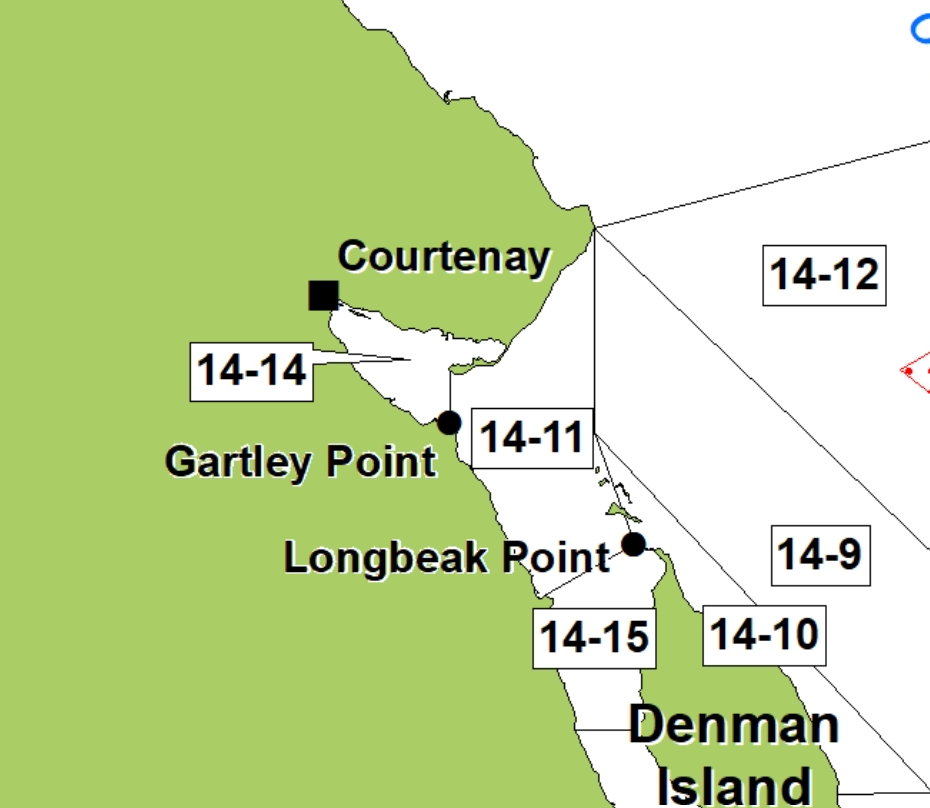
| Comox Harbour | In Subarea 14-14, Courtenay River Mouth - the waters of Comox Harbour inside a line from a fishing boundary sign near Trent River to a light at the tip of Goose Spit, except the shallow shore line defined as the waters inside and shoreward of the 2 m depth contour measured below the chart datum (0 tide). You may fish from the shoreline but not for Chinook Salmon. | |
| Southeasterly Shoreline of Hornby Island (2) | Southeasterly Shoreline of Hornby Island (2) | Those portions of Subareas 14-5, 14-6, 14-7, 14-9, and 14-12: shoreward of a line drawn from Shingle Spit at 49°30.773' N, 124° 42.502' W southwesterly to a point in water at 49°30.674' N, 124° 42.887' W, thence southeasterly to a point on the Subarea 14-7 boundary line at 49° 28.820' N, 124° 39.541' W, thence northeasterly following the Subarea 14-7 boundary line to a point on at 49°29.030' N, 124°38.867' W, thence northeasterly to a point in water southeast of Tribune Bay at 49°30.400' N, 124°36.974' W, thence northwesterly to a point in water in Tribune Bay at 49°31.032' N, 124°38.055'W, thence northeasterly to a point in Tribune Bay at 49°31.219' N, 124° 37.776' W, thence southeasterly to a point in water at 49°30.730' N, 124°36.594' W, thence easterly to a point in water east of Flora Islet at 49°30.947' N, 124° 34.075' W, thence northwesterly to a point in water north of Cape Gurney at 49°32.189' N, 124°36.139' W, and thence southerly to a point on land on Cape Gurney at 49°31.748' N, 124°36.139' W. |
.jpeg)
Last updated: 2026-06-09
Other finfish
Finfish other than salmon
- You must immediately and permanently record the following retained catch on your paper licence, your NRLS catch log or your NRLS-linked FishingBC app catch log.
- halibut
- lingcod caught in Areas 12 to 19 (excluding Subarea 12-14) and Subareas 20-5 to 20-7 and 29-5
- Check the Restrictions for the current possession limit for Pacific halibut
- Learn more about fishing for finfish
Species regulations
Always check for restrictions.
| Species | Areas | Min size | Gear | Daily Limits | Status |
|---|---|---|---|---|---|
| Codfish | 14 | angling, spear fishing while diving | 8 | Open | |
| Eulachon | 14 | 0kg | Closed | ||
| Finfish - all other species | 14 | angling, dip net, herring jig, herring rake, spear fishing while diving | 20 | Open | |
| Greenling | 14 | angling, spear fishing while diving | 3 | Open | |
| Halibut | 14 | angling, spear fishing while diving | 1 | Open | |
| Herring | 14 | cast net, dip net, herring jig, herring rake | 20kg | Open | |
| Lingcod | 14 | 65cm | angling, spear fishing while diving | 1 | Open |
| Mackerel | 14 | angling, dip net, herring jig, herring rake, spear fishing while diving | 100 | Open | |
| Northern Anchovy | 14 | cast net, dip net, herring jig, herring rake | 20kg | Open | |
| Pacific sand lance | 14 | cast net, dip net, herring jig, herring rake | 5kg | Open | |
| Pacific sardine | 14 | angling, dip net, herring jig, herring rake, spear fishing while diving | 100 | Open | |
| Rockfish - Yelloweye | 14 | angling, spear fishing while diving | 0 | Non Retention | |
| Rockfish - all species except Yelloweye | 14 | angling, spear fishing while diving | 1 | Open | |
| Sablefish | 14 | angling | 4 | Open | |
| Sculpin | 14 | angling | 8 | Open | |
| Shark - Basking | 14 | 0 | Closed | ||
| Shark - Blue | 14 | 0 | Closed | ||
| Shark - Brown Cat | 14 | 0 | Closed | ||
| Shark - Great White | 14 | 0 | Closed | ||
| Shark - Salmon | 14 | angling, spear fishing while diving | 1 | Open | |
| Shark - Sixgill | 14 | 0 | Closed | ||
| Shark - Tope | 14 | 0 | Closed | ||
| Shark - all other species | 14 | 0 | Closed | ||
| Skate | 14 | angling | 1 | Open | |
| Smelt | 14 | dip net, gill net | 20kg | Open | |
| Sole or Flounder | 14 | angling, spear fishing while diving | 8 | Open | |
| Spiny Dogfish | 14 | angling, spear fishing while diving | 0 | Non Retention | |
| Surfperch | 14 | angling | 8 | Open | |
| Tuna - Albacore | 14 | angling, spear fishing while diving | 20 | Open | |
| Tuna - Pacific bluefin | 14 | angling, spear fishing while diving | 20 | Open | |
| Tuna - all other species | 14 | angling, spear fishing while diving | 20 | Open | |
| White Sturgeon | 14 | angling | 0 | Non Retention | |
| Wolf Eel | 14 | angling | 0 | Non Retention |
| Species | Areas | Min size | Gear | Daily Limits | Status |
|---|---|---|---|---|---|
| Trout (hatchery and wild combined) | 14 | 30cm | angling | 2 Combined Total * Consisting of no more than:
|
Open |
Last updated: 2026-06-10
Restrictions
Always check for protected areas.
| Species | Areas | Restriction type | Restriction details |
|---|---|---|---|
| Finfish | Comox Harbour | Closed | any gear or method (May 1 to Aug 31) |
| Southeasterly Shoreline of Hornby Island (2) | Closed | spear fishing while diving (year round ) | |
| Finfish - all other species | Southeasterly Shoreline of Hornby Island (2) | Closed | spear fishing while diving (year round ) |
| Other Finfish | Coastwide | Reminder | When Open, the Possession Limit for finfish other than salmon is twice the Daily Limit – except for Halibut (see Restrictions section). |
| Herring | Coastwide | Reminder | Harvesting of herring roe from marine plants or plants placed in the water for the purpose of harvesting herring roe is prohibited. |
| Eulachon | Coastwide | Closed | Due to conservation concerns the harvesting of eulachon is prohibited. |
| Codfish | Southeasterly Shoreline of Hornby Island (2) | Closed | spear fishing while diving (year round ) |
| Coastwide | Reminder | Species includes - Pacific cod, Pacific tomcod, pollock and hake but does not include lingcod. | |
| Greenling | Southeasterly Shoreline of Hornby Island (2) | Closed | spear fishing while diving (year round ) |
| Halibut | Southeasterly Shoreline of Hornby Island (2) | Closed | spear fishing while diving (year round ) |
| Coastwide | Reminder | As a Condition of Licence, no person shall catch and retain more than ten (10) Halibut in the aggregate from April 1, 2026 to March 31, 2027. No person shall retain a Halibut greater than 112 cm head-on length (85 cm pectoral length (head-off)). The possession limit is equal to the daily limit. Head-off measurements are made from the base of the pectoral fin at its most forward point to the extreme end of the middle of the tail. | |
| Coastwide | Reminder | You must permanently record all retained Halibut (head-on length) on your Tidal Waters Sport Fishing Licence. The licence holder may alternatively record retained catch immediately in an electronic licence held in an approved third-party application linked to their National Recreational Licensing System (NRLS) account, or if mobile internet access is immediately available, directly in their NRLS account. The licence holder shall ensure that all mandatory catch records for the current licence year are produced, either on the licence (paper or electronic), or from the licence holder's NRLS account at the time of inspection. | |
| Lingcod | Southeasterly Shoreline of Hornby Island (2) | Closed | spear fishing while diving (year round ) |
| 14 | Annual Limit Pieces | 10 - The total annual limit for lingcod is 10 from the following tidal areas when they are open to lingcod retention - Areas 12 to 19 (excluding Subarea 12-14), Subareas 20-5 to 20-7, and 29-5. | |
| 14 | Reminder | Areas 12 to 19 (excluding Subarea 12-14), Subareas 20-5 to 20-7, and 29-5 - You must permanently record all retained Lingcod on your Tidal Waters Sport Fishing Licence. The licence holder may alternatively record retained catch immediately in an electronic licence held in an approved third-party application linked to their National Recreational Licensing System (NRLS) account, or if mobile internet access is immediately available, directly in their NRLS account. The licence holder shall ensure that all mandatory catch records for the current licence year are produced, either on the licence (paper or electronic), or from the licence holder's NRLS account at the time of inspection. | |
| Coastwide | Reminder | The pectoral length (head -off) requirement for Lingcod is 53 cm. Pectoral length (head-off) measurements are made from the base of the pectoral fin at its most forward point to the extreme end of the middle of the tail. | |
| Coastwide | Season Planning | For planning purposes only: For in-season requirements, please see current regulations/restrictions for specific areas, gear and individual species limits, and closures/exceptions. INSIDE WATERS - Generally open May 1 to September 30, for Areas 13 to 19 and Subareas 12-1 to 12-13, 12-15 to 12-48, 20-5 to 20-7 and 29-5. Closed year round - Area 28 and Subareas 29-1 to 29-4 and 29-6 to 29-17. OUTSIDE WATERS - Generally open April 1 to November 15, for Areas 1 to 10, 101 to 110, 130, 142, 11, 21 to 27, 111, 123 to 127, Subareas 12-14 and 20-1 to 20-4, and Area 121 (portion). | |
| Perch | Coastwide | Reminder | Includes kelp, shiner and pile perch, and all species of surf and sea perch. |
| Rockfish | Coastwide | Reminder | Anglers in vessels shall immediately return all rockfish that are not being retained to the water and to a similar depth from which they were caught by use of an inverted weighted barbless hook or other purpose-built descender device. |
| Coastwide | Season Planning | For planning purposes only: For in-season requirements, please see current regulations/restrictions for specific areas, gear and individual species limits, and closures/exceptions. INSIDE WATERS - Generally open May 1 to September 30, for Areas 13 to 19 and Subareas 12-1 to 12-13, 12-15 to 12-48, 20-5 to 20-7 and 29-5. Closed year round - Area 28 and Subareas 29-1 to 29-4 and 29-6 to 29-17. OUTSIDE WATERS - Generally Open April 1 to November 15, for Areas 1 to 10, 101 to 110, 130, 142, 11, 21 to 27, 111, 123 to 127, Subareas 12-14 and 20-1 to 20-4, and Area 121 (portion). | |
| Sculpin | Coastwide | Reminder | Cabezon is a species of sculpin; for daily and possession limits, please see the species regulations table above for sculpin. |
| Sole or Flounder | Southeasterly Shoreline of Hornby Island (2) | Closed | spear fishing while diving (year round ) |
| Trout (hatchery and wild combined) | Coastwide | Reminder | Note: (1) Trout - means Brook trout, Brown trout, Cutthroat trout, Dolly Varden, Lake trout, Rainbow trout, Steelhead, and includes Bull trout. (2) Steelhead - in waters where anadromous Rainbow trout are found, Steelhead means a Rainbow trout that is greater than 50cm in overall length. (3) Anadromous means migrating from the sea up rivers or streams to spawn. |
Last updated: 2026-06-10
Area descriptions
| Area | Map | Area description |
|---|---|---|
| Coastwide | ||
| Comox Harbour | In Subarea 14-14, Courtenay River Mouth - the waters of Comox Harbour inside a line from a fishing boundary sign near Trent River to a light at the tip of Goose Spit, except the shallow shore line defined as the waters inside and shoreward of the 2 m depth contour measured below the chart datum (0 tide). You may fish from the shoreline but not for Chinook Salmon. | |
| Southeasterly Shoreline of Hornby Island (2) | Southeasterly Shoreline of Hornby Island (2) | Those portions of Subareas 14-5, 14-6, 14-7, 14-9, and 14-12: shoreward of a line drawn from Shingle Spit at 49°30.773' N, 124° 42.502' W southwesterly to a point in water at 49°30.674' N, 124° 42.887' W, thence southeasterly to a point on the Subarea 14-7 boundary line at 49° 28.820' N, 124° 39.541' W, thence northeasterly following the Subarea 14-7 boundary line to a point on at 49°29.030' N, 124°38.867' W, thence northeasterly to a point in water southeast of Tribune Bay at 49°30.400' N, 124°36.974' W, thence northwesterly to a point in water in Tribune Bay at 49°31.032' N, 124°38.055'W, thence northeasterly to a point in Tribune Bay at 49°31.219' N, 124° 37.776' W, thence southeasterly to a point in water at 49°30.730' N, 124°36.594' W, thence easterly to a point in water east of Flora Islet at 49°30.947' N, 124° 34.075' W, thence northwesterly to a point in water north of Cape Gurney at 49°32.189' N, 124°36.139' W, and thence southerly to a point on land on Cape Gurney at 49°31.748' N, 124°36.139' W. |
Last updated: 2026-06-10
Bivalve shellfish and snails
Bivalve shellfish and snails
Eating contaminated shellfish can be life threatening. Closures change frequently throughout the year. It is illegal to harvest shellfish from closed or contaminated areas.
Bivalve shellfish have 2 hinged shells. Because they feed by filtering microscopic plankton from the water, changes in water quality can cause unsafe marine biotoxins, bacteria, or viruses to build up in their tissue.
Snails refers to all snails, whelks, tritons and periwinkles with the exception of Moon Snails. Snails and moon snails can accumulate toxins and pollutants. We recommend that they not be harvested from areas shown as closed in the table below.
Learn more about shellfish harvesting.
How to follow the rules
- Check for contamination in the subarea where you plan to harvest. You can also see this in a map format by using our our real-time bivalve shellfish safety harvesting map.
- If no contamination closures are in effect, check species regulations and additional harvest restrictions.
- You are not allowed to harvest within the boundaries of an aquaculture facility. See our interactive map for currently licensed bivalve aquaculture facility locations or, where available, refer to signs and markers on the beach.
- Littleneck, Manila and butter clams are subject to a minimum size limit. See below under restrictions for more information on clam size limits.
- Questions? Email us at DFO.PACCSSP-PCAMPAC.MPO@dfo-mpo.gc.ca.
Bivalve shellfish contamination closures
Planned bivalve shellfish harvesting closures
Look at the first column below to see which species are safe to harvest. If there is information in the second column, it is illegal and unsafe to harvest any bivalve species in those areas.
| Subarea | Marine biotoxin update (open bivalve species) | Sanitary contamination closures (closed to shellfish harvesting) |
|---|---|---|
| 14-1 | Geoduck;Clam - Horse;Clam - Littleneck;Clam - Manila;Mussels - all species combined;Oyster - Pacific | |
| 14-2 | Clam - Littleneck;Clam - Manila;Mussels - all species combined;Oyster - Pacific | |
| 14-3 | Geoduck;Clam - Horse;Mussels - all species combined | |
| 14-4 | Geoduck;Clam - Horse;Clam - Littleneck;Clam - Manila;Mussels - all species combined;Oyster - Pacific | |
| 14-5 | Geoduck;Clam - Horse;Clam - Littleneck;Clam - Manila;Mussels - all species combined;Oyster - Pacific;Scallop - other;Scallop - Pacific;Scallop - Pink;Scallop - Spiny | |
| 14-6 | Closed to All Bivalve Species | |
| 14-7 | Clam - Littleneck;Clam - Manila;Mussels - all species combined;Oyster - Pacific | |
| 14-8 | Clam - Littleneck;Clam - Manila;Clam - Varnish;Mussels - all species combined;Oyster - Pacific;Scallop - other;Scallop - Pacific;Scallop - Pink;Scallop - Spiny | |
| 14-9 | Clam - Littleneck;Clam - Manila;Mussels - all species combined;Oyster - Pacific | |
| 14-10 | Clam - Littleneck;Clam - Manila;Mussels - all species combined;Oyster - Pacific | |
| 14-11 | Clam - Butter;Clam - Littleneck;Clam - Manila;Mussels - all species combined;Oyster - Pacific | |
| 14-12 | Closed to All Bivalve Species | |
| 14-13 | Clam - Littleneck;Clam - Manila;Mussels - all species combined;Oyster - Pacific | |
| 14-14 | Clam - Littleneck;Clam - Manila;Mussels - all species combined;Oyster - Pacific | |
| 14-15 | Clam - Butter;Clam - Littleneck;Clam - Manila;Clam - Varnish;Mussels - all species combined;Oyster - Pacific;Scallop - other;Scallop - Pacific;Scallop - Pink;Scallop - Spiny |
Last updated: 2026-07-02
Species regulations
Always check for restrictions.
| Species | Areas | Gear | Daily Limits |
|---|---|---|---|
| Clam - Butter | 14 | hand digging, hand picking | 20 |
| Clam - Horse | 14 | hand digging, hand picking | 6 |
| Clam - Littleneck | 14 | hand digging | 60 |
| Clam - Manila | 14 | hand digging | 60 |
| Clam - Razor | 14 | hand digging | 12 |
| Clam - Softshell | 14 | hand digging | 25 |
| Clam - Varnish | 14 | hand digging | 60 |
| Clam - all species combined | 14 | hand digging, hand picking | 60 |
| Cockles | 14 | hand digging, hand picking | 25 |
| Geoduck | 14 | hand digging, hand picking | 3 |
| Mussel - Blue | 14 | hand picking | 75 |
| Mussel - California | 14 | hand picking | 25 |
| Mussels - all species combined | 14 | hand picking | 75 |
| Oyster - Olympia | 14 | 0 | |
| Oyster - all species except Olympia | 14 | hand picking | 12 |
| Scallop - Pink and Spiny | 14 | hand picking, hand picking while diving | 75 |
| Scallop - Purple-hinged rock | 14 | hand picking, hand picking while diving | 6 |
| Scallop - Weathervane | 14 | hand picking, hand picking while diving | 6 |
| Scallop - Weathervane and Purple-hinged rock combined | 14 | hand picking, hand picking while diving | 6 |
| Snail - Moon | 14 | hand picking | 2 |
| Snail - other | 14 | hand picking | 75 |
| Whelks | 14 | hand picking | 75 |
Last updated: 2026-06-09
Restrictions
Always check for protected areas.
| Species | Areas | Restriction type | Restriction details |
|---|---|---|---|
| Shellfish | Rathtrevor Provincial Park | Closed | any gear or method (year round ) |
| Southeasterly Shoreline of Hornby Island (2) | Closed | any gear or method (year round ) | |
| Bivalve Species | Coastwide | Reminder | When Open, the Possession Limit for bivalve shellfish is twice the Daily Limit. |
| Coastwide | Reminder | Because of the risk of contamination, you are not allowed to harvest bivalve shellfish (for any purpose) within: (1) 300 metres around industrial, municipal and sewage treatment plant outfall discharges (2) 125 metres around a marina, ferry wharf, floating living accommodation, or any finfish net pen (exceptions described as follows) (3) 25 meters around any floating living accommodation facility located within a shellfish aquaculture tenure where a zero-discharge and appropriate waste management plan is a condition of the Aquaculture Licence and is approved by the Regional Interdepartmental Committee (4) 0 meters of any finfish net pen within an aquaculture tenure where an Integrated Multi-Trophic Aquaculture Management Plan approved by the Regional Interdepartmental Committee is in operation. | |
| Coastwide | Reminder | Clams - No person shall retain a Manila Clam or Littleneck Clam smaller than 35 mm, nor a Butter Clam smaller than 55 mm. | |
| Coastwide | Reminder | Only aquaculture operators are allowed to harvest within the boundaries of licenced aquaculture facilities. Please be aware of the location of aquaculture facilities in the areas close to where you are intending to harvest. | |
| Clam - Butter | Mitlenatch Island | Closed | hand digging (year round ), hand picking (year round ) |
| Clam - Horse | Mitlenatch Island | Closed | hand digging (year round ), hand picking (year round ) |
| Clam - Littleneck | Mitlenatch Island | Closed | hand digging (year round ), hand picking (year round ) |
| Clam - Manila | Mitlenatch Island | Closed | hand digging (year round ), hand picking (year round ) |
| Clam - Razor | Mitlenatch Island | Closed | hand digging (year round ), hand picking (year round ) |
| Clam - Softshell | Mitlenatch Island | Closed | hand digging (year round ), hand picking (year round ) |
| Clam - Varnish | Mitlenatch Island | Closed | hand digging (year round ), hand picking (year round ) |
| Clam - all species combined | Mitlenatch Island | Closed | hand digging (year round ), hand picking (year round ) |
| Coastwide | Daily Limit Pieces | 60 - When open, all species aggregate daily limit combined Areas 1 to 27 is 60, except Pacific Rim National Park where the all-species aggregate limit is 24. | |
| 14 | Reminder | Clam harvesters are encouraged to fill in holes to reduce predation on exposed juvenile clams. | |
| 14 | Reminder | It is illegal to use any mechanical apparatus or dredge for harvesting clams. | |
| Cockles | Mitlenatch Island | Closed | hand digging (year round ), hand picking (year round ) |
| Geoduck | Mitlenatch Island | Closed | hand digging (year round ), hand picking (year round ) |
| Mussels - all species combined | 14 | Reminder | Combined daily limit for all mussel species is 75. |
| Oyster - Olympia | Mitlenatch Island | Closed | hand picking (year round ) |
| Oyster - all species except Olympia | Mitlenatch Island | Closed | hand picking (year round ) |
| 14 | Packaging and Transporting | Avoid transfer of green crab - Harvesters are encouraged to shuck oysters on the beach and leave the shells there, or return oyster shells to the beach from where you collected them whenever possible. In order to avoid the transfer of European green crab, please dispose of any oyster shell harvested from the west coast of Vancouver Island back to the beach from where it came or with your household garbage. Consult your local DFO Office. You will need permission to harvest oysters from marked oyster farms. | |
| Coastwide | Reminder | To avoid inadvertently harvesting Olympia oysters while you are harvesting Pacific oysters, do not harvest any oyster less than 5 cm in diameter. | |
| Snail - Moon | 14 | Reminder | Moon snails may be subject to PSP, check for closures. Consult your local DFO office for details. |
| Scallop - Purple-hinged rock | Southeasterly Shoreline of Hornby Island (2) | Closed | diving (year round ), hand picking while diving (year round ), spear fishing while diving (year round ) |
| Scallop - Pink and Spiny | Southeasterly Shoreline of Hornby Island (2) | Closed | diving (year round ), hand picking while diving (year round ), spear fishing while diving (year round ) |
| Scallop - Weathervane | Southeasterly Shoreline of Hornby Island (2) | Closed | diving (year round ), hand picking while diving (year round ), spear fishing while diving (year round ) |
Last updated: 2026-06-09
Area descriptions
| Closure | Map | Area description |
|---|---|---|
| 13.3 A portion of Discovery Passage to Kuhushan Point | 13.3.png | The intertidal foreshore of southern Discovery Passage, from the southern Campbell River Harbour limit, located at 49°59.69' north latitude and 125°13.71' west longitude, thence southeasterly to the spit located west of Kuhushan Point at 49°53.92' north latitude and 125°09.11' west longitude. [NAD83] |
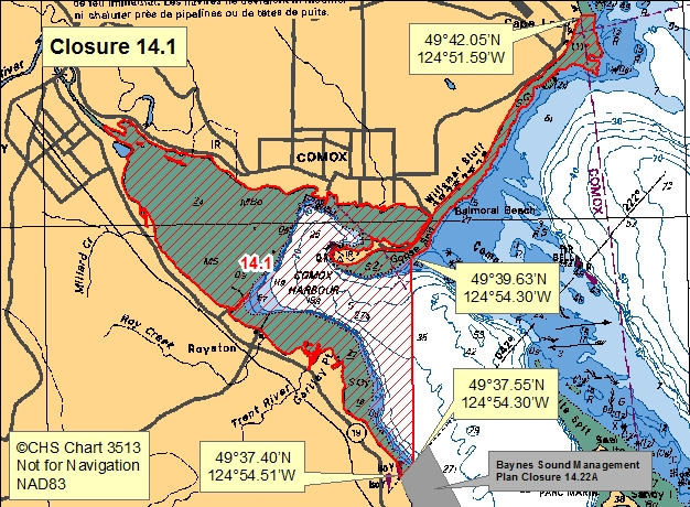
| 14.1 Comox Harbour | 14.1.png | The waters and intertidal foreshore of Comox Harbour lying inside a line drawn from the point on land at the range markers at 49°37.40' north latitude and 124°54.51' west longitude, south of Gartley Point, thence seaward northeasterly to a point in water at 49°37.55' north latitude and 124°54.30' west longitude, thence due north towards the road entrance gate to HMCS Quadra on Goose Spit to a point in water at 49°39.63' north latitude and 124°54.30' west longitude, thence extending northeasterly along the low water mark to the first prominent point of land at the south end of Cape Lazo at 49°42.05' north latitude and 124°51.59' west longitude. [NAD83] |
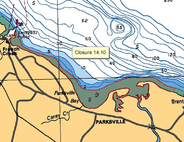
| 14.10 Parksville Bay, Englishman River to French Creek | 14.10.png | The waters and intertidal foreshore of the Englishman River and Parksville Bay to French Creek, starting at a point east of the Englishman River mouth at the Rathtrevor Provincial Park northwest boundary at 49°19.60' north latitude and 124°16.40' west longitude, thence westerly through Parksville Bay to the French Creek marina quick-flashing red beacon. [NAD83] |
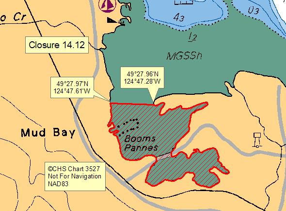
| 14.12 Mud Bay, Baynes Sound | 14.12.png | The waters and intertidal foreshore of Mud Bay lying inside of a line drawn from a point on land from the western shore of Mud Bay at 49°27.97' north latitude and 124°47.61' west longitude thence easterly to a point on the western end of the peninsula of land at 49°27.96' north latitude and 124°47.28' west longitude thence following the southern shoreline highwater mark back to the point of commencement. [NAD83] |
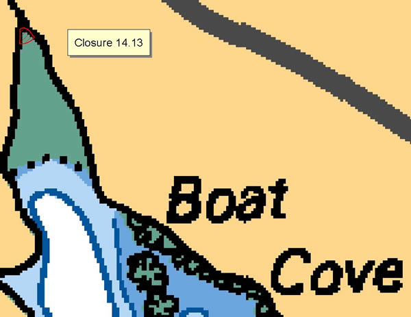
| 14.13 Boat Cove, Lasqueti Island | 14.13.png | The waters and intertidal foreshore which lie within a 50 metre radius of the mouth of the creek at the head of Boat Cove, Lasqueti Island. [NAD83] |
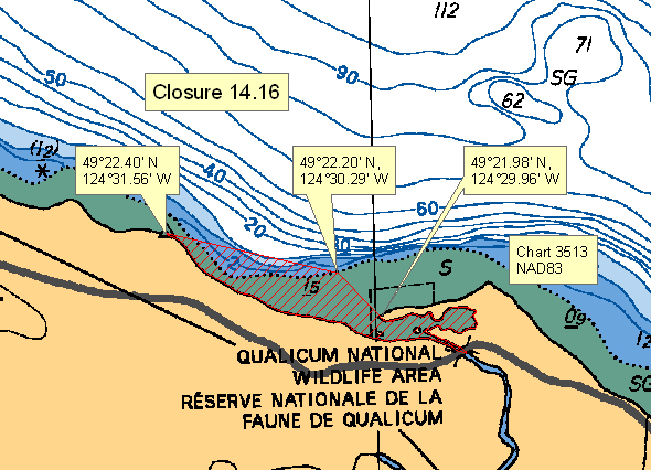
| 14.16 Mouth of Little Qualicum River | 14.16.png | The waters and intertidal foreshore at the mouth of the Little Qualicum River, starting at the tip of the spit at 49°21.98' north latitude and 124°29.96' west longitude thence northwesterly to the low water mark at 49°22.20' north latitude and 124°30.29' west longitude, thence westerly in a straight line to a point of land at 49°22.40' north latitude and 124°31.56' west longitude. [NAD83] |
| 14.17 False Bay, Lasqueti Island | 14.17.png | The waters and intertidal foreshore of the small bay northeast of Higgins Island in False Bay, Lasqueti Island, commencing from the point of land at 49°29.99' north latitude and 124°21.45' west longitude, thence southward to the southeast tip of the small island in the bay, thence eastward to the point of land at 49°29.90' north latitude and 124°21.57' west longitude. [NAD83] |
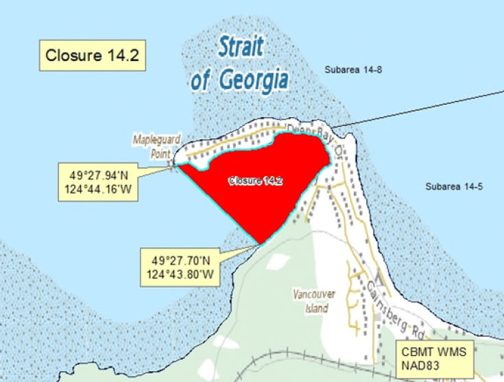
| 14.2 Deep Bay, Baynes Sound | 14.2.png | The waters and intertidal foreshore of Deep Bay Harbour at the southwest end of Baynes Sound lying inside a line drawn from the tip of Mapleguard Point at 49°27.94' north latitude and 124°44.16' west longitude southeasterly to a point on land at 49°27.70' north latitude and 124°43.80' west longitude. [NAD83] |
| 14.21 Kitty Coleman Beach to Little River | 14.21.png | The waters and intertidal foreshore from the boat ramp at Kitty Coleman Beach Provincial Park at 49°47.45' north latitude and 124°59.60' west longitude to the peninsula at the mouth of Little River at 49°44.55' north latitude and 124°55.35' west longitude. [NAD27] |
| 14.27 Comox | 14.27.png | Those portions of Subareas 14-12 and 14-13 inside a line drawn from a point in the water at 49°42.39' north latitude and 124°49.96' west longitude, thence northeasterly to a point in the water at 49°42.59' north latitude and 124°49.32' west longitude, thence southeasterly to a point in the water at 49°41.94' north latitude and 124°48.86' west longitude, thence southwesterly to a point in the water at 49°41.73' north latitude and 124°49.51' west longitude, thence northwesterly back to the point of commencement. [NAD83] |
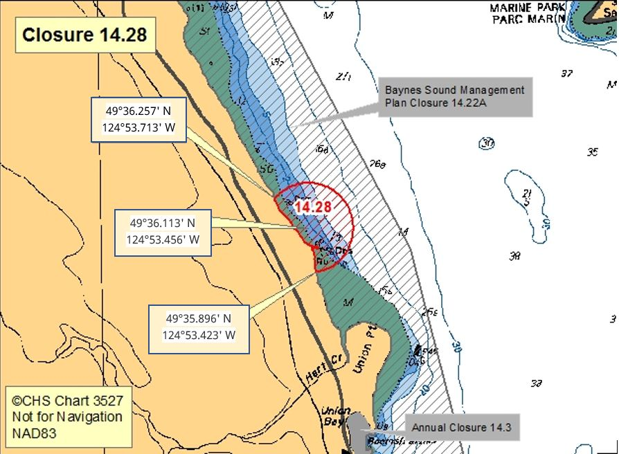
| 14.28 Union Bay, Northwest of Union Point | 14.28.png | The waters and intertidal foreshore within a 400 m radius of a point on land on the east shore of Vancouver Island at 49°36.113' north latitude and 124°53.456' west longitude, north of Union Point. The northwestern boundary is a point on land at 49°36.257' north latitude and 124°53.713' west longitude and the southeastern boundary is a point on land at 49°35.896' north latitude and 124°53.423' west longitude. [NAD 83] |
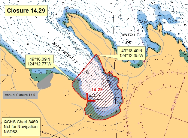
| 14.29 Northwest Bay | 14.29.png | The waters and intertidal foreshore of Northwest Bay lying south of a line drawn from a point of land on the west side of the entrance at 49º18.09' north latitude and 124º12.77' west longitude thence northeasterly to the east side of the entrance to a point of land at 49°18.40' north latitude and 124°12.35' west longitude. [NAD83] |
| 14.3 Union Bay, Baynes Sound | 14.3.png | The intertidal foreshore of Union Bay, Baynes Sound lying west of a line drawn from a point of land on the southern headland of Union Bay at 49°35.13' north latitude and 124°53.01' west longitude southerly to the foot of Tipton Road at 49°34.32' north latitude and 124°52.75' west longitude. [NAD83] |
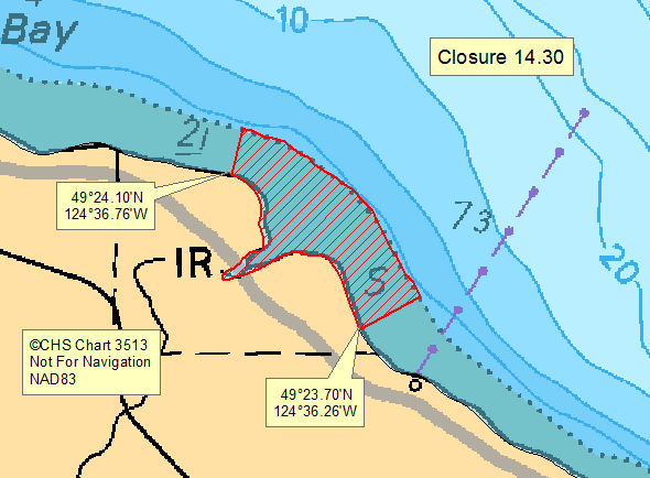
| 14.30 Qualicum River Estuary | 14.30.png | The intertidal foreshore of the Qualicum River Estuary from a point on land at 49°24.10' north latitude and 124°36.76' west longitude, thence southeasterly following the intertidal boundary to a point on land at 49°23.70' north latitude and 124°36.26' west longitude. [NAD83] |
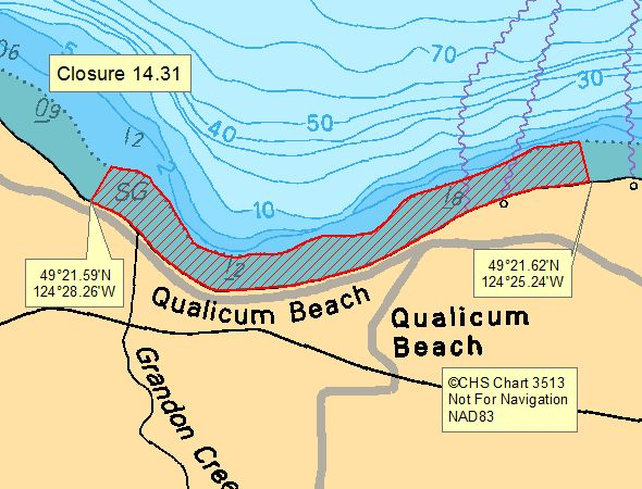
| 14.31 Qualicum Beach | 14.31.png | The intertidal foreshore of Qualicum Beach from a point on land at 49°21.59' north latitude and 124°28.26' west longitude 400 m northwest of the mouth of Grandon Creek following the intertidal boundary easterly to a point on land at 49°21.62' north latitude and 124°25.24' west longitude, 300 m east of the Hall Road Pump Station. [NAD83] |
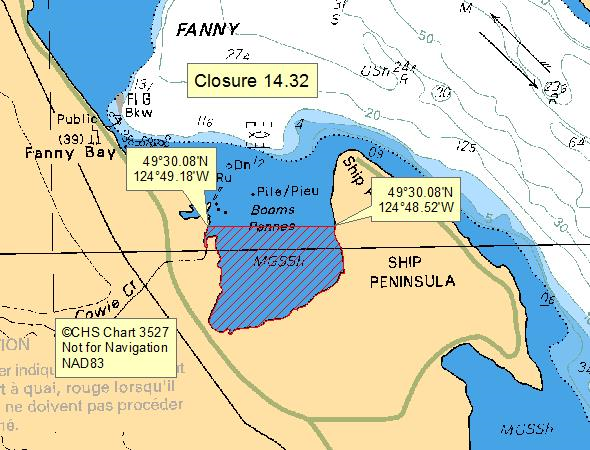
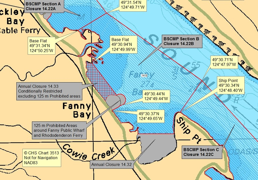
| 14.32 A portion of Fanny Bay, Baynes Sound | 14.32.png | The waters and intertidal foreshore of Fanny Bay south of a line drawn from a point on land within the Fanny Bay Conservation Area at 49°30.08' north latitude and 124°48.52' west longitude, southerly of Ship Point, thence due west to a point on land at 49°30.08' north latitude and 124°49.18' west longitude. [NAD83] |
| 14.33 A portion of Fanny Bay, Baynes Sound | 14.33.png | The waters and intertidal foreshore of Fanny Bay lying inside a line drawn from a point on land, 125 m south of the Fanny Bay Public Wharf at 49°30.37' north latitude and 124°49.65' west longitude, thence seaward northeasterly to a point in water at 49°30.44' north latitude and 124°49.44' west longitude, thence northwesterly to a point on land at 49°30.94' north latitude and 124°49.99' west longitude excluding the 125 m Prohibited area around the Fanny Bay Public wharf and Rhododendeeron Ferry. [NAD 83] |
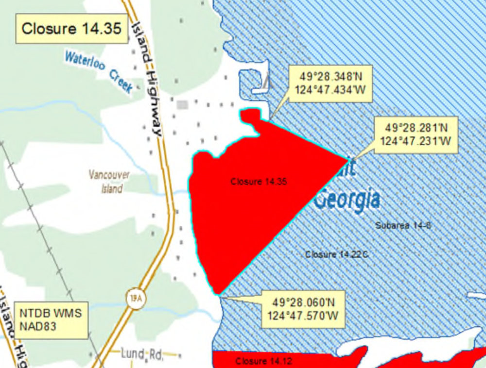
| 14.35 Mud Bay, Waterloo Creek | 14.35.png | The waters and intertidal foreshore of Mud Bay, Baynes Sound lying inside a line drawn from a point on land south of Waterloo Creek at 49°28.060' north latitude and 124°47.570' west longitude, northeasterly to a point in water at 49°28.281' north latitude and 124°47.231' west longitude, thence northwesterly to a point of land at 49°28.348' north latitude and 124°47.434' west longitude thence following the high tide mark southwesterly to the point of commencement. [NAD83] |
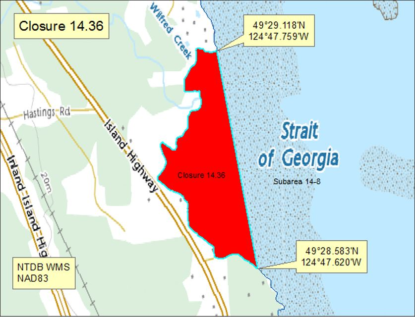
| 14.36 Mud Bay, Baynes Sound | 14.36.png | The waters and intertidal foreshore of Mud Bay, Baynes Sound, lying inside a line drawn from a point of land north of Wilfred Creek at 49°29.118' north latitude and 124°47.759' west longitude, southeast to a point on land at 49°28.583' north latitude and 124°47.620' west longitude thence following the high tide mark north to the point of commencement. [NAD83] |
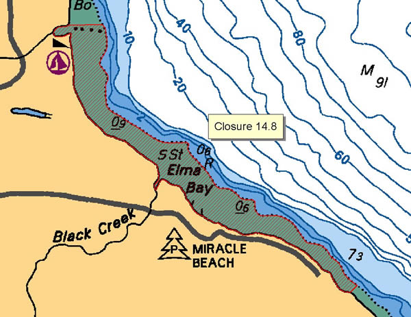
| 14.8 Elma Bay | 14.8.png | The waters and intertidal foreshore of Elma Bay, from the north side of Oyster River at a point at 49°52.35' north latitude and 125°06.90' west longitude to the south end of Elma Beach at a point at 49°50.40' north latitude and 125°03.80' west longitude. [NAD27] |
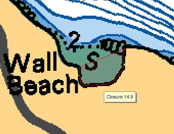
| 14.9 Wall Beach | 14.9.png | The waters and intertidal foreshore of Wall Beach, lying inside a line drawn from a point on the west shore at 49°18.12' north latitude and 124°13.33' west longitude thence easterly to a point on the shore at 49°18.22' north latitude and 124°13.08' west longitude. [NAD83] |
| 14.A Tribune Bay, Hornby Island | 14.A.png | The waters and intertidal foreshore of that portion of Subarea 14-7 inside of a line that commences at 49°30.978'N, 124°36.333'W [Tribune Bay, Hornby Island], then southwesterly to 49°30.583'N, 124°37.864'W [Dunlop Point, Tribune Bay, Hornby Island], then northeasterly to the point of commencement. [NAD83] |
| 14.B False Bay, Lasqueti Island | 14.B.png | The waters and intertidal foreshore of that portion of Subarea 14-3 inside a line that commences at 49°29.728'N, 124°22.160' [Lasqueti Island], then following the shoreline easterly to 49°29.638'N, 124°21.341'W [False Bay, Lasqueti Island], then westerly to 49°29.591'N, 124°21.721'W [Higgins Island], then following the shoreline northwesterly to 49°29.700'N, 124°22.090'W [Higgins Island], then northwesterly to the point of commencement. [NAD83] |
| 14.bg Comox Harbour | 14.bg.png | Pacific Fishery Mangement Subarea 14-14. |
| Qualicum Beach, Subarea 14-4 | Qualicum.png | Pacific Fishery Management Subarea 14-4. |
Last updated: 2026-07-02
| Area | Map | Area description |
|---|---|---|
| Coastwide | ||
| Mitlenatch Island | Those portions of Subareas 13-1, 14-13, 15-2 and 15-3 Waters within 0.5 nautical miles of Mitlenatch Island. | |
| Rathtrevor Provincial Park | The following portion of Area 14: All Crown land covered by water in Nanoose Land District commencing at the northwest corner of Lot 41, being a point on the natural boundary of the Strait of Georgia; thence north 20° E for 281.7 m, thence due east 1.79 km, thence south 12° E for 1.49 km, thence southwesterly in a straight line 1.41 km to the northeast corner of Lot 1 of Lot 59, Plan 18359, being a point on the natural boundary of Strait of Georgia; thence in a general northerly direction along the high tide line to the point of commencement. (Rathtrevor Provincial Park) | |
| Southeasterly Shoreline of Hornby Island (2) | Southeasterly Shoreline of Hornby Island (2) | Those portions of Subareas 14-5, 14-6, 14-7, 14-9, and 14-12: shoreward of a line drawn from Shingle Spit at 49°30.773' N, 124° 42.502' W southwesterly to a point in water at 49°30.674' N, 124° 42.887' W, thence southeasterly to a point on the Subarea 14-7 boundary line at 49° 28.820' N, 124° 39.541' W, thence northeasterly following the Subarea 14-7 boundary line to a point on at 49°29.030' N, 124°38.867' W, thence northeasterly to a point in water southeast of Tribune Bay at 49°30.400' N, 124°36.974' W, thence northwesterly to a point in water in Tribune Bay at 49°31.032' N, 124°38.055'W, thence northeasterly to a point in Tribune Bay at 49°31.219' N, 124° 37.776' W, thence southeasterly to a point in water at 49°30.730' N, 124°36.594' W, thence easterly to a point in water east of Flora Islet at 49°30.947' N, 124° 34.075' W, thence northwesterly to a point in water north of Cape Gurney at 49°32.189' N, 124°36.139' W, and thence southerly to a point on land on Cape Gurney at 49°31.748' N, 124°36.139' W. |
Last updated: 2026-06-09
Crab
Crab
- It is illegal to possess female Dungeness, King, Puget Sound King, Brown Box and Red Rock crabs. Female crabs must be released immediately. New
- Invasive European green crab
- Learn more about fishing for crab
Species regulations
Always check for restrictions.
| Species | Areas | Min size | Gear | Daily Limits | Status |
|---|---|---|---|---|---|
| Crab - Box | 14 | dip net, hand picking, hand picking while diving, ring net, trap | 1 | Open | |
| Crab - Dungeness | 14 | 165mm | dip net, hand picking, hand picking while diving, ring net, trap | 4 | Open |
| Crab - Dungeness and Red Rock combined | 14 | dip net, hand picking, hand picking while diving, ring net, trap | 4 | Open | |
| Crab - King | 14 | 0 | Closed | ||
| Crab - Puget Sound King | 14 | dip net, hand picking, hand picking while diving, ring net, trap | 1 | Open | |
| Crab - Red Rock | 14 | 115mm | dip net, hand picking, hand picking while diving, ring net, trap | 4 | Open |
| Crab - Shore | 14 | hand picking | 25 | Open | |
| Crab - other | 14 | dip net, hand picking, hand picking while diving, ring net, trap | 4 | Open |
Last updated: 2026-06-09
Restrictions
Always check for protected areas.
| Species | Areas | Restriction type | Restriction details |
|---|---|---|---|
| Shellfish | Rathtrevor Provincial Park | Closed | any gear or method (year round ) |
| Southeasterly Shoreline of Hornby Island (2) | Closed | any gear or method (year round ) | |
| Crab | Coastwide | Reminder | Keep navigation channels clear of buoys and lines. Any fishing gear that interferes with safe navigation can be removed under the Navigation Protection Act. |
| Coastwide | Reminder | As per the British Columbia Sport Fishing Regulations, 1996 - Maximum of 2 ring nets, dip nets or traps or combination of these per fisher. Ensure gear is properly marked. Hand picking is permitted including by diving. No sharp-pointed instruments are permitted for harvesting crab. It is illegal to use snares in catching or attempting to catch crabs. | |
| Coastwide | Reminder | Rot Cord - As per the British Columbia Sport Fishing Regulations, 1996, all crab traps must have a section in the top or sidewall that has been secured by a single length of untreated cotton twine no greater than No. 120 (approximately 5 mm or 3/16 inch diameter). This twine is often referred to as rot cord. On deterioration this must produce a rectangular opening with a minimum size of 7 cm x 20 cm, or a square opening with a minimum size of 11 cm x 11 cm. This regulation is intended to ensure that if the trap is lost, the section secured by the cord will rot, allowing captive crabs to escape, and preventing the trap from continuing to fish. On traps with a rigid frame and a freely opening hinged lid, the trap lid must be secured by a single length of untreated cotton twine no greater than No. 120 so that the trap lid will open freely when the rot cord is broken. No other fastenings may impede the hinged lid of the trap from opening. | |
| Coastwide | Reminder | Crab, prawn and shrimp floats - As a Condition of Licence, the primary float attached to crab traps must be cylindrical in shape (includes bullet shaped) and a minimum of 27 cm in length and 12 cm in diameter; an optional secondary float may be used of any shape or size other than spherical. The primary float attached to prawn and shrimp traps must be spherical in shape and a minimum of 27 cm in diameter; an optional secondary float may be used of any shape or size other than cylindrical. | |
| Coastwide | Reminder | Floats must be made of a durable material and suitable for operation in marine waters. Floats/materials not suitable for use in marine waters are prohibited. | |
| Coastwide | Reminder | As per the British Columbia Sport Fishing Regulations, 1996 - Traps must be marked with a tag, float or buoy that has your name and telephone number on it. This includes traps tied to a boat or dock or fished from shore. If two traps are attached to one ground-line, it is sufficient to attach a tag, float or buoy that bears the operator's name and telephone number to one end of the ground-line. | |
| Coastwide | Reminder | As per the British Columbia Sport Fishing Regulations, 1996 - A line or rope attached to a trap must be submerged in such a manner that the line or rope does not come into contact with a person or a boat. | |
| Coastwide | Reminder | When Open, the Possession Limit for crab is twice the Daily Limit. | |
| Coastwide | Reminder | As a Condition of Licence, crab traps are required to have two unobstructed circular escape holes or rings, measuring a minimum of 105 mm in diameter. | |
| 14 | Time of Day Restrictions | Daylight hours - It is illegal to set or haul crab traps from one hour after sunset to one hour before sunrise. Overnight soaking of traps is allowed. | |
| Crab - Box | Southeasterly Shoreline of Hornby Island (2) | Closed | diving (year round ), hand picking while diving (year round ), spear fishing while diving (year round ) |
| Crab - Dungeness | Southeasterly Shoreline of Hornby Island (2) | Closed | diving (year round ), hand picking while diving (year round ), spear fishing while diving (year round ) |
| Coastwide | Packaging and Transporting | In order to be accurately measured, the carapace of Dungeness crab that you catch must remain attached until the crab arrives at your residence or it is consumed. | |
| Coastwide | Sex Restriction | It is prohibited to possess female Dungeness crab. | |
| Crab - Red Rock | Southeasterly Shoreline of Hornby Island (2) | Closed | diving (year round ), hand picking while diving (year round ), spear fishing while diving (year round ) |
| Coastwide | Packaging and Transporting | In order to be accurately measured, the carapace of Red Rock crab that you catch must remain attached until the crab arrives at your residence or it is consumed. | |
| Coastwide | Sex Restriction | It is prohibited to possess female Red Rock crab. | |
| Crab - King | Southeasterly Shoreline of Hornby Island (2) | Closed | diving (year round ), hand picking while diving (year round ), spear fishing while diving (year round ) |
| Coastwide | Packaging and Transporting | In order to be accurately measured, the carapace of King crab that you catch must remain attached until the crab arrives at your residence or it is consumed. | |
| Coastwide | Sex Restriction | It is prohibited to possess female King crab. | |
| Crab - Puget Sound King | Southeasterly Shoreline of Hornby Island (2) | Closed | diving (year round ), hand picking while diving (year round ), spear fishing while diving (year round ) |
| Coastwide | Sex Restriction | As a Condition of Licence, it is prohibited to possess female Puget Sound King Crab. | |
| Crab - Brown Box | Coastwide | Sex Restriction | As a Condition of Licence, it is prohibited to possess female Brown Box Crab. |
Last updated: 2026-06-09
Area descriptions
| Area | Map | Area description |
|---|---|---|
| Coastwide | ||
| Rathtrevor Provincial Park | The following portion of Area 14: All Crown land covered by water in Nanoose Land District commencing at the northwest corner of Lot 41, being a point on the natural boundary of the Strait of Georgia; thence north 20° E for 281.7 m, thence due east 1.79 km, thence south 12° E for 1.49 km, thence southwesterly in a straight line 1.41 km to the northeast corner of Lot 1 of Lot 59, Plan 18359, being a point on the natural boundary of Strait of Georgia; thence in a general northerly direction along the high tide line to the point of commencement. (Rathtrevor Provincial Park) | |
| Southeasterly Shoreline of Hornby Island (2) | Southeasterly Shoreline of Hornby Island (2) | Those portions of Subareas 14-5, 14-6, 14-7, 14-9, and 14-12: shoreward of a line drawn from Shingle Spit at 49°30.773' N, 124° 42.502' W southwesterly to a point in water at 49°30.674' N, 124° 42.887' W, thence southeasterly to a point on the Subarea 14-7 boundary line at 49° 28.820' N, 124° 39.541' W, thence northeasterly following the Subarea 14-7 boundary line to a point on at 49°29.030' N, 124°38.867' W, thence northeasterly to a point in water southeast of Tribune Bay at 49°30.400' N, 124°36.974' W, thence northwesterly to a point in water in Tribune Bay at 49°31.032' N, 124°38.055'W, thence northeasterly to a point in Tribune Bay at 49°31.219' N, 124° 37.776' W, thence southeasterly to a point in water at 49°30.730' N, 124°36.594' W, thence easterly to a point in water east of Flora Islet at 49°30.947' N, 124° 34.075' W, thence northwesterly to a point in water north of Cape Gurney at 49°32.189' N, 124°36.139' W, and thence southerly to a point on land on Cape Gurney at 49°31.748' N, 124°36.139' W. |
Last updated: 2026-06-09
Other invertebrates
Other invertebrates
- Basic information about shellfish harvesting
- Seasonal recreational harvesting closures for prawn and shrimp
Species regulations
Always check for restrictions.
| Species | Areas | Gear | Daily Limits | Status |
|---|---|---|---|---|
| Abalone | 14 | 0 | Closed | |
| Barnacles - Giant | 14 | diving | 6 | Open |
| Barnacles - Goose | 14 | hand picking | 2kg | Open |
| Invertebrates - all other species | 14 | angling, dip net, hand digging, hand picking, hand picking while diving, hand picking while snorkeling, hand pump, ring net, spear fishing while diving, trap | 20 | Open |
| Limpet | 14 | hand picking | 75 | Open |
| Octopus | 14 | angling, hand picking, hand picking while diving, trap | 1 | Open |
| Sand Dollar | 14 | hand picking | 6 | Open |
| Sea Cucumber | 14 | hand picking, hand picking while diving | 12 | Open |
| Sea Star or Starfish | 14 | diving, hand picking | 6 | Open |
| Sea Urchin | 14 | hand picking, hand picking while diving | 12 | Open |
| Shellfish - all other species | 14 | angling, dip net, hand digging, hand picking, hand picking while diving, hand pump, ring net, spear fishing while diving, trap | 20 | Open |
| Shrimp - Ghost | 14 | hand digging, hand pump | 50 | Open |
| Shrimp including prawn | 14 | ring net, spear fishing while diving, trap | 125 | Open |
| Squid - Opal | 14 | cast net, jigging | 200 | Open |
| Squid - all other species | 14 | cast net, jigging | 20 | Open |
Last updated: 2026-06-09
Restrictions
Always check for protected areas.
| Species | Areas | Restriction type | Restriction details |
|---|---|---|---|
| Shellfish | Rathtrevor Provincial Park | Closed | any gear or method (year round ) |
| Southeasterly Shoreline of Hornby Island (2) | Closed | any gear or method (year round ) | |
| Other Invertebrates | Coastwide | Reminder | When Open, the Possession Limit for other invertebrates is twice the Daily Limit. |
| Coastwide | Reminder | Rot Cord - As per the British Columbia Sport Fishing Regulations, 1996, all open mesh octopus traps and shrimp/prawn traps must have a section in the top or sidewall that has been secured by a single length of untreated cotton twine no greater than No. 120 (approximately 5 mm or 3/16 inch diameter). This twine is often referred to as rot cord. On deterioration this must produce a rectangular opening with a minimum size of 7 cm x 20 cm, or a square opening with a minimum size of 11 cm x 11 cm. This regulation is intended to ensure that if the trap is lost, the section secured by the cord will rot, allowing captive crabs to escape, and preventing the trap from continuing to fish. On traps with a rigid frame and a freely opening hinged lid the trap lid must be secured by a single length of untreated cotton twine no greater than No. 120 so that the trap lid will open freely when the rot cord is broken. No other fastenings may impede the hinged lid of the trap from opening. | |
| Coastwide | Reminder | Floats must be made of a durable material and suitable for operation in marine waters. Floats/materials not suitable for use in marine waters are prohibited. | |
| Coastwide | Reminder | As per the British Columbia Sport Fishing Regulations, 1996 - A line or rope attached to a trap must be submerged in such a manner that the line or rope does not come into contact with a person or a boat. | |
| Coastwide | Reminder | As per the British Columbia Sport Fishing Regulations, 1996 - Traps must be marked with a tag, float or buoy that has your name and telephone number on it. This includes traps tied to a boat or dock or fished from shore. If two traps are attached to one ground-line, it is sufficient to attach a tag, float or buoy that bears the operator's name and telephone number to one end of the ground-line. | |
| Barnacles - Giant | Southeasterly Shoreline of Hornby Island (2) | Closed | diving (year round ), hand picking while diving (year round ), spear fishing while diving (year round ) |
| Octopus | Southeasterly Shoreline of Hornby Island (2) | Closed | diving (year round ), hand picking while diving (year round ), spear fishing while diving (year round ) |
| Coastwide | Reminder | The use of sharp pointed instruments or chemicals is prohibited. | |
| Sea Cucumber | Southeasterly Shoreline of Hornby Island (2) | Closed | diving (year round ), hand picking while diving (year round ), spear fishing while diving (year round ) |
| Sea Urchin | Southeasterly Shoreline of Hornby Island (2) | Closed | diving (year round ), hand picking while diving (year round ), spear fishing while diving (year round ) |
| Shrimp including prawn | Southeasterly Shoreline of Hornby Island (2) | Closed | diving (year round ), hand picking while diving (year round ), spear fishing while diving (year round ) |
| Coastwide | Reminder | Spot Prawns (Pandalus platyceros) with eggs - No person shall retain prawns carrying eggs, or remove eggs from the underside of prawns carrying eggs. All prawns carrying eggs externally on the underside of the tail shall be returned to the water immediately and in the manner that causes the least harm. | |
| Coastwide | Reminder | Crab, prawn and shrimp floats - As a Condition of Licence, the primary float attached to crab traps must be cylindrical in shape (includes bullet shaped) and a minimum of 27 cm in length and 12 cm in diameter; an optional secondary float may be used of any shape or size other than spherical. The primary float attached to prawn and shrimp traps must be spherical in shape and a minimum of 27 cm in diameter; an optional secondary float may be used of any shape or size other than cylindrical. | |
| Coastwide | Reminder | As per the British Columbia Sport Fishing Regulations, 1996 - Maximum 4 traps or ring nets or combination of these per fisher. | |
| Sea Star or Starfish | Southeasterly Shoreline of Hornby Island (2) | Closed | diving (year round ), hand picking while diving (year round ), spear fishing while diving (year round ) |
| Shellfish - all other species | Southeasterly Shoreline of Hornby Island (2) | Closed | diving (year round ), hand picking while diving (year round ), spear fishing while diving (year round ) |
Last updated: 2026-06-09
Area descriptions
| Area | Map | Area description |
|---|---|---|
| Coastwide | ||
| Rathtrevor Provincial Park | The following portion of Area 14: All Crown land covered by water in Nanoose Land District commencing at the northwest corner of Lot 41, being a point on the natural boundary of the Strait of Georgia; thence north 20° E for 281.7 m, thence due east 1.79 km, thence south 12° E for 1.49 km, thence southwesterly in a straight line 1.41 km to the northeast corner of Lot 1 of Lot 59, Plan 18359, being a point on the natural boundary of Strait of Georgia; thence in a general northerly direction along the high tide line to the point of commencement. (Rathtrevor Provincial Park) | |
| Southeasterly Shoreline of Hornby Island (2) | Southeasterly Shoreline of Hornby Island (2) | Those portions of Subareas 14-5, 14-6, 14-7, 14-9, and 14-12: shoreward of a line drawn from Shingle Spit at 49°30.773' N, 124° 42.502' W southwesterly to a point in water at 49°30.674' N, 124° 42.887' W, thence southeasterly to a point on the Subarea 14-7 boundary line at 49° 28.820' N, 124° 39.541' W, thence northeasterly following the Subarea 14-7 boundary line to a point on at 49°29.030' N, 124°38.867' W, thence northeasterly to a point in water southeast of Tribune Bay at 49°30.400' N, 124°36.974' W, thence northwesterly to a point in water in Tribune Bay at 49°31.032' N, 124°38.055'W, thence northeasterly to a point in Tribune Bay at 49°31.219' N, 124° 37.776' W, thence southeasterly to a point in water at 49°30.730' N, 124°36.594' W, thence easterly to a point in water east of Flora Islet at 49°30.947' N, 124° 34.075' W, thence northwesterly to a point in water north of Cape Gurney at 49°32.189' N, 124°36.139' W, and thence southerly to a point on land on Cape Gurney at 49°31.748' N, 124°36.139' W. |
Last updated: 2026-06-09
Protected areas
Protected areas
Learn about permanent restrictions that are in effect:
Find detailed maps and coordinates for protected areas in the Canadian Pacific
Learn about rules you need to follow to protect Southern Resident killer whales
| Area | Type | Closure name |
|---|---|---|
| 14-2 | Glass Sponge Reef | Parksville |
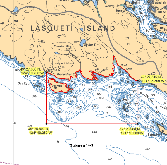
| 14-3 | Rockfish Conservation Area | Lasqueti Island South |
| Glass Sponge Reef | Parksville | |
| Rockfish Conservation Area | Sisters Islets | |
| 14-4 | Rockfish Conservation Area | Sisters Islets |
| 14-5 | Rockfish Conservation Area | Sisters Islets |
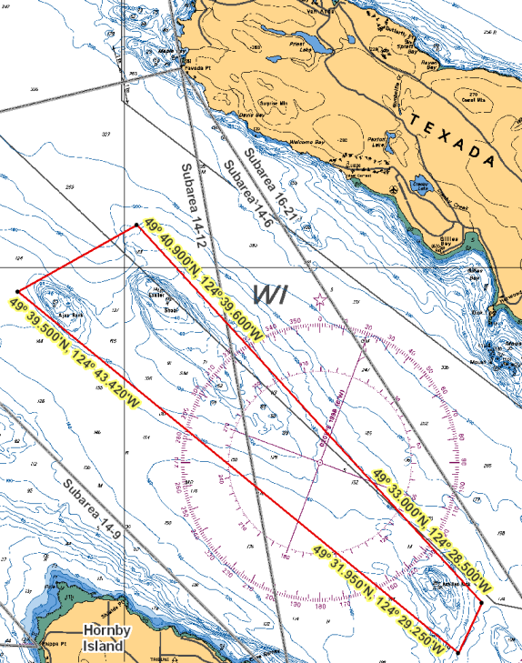
| 14-6 | Rockfish Conservation Area | Ajax-Achilles Bank |
| Glass Sponge Reef | East of Hornby Islands | |
| Rockfish Conservation Area | Sisters Islets | |
| 14-7 | Rockfish Conservation Area | Savoie Rocks - Maude Reef |
| 14-8 | Rockfish Conservation Area | Baynes Sound |
| Chrome Island | ||
| 14-12 | Rockfish Conservation Area | Ajax-Achilles Bank |
| 14-13 | Rockfish Conservation Area | Mitlenatch Island |
| Oyster Bay |
Last updated: 2026-06-09
Area descriptions
| Area | Map | Area description |
|---|---|---|
| Ajax-Achilles Bank | Ajax-Achilles Bank | Those waters of Subareas 14-6 and 14-12 that lie inside a line that: begins at 49°39.500'N 124°43.420'W in water then to 49°40.900'N 124°39.600'W in water then to 49°33.000'N 124°28.500'W in water then to 49°31.950'N 124°29.250'W in water then to the beginning point. |
| Baynes Sound | Baynes Sound | Those waters of Subarea 14-8 that lie inside a line that: begins at 49°31.200'N 124°48.100'W in water then to 49°30.200'N 124°46.500'W in water then to 49°29.900'N 124°47.100'W in water then to 49°30.800'N 124°48.700'W in water then to the beginning point. |
| Chrome Island | Chrome Island | Those waters of Subarea 14-8 that lie inside a line that: begins at 49°28.489'N 124°41.129'W Boyle Point then to 49°28.332'N 124°41.112'W Chrome Island Light then to 49°28.067'N 124°43.700'W Mapleguard Point then to 49°28.311'N 124°44.195'W Mapleguard Buoy then to 49°28.918'N 124°43.946'W Repulse Point then easterly following the shoreline to the beginning point. |
| East of Hornby Islands | East of Hornby Islands | That portion of Subarea 14-6 that lie inside a line that: begins at 49°33.490'N 124°29.230'W then southerly to 49°32.701'N 124°28.760'W then to 49°31.657'N 124°29.434'W then to 49°31.663'N 124°29.896'W then to 49°32.651'N 124°29.752'W then to 49°33.340'N 124°29.935'W then to 49°33.498'N 124°29.773'W then to the beginning point. |
| Lasqueti Island South | Lasqueti Island South | Those waters of Subarea 14-3 the lie inside a line that: begins at 49°27.315'N 124°13.300'W east of Boat Cove then to 49°25.800'N 124°13.300'W in water then to 49°25.800'N 124°18.250'W in water then to 49°27.600'N 124°18.250'W near Jenkins Creek then following the shoreline to the beginning point. |
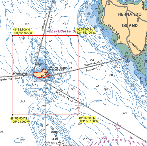
| Mitlenatch Island | Mitlenatch Island | Those waters of Subareas 13-1, 14-13, 15-2 and 15-3 that lie inside a line that: begins at 49°58.500'N 125°01.900'W in water then to 49°58.500'N 124°58.100'W in water then to 49°55.500'N 124°58.100'W in water then to 49°55.500'N 125°01.900'W in water then to the beginning point. |
| Oyster Bay | Oyster Bay | Those waters of Subarea 14-13 that lie inside a line that: begins at 49°55.600'N 125°10.947'W south of Shelter Point then to 49°55.600'N 125°06.100'W in water then to 49°53.900'N 125°09.000'W shoreline then across Oyster Bay to the beginning point. |
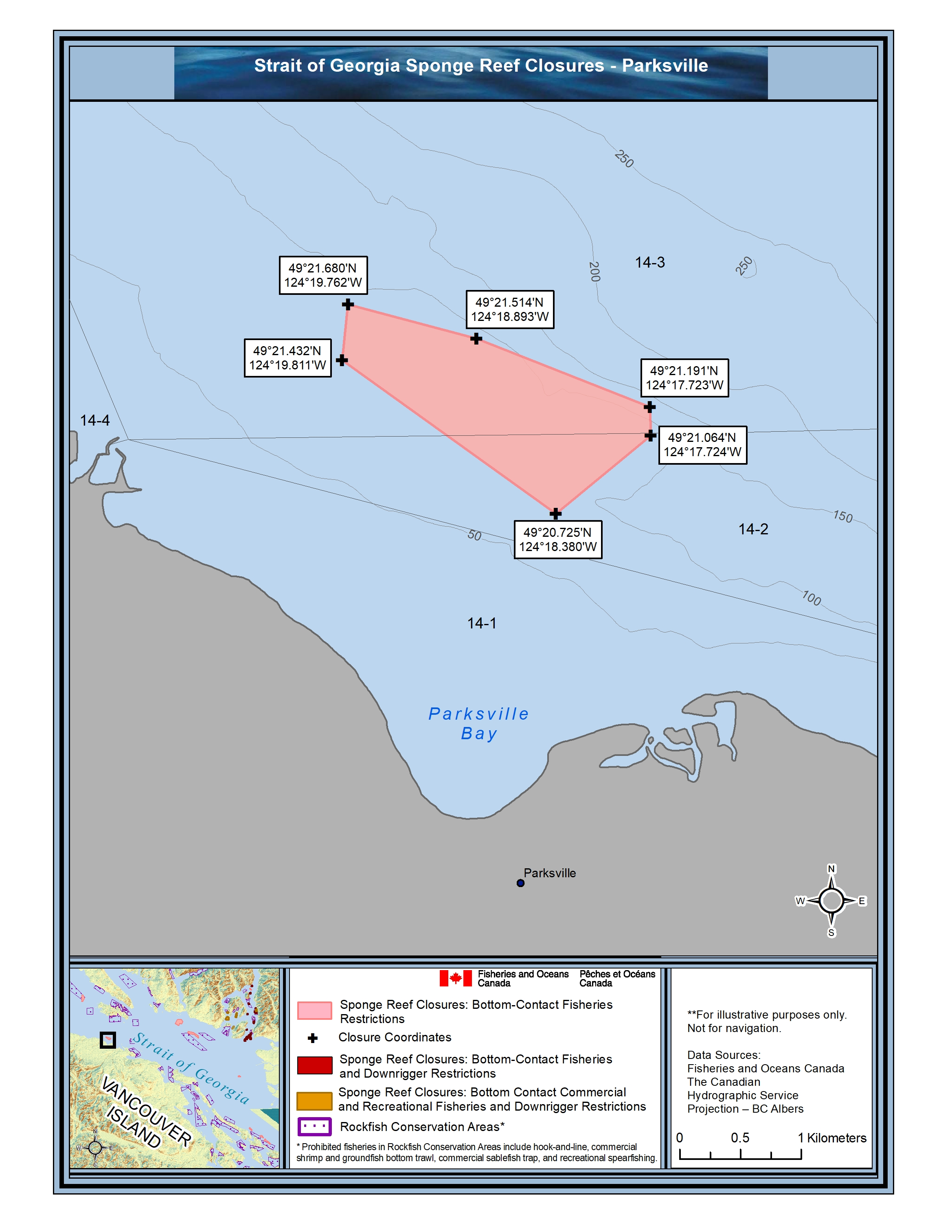
| Parksville | Parksville | Those portions of Subareas 14-2 and 14-3 that lie inside a line that: begins at 49°21.680'N 124°19.762'W then southeasterly to 49°21.514'N 124°18.893'W then to 49°21.191'N 124°17.723'W then to 49°21.064'N 124°17.724'W then to 49°20.725'N 124°18.380'W then to 49°21.432'N 124°19.811'W then to the beginning point. |
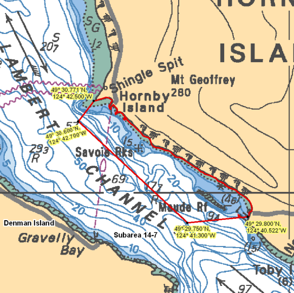
| Savoie Rocks - Maude Reef | Savoie Rocks - Maude Reef | Those waters of Subarea 14-7 that lie inside a line that: begins at 49°29.800'N 124°40.522'W north of Norman Point then to 49°29.750'N 124°41.300'W in water then to 49°30.600'N 124°42.700'W in water then to 49°30.771'N 124°42.500'W Shingle Spit then southeasterly following the shoreline to the beginning point. |
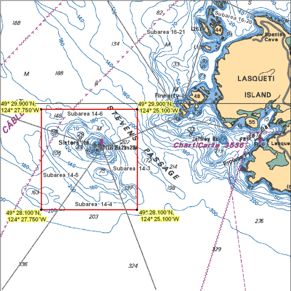
| Sisters Islets | Sisters Islets | Those waters of Subareas 14-3 to 14-6 that lie inside a line that: begins at 49°29.900'N 124°27.750'W in water then to 49°29.900'N 124°25.100'W in water then to 49°28.100'N 124°25.100'W in water then to 49°28.100'N 124°27.750'W in water then to the beginning point. |
Last updated: 2026-06-09
- Date modified: