
BC tidal area 18 Saltspring, Pender, Mayne and Saturna Islands, and Saanich Peninsula: Recreational fishing limits, openings and closures
Licence holders must follow fishing regulations unless otherwise specified in the Conditions of Licence.
How to follow the rules
- Make sure you have a current BC Tidal Waters sport fishing licence with you at all times. Are you using the FishingBC App for electronic licensing and catch recording? Learn more.
- Check the Area map. You need to know the location (subarea) where you plan to fish.
- Check the species regulations tables for fishing opportunities and basic regulations.
- Check the restrictions tables for special exceptions and more detailed regulations. Make sure you know the:
- Daily limit: The maximum number of a given fish species that a person is allowed to keep in one day.
- Possession limit: The maximum number of fish you can have in your possession at any given time, except for what is at your ordinary residence. The possession limit for most species is double the daily limit.
- Annual limit: The total amount of fish of a certain species that may be caught and retained during the course of a fishing year which starts on April 1 and ends the following March 31. Check "Restrictions" under each section for annual limits by species.
- Get to know the locations of protected areas. Permanent fishing restrictions are in effect in these areas to protect fish and fish habitat.
- Unless otherwise specified, fishing opportunities and closures end at 23:59 hrs on the close-date shown.
Related links
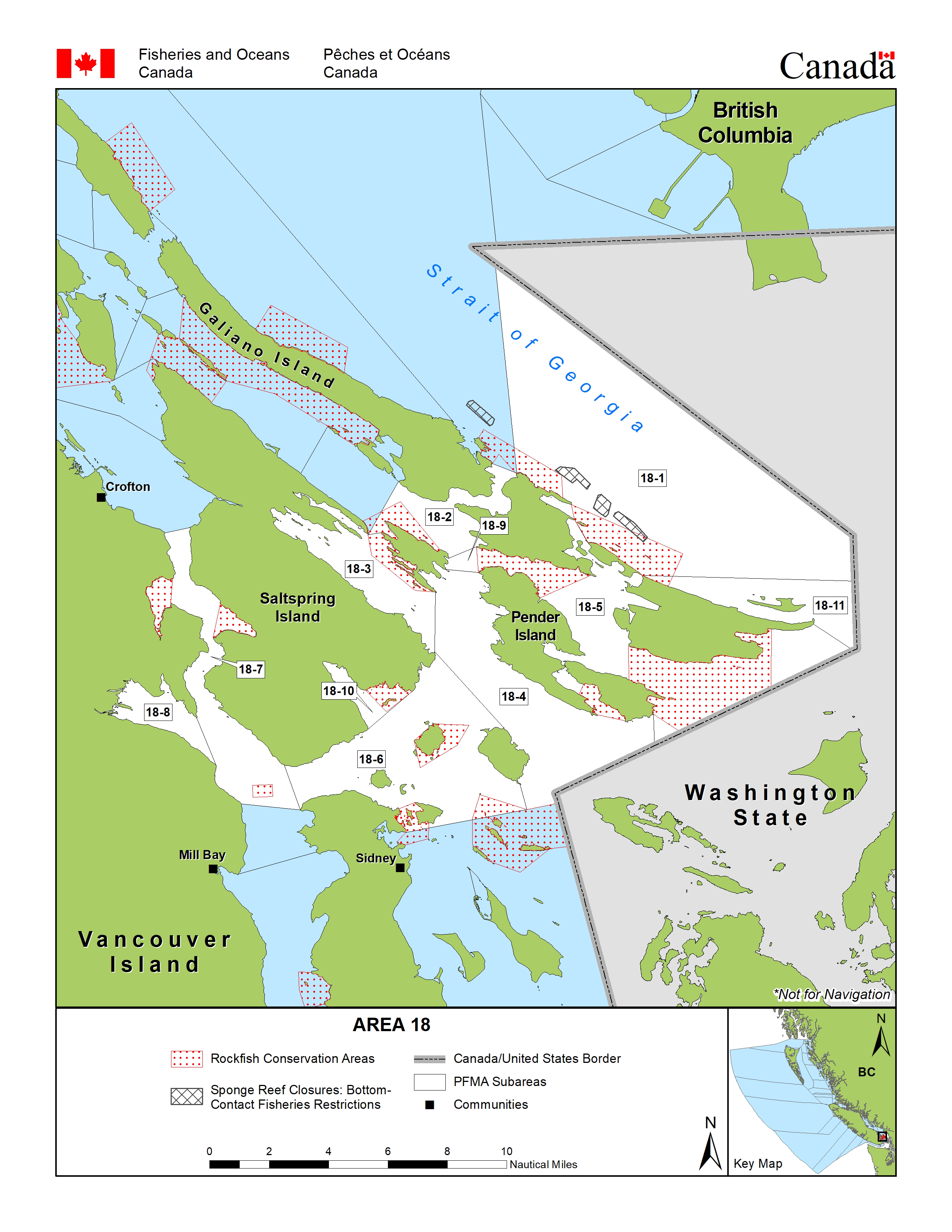
Area map
Area maps
This map is for information only and should not be used for fishing, navigation or other purposes.
For a written description of Areas please see the Pacific Fishery Management Area Regulations 2007.
Area 18: Download a printable PDF version of this map.
Salmon
Salmon
- You must have a valid a salmon conservation stamp on your BC Tidal Waters sport fishing licence if you plan to retain salmon.
- You must immediately and permanently record all retained chinook salmon on your paper licence, your NRLS catch log or your NRLS-linked FishingBC app catch log.
- Learn more about fishing for salmon
Maps
- Management measures to protect Southern Resident killer whales
- Area 18, Saltspring, Pender, Mayne and Saturna Islands, and Saanich Peninsula: coho salmon openings and other management measures
Species regulations
Always check for restrictions.
| Species | Areas | Min size | Gear | Daily Limits | Status |
|---|---|---|---|---|---|
| Chinook salmon (hatchery and wild combined) | 18-1 to 18-6 and 18-8 to 18-11 | 62cm | barbless hook and line | 0 | Non Retention |
| 18-7 | 62cm | barbless hook and line | 1 Combined Total * Consisting of no more than:
|
Open | |
| Chum salmon | 18 | 30cm | barbless hook and line | 2 | Open |
| Coho salmon (hatchery and wild combined) | 18 | 30cm | barbless hook and line | 2 Combined Total * Consisting of no more than:
|
Open |
| Pink salmon | 18 | 30cm | barbless hook and line | 4 | Open |
| Sockeye salmon | 18 | 30cm | barbless hook and line | 0 | Non Retention |
Last updated: 2026-06-09
Restrictions
Always check for protected areas.
| Species | Areas | Restriction type | Restriction details |
|---|---|---|---|
| Finfish | Pender Island Vessel Restricted Zone | Closed | No vessels or fishing (with some exceptions) in the Vessel Restricted Zones located in a portion of Subarea 18-4 and in portions of 18-5 and 18-11. Human-powered vessels (kayaks, canoes, etc.) may use a 20 m transit corridor along the shoreline. |
| Saturna Island Vessel Restricted Zone | Closed | No vessels or fishing (with some exceptions) in the Vessel Restricted Zones located in a portion of Subarea 18-4 and in portions of 18-5 and 18-11. Human-powered vessels (kayaks, canoes, etc.) may use a 20 m transit corridor along the shoreline. | |
| Salmon | Portion of subarea 18-6 | Gear Restriction | You are not allowed to harvest using the following gears and methods:
|
| Coastwide | Daily Limit Pieces | 4 - The daily limit for all species of Pacific salmon from tidal and fresh waters combined is four. Individual species limits also apply. | |
| 18-7 | Gear Restriction | You are not allowed to harvest using the following gears and methods:
|
|
| 18 | Gear Restriction | You are not allowed to harvest using the following gears and methods:
|
|
| Coastwide | Reminder | When Open, the Possession Limit for salmon is twice the Daily Limit. | |
| Coastwide | Reminder | Hatchery (marked) salmon - Chinook and coho salmon with a healed scar in place of the adipose fin. | |
| Chinook salmon (hatchery and wild combined) | Portion of subarea 18-6 | Daily Limit Pieces | 1 Combined Total * Consisting of no more than:
|
| Coastwide | Annual Limit Pieces | 10 - The coastwide total annual limit for chinook salmon is 10 from all tidal waters that are open to chinook retention. | |
| Coastwide | Reminder | Keeping your chinook salmon? You must permanently record all retained chinook salmon (head-on length) on your Tidal Waters Sport Fishing Licence. The licence holder may alternatively record retained catch immediately in an electronic licence held in an approved third-party application linked to their National Recreational Licensing System (NRLS) account, or if mobile internet access is immediately available, directly in their NRLS account. The licence holder shall ensure that all mandatory catch records for the current licence year are produced, either on the licence (paper or electronic), or from the licence holder's NRLS account at the time of inspection. |
Last updated: 2026-06-09
Area descriptions
| Area | Map | Area description |
|---|---|---|
| Coastwide | ||
| Pender Island Vessel Restricted Zone | Pender Island Vessel Restricted Zone | That portion of Subarea 18-4 west of Pender Island inside a line commencing at a point at 48°44.167'N and 123°13.917'W [Southeast Boundary (Wallace Point)] westerly to a point in water located at 48°44.153'N and 123°15.517'W [Southwest Boundary (Swanson Channel)], thence northwesterly to a point in water at 48°45.817'N and 123°19.300'W [Northwest Boundary (Swanson Channel)], thence northeasterly to point at 48°46.217'N and 123°18.867'W [Northeast Boundary (South of Thieves Bay)], and thence southeasterly following the shoreline back to the point of commencement. |
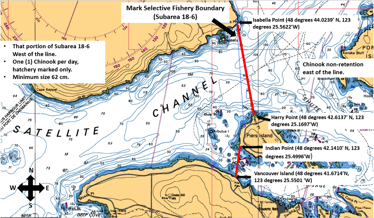
| Portion of subarea 18-6 | Portion of subarea 18-6 | That portion of Subarea 18-6 west of a line from Isabella Point on Saltspring Island (48°44.0239'N, 123°25.5622'W) to Harry Point on Piers Island (48°42.6137'N, 123°25.1697'W); AND west of a line from Indian Point on Piers Island (48°42.1410'N, 123°25.4996'W), then through the red buoy U16, then through the green marker on metal pilings, then due south to a point on Vancouver Island (48°41.6714'N, 123°25.5501'W). |
| Saturna Island Vessel Restricted Zone | Saturna Island Vessel Restricted Zone | Those portions of Subareas 18-5 and 18-11 off Saturna Island inside a line commencing on the shoreline of Saturna Island northwesterly at 48°47.150' north latitude and 123°02.733' west longitude [North Boundary East Point], then northwesterly to a point in water at 48°47.367' north latitude and 123°02.915' west longitude [Tumbo Channel], thence northeasterly to a point in water at 48°47.617' north latitude and 123°02.483' west longitude [Northwest Corner(East of Tumbo Point)], thence southeasterly to a point in water at 48°47.473' north latitude and 123°01.975 west longitude [Northeast Corner (Boiling Reef)], thence southwesterly to a point in water at 48°46.558' north latitude and 123°03.147' west longitude [Boundary Pass], thence southwesterly to a point in water at 48°46.333' north latitude and 123°03.805' west longitude [Southeast Corner], thence westerly to a point in water at 48°46.350' north latitude and 123°05.150' west longitude [Southwest Corner (Narvaez Bay)], thence due north to a point in water at 48°46.683'N and 123°05.150'W [Fiddler's Cove], and thence northeasterly along the shoreline back to the point of commencement. |
Last updated: 2026-06-09
Other finfish
Finfish other than salmon
- You must immediately and permanently record the following retained catch on your paper licence, your NRLS catch log or your NRLS-linked FishingBC app catch log.
- halibut
- lingcod caught in Areas 12 to 19 (excluding Subarea 12-14) and Subareas 20-5 to 20-7 and 29-5
- Check the Restrictions for the current possession limit for Pacific halibut
- Learn more about fishing for finfish
Species regulations
Always check for restrictions.
| Species | Areas | Min size | Gear | Daily Limits | Status |
|---|---|---|---|---|---|
| Codfish | 18 | angling, spear fishing while diving | 8 | Open | |
| Eulachon | 18 | 0kg | Closed | ||
| Finfish - all other species | 18 | angling, dip net, herring jig, herring rake, spear fishing while diving | 20 | Open | |
| Greenling | 18 | angling, spear fishing while diving | 3 | Open | |
| Halibut | 18 | angling, spear fishing while diving | 1 | Open | |
| Herring | 18 | cast net, dip net, herring jig, herring rake | 20kg | Open | |
| Lingcod | 18 | 65cm | angling, spear fishing while diving | 1 | Open |
| Mackerel | 18 | angling, dip net, herring jig, herring rake, spear fishing while diving | 100 | Open | |
| Northern Anchovy | 18 | cast net, dip net, herring jig, herring rake | 20kg | Open | |
| Pacific sand lance | 18 | cast net, dip net, herring jig, herring rake | 5kg | Open | |
| Pacific sardine | 18 | angling, dip net, herring jig, herring rake, spear fishing while diving | 100 | Open | |
| Rockfish - Yelloweye | 18 | angling, spear fishing while diving | 0 | Non Retention | |
| Rockfish - all species except Yelloweye | 18 | angling, spear fishing while diving | 1 | Open | |
| Sablefish | 18 | angling | 4 | Open | |
| Sculpin | 18 | angling | 8 | Open | |
| Shark - Basking | 18 | 0 | Closed | ||
| Shark - Blue | 18 | 0 | Closed | ||
| Shark - Brown Cat | 18 | 0 | Closed | ||
| Shark - Great White | 18 | 0 | Closed | ||
| Shark - Salmon | 18 | angling, spear fishing while diving | 1 | Open | |
| Shark - Sixgill | 18 | 0 | Closed | ||
| Shark - Tope | 18 | 0 | Closed | ||
| Shark - all other species | 18 | 0 | Closed | ||
| Skate | 18 | angling | 1 | Open | |
| Smelt | 18 | dip net, gill net | 20kg | Open | |
| Sole or Flounder | 18 | angling, spear fishing while diving | 8 | Open | |
| Spiny Dogfish | 18 | angling, spear fishing while diving | 0 | Non Retention | |
| Surfperch | 18 | angling | 8 | Open | |
| Tuna - Albacore | 18 | angling, spear fishing while diving | 20 | Open | |
| Tuna - Pacific bluefin | 18 | angling, spear fishing while diving | 20 | Open | |
| Tuna - all other species | 18 | angling, spear fishing while diving | 20 | Open | |
| White Sturgeon | 18 | angling | 0 | Non Retention | |
| Wolf Eel | 18 | angling | 0 | Non Retention |
| Species | Areas | Min size | Gear | Daily Limits | Status |
|---|---|---|---|---|---|
| Trout (hatchery and wild combined) | 18 | 30cm | angling | 2 Combined Total * Consisting of no more than:
|
Open |
Last updated: 2026-06-10
Restrictions
Always check for protected areas.
| Species | Areas | Restriction type | Restriction details |
|---|---|---|---|
| Finfish | Pender Island Vessel Restricted Zone | Closed | No vessels or fishing (with some exceptions) in the Vessel Restricted Zones located in a portion of Subarea 18-4 and in portions of 18-5 and 18-11. Human-powered vessels (kayaks, canoes, etc.) may use a 20 m transit corridor along the shoreline. |
| Saturna Island Vessel Restricted Zone | Closed | No vessels or fishing (with some exceptions) in the Vessel Restricted Zones located in a portion of Subarea 18-4 and in portions of 18-5 and 18-11. Human-powered vessels (kayaks, canoes, etc.) may use a 20 m transit corridor along the shoreline. | |
| Other Finfish | Coastwide | Reminder | When Open, the Possession Limit for finfish other than salmon is twice the Daily Limit – except for Halibut (see Restrictions section). |
| Herring | Coastwide | Reminder | Harvesting of herring roe from marine plants or plants placed in the water for the purpose of harvesting herring roe is prohibited. |
| Eulachon | Coastwide | Closed | Due to conservation concerns the harvesting of eulachon is prohibited. |
| Codfish | Coastwide | Reminder | Species includes - Pacific cod, Pacific tomcod, pollock and hake but does not include lingcod. |
| Halibut | Coastwide | Reminder | As a Condition of Licence, no person shall catch and retain more than ten (10) Halibut in the aggregate from April 1, 2026 to March 31, 2027. No person shall retain a Halibut greater than 112 cm head-on length (85 cm pectoral length (head-off)). The possession limit is equal to the daily limit. Head-off measurements are made from the base of the pectoral fin at its most forward point to the extreme end of the middle of the tail. |
| Coastwide | Reminder | You must permanently record all retained Halibut (head-on length) on your Tidal Waters Sport Fishing Licence. The licence holder may alternatively record retained catch immediately in an electronic licence held in an approved third-party application linked to their National Recreational Licensing System (NRLS) account, or if mobile internet access is immediately available, directly in their NRLS account. The licence holder shall ensure that all mandatory catch records for the current licence year are produced, either on the licence (paper or electronic), or from the licence holder's NRLS account at the time of inspection. | |
| Lingcod | 18 | Annual Limit Pieces | 10 - The total annual limit for lingcod is 10 from the following tidal areas when they are open to lingcod retention - Areas 12 to 19 (excluding Subarea 12-14), Subareas 20-5 to 20-7, and 29-5. |
| 18 | Reminder | Areas 12 to 19 (excluding Subarea 12-14), Subareas 20-5 to 20-7, and 29-5 - You must permanently record all retained Lingcod on your Tidal Waters Sport Fishing Licence. The licence holder may alternatively record retained catch immediately in an electronic licence held in an approved third-party application linked to their National Recreational Licensing System (NRLS) account, or if mobile internet access is immediately available, directly in their NRLS account. The licence holder shall ensure that all mandatory catch records for the current licence year are produced, either on the licence (paper or electronic), or from the licence holder's NRLS account at the time of inspection. | |
| Coastwide | Reminder | The pectoral length (head -off) requirement for Lingcod is 53 cm. Pectoral length (head-off) measurements are made from the base of the pectoral fin at its most forward point to the extreme end of the middle of the tail. | |
| Coastwide | Season Planning | For planning purposes only: For in-season requirements, please see current regulations/restrictions for specific areas, gear and individual species limits, and closures/exceptions. INSIDE WATERS - Generally open May 1 to September 30, for Areas 13 to 19 and Subareas 12-1 to 12-13, 12-15 to 12-48, 20-5 to 20-7 and 29-5. Closed year round - Area 28 and Subareas 29-1 to 29-4 and 29-6 to 29-17. OUTSIDE WATERS - Generally open April 1 to November 15, for Areas 1 to 10, 101 to 110, 130, 142, 11, 21 to 27, 111, 123 to 127, Subareas 12-14 and 20-1 to 20-4, and Area 121 (portion). | |
| Perch | Coastwide | Reminder | Includes kelp, shiner and pile perch, and all species of surf and sea perch. |
| Rockfish | Coastwide | Reminder | Anglers in vessels shall immediately return all rockfish that are not being retained to the water and to a similar depth from which they were caught by use of an inverted weighted barbless hook or other purpose-built descender device. |
| Coastwide | Season Planning | For planning purposes only: For in-season requirements, please see current regulations/restrictions for specific areas, gear and individual species limits, and closures/exceptions. INSIDE WATERS - Generally open May 1 to September 30, for Areas 13 to 19 and Subareas 12-1 to 12-13, 12-15 to 12-48, 20-5 to 20-7 and 29-5. Closed year round - Area 28 and Subareas 29-1 to 29-4 and 29-6 to 29-17. OUTSIDE WATERS - Generally Open April 1 to November 15, for Areas 1 to 10, 101 to 110, 130, 142, 11, 21 to 27, 111, 123 to 127, Subareas 12-14 and 20-1 to 20-4, and Area 121 (portion). | |
| Sculpin | Coastwide | Reminder | Cabezon is a species of sculpin; for daily and possession limits, please see the species regulations table above for sculpin. |
| Trout (hatchery and wild combined) | Coastwide | Reminder | Note: (1) Trout - means Brook trout, Brown trout, Cutthroat trout, Dolly Varden, Lake trout, Rainbow trout, Steelhead, and includes Bull trout. (2) Steelhead - in waters where anadromous Rainbow trout are found, Steelhead means a Rainbow trout that is greater than 50cm in overall length. (3) Anadromous means migrating from the sea up rivers or streams to spawn. |
Last updated: 2026-06-10
Area descriptions
| Area | Map | Area description |
|---|---|---|
| Coastwide | ||
| Pender Island Vessel Restricted Zone | Pender Island Vessel Restricted Zone | That portion of Subarea 18-4 west of Pender Island inside a line commencing at a point at 48°44.167'N and 123°13.917'W [Southeast Boundary (Wallace Point)] westerly to a point in water located at 48°44.153'N and 123°15.517'W [Southwest Boundary (Swanson Channel)], thence northwesterly to a point in water at 48°45.817'N and 123°19.300'W [Northwest Boundary (Swanson Channel)], thence northeasterly to point at 48°46.217'N and 123°18.867'W [Northeast Boundary (South of Thieves Bay)], and thence southeasterly following the shoreline back to the point of commencement. |
| Saturna Island Vessel Restricted Zone | Saturna Island Vessel Restricted Zone | Those portions of Subareas 18-5 and 18-11 off Saturna Island inside a line commencing on the shoreline of Saturna Island northwesterly at 48°47.150' north latitude and 123°02.733' west longitude [North Boundary East Point], then northwesterly to a point in water at 48°47.367' north latitude and 123°02.915' west longitude [Tumbo Channel], thence northeasterly to a point in water at 48°47.617' north latitude and 123°02.483' west longitude [Northwest Corner(East of Tumbo Point)], thence southeasterly to a point in water at 48°47.473' north latitude and 123°01.975 west longitude [Northeast Corner (Boiling Reef)], thence southwesterly to a point in water at 48°46.558' north latitude and 123°03.147' west longitude [Boundary Pass], thence southwesterly to a point in water at 48°46.333' north latitude and 123°03.805' west longitude [Southeast Corner], thence westerly to a point in water at 48°46.350' north latitude and 123°05.150' west longitude [Southwest Corner (Narvaez Bay)], thence due north to a point in water at 48°46.683'N and 123°05.150'W [Fiddler's Cove], and thence northeasterly along the shoreline back to the point of commencement. |
Last updated: 2026-06-10
Bivalve shellfish and snails
Bivalve shellfish and snails
Eating contaminated shellfish can be life threatening. Closures change frequently throughout the year. It is illegal to harvest shellfish from closed or contaminated areas.
Bivalve shellfish have 2 hinged shells. Because they feed by filtering microscopic plankton from the water, changes in water quality can cause unsafe marine biotoxins, bacteria, or viruses to build up in their tissue.
Snails refers to all snails, whelks, tritons and periwinkles with the exception of Moon Snails. Snails and moon snails can accumulate toxins and pollutants. We recommend that they not be harvested from areas shown as closed in the table below.
Learn more about shellfish harvesting.
How to follow the rules
- Check for contamination in the subarea where you plan to harvest. You can also see this in a map format by using our our real-time bivalve shellfish safety harvesting map.
- If no contamination closures are in effect, check species regulations and additional harvest restrictions.
- You are not allowed to harvest within the boundaries of an aquaculture facility. See our interactive map for currently licensed bivalve aquaculture facility locations or, where available, refer to signs and markers on the beach.
- Littleneck, Manila and butter clams are subject to a minimum size limit. See below under restrictions for more information on clam size limits.
- Questions? Email us at DFO.PACCSSP-PCAMPAC.MPO@dfo-mpo.gc.ca.
Bivalve shellfish contamination closures
Planned bivalve shellfish harvesting closures
Look at the first column below to see which species are safe to harvest. If there is information in the second column, it is illegal and unsafe to harvest any bivalve species in those areas.
| Subarea | Marine biotoxin update (open bivalve species) | Sanitary contamination closures (closed to shellfish harvesting) |
|---|---|---|
| 18-1 | Closed to All Bivalve Species | |
| 18-2 | Closed to All Bivalve Species | |
| 18-3 | Clam - Butter;Cockles;Clam - Littleneck;Clam - Manila;Mussels - all species combined;Oyster - Pacific |
|
| 18-4 | Closed to All Bivalve Species | |
| 18-5 | Clam - Butter;Clam - Littleneck;Clam - Manila;Clam - Varnish;Mussels - all species combined;Oyster - Pacific |
|
| 18-6 | Cockles;Clam - Littleneck;Clam - Manila;Mussels - all species combined;Oyster - Pacific | |
| 18-7 | Clam - Littleneck;Clam - Manila;Mussels - all species combined;Oyster - Pacific | |
| 18-8 | Closed to All Bivalve Species | |
| 18-9 | Closed to All Bivalve Species | |
| 18-10 | Clam - Butter;Clam - Littleneck;Clam - Manila;Mussels - all species combined;Oyster - Pacific | |
| 18-11 | Clam - Butter;Cockles;Clam - Littleneck;Clam - Manila;Mussels - all species combined;Oyster - Pacific |
Last updated: 2026-06-09
Species regulations
Always check for restrictions.
| Species | Areas | Gear | Daily Limits |
|---|---|---|---|
| Clam - Butter | 18 | hand digging, hand picking | 20 |
| Clam - Horse | 18 | hand digging, hand picking | 6 |
| Clam - Littleneck | 18 | hand digging | 60 |
| Clam - Manila | 18 | hand digging | 60 |
| Clam - Razor | 18 | hand digging | 12 |
| Clam - Softshell | 18 | hand digging | 25 |
| Clam - Varnish | 18 | hand digging | 60 |
| Clam - all species combined | 18 | hand digging, hand picking | 60 |
| Cockles | 18 | hand digging, hand picking | 25 |
| Geoduck | 18 | hand digging, hand picking | 3 |
| Mussel - Blue | 18 | hand picking | 75 |
| Mussel - California | 18 | hand picking | 25 |
| Mussels - all species combined | 18 | hand picking | 75 |
| Oyster - Olympia | 18 | 0 | |
| Oyster - all species except Olympia | 18 | hand picking | 12 |
| Scallop - Pink and Spiny | 18 | hand picking, hand picking while diving | 75 |
| Scallop - Purple-hinged rock | 18 | hand picking, hand picking while diving | 6 |
| Scallop - Weathervane | 18 | hand picking, hand picking while diving | 6 |
| Scallop - Weathervane and Purple-hinged rock combined | 18 | hand picking, hand picking while diving | 6 |
| Snail - Moon | 18 | hand picking | 2 |
| Snail - other | 18 | hand picking | 75 |
| Whelks | 18 | hand picking | 75 |
Last updated: 2026-06-09
Restrictions
Always check for protected areas.
| Species | Areas | Restriction type | Restriction details |
|---|---|---|---|
| Shellfish | Pender Island Vessel Restricted Zone | Closed | No vessels or fishing (with some exceptions) in the Vessel Restricted Zones located in a portion of Subarea 18-4 and in portions of 18-5 and 18-11. Human-powered vessels (kayaks, canoes, etc.) may use a 20 m transit corridor along the shoreline. |
| Saturna Island Vessel Restricted Zone | Closed | No vessels or fishing (with some exceptions) in the Vessel Restricted Zones located in a portion of Subarea 18-4 and in portions of 18-5 and 18-11. Human-powered vessels (kayaks, canoes, etc.) may use a 20 m transit corridor along the shoreline. | |
| Bivalve Species | Coastwide | Reminder | When Open, the Possession Limit for bivalve shellfish is twice the Daily Limit. |
| Coastwide | Reminder | Because of the risk of contamination, you are not allowed to harvest bivalve shellfish (for any purpose) within: (1) 300 metres around industrial, municipal and sewage treatment plant outfall discharges (2) 125 metres around a marina, ferry wharf, floating living accommodation, or any finfish net pen (exceptions described as follows) (3) 25 meters around any floating living accommodation facility located within a shellfish aquaculture tenure where a zero-discharge and appropriate waste management plan is a condition of the Aquaculture Licence and is approved by the Regional Interdepartmental Committee (4) 0 meters of any finfish net pen within an aquaculture tenure where an Integrated Multi-Trophic Aquaculture Management Plan approved by the Regional Interdepartmental Committee is in operation. | |
| Coastwide | Reminder | Clams - No person shall retain a Manila Clam or Littleneck Clam smaller than 35 mm, nor a Butter Clam smaller than 55 mm. | |
| Coastwide | Reminder | Only aquaculture operators are allowed to harvest within the boundaries of licenced aquaculture facilities. Please be aware of the location of aquaculture facilities in the areas close to where you are intending to harvest. | |
| Clam - all species combined | Coastwide | Daily Limit Pieces | 60 - When open, all species aggregate daily limit combined Areas 1 to 27 is 60, except Pacific Rim National Park where the all-species aggregate limit is 24. |
| 18 | Reminder | Clam harvesters are encouraged to fill in holes to reduce predation on exposed juvenile clams. | |
| 18 | Reminder | It is illegal to use any mechanical apparatus or dredge for harvesting clams. | |
| Mussels - all species combined | 18 | Reminder | Combined daily limit for all mussel species is 75. |
| Oyster - all species except Olympia | 18 | Packaging and Transporting | Avoid transfer of green crab - Harvesters are encouraged to shuck oysters on the beach and leave the shells there, or return oyster shells to the beach from where you collected them whenever possible. In order to avoid the transfer of European green crab, please dispose of any oyster shell harvested from the west coast of Vancouver Island back to the beach from where it came or with your household garbage. Consult your local DFO Office. You will need permission to harvest oysters from marked oyster farms. |
| Coastwide | Reminder | To avoid inadvertently harvesting Olympia oysters while you are harvesting Pacific oysters, do not harvest any oyster less than 5 cm in diameter. | |
| Snail - Moon | 18 | Reminder | Moon snails may be subject to PSP, check for closures. Consult your local DFO office for details. |
Last updated: 2026-06-09
Area descriptions
| Closure | Map | Area description |
|---|---|---|
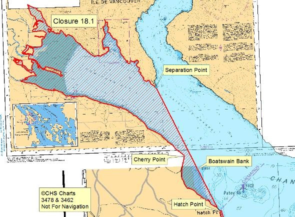
| 18.1 Cowichan Bay, Genoa Bay, Boatswain Bank | 18.1.png | The waters and intertidal foreshore of Cowichan Bay, including Genoa Bay and Boatswain Bank, lying inside a line drawn from Separation Point to Hatch Point. [NAD83] |
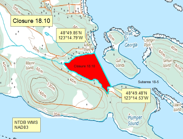
| 18.10 Horton Bay, Mayne Island | 18.10.png | "The waters and intertidal foreshore of Horton Bay, Mayne Island, inside a line drawn from Aitken Point at 48°49.85' north latitude and 123°14.79' west longitude, thence southeasterly to a point on land at 48°49.48' north latitude and 123°14.53' west longitude located east of the public dock. [NAD83] |
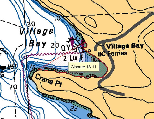
| 18.11 Village Bay, Mayne Island | 18.11.png | The intertidal foreshore of Village Bay, Mayne Island, lying inside a line drawn from a point on land 125 m north of the ferry dock to Crane Point. [NAD83] |
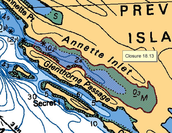
| 18.13 Annette Inlet, Prevost Island | 18.13.png | The waters and intertidal foreshore of Annette Inlet, Prevost Island, lying inside a line drawn across the narrowest point at the west end of the inlet. [NAD83] |
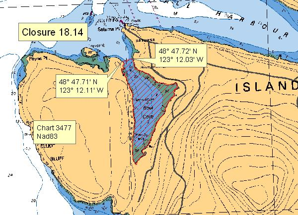
| 18.14 Boot Cove, Saturna Island | 18.14.png | The waters and intertidal foreshore of Boot Cove, lying inside of a line from a point on land at 48°47.71' north latitude and 123°12.11' west longitude, thence northeasterly to a point on land at 48°47.72' north latitude and 123°12.03' west longitude. [NAD83] |
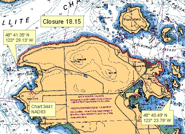
| 18.15 Northeast Saanich Peninsula | 18.15.png | The intertidal foreshore of Saanich Peninsula, lying between Curteis Point at 48°40.49' north latitude and 123°23.79' west longitude and Moses Point at 48°41.35' north latitude and 123°29.13' west longitude, which lies at the eastern boundary of the beach access road at the foot of Seabreeze Road. [NAD 83] |
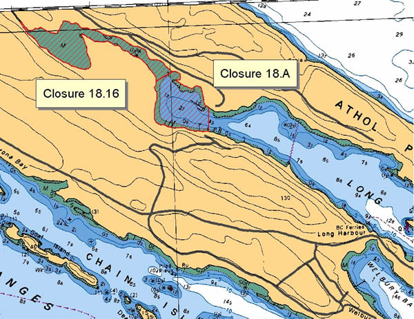
| 18.16 Long Harbour, Saltspring Island | 18.16.png | The waters and intertidal foreshore at the head of Long Harbour, Saltspring Island, lying inside a line drawn from the north side at 48°51.82' north latitude and 123°27.91' west longitude to the opposite shore at 48°51.77' north latitude and 123°28.00' west longitude. [NAD 83]. |
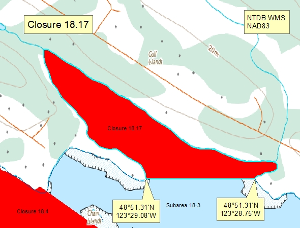
| 18.17 - Madrona Bay, Saltspring Island | 18.17.png | The waters and intertidal foreshore of Madrona Bay, Saltspring Island, lying north of a line drawn from a point of land at 48°51.31' north latitude and 123°29.08' west longitude due east to a point of land at 48°51.31' north latitude and 123°28.75' west longitude. [NAD83] |
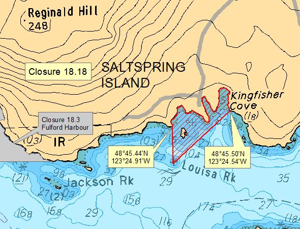
| 18.18 Unnamed bays E of Fulford Harbour, Saltspring Is. | 18.18.png | The waters and intertidal foreshore of the three unnamed bays east of Fulford Harbour, Saltspring Island, lying inside a line drawn from the western headland at 48°45.45' north latitude and 123°24.85' west longitude thence due south to Louisa Rock, thence on a true bearing of 50° to the northeasterly headland at 48°45.50' north latitude and 123°24.45' west longitude. [NAD 83]. |
| 18.20 Selby Cove, Prevost Island | 18.20.png | The waters and intertidal foreshore of Selby Cove, Prevost Island, lying inside a line drawn across the entrance to the cove. [NAD83] |
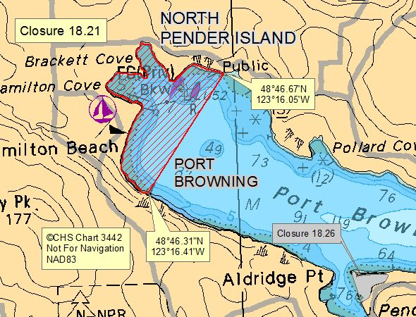
| 18.21 Port Browning, North Pender Island | 18.21.png | The waters and intertidal foreshore at the head of Port Browning, North Pender Island, inside a line drawn from the public wharf on the northern shore of Port Browning at 48°46.70' north latitude and 123°15.95' west longitude, thence southwesterly to the edge of the rocky shoal at 48°46.30' north latitude and 123°16.35' west longitude. [NAD 27]. |
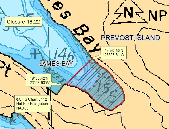
| 18.22 James Bay, Prevost Island | 18.22.png | The waters and intertidal foreshore of James Bay, Prevost Island, from a point of land on the south shore at 48°50.43' north latitude and 123°23.85' west longitude, thence northeasterly to the north shore at 48°50.50' north latitude and 123°23.72' west longitude. [NAD 83]. |
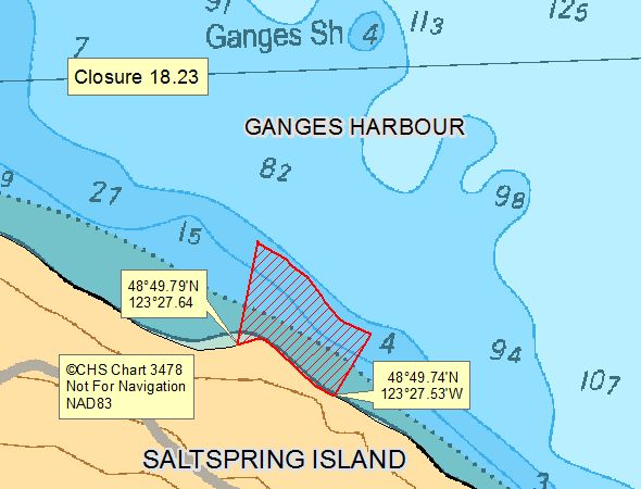
| 18.23 1.4 km From Walker Spit, Ganges Hbr. Saltspring Is | 18.23.png | The waters and intertidal foreshore on the southern shore of Ganges Harbour, Saltspring Island, from an abandoned wharf at 48°49.78' north latitude and 123°27.65' west longitude, thence approximately 150 meters eastward to 48°49.75' north latitude and 123°27.53' west longitude. [NAD83] |
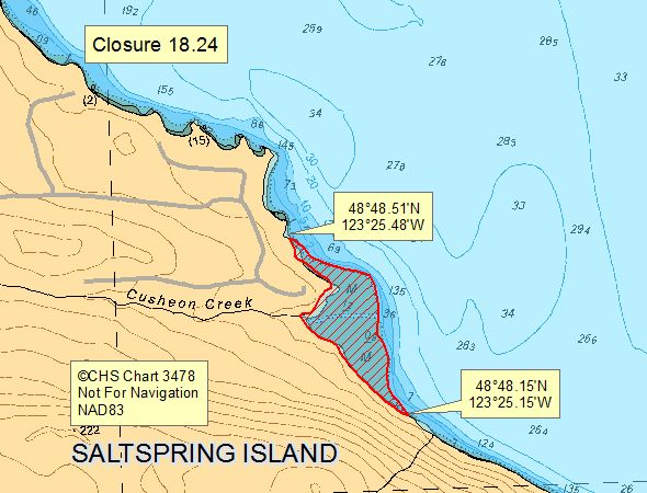
| 18.24 Cusheon Creek, Saltspring island | 18.24.png | The intertidal foreshore of Cusheon Creek , lying between a point on land northwesterly of Cusheon Creek at 48°48.51' north latitude and 123°25.44' west longitude, and a point on land southeasterly of Cusheon Creek at 48°48.17' north latitude and 123°25.15' west longitude. [NAD83] |
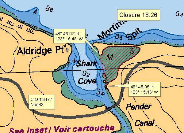
| 18.26 Shark Cove | 18.26.png | The waters and intertidal foreshore of Shark Cove, inside of a line from a southerly point on land at 48°45.95' north latitude and 123°15.46' west longitude, thence northerly to a point on land near the end of Mortimer Spit at 48°46.02' north latitude and 123°15.48' west longitude. [NAD83] |
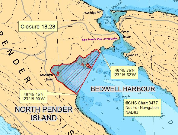
| 18.28 Bedwell Harbour, North Pender Island | 18.28.png | The waters and intertidal foreshore at the head of Bedwell Bay, North Pender Island, lying inside of a line from a point of land at 48°45.76' north latitude and 123°15.62' west longitude thence southerly to a point of land at 48°45.46' north latitude and 123°15.90' west longitude. [NAD83] |
| 18.29 Dinner Bay, Mayne Island | 18.29.png | The waters and intertidal foreshore of Dinner Bay lying east of a line drawn from a point of land on Mayne Island at 48°50.23' north latitude and 123°19.42' west longitude, thence southwest to a point on land on Mayne Island at 48°50.09' north latitude and 123°19.59' west longitude. [NAD83] |
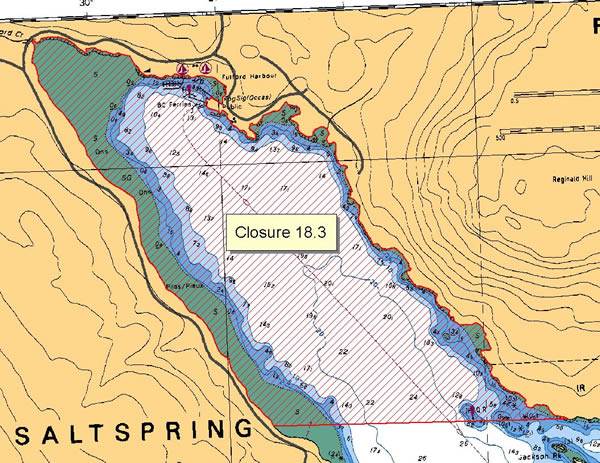
| 18.3 Fulford Harbour, Saltspring Island | 18.3.png | The waters and intertidal foreshore of Fulford Harbour, Saltspring Island, lying inside a line drawn in a due east-west direction through the quick-flashing red light on the southeast side of the harbour. [NAD83] |
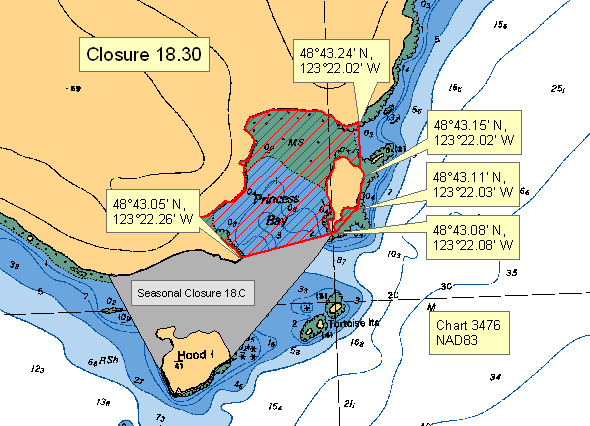
| 18.30 Princess Bay, Portland Island | 18.30.png | The waters and intertidal foreshore of Princess Bay located inside a line drawn from a point of land on Portland Island at 48°43.05 north latitude and 123°22.26' west longitude, thence northeast to the southernmost point of the unnamed island located north of the Tortoise Islets at 48°43.08' north latitude and 123°22.08' west longitude, thence northeast to a point of land at 48°43.11' north latitude and 123°22.03' west longitude, thence following the shoreline to the easternmost point of the unnamed island at 48°43.15' north latitude and 123°22.02' west longitude, thence due north to the shore of Portland Island at 48°43.24' north latitude and 123°22.02' west longitude. [NAD83] |
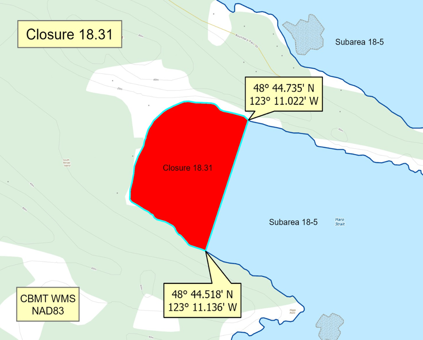
| 18.31 Camp Bay, South Pender Island | 18.31.png | The waters and intertidal foreshore of that portion of Subarea 18-5 inside a line that commences at 48°44.735'N, 123°11.022'W [Camp Bay, South Pender Island], then southwesterly to 48°44.518'N, 123°11.136'W [Camp Bay, South Pender Island], then following the shoreline northerly to the point of commencement. [NAD83] |
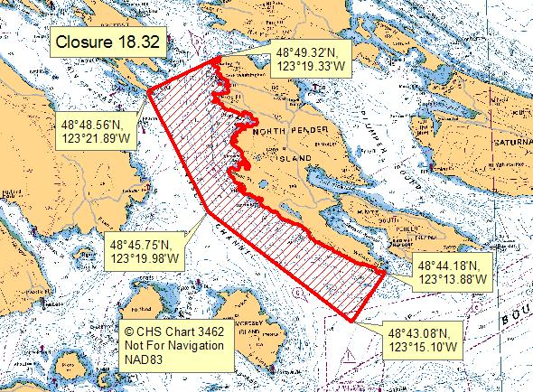
| 18.32 Stanley Point to Wallace Point, North Pender Island | 18.32.png | The waters and intertidal foreshore along the west side of North Pender Island inside a line drawn from a point on land at Stanley Point at 48°49.32' north latitude and 123°19.33' west longitude to Point Liddell, Prevost Island, at 48°48.56' north latitude and 123°21.89' west longitude, thence southeasterly to a point in water at 48°45.75' north latitude and 123°19.98' west longitude, thence southeasterly to a point in water at 48°43.08' north latitude and 123°15.10' west longitude, then northeasterly to Wallace Point at 48°44.18' north latitude and 123°13.88' west longitude, thence northwesterly following the shoreline of North Pender Island to the point of commencement. [NAD83] |
| 18.33 Burgoyne Bay, Saltspring Island | 18.33.png | The waters and intertidal foreshore of Burgoyne Bay lying inside a line drawn from a point on land at 48°47.66' north latitude and 123°31.31' west longitude southeasterly following the high water mark to a point on land at 48°47.46' north latitude and 123°31.08' west longitude, thence southwesterly to a point on land at 48°47.27' north latitude and 123°31.20' west longitude, thence northwesterly following the high water mark to a point on land at 48°47.37' north latitude and 123°31.63' west longitude, and thence northeasterly in a straight line to the point of commencement. [NAD 83] |
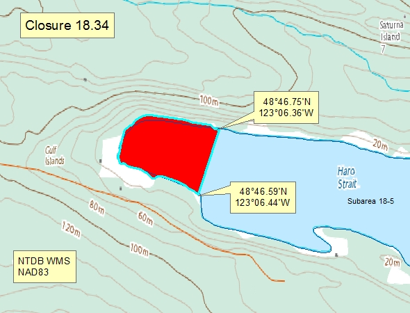
| 18.34 A portion of Narvaez Bay | 18.34.png | A portion of Narvaez Bay - The waters and intertidal foreshore of the head of Narvaez Bay lying west of a line drawn from a point on land at 48°46.75' north latitude and 123°06.36' west longitude thence southwesterly to a point on land at 48°46.59' north latitude and 123°06.44' west longitude. [NAD83] |
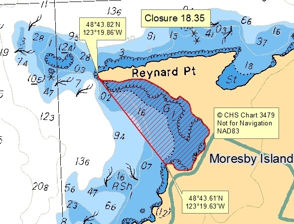
| 18.35 Head of the Bay, south of Reynard Point on northwest Moresby Island | 18.35.png | The waters and intertidal foreshore of the head of the bay south of Reynard Point on northwest Moresby Island lying east of a line drawn from a point of land at 48º43.82' north latitude and 123º19.86' west longitude thence southeasterly to a point of land at 48°43.61' north latitude and 123°19.63' west longitude. [NAD83] |
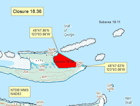
| 18.36 - East side of Tumbo Island | 18.36.png | The waters and intertidal foreshore of the unnamed bay on the east side of Tumbo Island, lying west of a line drawn from Savage Point at 48°47.86' north latitude and 123°03.66' west longitude thence southeasterly to Tumbo Point at 48°47.63' north latitude and 123°03.08' west longitude. [NAD83] |
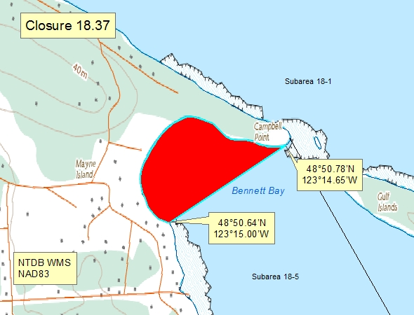
| 18.37 Bennett Bay, Mayne Island | 18.37.png | The waters and intertidal foreshore of Bennett Bay, Mayne Island, inside a line drawn from a point on land at 48°50.64', north latitude and 123°15.00' west longitude, thence northeasterly to a point of land at 48°50.78' north latitude and 123°14.65' west longitude. [NAD83] |
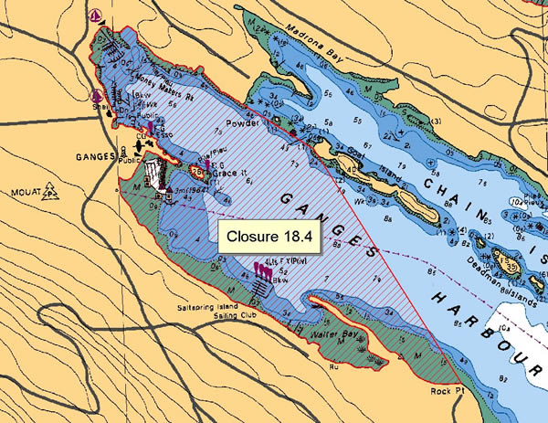
| 18.4 Ganges Harbour, Saltspring Island | 18.4.png | The waters and intertidal foreshore of Ganges Harbour, Saltspring Island, including Walter Bay lying inside a line drawn from the shore of Saltspring Island at 48°51.30 north latitude and 123°29.31' west longitude thence easterly to the west end of Goat Island at 48°51.17' north latitude and 123°29.00' west longitude and thence southerly to Rock Point at 48°50.40' north latitude and 123°28.40' west longitude. [NAD83] |
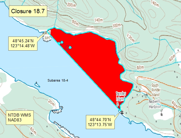
| 18.7 Bedwell Harbour, South Pender Island | 18.7.png | The waters and intertidal foreshore of Bedwell Harbour, lying inside of a line drawn across the harbour from a point on land on the south-western shore of South Pender Island located at 48°45.24' north latitude and 123°14.48' west longitude thence south-easterly to a point on land at 48°44.70' north latitude 123°13.75' west longitude. [NAD83] |
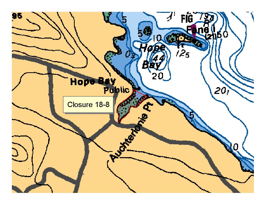
| 18.8 Hope Bay, North Pender Island | 18.8.png | The waters and intertidal foreshore of Hope Bay, north Pender Island, lying inside, that is south of, a line drawn from the land end of the government dock to Auchterlonie Point on the opposite side. [NAD83] |
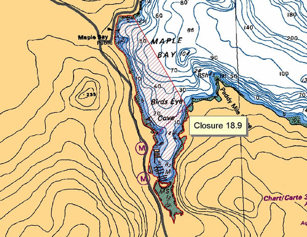
| 18.9 Maple Bay | 18.9.png | The waters and intertidal foreshore of Maple Bay, lying inside a line drawn from a point on the west shore located at 48°49.06 north latitude and 123°36.30' west longitude, thence southeasterly to the eastern shore at 48°48.25' north latitude and 123°35.72' west longitude [NAD 83 ]. |
| 18.A Long Harbour, Saltspring Island | 18.A.png | The waters and intertidal foreshore of that portion of Subarea 18-3 inside a line that commences at 48°51.394'N, 123°27.317'W [Long Harbour, Saltspring Island], then northeasterly to 48°51.810'N, 123°27.985'W [Long Harbour, Saltspring Island], then following the shoreline southeasterly to 48°51.625'N, 123°27.724'W [Long Harbour, Saltspring Island], then southerly to 48°51.546'N, 123°27.731'W [Long Harbour, Saltspring Island], then following the shoreline westerly to the point of commencement. [NAD83] |
| 18.B Reef Harbour, Tumbo Island | 18.B.png | The waters and intertidal foreshore of that portion of Subarea 18-11 inside a line that commences at 48°47.937'N, 123°05.340'W [Cabbage Island], then following the shoreline southeasterly to 48°47.938'N, 123°05.133'W [Cabbage Island], then easterly to 48°47.870'N, 123°04.546'W [Tumbo Island], then following the shoreline southerly to 48°47.756'N, 123°05.344'W [Tumbo Island], then northerly to the point of commencement. [NAD83] |
| 18.C Princess Bay, Portland Island | 18.C.png | The waters and intertidal foreshore of that portion of Subarea 18-6 inside a line that commences at 48°43.041'N, 123°22.525'W [Portland Island], then following the shoreline easterly to 48°43.054'N, 123°22.269'W [Portland Island], then easterly to 48°43.069'N, 123°22.083'W [Tortoise Islets], then southwesterly to 48°42.927'N, 123°22.294'W [Hood Island], then northerly to 48°42.920'N, 123°22.432'W [Hood Island], then northwesterly to the point of commencement. [NAD83] |
| 18.D Winter Cove | 18.D.png | The waters and intertidal foreshore of that portion of Subarea 18-5 inside the line that commences at 48°48.840'N, 123°12.213'W [Samuel Island], then following the shoreline easterly to 48°48.861'N, 123°11.353'W [Ralph Grey Point, Samuel Island], then southeasterly to 48°48.834'N, 123°11.338'W [Winter Point, Saturna Island], then following the shoreline southerly to 48°48.658'N, 123°12.208'W [Mikuni Point, Saturna Island], then northerly to the point of commencement. [NAD83] |
Last updated: 2026-06-09
| Area | Map | Area description |
|---|---|---|
| Coastwide | ||
| Pender Island Vessel Restricted Zone | Pender Island Vessel Restricted Zone | That portion of Subarea 18-4 west of Pender Island inside a line commencing at a point at 48°44.167'N and 123°13.917'W [Southeast Boundary (Wallace Point)] westerly to a point in water located at 48°44.153'N and 123°15.517'W [Southwest Boundary (Swanson Channel)], thence northwesterly to a point in water at 48°45.817'N and 123°19.300'W [Northwest Boundary (Swanson Channel)], thence northeasterly to point at 48°46.217'N and 123°18.867'W [Northeast Boundary (South of Thieves Bay)], and thence southeasterly following the shoreline back to the point of commencement. |
| Saturna Island Vessel Restricted Zone | Saturna Island Vessel Restricted Zone | Those portions of Subareas 18-5 and 18-11 off Saturna Island inside a line commencing on the shoreline of Saturna Island northwesterly at 48°47.150' north latitude and 123°02.733' west longitude [North Boundary East Point], then northwesterly to a point in water at 48°47.367' north latitude and 123°02.915' west longitude [Tumbo Channel], thence northeasterly to a point in water at 48°47.617' north latitude and 123°02.483' west longitude [Northwest Corner(East of Tumbo Point)], thence southeasterly to a point in water at 48°47.473' north latitude and 123°01.975 west longitude [Northeast Corner (Boiling Reef)], thence southwesterly to a point in water at 48°46.558' north latitude and 123°03.147' west longitude [Boundary Pass], thence southwesterly to a point in water at 48°46.333' north latitude and 123°03.805' west longitude [Southeast Corner], thence westerly to a point in water at 48°46.350' north latitude and 123°05.150' west longitude [Southwest Corner (Narvaez Bay)], thence due north to a point in water at 48°46.683'N and 123°05.150'W [Fiddler's Cove], and thence northeasterly along the shoreline back to the point of commencement. |
Last updated: 2026-06-09
Crab
Crab
- It is illegal to possess female Dungeness, King, Puget Sound King, Brown Box and Red Rock crabs. Female crabs must be released immediately. New
- Invasive European green crab
- Learn more about fishing for crab
Species regulations
Always check for restrictions.
| Species | Areas | Min size | Gear | Daily Limits | Status |
|---|---|---|---|---|---|
| Crab - Box | 18 | dip net, hand picking, hand picking while diving, ring net, trap | 1 | Open | |
| Crab - Dungeness | 18 | 165mm | dip net, hand picking, hand picking while diving, ring net, trap | 4 | Open |
| Crab - Dungeness and Red Rock combined | 18 | dip net, hand picking, hand picking while diving, ring net, trap | 4 | Open | |
| Crab - King | 18 | 0 | Closed | ||
| Crab - Puget Sound King | 18 | dip net, hand picking, hand picking while diving, ring net, trap | 1 | Open | |
| Crab - Red Rock | 18 | 115mm | dip net, hand picking, hand picking while diving, ring net, trap | 4 | Open |
| Crab - Shore | 18 | hand picking | 25 | Open | |
| Crab - other | 18 | dip net, hand picking, hand picking while diving, ring net, trap | 4 | Open |
Last updated: 2026-06-09
Restrictions
Always check for protected areas.
| Species | Areas | Restriction type | Restriction details |
|---|---|---|---|
| Shellfish | Pender Island Vessel Restricted Zone | Closed | No vessels or fishing (with some exceptions) in the Vessel Restricted Zones located in a portion of Subarea 18-4 and in portions of 18-5 and 18-11. Human-powered vessels (kayaks, canoes, etc.) may use a 20 m transit corridor along the shoreline. |
| Saturna Island Vessel Restricted Zone | Closed | No vessels or fishing (with some exceptions) in the Vessel Restricted Zones located in a portion of Subarea 18-4 and in portions of 18-5 and 18-11. Human-powered vessels (kayaks, canoes, etc.) may use a 20 m transit corridor along the shoreline. | |
| Crab | Burgoyne Bay | Dioxin Contamination (g/w) | 60 - Consumption of crab hepatopancreas in Burgoyne Bay, Saltspring Island should not exceed 60 g/week. |
| Maple Bay | Dioxin Contamination (g/w) | 125 - Consumption of crab hepatopancreas in Maple Bay should not exceed 125 g/week. | |
| Coastwide | Reminder | Keep navigation channels clear of buoys and lines. Any fishing gear that interferes with safe navigation can be removed under the Navigation Protection Act. | |
| Coastwide | Reminder | As per the British Columbia Sport Fishing Regulations, 1996 - Maximum of 2 ring nets, dip nets or traps or combination of these per fisher. Ensure gear is properly marked. Hand picking is permitted including by diving. No sharp-pointed instruments are permitted for harvesting crab. It is illegal to use snares in catching or attempting to catch crabs. | |
| Coastwide | Reminder | Rot Cord - As per the British Columbia Sport Fishing Regulations, 1996, all crab traps must have a section in the top or sidewall that has been secured by a single length of untreated cotton twine no greater than No. 120 (approximately 5 mm or 3/16 inch diameter). This twine is often referred to as rot cord. On deterioration this must produce a rectangular opening with a minimum size of 7 cm x 20 cm, or a square opening with a minimum size of 11 cm x 11 cm. This regulation is intended to ensure that if the trap is lost, the section secured by the cord will rot, allowing captive crabs to escape, and preventing the trap from continuing to fish. On traps with a rigid frame and a freely opening hinged lid, the trap lid must be secured by a single length of untreated cotton twine no greater than No. 120 so that the trap lid will open freely when the rot cord is broken. No other fastenings may impede the hinged lid of the trap from opening. | |
| Coastwide | Reminder | Crab, prawn and shrimp floats - As a Condition of Licence, the primary float attached to crab traps must be cylindrical in shape (includes bullet shaped) and a minimum of 27 cm in length and 12 cm in diameter; an optional secondary float may be used of any shape or size other than spherical. The primary float attached to prawn and shrimp traps must be spherical in shape and a minimum of 27 cm in diameter; an optional secondary float may be used of any shape or size other than cylindrical. | |
| Coastwide | Reminder | Floats must be made of a durable material and suitable for operation in marine waters. Floats/materials not suitable for use in marine waters are prohibited. | |
| Coastwide | Reminder | As per the British Columbia Sport Fishing Regulations, 1996 - Traps must be marked with a tag, float or buoy that has your name and telephone number on it. This includes traps tied to a boat or dock or fished from shore. If two traps are attached to one ground-line, it is sufficient to attach a tag, float or buoy that bears the operator's name and telephone number to one end of the ground-line. | |
| Coastwide | Reminder | As per the British Columbia Sport Fishing Regulations, 1996 - A line or rope attached to a trap must be submerged in such a manner that the line or rope does not come into contact with a person or a boat. | |
| Coastwide | Reminder | As a Condition of Licence, crab traps are required to have two unobstructed circular escape holes or rings, measuring a minimum of 105 mm in diameter. | |
| Coastwide | Reminder | When Open, the Possession Limit for crab is twice the Daily Limit. | |
| 18 | Time of Day Restrictions | Daylight hours - It is illegal to set or haul crab traps from one hour after sunset to one hour before sunrise. Overnight soaking of traps is allowed. | |
| Crab - Dungeness | Coastwide | Packaging and Transporting | In order to be accurately measured, the carapace of Dungeness crab that you catch must remain attached until the crab arrives at your residence or it is consumed. |
| Coastwide | Sex Restriction | It is prohibited to possess female Dungeness crab. | |
| Crab - Red Rock | Coastwide | Packaging and Transporting | In order to be accurately measured, the carapace of Red Rock crab that you catch must remain attached until the crab arrives at your residence or it is consumed. |
| Coastwide | Sex Restriction | It is prohibited to possess female Red Rock crab. | |
| Crab - King | Coastwide | Packaging and Transporting | In order to be accurately measured, the carapace of King crab that you catch must remain attached until the crab arrives at your residence or it is consumed. |
| Coastwide | Sex Restriction | It is prohibited to possess female King crab. | |
| Crab - Puget Sound King | Coastwide | Sex Restriction | As a Condition of Licence, it is prohibited to possess female Puget Sound King Crab. |
| Crab - Brown Box | Coastwide | Sex Restriction | As a Condition of Licence, it is prohibited to possess female Brown Box Crab. |
Last updated: 2026-06-09
Area descriptions
| Area | Map | Area description |
|---|---|---|
| Burgoyne Bay | Burgoyne Bay, Saltspring Island | |
| Coastwide | ||
| Maple Bay | Maple Bay | Maple Bay |
| Pender Island Vessel Restricted Zone | Pender Island Vessel Restricted Zone | That portion of Subarea 18-4 west of Pender Island inside a line commencing at a point at 48°44.167'N and 123°13.917'W [Southeast Boundary (Wallace Point)] westerly to a point in water located at 48°44.153'N and 123°15.517'W [Southwest Boundary (Swanson Channel)], thence northwesterly to a point in water at 48°45.817'N and 123°19.300'W [Northwest Boundary (Swanson Channel)], thence northeasterly to point at 48°46.217'N and 123°18.867'W [Northeast Boundary (South of Thieves Bay)], and thence southeasterly following the shoreline back to the point of commencement. |
| Saturna Island Vessel Restricted Zone | Saturna Island Vessel Restricted Zone | Those portions of Subareas 18-5 and 18-11 off Saturna Island inside a line commencing on the shoreline of Saturna Island northwesterly at 48°47.150' north latitude and 123°02.733' west longitude [North Boundary East Point], then northwesterly to a point in water at 48°47.367' north latitude and 123°02.915' west longitude [Tumbo Channel], thence northeasterly to a point in water at 48°47.617' north latitude and 123°02.483' west longitude [Northwest Corner(East of Tumbo Point)], thence southeasterly to a point in water at 48°47.473' north latitude and 123°01.975 west longitude [Northeast Corner (Boiling Reef)], thence southwesterly to a point in water at 48°46.558' north latitude and 123°03.147' west longitude [Boundary Pass], thence southwesterly to a point in water at 48°46.333' north latitude and 123°03.805' west longitude [Southeast Corner], thence westerly to a point in water at 48°46.350' north latitude and 123°05.150' west longitude [Southwest Corner (Narvaez Bay)], thence due north to a point in water at 48°46.683'N and 123°05.150'W [Fiddler's Cove], and thence northeasterly along the shoreline back to the point of commencement. |
Last updated: 2026-06-09
Other invertebrates
Other invertebrates
- Basic information about shellfish harvesting
- Seasonal recreational harvesting closures for prawn and shrimp
Species regulations
Always check for restrictions.
| Species | Areas | Gear | Daily Limits | Status |
|---|---|---|---|---|
| Abalone | 18 | 0 | Closed | |
| Barnacles - Giant | 18 | diving | 6 | Open |
| Barnacles - Goose | 18 | hand picking | 2kg | Open |
| Invertebrates - all other species | 18 | angling, dip net, hand digging, hand picking, hand picking while diving, hand picking while snorkeling, hand pump, ring net, spear fishing while diving, trap | 20 | Open |
| Limpet | 18 | hand picking | 75 | Open |
| Octopus | 18 | angling, hand picking, hand picking while diving, trap | 1 | Open |
| Sand Dollar | 18 | hand picking | 6 | Open |
| Sea Cucumber | 18 | hand picking, hand picking while diving | 12 | Open |
| Sea Star or Starfish | 18 | diving, hand picking | 6 | Open |
| Sea Urchin | 18 | hand picking, hand picking while diving | 12 | Open |
| Shellfish - all other species | 18 | angling, dip net, hand digging, hand picking, hand picking while diving, hand pump, ring net, spear fishing while diving, trap | 20 | Open |
| Shrimp - Ghost | 18 | hand digging, hand pump | 50 | Open |
| Shrimp including prawn | 18 | ring net, spear fishing while diving, trap | 125 | Open |
| Squid - Opal | 18 | cast net, jigging | 200 | Open |
| Squid - all other species | 18 | cast net, jigging | 20 | Open |
Last updated: 2026-06-09
Restrictions
Always check for protected areas.
| Species | Areas | Restriction type | Restriction details |
|---|---|---|---|
| Shellfish | Pender Island Vessel Restricted Zone | Closed | No vessels or fishing (with some exceptions) in the Vessel Restricted Zones located in a portion of Subarea 18-4 and in portions of 18-5 and 18-11. Human-powered vessels (kayaks, canoes, etc.) may use a 20 m transit corridor along the shoreline. |
| Saturna Island Vessel Restricted Zone | Closed | No vessels or fishing (with some exceptions) in the Vessel Restricted Zones located in a portion of Subarea 18-4 and in portions of 18-5 and 18-11. Human-powered vessels (kayaks, canoes, etc.) may use a 20 m transit corridor along the shoreline. | |
| Other Invertebrates | Coastwide | Reminder | When Open, the Possession Limit for other invertebrates is twice the Daily Limit. |
| Coastwide | Reminder | Rot Cord - As per the British Columbia Sport Fishing Regulations, 1996, all open mesh octopus traps and shrimp/prawn traps must have a section in the top or sidewall that has been secured by a single length of untreated cotton twine no greater than No. 120 (approximately 5 mm or 3/16 inch diameter). This twine is often referred to as rot cord. On deterioration this must produce a rectangular opening with a minimum size of 7 cm x 20 cm, or a square opening with a minimum size of 11 cm x 11 cm. This regulation is intended to ensure that if the trap is lost, the section secured by the cord will rot, allowing captive crabs to escape, and preventing the trap from continuing to fish. On traps with a rigid frame and a freely opening hinged lid the trap lid must be secured by a single length of untreated cotton twine no greater than No. 120 so that the trap lid will open freely when the rot cord is broken. No other fastenings may impede the hinged lid of the trap from opening. | |
| Coastwide | Reminder | As per the British Columbia Sport Fishing Regulations, 1996 - Traps must be marked with a tag, float or buoy that has your name and telephone number on it. This includes traps tied to a boat or dock or fished from shore. If two traps are attached to one ground-line, it is sufficient to attach a tag, float or buoy that bears the operator's name and telephone number to one end of the ground-line. | |
| Coastwide | Reminder | As per the British Columbia Sport Fishing Regulations, 1996 - A line or rope attached to a trap must be submerged in such a manner that the line or rope does not come into contact with a person or a boat. | |
| Coastwide | Reminder | Floats must be made of a durable material and suitable for operation in marine waters. Floats/materials not suitable for use in marine waters are prohibited. | |
| Octopus | Coastwide | Reminder | The use of sharp pointed instruments or chemicals is prohibited. |
| Shrimp including prawn | Coastwide | Reminder | Spot Prawns (Pandalus platyceros) with eggs - No person shall retain prawns carrying eggs, or remove eggs from the underside of prawns carrying eggs. All prawns carrying eggs externally on the underside of the tail shall be returned to the water immediately and in the manner that causes the least harm. |
| Coastwide | Reminder | As per the British Columbia Sport Fishing Regulations, 1996 - Maximum 4 traps or ring nets or combination of these per fisher. | |
| Coastwide | Reminder | Crab, prawn and shrimp floats - As a Condition of Licence, the primary float attached to crab traps must be cylindrical in shape (includes bullet shaped) and a minimum of 27 cm in length and 12 cm in diameter; an optional secondary float may be used of any shape or size other than spherical. The primary float attached to prawn and shrimp traps must be spherical in shape and a minimum of 27 cm in diameter; an optional secondary float may be used of any shape or size other than cylindrical. |
Last updated: 2026-06-09
Area descriptions
| Area | Map | Area description |
|---|---|---|
| Coastwide | ||
| Pender Island Vessel Restricted Zone | Pender Island Vessel Restricted Zone | That portion of Subarea 18-4 west of Pender Island inside a line commencing at a point at 48°44.167'N and 123°13.917'W [Southeast Boundary (Wallace Point)] westerly to a point in water located at 48°44.153'N and 123°15.517'W [Southwest Boundary (Swanson Channel)], thence northwesterly to a point in water at 48°45.817'N and 123°19.300'W [Northwest Boundary (Swanson Channel)], thence northeasterly to point at 48°46.217'N and 123°18.867'W [Northeast Boundary (South of Thieves Bay)], and thence southeasterly following the shoreline back to the point of commencement. |
| Saturna Island Vessel Restricted Zone | Saturna Island Vessel Restricted Zone | Those portions of Subareas 18-5 and 18-11 off Saturna Island inside a line commencing on the shoreline of Saturna Island northwesterly at 48°47.150' north latitude and 123°02.733' west longitude [North Boundary East Point], then northwesterly to a point in water at 48°47.367' north latitude and 123°02.915' west longitude [Tumbo Channel], thence northeasterly to a point in water at 48°47.617' north latitude and 123°02.483' west longitude [Northwest Corner(East of Tumbo Point)], thence southeasterly to a point in water at 48°47.473' north latitude and 123°01.975 west longitude [Northeast Corner (Boiling Reef)], thence southwesterly to a point in water at 48°46.558' north latitude and 123°03.147' west longitude [Boundary Pass], thence southwesterly to a point in water at 48°46.333' north latitude and 123°03.805' west longitude [Southeast Corner], thence westerly to a point in water at 48°46.350' north latitude and 123°05.150' west longitude [Southwest Corner (Narvaez Bay)], thence due north to a point in water at 48°46.683'N and 123°05.150'W [Fiddler's Cove], and thence northeasterly along the shoreline back to the point of commencement. |
Last updated: 2026-06-09
Protected areas
Protected areas
Learn about permanent restrictions that are in effect:
Find detailed maps and coordinates for protected areas in the Canadian Pacific
Learn about rules you need to follow to protect Southern Resident killer whales
| Area | Type | Closure name |
|---|---|---|
| 18-1 | Rockfish Conservation Area | Bell Chain Islets |
| Mayne Island North | ||
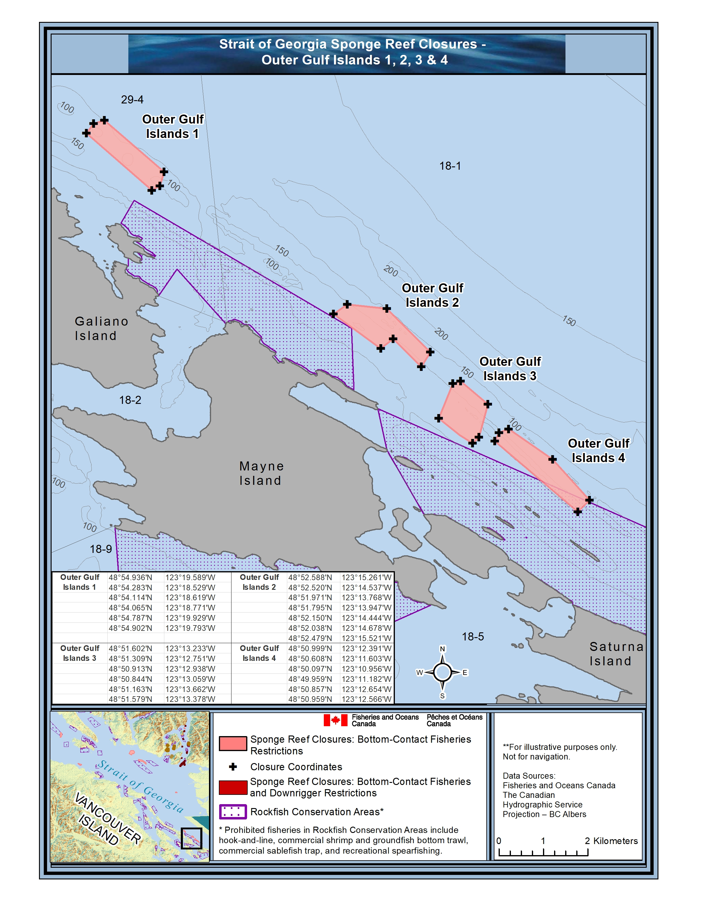
| Glass Sponge Reef | Outer Gulf Islands 1 | |
| Outer Gulf Islands 2 | ||
| Outer Gulf Islands 3 | ||
| Outer Gulf Islands 4 | ||
| 18-2 | Rockfish Conservation Area | Prevost Island North |
| 18-3 | Rockfish Conservation Area | Prevost Island North |
| 18-4 | Rockfish Conservation Area | Bedwell Harbour |
| 18-5 | Rockfish Conservation Area | Navy Channel |
| South Saturna | ||
| 18-6 | Rockfish Conservation Area | Brethour, Domville, Forrest, Gooch Islands |
| Coal Island | ||
| Portland Island | ||
| 18-7 | Rockfish Conservation Area | Burgoyne Bay |
| Maple Bay | ||
| Patey Rock | ||
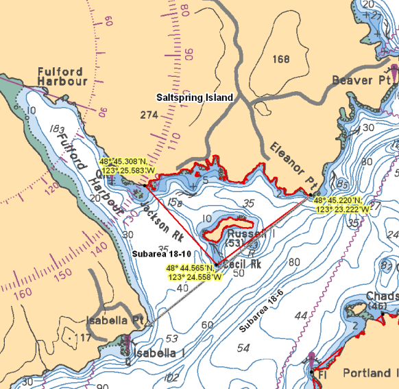
| 18-10 | Rockfish Conservation Area | Russell Island |
| 18-11 | Rockfish Conservation Area | Bell Chain Islets |
Last updated: 2026-06-09
Area descriptions
| Area | Map | Area description |
|---|---|---|
| Bedwell Harbour | Bedwell Harbour | In Subarea 18-4 that portion of Bedwell Harbour that lies northerly of a line: from 48°44.200'N 123°13.900'W Wallace Point to 48°43.950'N 123°12.483'W Tilly Point and southeasterly of a line: from 48°45.250'N 123°14.500'W South Pender Island to 48°44.900'N 123°14.750'W North Pender Island. |
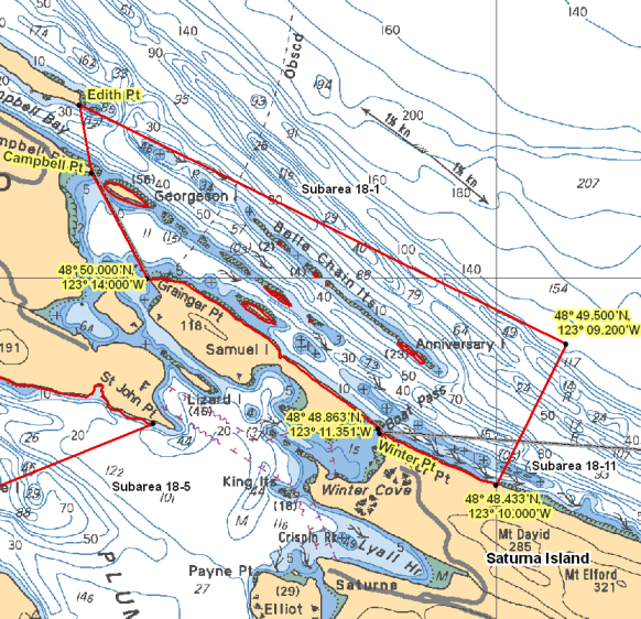
| Bell Chain Islets | Bell Chain Islets | Those portions of Subareas 18-1 and 18-11 that lie inside a line that: begins at 48°51.309'N 123°14.775'W Edith Point then to 48°49.500'N 123°09.200'W in water then to 48°48.433'N 123°10.000'W Saturna Island then following the northerly shoreline of Saturna Island to 48°48.827'N 123°11.333'W Winter Point then to 48°48.863'N 123°11.351'W Ralph Grey Point then following the northerly shoreline of Samuel Island to 48°50.000'N 123°14.000'W Grainger Point then to 48°50.797'N 123°14.636'W Campbell Point then to the beginning point. |
| Brethour, Domville, Forrest, Gooch Islands | Brethour, Domville, Forrest, Gooch Islands | Those waters of Subareas 18-6 and 19-5 that lie inside a line that: begins at 48°41.650'N 123°19.978'W Imrie Island then to 48°41.088'N 123°17.622'W Arachne Reef Light then following the boundary line between Subarea 18-6 and 19-5 to the intersection with the International Boundary between the United States and Canada, then following the International Boundary in a southerly direction to the intersection with the parallel passing through 48°39.800' north latitude, then to 48°39.738'N 123°16.551'W Tom Point then to 48°38.989'N 123°18.081'W South Cod Reef Buoy then to 48°39.400'N 123°19.645'W Forrest Island then following the northerly shoreline of Forrest Island to 48°39.963'N 123°20.467'W Forrest Island then to 48°40.865'N 123°20.410'W Greig Island Daybeacon then to the beginning point. |
| Burgoyne Bay | Those waters of Subarea 18-7 that lie easterly of a line: from 48°47.263'N 123°33.243'W Bold Bluff Point to 48°48.417'N 123°32.813'W shoreline. | |
| Coal Island | Coal Island | Those waters of Subareas 18-6 and 19-5 that lie inside a line that: begins at 48°41.278'N 123°24.124'W Swartz Head then to 48°41.474'N 123°23.289'W Fir Cone Point Light then following the westerly shoreline of Coal Island to 48°40.753'N 123°22.626'W west of Kamai Point then to 48°40.232'N 123°22.669'W Little Shell Island then to 48°40.047'N 123°23.859'W Armstrong Point then westerly following the shoreline to 48°40.179'N 123°24.273'W Tsehum Harbour Breakwater then to 48°40.478'N 123°23.804'W Curteis Point then northerly following the shoreline to the beginning point. |
| Maple Bay | Maple Bay | Those waters of Maple Bay in Subarea 18-7 that lie westerly of a line: from 48°49.314'N 123°35.195'W Arbutus Point to 48°48.504'N 123°35.333'W Paddy Mile Stone. |
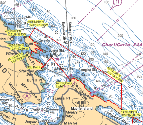
| Mayne Island North | Mayne Island North | Those portions of Subareas 18-1 and 29-4 that lie inside a line that: begins at 48°53.163'N 123°19.250'W Cain Point then true north to 48°53.259'N 123°19.250'W Gossip Island then following the easterly shoreline of Gossip Island to 48°53.671'N 123°19.367'W Gossip Island then to 48°53.950'N 123°19.100'W in water then to 48°52.300'N 123°15.200'W in water then true south to 48°51.550'N 123°15.200'W Mayne Island, near Edith Point then northwesterly following the Mayne Island shoreline to 48°52.398'N 123°17.487'W Active Pass Light then to 48°53.099'N 123°18.362'W Gossip Shoals Light and Bell Buoy U47 then to 48°52.778'N 123°18.724'W Rip Point then northwesterly following the shoreline of Galiano Island to the beginning point. |
| Navy Channel | Navy Channel | That portion of Subarea 18-5 that lies easterly of a line: from 48°50.000'N 123°19.678'W Dinner Point to 48°49.141'N 123°19.632'W Stanley Point and northwesterly of a line: from 48°48.900'N 123°13.933'W west of St. John Point to 48°48.200'N 123°16.554'W north shore of Hope Bay |
| Outer Gulf Islands 1 | Outer Gulf Islands 1 | Those portions of Subareas 18-1 and 29-4 that lie inside a line that: begins at 48°54.936'N 123°19.589'W then southerly to 48°54.283'N 123°18.529'W then to 48°54.114'N 123°18.619'W then to 48°54.065'N 123°18.771'W then to 48°54.787'N 123°19.929'W then to 48°54.902'N 123°19.793'W then to the beginning point. |
| Outer Gulf Islands 2 | Outer Gulf Islands 2 | Those portions of Subareas 18-1 and 29-4 that lie inside a line that: begins at 48°52.588'N 123°15.261'W then easterly to 48°52.520'N 123°14.537'W then to 48°51.971'N 123°13.768'W then to 48°51.795'N 123°13.947'W then to 48°52.150'N 123°14.444'W then to 48°52.038'N 123°14.678'W then to 48°52.479'N 123°15.521'W then to the beginning point. |
| Outer Gulf Islands 3 | Outer Gulf Islands 3 | Those portions of Subareas 18-1 and 29-4 that lie inside a line that: begins at 48°51.602'N 123°13.233'W then southerly to 48°51.309'N 123°12.751'W then to 48°50.913'N 123°12.938'W then to 48°50.844'N 123°13.059'W then to 48°51.163'N 123°13.662'W then to 48°51.579'N 123°13.378'W then to the beginning point. |
| Outer Gulf Islands 4 | Outer Gulf Islands 4 | Those portions of Subareas 18-1 and 29-4 that lie inside a line that: begins at 48°50.999'N 123°12.391'W then southerly to 48°50.608'N 123°11.603'W then to 48°50.097'N 123°10.956'W then to 48°49.959'N 123°11.182'W then to 48°50.857'N 123°12.654'W then to 48°50.959'N 123°12.566'W then to the beginning point. |
| Patey Rock | Patey Rock | Those waters of Subarea 18-7 that lie inside a line that: begins at 48°42.250'N 123°31.500'W in water then true east to 48°42.250'N 123°30.500'W in water then true south to 48°41.850'N 123°30.500'W in water then true west to 48°41.850'N 123°31.500'W in water then to the beginning point. |
| Portland Island | Portland Island | That portion of Subarea 18-6 that lies inside a line that: begins at 48°44.100'N 123°22.200'W northern tip of Portland Island then to 48°44.012'N 123°20.404'W Canoe Rock Light then to 48°43.339'N 123°21.045'W Pellow Islets Light Buoy U15 then to 48°42.639'N 123°22.962'W Celia Reef Light Buoy U14 then to 48°43.559'N 123°23.215'W Kanaka Bluff Light then following the northwesterly shoreline of Portland Island to the beginning point. |
| Prevost Island North | Prevost Island North | Those waters of Subareas 17-1, 18-2 and 18-3 that lie inside a line that: begins at 48°51.000'N 123°25.423'W Athol Peninsula then to 48°51.623'N 123°23.465'W Ben Mohr Light Buoy then to 48°49.949'N 123°21.550'W near Portlock Point then following the northwesterly shoreline of Prevost Island to 48°48.544'N 123°21.940'W Point Liddell then to 48°48.618'N 123°22.902'W Acland Islands Light Buoy then to 48°49.854'N 123°25.033'W Horda Shoals Light Buoy then to 48°50.552'N 123°25.175'W Nose Point Light then following the shoreline of Athol Peninsula to the beginning point. |
| Russell Island | Russell Island | Those waters of Subarea 18-10 that lie inside a line that: begins at 48°45.220'N 123°23.222'W Eleanor Point then to 48°44.565'N 123°24.558'W Cecil Rock then to 48°45.308'N 123°25.583'W near Jackson Rock then easterly following the shoreline to the beginning point. |
| South Saturna | South Saturna | That portion of Subarea 18-5 that lies inside a line that: begins at 48°46.842'N 123°04.846'W near Fiddlers Cove then to 48°44.750'N 123°05.000'W in water then to 48°43.462'N 123°09.600'W in water then to 48°44.139'N 123°11.029'W Gowlland Point Light then following the northerly shoreline of South Pender Island to 48°45.330'N 123°12.200'W north of Little Bay then to 48°46.473'N 123°12.154'W Croker Point Light then following the southerly shoreline of Saturna Island to the beginning point. |
Last updated: 2026-06-09
- Date modified: