
BC tidal areas 2, 102, 130 and 142 - Haida Gwaii: Recreational fishing limits, openings and closures
Licence holders must follow fishing regulations unless otherwise specified in the Conditions of Licence.
How to follow the rules
- Make sure you have a current BC Tidal Waters sport fishing licence with you at all times. Are you using the FishingBC App for electronic licensing and catch recording? Learn more.
- Check the Area map. You need to know the location (subarea) where you plan to fish.
- Check the species regulations tables for fishing opportunities and basic regulations.
- Check the restrictions tables for special exceptions and more detailed regulations. Make sure you know the:
- Daily limit: The maximum number of a given fish species that a person is allowed to keep in one day.
- Possession limit: The maximum number of fish you can have in your possession at any given time, except for what is at your ordinary residence. The possession limit for most species is double the daily limit.
- Annual limit: The total amount of fish of a certain species that may be caught and retained during the course of a fishing year which starts on April 1 and ends the following March 31. Check "Restrictions" under each section for annual limits by species.
- Get to know the locations of protected areas. Permanent fishing restrictions are in effect in these areas to protect fish and fish habitat.
- Unless otherwise specified, fishing opportunities and closures end at 23:59 hrs on the close-date shown.
Related links
Area map
Area maps
This map is for information only and should not be used for fishing, navigation or other purposes.
For a written description of Areas please see the Pacific Fishery Management Area Regulations 2007.
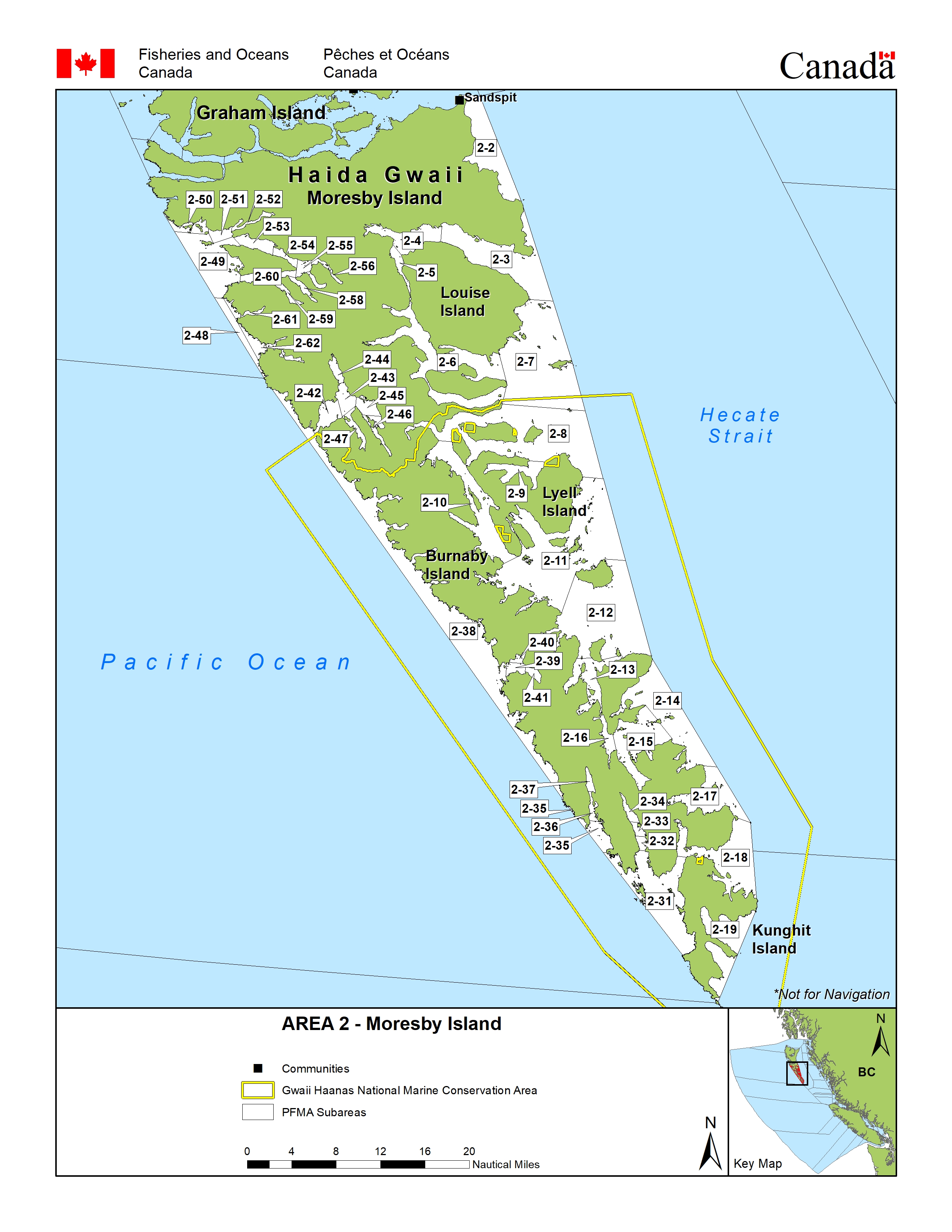
Area 2 - Graham Island: Download a printable PDF version of this map.
Area 2 - Moresby Island: Download a printable PDF version of this map.
Area 102: Download a printable PDF version of this map.
Area 130: Download a printable PDF version of this map.
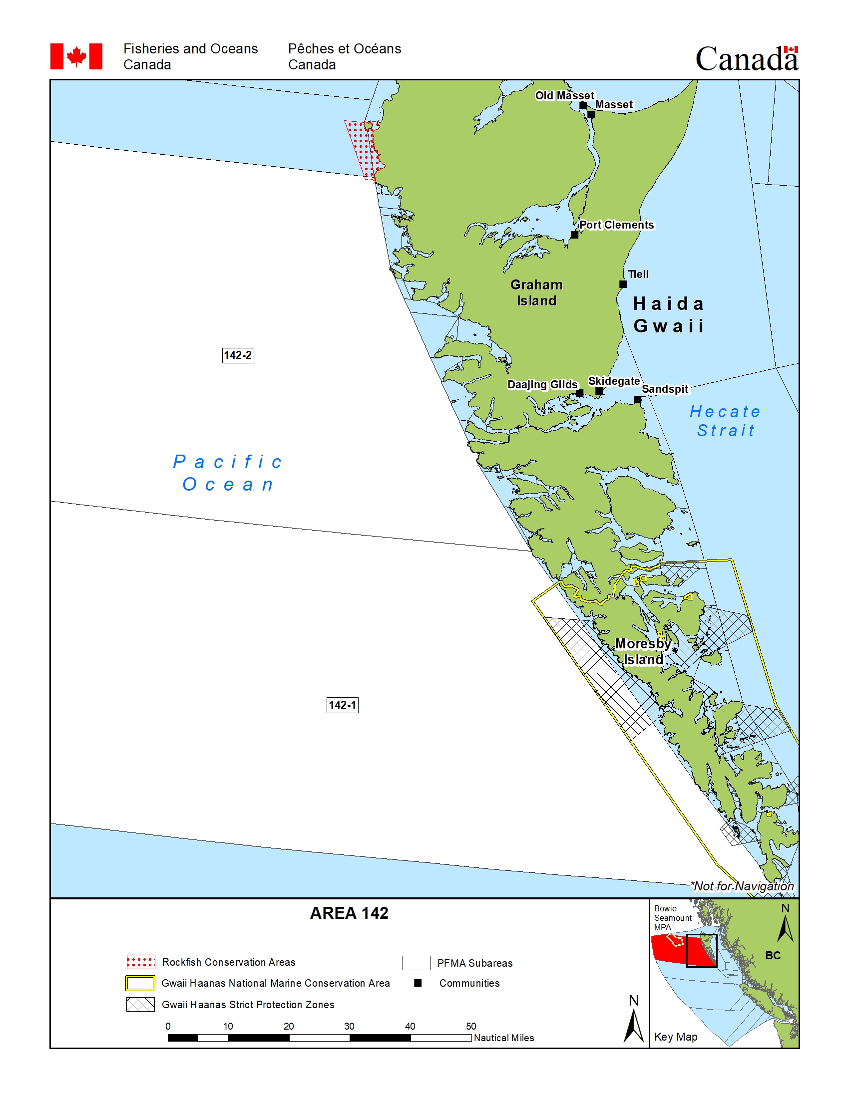
Area 142: Download a printable PDF version of this map.
Click thumbnail to enlarge image.


Salmon
Salmon
- You must have a valid a salmon conservation stamp on your BC Tidal Waters sport fishing licence if you plan to retain salmon.
- You must immediately and permanently record all retained chinook salmon on your paper licence, your NRLS catch log or your NRLS-linked FishingBC app catch log.
- Learn more about fishing for salmon
Species regulations
Always check for restrictions.
| Species | Areas | Min size | Gear | Daily Limits | Status |
|---|---|---|---|---|---|
| Chinook salmon (hatchery and wild combined) | 102-2,102-3 and 130 | 45cm | barbless hook and line | 2 | Open |
| 2,102-1,142 | 45cm | barbless hook and line | 1 | Open | |
| Chum salmon | 2,102,130,142 | 30cm | barbless hook and line | 4 | Open |
| Coho salmon (hatchery and wild combined) | 2,102,130,142 | 30cm | barbless hook and line | 4 | Open |
| Pink salmon | 2,102,130,142 | 30cm | barbless hook and line | 4 | Open |
| Sockeye salmon | 2,102,130,142 | 30cm | barbless hook and line | 4 | Open |
Last updated: 2026-06-09
Restrictions
Always check for protected areas.
| Species | Areas | Restriction type | Restriction details |
|---|---|---|---|
| Finfish | X̲aana K̲aahlii (Skidegate Inlet) Marine Refuge | Shore Fishing Only | Only shore-based angling defined as occurring in the waters inside and shoreward of the 2m depth contour measured below the chart datum (0 tide) within the proposed marine refuge is permitted. |
| Salmon | Copper River estuary / Pallant Creek estuary | Gear Restriction | You are not allowed to harvest using the following gears and methods:
|
| Tidal waters of all streams on Haida Gwaii | Gear Restriction | You are not allowed to harvest using the following gears and methods:
|
|
| Coastwide | Daily Limit Pieces | 4 - The daily limit for all species of Pacific salmon from tidal and fresh waters combined is four. Individual species limits also apply. | |
| 2,102,130,142 | Gear Restriction | You are not allowed to harvest using the following gears and methods:
|
|
| Coastwide | Reminder | When Open, the Possession Limit for salmon is twice the Daily Limit. | |
| Coastwide | Reminder | Hatchery (marked) salmon - Chinook and coho salmon with a healed scar in place of the adipose fin. | |
| Chinook salmon (hatchery and wild combined) | Coastwide | Annual Limit Pieces | 10 - The coastwide total annual limit for chinook salmon is 10 from all tidal waters that are open to chinook retention. |
| Coastwide | Reminder | Keeping your chinook salmon? You must permanently record all retained chinook salmon (head-on length) on your Tidal Waters Sport Fishing Licence. The licence holder may alternatively record retained catch immediately in an electronic licence held in an approved third-party application linked to their National Recreational Licensing System (NRLS) account, or if mobile internet access is immediately available, directly in their NRLS account. The licence holder shall ensure that all mandatory catch records for the current licence year are produced, either on the licence (paper or electronic), or from the licence holder's NRLS account at the time of inspection. | |
| Coho salmon (hatchery and wild combined) | Tidal waters of all streams on Haida Gwaii | Daily Limit Pieces | 2 |
| Pink salmon | Tidal waters of the Tlell River | Daily Limit Pieces | 0 |
| Sockeye salmon | Fairfax Inlet | Daily Limit Pieces | 0 |
| Skidegate Inlet | Daily Limit Pieces | 0 |
Last updated: 2026-06-09
Area descriptions
| Area | Map | Area description |
|---|---|---|
| Coastwide | ||
| Copper River estuary / Pallant Creek estuary | That portion of Subarea 2-2 shoreward of a straight line between two boundary signs located on either side of Copper River estuary; and that portion of Subarea 2-4 shoreward of a straight line between two boundary signs located on either side of Pallant Creek estuary (in Area 2). | |
| Fairfax Inlet | The waters of Fairfax Inlet shoreward of a line from Magneson Point to Reid Point (in Area 2). | |
| Skidegate Inlet | The waters west of a line from Lawn Point to Gray Point (in Area 2). | |
| Tidal waters of all streams on Haida Gwaii | The tidal portion of all streams flowing into Areas 1, 2 and 102. | |
| Tidal waters of the Tlell River | That portion of Area 2 described as the Tidal waters of the Tlell River downstream of a white triangular fishing boundary sign located approximately 1 km upstream of the Highway #16 bridge. | |
| X̲aana K̲aahlii (Skidegate Inlet) Marine Refuge | X̲aana K̲aahlii (Skidegate Inlet) Marine Refuge | Tllgaduu G̲andlaay Sɢ̲aagiidaay (Slatechuk Creek): That portion of subarea 2-1 that lies inside a line commencing at 53° 13.649' N, 132° 13.500' W then southerly to a point on land at 53° 13.303' N, 132° 13.595' W then southerly to a point on land 53° 13.056' N, 132° 14.151' W then easterly to a point on land at 53° 13.129' N, 132° 14.603' W then northerly to the beginning point. Diina (Deena Creek): That portion of subarea 2-1 that lies inside a line commencing at 53° 09.415' N, 132° 06.870' W then south easterly to a point on land at 53° 09.105' N, 132° 05.650' W then westerly following the shoreline to 53° 09.246' N, 132° 07.064' W then northerly to a point in water at 53° 09.306' N, 132° 07.036' W then northerly to a point in water at 53° 09.381' N, 132° 06.947' W then northerly to the beginning point. Hlɢ̲aagilda Llnagaay Sɢ̲aagiidaay (Skidegate): That portion of subarea 2-1 that lies inside a line commencing at 53° 17.933' N, 131° 57.984' W then easterly to a point in water at 53° 17.887' N, 131° 57.517' W then southerly to a point in water at 53° 15.335' N, 131° 58.180' W then southerly to a point in water at 53° 14.616' N, 131° 58.830' W then north westerly to a point on land at 53° 14.856' N, 131° 59.749' W then northerly to the beginning point. |
_Marine_Refuge.png)
Last updated: 2026-06-09
Other finfish
Finfish other than salmon
- You must immediately and permanently record all retained halibut on your paper licence, your NRLS catch log or your NRLS-linked FishingBC app catch log.
- Check the Restrictions for the current possession limit for Pacific halibut
- Learn more about fishing for finfish
Species regulations
Always check for restrictions.
| Species | Areas | Min size | Gear | Daily Limits | Status |
|---|---|---|---|---|---|
| Codfish | 2,102,130,142 | angling, spear fishing while diving | 8 | Open | |
| Eulachon | 2,102,130,142 | 0kg | Closed | ||
| Finfish - all other species | 2,102,130,142 | angling, dip net, herring jig, herring rake, spear fishing while diving | 20 | Open | |
| Greenling | 2,102,130,142 | angling, spear fishing while diving | 3 | Open | |
| Halibut | 2,102,130,142 | angling, spear fishing while diving | 1 | Open | |
| Herring | 2,102,130,142 | cast net, dip net, herring jig, herring rake | 20kg | Open | |
| Lingcod | 2,102,130,142 | 65cm | angling, spear fishing while diving | 3 | Open |
| Mackerel | 2,102,130,142 | angling, dip net, herring jig, herring rake, spear fishing while diving | 100 | Open | |
| Northern Anchovy | 2,102,130,142 | cast net, dip net, herring jig, herring rake | 20kg | Open | |
| Pacific sand lance | 2,102,130,142 | cast net, dip net, herring jig, herring rake | 5kg | Open | |
| Pacific sardine | 2,102,130,142 | angling, dip net, herring jig, herring rake, spear fishing while diving | 100 | Open | |
| Rockfish - Yelloweye | 2,102,130,142 | angling, spear fishing while diving | 0 | Non Retention | |
| Rockfish - all species except Yelloweye | 2,102,130,142 | angling, spear fishing while diving | 3 | Open | |
| Sablefish | 2,102,130,142 | angling | 4 | Open | |
| Sculpin | 2,102,130,142 | angling | 8 | Open | |
| Shark - Basking | 2,102,130,142 | 0 | Closed | ||
| Shark - Blue | 2,102,130,142 | 0 | Closed | ||
| Shark - Brown Cat | 2,102,130,142 | 0 | Closed | ||
| Shark - Great White | 2,102,130,142 | 0 | Closed | ||
| Shark - Salmon | 2,102,130,142 | angling, spear fishing while diving | 1 | Open | |
| Shark - Sixgill | 2,102,130,142 | 0 | Closed | ||
| Shark - Tope | 2,102,130,142 | 0 | Closed | ||
| Shark - all other species | 2,102,130,142 | 0 | Closed | ||
| Skate | 2,102,130,142 | angling | 1 | Open | |
| Smelt | 2,102,130,142 | dip net, gill net | 20kg | Open | |
| Sole or Flounder | 2,102,130,142 | angling, spear fishing while diving | 8 | Open | |
| Spiny Dogfish | 2,102,130,142 | angling, spear fishing while diving | 0 | Non Retention | |
| Surfperch | 2,102,130,142 | angling | 8 | Open | |
| Tuna - Albacore | 2,102,130,142 | angling, spear fishing while diving | 20 | Open | |
| Tuna - Pacific bluefin | 2,102,130,142 | angling, spear fishing while diving | 20 | Open | |
| Tuna - all other species | 2,102,130,142 | angling, spear fishing while diving | 20 | Open | |
| White Sturgeon | 2,102,130,142 | angling | 0 | Non Retention | |
| Wolf Eel | 2,102,130,142 | angling | 0 | Non Retention |
| Species | Areas | Min size | Gear | Daily Limits | Status |
|---|---|---|---|---|---|
| Trout (hatchery and wild combined) | 2,102,130,142 | 30cm | angling | 2 Combined Total * Consisting of no more than:
|
Open |
Last updated: 2026-06-10
Restrictions
Always check for protected areas.
| Species | Areas | Restriction type | Restriction details |
|---|---|---|---|
| Finfish | X̲aana K̲aahlii (Skidegate Inlet) Marine Refuge | Shore Fishing Only | Only shore-based angling defined as occurring in the waters inside and shoreward of the 2m depth contour measured below the chart datum (0 tide) within the proposed marine refuge is permitted. |
| Other Finfish | Coastwide | Reminder | When Open, the Possession Limit for finfish other than salmon is twice the Daily Limit – except for Halibut (see Restrictions section). |
| Herring | Coastwide | Reminder | Harvesting of herring roe from marine plants or plants placed in the water for the purpose of harvesting herring roe is prohibited. |
| Eulachon | Coastwide | Closed | Due to conservation concerns the harvesting of eulachon is prohibited. |
| Codfish | Coastwide | Reminder | Species includes - Pacific cod, Pacific tomcod, pollock and hake but does not include lingcod. |
| Halibut | Coastwide | Reminder | As a Condition of Licence, no person shall catch and retain more than ten (10) Halibut in the aggregate from April 1, 2026 to March 31, 2027. No person shall retain a Halibut greater than 112 cm head-on length (85 cm pectoral length (head-off)). The possession limit is equal to the daily limit. Head-off measurements are made from the base of the pectoral fin at its most forward point to the extreme end of the middle of the tail. |
| Coastwide | Reminder | You must permanently record all retained Halibut (head-on length) on your Tidal Waters Sport Fishing Licence. The licence holder may alternatively record retained catch immediately in an electronic licence held in an approved third-party application linked to their National Recreational Licensing System (NRLS) account, or if mobile internet access is immediately available, directly in their NRLS account. The licence holder shall ensure that all mandatory catch records for the current licence year are produced, either on the licence (paper or electronic), or from the licence holder's NRLS account at the time of inspection. | |
| Lingcod | Coastwide | Reminder | The pectoral length (head -off) requirement for Lingcod is 53 cm. Pectoral length (head-off) measurements are made from the base of the pectoral fin at its most forward point to the extreme end of the middle of the tail. |
| Coastwide | Season Planning | For planning purposes only: For in-season requirements, please see current regulations/restrictions for specific areas, gear and individual species limits, and closures/exceptions. INSIDE WATERS - Generally open May 1 to September 30, for Areas 13 to 19 and Subareas 12-1 to 12-13, 12-15 to 12-48, 20-5 to 20-7 and 29-5. Closed year round - Area 28 and Subareas 29-1 to 29-4 and 29-6 to 29-17. OUTSIDE WATERS - Generally open April 1 to November 15, for Areas 1 to 10, 101 to 110, 130, 142, 11, 21 to 27, 111, 123 to 127, Subareas 12-14 and 20-1 to 20-4, and Area 121 (portion). | |
| Perch | Coastwide | Reminder | Includes kelp, shiner and pile perch, and all species of surf and sea perch. |
| Rockfish | Coastwide | Reminder | Anglers in vessels shall immediately return all rockfish that are not being retained to the water and to a similar depth from which they were caught by use of an inverted weighted barbless hook or other purpose-built descender device. |
| Coastwide | Season Planning | For planning purposes only: For in-season requirements, please see current regulations/restrictions for specific areas, gear and individual species limits, and closures/exceptions. INSIDE WATERS - Generally open May 1 to September 30, for Areas 13 to 19 and Subareas 12-1 to 12-13, 12-15 to 12-48, 20-5 to 20-7 and 29-5. Closed year round - Area 28 and Subareas 29-1 to 29-4 and 29-6 to 29-17. OUTSIDE WATERS - Generally Open April 1 to November 15, for Areas 1 to 10, 101 to 110, 130, 142, 11, 21 to 27, 111, 123 to 127, Subareas 12-14 and 20-1 to 20-4, and Area 121 (portion). | |
| Rockfish - all species except Yelloweye | 2,102,130,142 | Reminder | As a Condition of Licence, excluding Yelloweye, no person shall catch and retain in a day more than three (3) rockfish, only one (1) of which may be a Quillback Rockfish, a China Rockfish, or a Tiger Rockfish (Note: Not one of each species, but only one of the three). |
| Sculpin | Coastwide | Reminder | Cabezon is a species of sculpin; for daily and possession limits, please see the species regulations table above for sculpin. |
| Trout (hatchery and wild combined) | Tidal waters of the Tlell River | Daily Limit Pieces | 0 |
| Coastwide | Reminder | Note: (1) Trout - means Brook trout, Brown trout, Cutthroat trout, Dolly Varden, Lake trout, Rainbow trout, Steelhead, and includes Bull trout. (2) Steelhead - in waters where anadromous Rainbow trout are found, Steelhead means a Rainbow trout that is greater than 50cm in overall length. (3) Anadromous means migrating from the sea up rivers or streams to spawn. |
Last updated: 2026-06-10
Area descriptions
| Area | Map | Area description |
|---|---|---|
| Coastwide | ||
| Tidal waters of the Tlell River | That portion of Area 2 described as the Tidal waters of the Tlell River downstream of a white triangular fishing boundary sign located approximately 1 km upstream of the Highway #16 bridge. | |
| X̲aana K̲aahlii (Skidegate Inlet) Marine Refuge | X̲aana K̲aahlii (Skidegate Inlet) Marine Refuge | Tllgaduu G̲andlaay Sɢ̲aagiidaay (Slatechuk Creek): That portion of subarea 2-1 that lies inside a line commencing at 53° 13.649' N, 132° 13.500' W then southerly to a point on land at 53° 13.303' N, 132° 13.595' W then southerly to a point on land 53° 13.056' N, 132° 14.151' W then easterly to a point on land at 53° 13.129' N, 132° 14.603' W then northerly to the beginning point. Diina (Deena Creek): That portion of subarea 2-1 that lies inside a line commencing at 53° 09.415' N, 132° 06.870' W then south easterly to a point on land at 53° 09.105' N, 132° 05.650' W then westerly following the shoreline to 53° 09.246' N, 132° 07.064' W then northerly to a point in water at 53° 09.306' N, 132° 07.036' W then northerly to a point in water at 53° 09.381' N, 132° 06.947' W then northerly to the beginning point. Hlɢ̲aagilda Llnagaay Sɢ̲aagiidaay (Skidegate): That portion of subarea 2-1 that lies inside a line commencing at 53° 17.933' N, 131° 57.984' W then easterly to a point in water at 53° 17.887' N, 131° 57.517' W then southerly to a point in water at 53° 15.335' N, 131° 58.180' W then southerly to a point in water at 53° 14.616' N, 131° 58.830' W then north westerly to a point on land at 53° 14.856' N, 131° 59.749' W then northerly to the beginning point. |
Last updated: 2026-06-10
Bivalve shellfish and snails
Bivalve shellfish and snails
Eating contaminated shellfish can be life threatening. Closures change frequently throughout the year. It is illegal to harvest shellfish from closed or contaminated areas.
Bivalve shellfish have 2 hinged shells. Because they feed by filtering microscopic plankton from the water, changes in water quality can cause unsafe marine biotoxins, bacteria, or viruses to build up in their tissue.
Snails refers to all snails, whelks, tritons and periwinkles with the exception of Moon Snails. Snails and moon snails can accumulate toxins and pollutants. We recommend that they not be harvested from areas shown as closed in the table below.
Learn more about shellfish harvesting.
How to follow the rules
- Check for contamination in the subarea where you plan to harvest. You can also see this in a map format by using our our real-time bivalve shellfish safety harvesting map.
- If no contamination closures are in effect, check species regulations and additional harvest restrictions.
- You are not allowed to harvest within the boundaries of an aquaculture facility. See our interactive map for currently licensed bivalve aquaculture facility locations or, where available, refer to signs and markers on the beach.
- Littleneck, Manila and butter clams are subject to a minimum size limit. See below under restrictions for more information on clam size limits.
- Questions? Email us at DFO.PACCSSP-PCAMPAC.MPO@dfo-mpo.gc.ca.
Bivalve shellfish contamination closures
Planned bivalve shellfish harvesting closures
Look at the first column below to see which species are safe to harvest. If there is information in the second column, it is illegal and unsafe to harvest any bivalve species in those areas.
| Subarea | Marine biotoxin update (open bivalve species) | Sanitary contamination closures (closed to shellfish harvesting) |
|---|---|---|
| 2-1 | Clam - Littleneck;Clam - Manila;Mussels - all species combined;Oyster - Pacific | |
| 2-2 | Closed to All Bivalve Species | |
| 2-3 | Closed to All Bivalve Species | |
| 2-4 | Closed to All Bivalve Species | |
| 2-5 | Closed to All Bivalve Species | |
| 2-6 | Closed to All Bivalve Species | |
| 2-7 | ||
| 2-8 | Closed to All Bivalve Species | |
| 2-9 | Closed to All Bivalve Species | |
| 2-10 | Closed to All Bivalve Species | |
| 2-11 | Closed to All Bivalve Species | |
| 2-12 | ||
| 2-13 | Closed to All Bivalve Species | |
| 2-14 | Closed to All Bivalve Species | |
| 2-15 | Closed to All Bivalve Species | |
| 2-16 | Closed to All Bivalve Species | |
| 2-17 | Closed to All Bivalve Species | |
| 2-18 | Closed to All Bivalve Species | |
| 2-19 | Closed to All Bivalve Species | |
| 2-31 | ||
| 2-32 | Closed to All Bivalve Species | |
| 2-33 | Closed to All Bivalve Species | |
| 2-34 | Closed to All Bivalve Species | |
| 2-35 | Closed to All Bivalve Species | |
| 2-36 | Closed to All Bivalve Species | |
| 2-37 | Closed to All Bivalve Species | |
| 2-38 | Closed to All Bivalve Species | |
| 2-39 | Closed to All Bivalve Species | |
| 2-40 | Closed to All Bivalve Species | |
| 2-41 | Closed to All Bivalve Species | |
| 2-42 | Closed to All Bivalve Species | |
| 2-43 | Closed to All Bivalve Species | |
| 2-44 | Closed to All Bivalve Species | |
| 2-45 | Closed to All Bivalve Species | |
| 2-46 | Closed to All Bivalve Species | |
| 2-47 | Closed to All Bivalve Species | |
| 2-48 | Closed to All Bivalve Species | |
| 2-49 | Closed to All Bivalve Species | |
| 2-50 | Closed to All Bivalve Species | |
| 2-51 | Closed to All Bivalve Species | |
| 2-52 | Closed to All Bivalve Species | |
| 2-53 | Closed to All Bivalve Species | |
| 2-54 | Closed to All Bivalve Species | |
| 2-55 | Closed to All Bivalve Species | |
| 2-56 | Closed to All Bivalve Species | |
| 2-57 | Closed to All Bivalve Species | |
| 2-58 | Closed to All Bivalve Species | |
| 2-59 | Closed to All Bivalve Species | |
| 2-60 | Closed to All Bivalve Species | |
| 2-61 | Closed to All Bivalve Species | |
| 2-62 | Closed to All Bivalve Species | |
| 2-63 | Closed to All Bivalve Species | |
| 2-64 | Closed to All Bivalve Species | |
| 2-65 | Closed to All Bivalve Species | |
| 2-66 | Closed to All Bivalve Species | |
| 2-67 | Closed to All Bivalve Species | |
| 2-68 | Closed to All Bivalve Species | |
| 2-69 | Closed to All Bivalve Species | |
| 2-70 | Closed to All Bivalve Species | |
| 2-71 | Closed to All Bivalve Species | |
| 2-72 | Closed to All Bivalve Species | |
| 2-73 | Closed to All Bivalve Species | |
| 2-74 | Closed to All Bivalve Species | |
| 2-75 | Closed to All Bivalve Species | |
| 2-76 | Closed to All Bivalve Species | |
| 2-77 | Closed to All Bivalve Species | |
| 2-78 | Closed to All Bivalve Species | |
| 2-79 | Closed to All Bivalve Species | |
| 2-80 | Closed to All Bivalve Species | |
| 2-81 | Closed to All Bivalve Species | |
| 2-82 | Closed to All Bivalve Species | |
| 2-83 | Closed to All Bivalve Species | |
| 2-84 | Closed to All Bivalve Species | |
| 2-85 | Closed to All Bivalve Species | |
| 2-86 | Closed to All Bivalve Species | |
| 2-87 | Closed to All Bivalve Species | |
| 2-88 | Closed to All Bivalve Species | |
| 2-89 | Closed to All Bivalve Species | |
| 2-90 | Closed to All Bivalve Species | |
| 2-91 | Closed to All Bivalve Species | |
| 2-92 | Closed to All Bivalve Species | |
| 2-93 | Closed to All Bivalve Species | |
| 2-94 | Closed to All Bivalve Species | |
| 2-95 | Closed to All Bivalve Species | |
| 2-96 | Closed to All Bivalve Species | |
| 2-97 | Closed to All Bivalve Species | |
| 2-98 | Closed to All Bivalve Species | |
| 2-99 | Closed to All Bivalve Species | |
| 2-100 | Closed to All Bivalve Species | |
| 102-1 | Closed to All Bivalve Species | |
| 102-2 | Closed to All Bivalve Species | |
| 102-3 | Closed to All Bivalve Species | |
| 130-1 | Closed to All Bivalve Species | |
| 130-2 | Closed to All Bivalve Species | |
| 130-3 | Closed to All Bivalve Species | |
| 142-1 | Closed to All Bivalve Species | |
| 142-2 | Closed to All Bivalve Species |
Last updated: 2026-06-09
Species regulations
Always check for restrictions.
| Species | Areas | Gear | Daily Limits |
|---|---|---|---|
| Clam - Butter | 2,102,130,142 | 0 | |
| Clam - Horse | 2,102,130,142 | 0 | |
| Clam - Littleneck | 2,102,130,142 | 0 | |
| Clam - Manila | 2,102,130,142 | 0 | |
| Clam - Razor | 2,102,130,142 | 0 | |
| Clam - Softshell | 2,102,130,142 | 0 | |
| Clam - Varnish | 2,102,130,142 | 0 | |
| Clam - all species combined | 2,102,130,142 | 0 | |
| Cockles | 2,102,130,142 | 0 | |
| Geoduck | 2,102,130,142 | 0 | |
| Mussel - Blue | 2,102,130,142 | 0 | |
| Mussel - California | 2,102,130,142 | 0 | |
| Mussels - all species combined | 2,102,130,142 | 0 | |
| Oyster - Olympia | 2,102,130,142 | 0 | |
| Oyster - all species except Olympia | 2,102,130,142 | 0 | |
| Scallop - Pink and Spiny | 2,102,130,142 | 0 | |
| Scallop - Purple-hinged rock | 2,102,130,142 | 0 | |
| Scallop - Weathervane | 2,102,130,142 | 0 | |
| Scallop - Weathervane and Purple-hinged rock combined | 2,102,130,142 | 0 | |
| Snail - Moon | 2,102,130,142 | hand picking | 2 |
| Snail - other | 2,102,130,142 | hand picking | 75 |
| Whelks | 2,102,130,142 | hand picking | 75 |
Last updated: 2026-06-09
Restrictions
Always check for protected areas.
| Species | Areas | Restriction type | Restriction details |
|---|---|---|---|
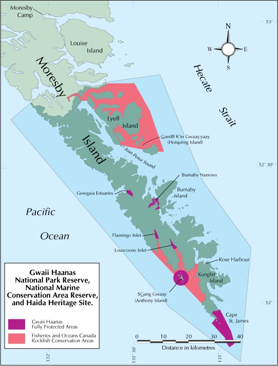
| Shellfish | Gwaii Haanas - Burnaby Narrows | Closed | any gear or method (year round ) |
| Gwaii Haanas - Cape Saint James | Closed | any gear or method (year round ) | |
| Gwaii Haanas - Flamingo Estuary | Closed | any gear or method (year round ) | |
| Gwaii Haanas - Gowgaia Estuary | Closed | any gear or method (year round ) | |
| Gwaii Haanas - Louscoone Estuary | Closed | any gear or method (year round ) | |
| Gwaii Haanas - SGang Gwaay | Closed | any gear or method (year round ) | |
| X̲aana K̲aahlii (Skidegate Inlet) Marine Refuge | Closed | ||
| Bivalve Species | Coastwide | Reminder | When Open, the Possession Limit for bivalve shellfish is twice the Daily Limit. |
| Coastwide | Reminder | Because of the risk of contamination, you are not allowed to harvest bivalve shellfish (for any purpose) within: (1) 300 metres around industrial, municipal and sewage treatment plant outfall discharges (2) 125 metres around a marina, ferry wharf, floating living accommodation, or any finfish net pen (exceptions described as follows) (3) 25 meters around any floating living accommodation facility located within a shellfish aquaculture tenure where a zero-discharge and appropriate waste management plan is a condition of the Aquaculture Licence and is approved by the Regional Interdepartmental Committee (4) 0 meters of any finfish net pen within an aquaculture tenure where an Integrated Multi-Trophic Aquaculture Management Plan approved by the Regional Interdepartmental Committee is in operation. | |
| Coastwide | Reminder | Clams - No person shall retain a Manila Clam or Littleneck Clam smaller than 35 mm, nor a Butter Clam smaller than 55 mm. | |
| Coastwide | Reminder | Only aquaculture operators are allowed to harvest within the boundaries of licenced aquaculture facilities. Please be aware of the location of aquaculture facilities in the areas close to where you are intending to harvest. | |
| Clam - all species combined | Coastwide | Daily Limit Pieces | 60 - When open, all species aggregate daily limit combined Areas 1 to 27 is 60, except Pacific Rim National Park where the all-species aggregate limit is 24. |
| Oyster - all species except Olympia | Skidegate Inlet Oyster Opening | Daily Limit Pieces | 6 |
| Skidegate Inlet Oyster Opening | Possession Limit Pieces | 12 | |
| Coastwide | Reminder | To avoid inadvertently harvesting Olympia oysters while you are harvesting Pacific oysters, do not harvest any oyster less than 5 cm in diameter. |
Last updated: 2026-06-09
Area descriptions
| Closure | Map | Area description |
|---|---|---|
| 2.1 Skidegate Channel | 2.1.png | The waters and intertidal foreshore of Skidegate Inlet lying inside a line drawn from a point on Graham Island located at 53°18.41' north latitude and 131°57.77' west longitude, thence southeasterly to a point in water at 53°17.51' north latitude and 131°56.47' west longitude, thence southerly to a point in water at 53°15.00' north latitude and 131°56.40' west longitude, then southwesterly to a point in water located due south of the Skidegate Landing Public Dock at 53°14.27' north latitude and 132°00.35' west longitude, thence southwesterly to a point on Lina Island at 53°13.58' north latitude and 132°06.06' west longitude, thence northerly and westerly following the shoreline of Lina Island to a point on land at 53°13.99' north latitude and 132°06.80' west longitude, thence northwesterly to a point on Graham Island at 53°15.08' north latitude and 132°07.59' west longitude, thence easterly following the shoreline of Graham Island back to the point of commencement. [NAD83] |
| 2.2 Louscoone Inlet | 2.2.png | The waters and intertidal foreshore of Louscoone Inlet lying within a 200m radius of the large mooring buoy located at 52°10.04' north latitude and 131°12.97' west longitude, between Cadman Point and Etches Point. [NAD83] |
| 2.4 Long Inlet | 2.4.png | The waters and intertidal foreshore of the head of Long Inlet at the west end of Skidegate Inlet, from a point on land at 53°14.10' north latitude and 132°18.86' west longitude, south to a point on land at 53°13.51' north latitude and 132°18.82' west longitude. [NAD83] |
| 2.5 Josette Point | 2.5.png | The waters and intertidal foreshore of the unnamed bay west of Josette Point at the mouth of Long Inlet, lying inside a line drawn from 53°12.12' north latitude and 132°16.26' west longitude, southerly to a point on an unnamed island at 53°12.01' north latitude and 132°16.12' west longitude, thence following the south-westerly shoreline to a point on land at 53°11.99' north latitude and 132°16.02' west longitude, thence north-easterly to a point on land at 53°12.10' north latitude and 132°15.88' W longitude, thence following the shoreline to the point of commencement. [NAD83] |
| 2.6 Unnamed Bay South of Christie Bay | 2.6.png | The waters and intertidal foreshore of the unnamed bay south of Christie Bay at the west end of Skidegate Inlet, lying inside a line drawn from 53°11.99' north latitude and 132°13.07' west longitude, southerly to a point at 53°11.85' north latitude and 132°13.10' west longitude. [NAD83] |
| 2.7 Goski Bay | 2.7.png | The waters and intertidal foreshore of Goski Bay at the north-east end of Gowgaia Bay, lying inside a line drawn from 52°25.72' north latitude and 131°34.29' west longitude, south-easterly to an island at 52°25.22' north latitude and 131°33.53' west longitude, then east to 52°25.33' north latitude and 131°33.13' west longitude. [NAD83] |
| 2.8 A portion of Kagan Bay | 2.8.png | The waters and intertidal foreshore of an unnamed bay in the northeast corner of Kagan Bay, inside a line drawn from a point on land at 53°14.29' north latitude and 132°09.22' west longitude northwesterly to a point on land at 53°14.35' north latitude and 132°09.71' west longitude. [NAD83] |
| 2-12.A | That portion of Subarea 2-12 north of a line from 52°33.121'N and 131°26.656'W to 52°32.462'N and 131°23.569'W. [NAD 83] | |
| 2-12.B | That portion of Subarea 2-12 south of a line from 52°33.121'N and 131°26.656'W to 52°32.462'N and 131°23.569'W. [NAD 83] | |
| 2-31.A | 2-31.A.png | That portion of Subarea 2-31 west of a line running from Cape Fanny (52°07.09' north latitude and 131° 10.70' west longitude) true south to the Subarea boundary. |
| 2-31.B | 2-31.B.png | That portion of Subarea 2-31 east of a line running from Cape Fanny (52 degrees 07.09 minutes north latitude and 131 degrees 10.70 minutes west longitude) true south to the Subarea boundary. |
| 2-7.A | That portion of Subarea 2-7 north of a line from 52°55.400'N and 131°37.140'W to 52°55.400'N and 131°31.230'W. [NAD 83] | |
| 2-7.B | That portion of Subarea 2-7 south of a line from 52°55.400'N and 131°37.140'W to 52°55.400'N and 131°31.230'W. [NAD 83] |
Last updated: 2026-06-09
| Area | Map | Area description |
|---|---|---|
| Coastwide | ||
| Gwaii Haanas - Burnaby Narrows | Gwaii Haanas - Burnaby Narrows | Those waters of Subareas 2-13 and 2-16 inside a line commencing at 52º23.049' N 131º23.438' W. Easterly to a point 52º23.077' N 131º22.908' W then following the southern shoreline of Kat Island easterly to a point 52º23.107' N 131º22.274' W then east to a point 52º23.295' N 131º21.34' W then following the western shoreline of Burnaby Island southerly to a point 52º20.951' N 131º20.509'W then west to a point 52º20.733' N 131º21.072' W then northerly following the eastern shoreline of Moresby Island back to the point of commencement. |
| Gwaii Haanas - Cape Saint James | Gwaii Haanas - Cape Saint James | Those waters of Subareas 2-19, 102-3, 130-3 and 142-1 inside a line commencing at 51º56.523' N 131º01.522' W. Southwesterly to a point 51º55.627' N 131º02.574' W then southeasterly to a point 51º52.500' N 130º57.919' W then southerly to a point 51º51.676' N 130º57.805' W then southeasterly to a point 51º50.349' N 130º56.442' W then northeasterly to a point 51º51.062' N 130º54.717' W then northerly to a point 51º53.888' N 130º55.608' W then northwesterly to a point 51º58.671' N 130º59.464' W then westerly to a point 51º58.743' N 131º00.606' W then westerly following the southern shoreline of Kungit Island back to the point of commencement. |
| Gwaii Haanas - Flamingo Estuary | Gwaii Haanas - Flamingo Estuary | Those waters of Subarea 2-37 north of a line drawn from 52º14.456' north latitude and 131º22.234' west longitude southeasterly to 52º14.246' north latitude and 131º21.489' west longitude. |
| Gwaii Haanas - Gowgaia Estuary | Gwaii Haanas - Gowgaia Estuary | Those waters of Subarea 2-41 east of a line drawn from 52º24.944' north latitude and 131º32.138' west longitude southeasterly to 52º24.238' north latitude and 131º32.024' west longitude. |
| Gwaii Haanas - Louscoone Estuary | Gwaii Haanas - Louscoone Estuary | Those waters of Subareas 2-33 and 2-34 north of a line drawn from 52º11.836' north latitude and 131º15.658' west longitude easterly to 52º12.271' north latitude and 131º14.594' west longitude. |
| Gwaii Haanas - SGang Gwaay | Gwaii Haanas - SGang Gwaay | Those waters of Subareas 2-31 and 142-1 inside a 3km radius from the centre point on Anthony Island located at 52º05.655' north latitude and 131º13.178' west longitude. |
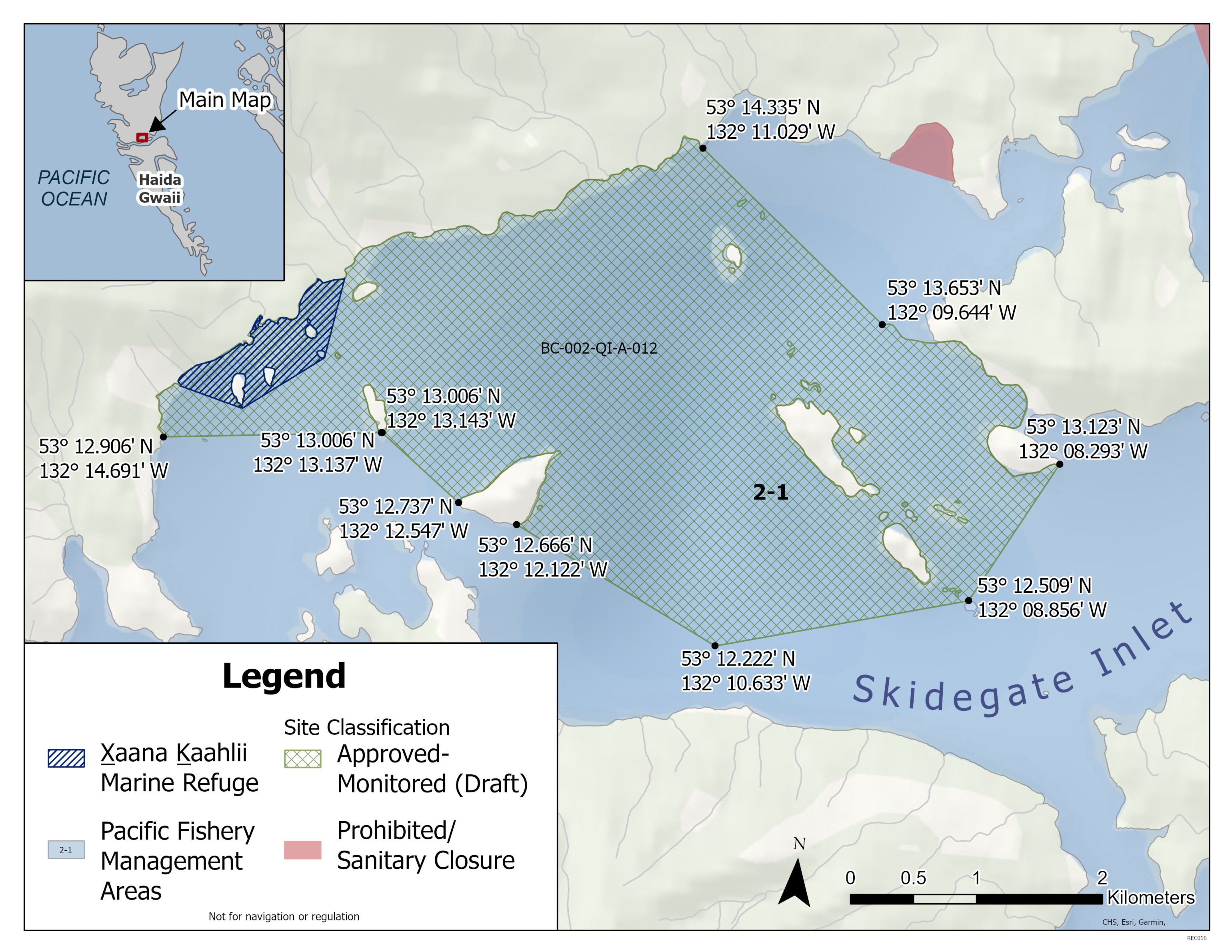
| Skidegate Inlet Oyster Opening | Skidegate Inlet Oyster Opening | The waters and intertidal foreshore of that portion of Subarea 2-1 inside a line that commences at 53°14.335'N, 132°11.029'W [Kagan Bay, Graham Island], then in a straight line to 53°13.660'N, 132°09.661'W [Lina Island] then following the shoreline to 53°13.123'N, 132°08.293'W then in a straight line to 53°12.509'N, 132°08.856'W [Angle Island], then in a straight line to 53°12.223'N, 132°10.634'W [in water], then in a straight line to 53°12.666'N, 132°12.122'W [Legace Island], then following the east shoreline to 53°12.737'N, 132°12.547'W, then in a straight line to 53°13.006'N, 132°13.137'W [Treble Island] then in a straight line to 53°12.906'N, 132°14.691'W [Graham Island.] then following the shoreline to the point of commencement. [NAD83] EXCEPT That portion of subarea 2-1 that lies inside a line commencing at 53°13.649'N, 132°13.500'W, then southerly to a point on land at 53°13.303'N, 132°13.595'W, then southerly to a point on land 53°13.056'N, 132°14.151'W, then easterly to a point on land at 53°13.129'N, 132°14.603'W, then northerly to the beginning point. |
| X̲aana K̲aahlii (Skidegate Inlet) Marine Refuge | X̲aana K̲aahlii (Skidegate Inlet) Marine Refuge | Tllgaduu G̲andlaay Sɢ̲aagiidaay (Slatechuk Creek): That portion of subarea 2-1 that lies inside a line commencing at 53° 13.649' N, 132° 13.500' W then southerly to a point on land at 53° 13.303' N, 132° 13.595' W then southerly to a point on land 53° 13.056' N, 132° 14.151' W then easterly to a point on land at 53° 13.129' N, 132° 14.603' W then northerly to the beginning point. Diina (Deena Creek): That portion of subarea 2-1 that lies inside a line commencing at 53° 09.415' N, 132° 06.870' W then south easterly to a point on land at 53° 09.105' N, 132° 05.650' W then westerly following the shoreline to 53° 09.246' N, 132° 07.064' W then northerly to a point in water at 53° 09.306' N, 132° 07.036' W then northerly to a point in water at 53° 09.381' N, 132° 06.947' W then northerly to the beginning point. Hlɢ̲aagilda Llnagaay Sɢ̲aagiidaay (Skidegate): That portion of subarea 2-1 that lies inside a line commencing at 53° 17.933' N, 131° 57.984' W then easterly to a point in water at 53° 17.887' N, 131° 57.517' W then southerly to a point in water at 53° 15.335' N, 131° 58.180' W then southerly to a point in water at 53° 14.616' N, 131° 58.830' W then north westerly to a point on land at 53° 14.856' N, 131° 59.749' W then northerly to the beginning point. |
Last updated: 2026-06-09
Crab
Crab
- It is illegal to possess female Dungeness, King, Puget Sound King, Brown Box and Red Rock crabs. Female crabs must be released immediately. New
- Invasive European green crab
- Learn more about fishing for crab
Species regulations
Always check for restrictions.
| Species | Areas | Min size | Gear | Daily Limits | Status |
|---|---|---|---|---|---|
| Crab - Box | 2,102,130,142 | dip net, hand picking, hand picking while diving, ring net, trap | 1 | Open | |
| Crab - Dungeness | 2,102,130,142 | 165mm | dip net, hand picking, hand picking while diving, ring net, trap | 6 | Open |
| Crab - Dungeness, Red Rock and King combined | 2,102,130,142 | dip net, hand picking, hand picking while diving, ring net, trap | 6 | Open | |
| Crab - King | 2,102,130,142 | dip net, diving, ring net, trap | 2 | Open | |
| Crab - Puget Sound King | 2,102,130,142 | dip net, hand picking, hand picking while diving, ring net, trap | 1 | Open | |
| Crab - Red Rock | 2,102,130,142 | 115mm | dip net, hand picking, hand picking while diving, ring net, trap | 6 | Open |
| Crab - Shore | 2,102,130,142 | hand picking | 25 | Open | |
| Crab - other | 2,102,130,142 | dip net, hand picking, hand picking while diving, ring net, trap | 4 | Open |
Last updated: 2026-06-09
Restrictions
Always check for protected areas.
| Species | Areas | Restriction type | Restriction details |
|---|---|---|---|
| Shellfish | Gwaii Haanas - Burnaby Narrows | Closed | any gear or method (year round ) |
| Gwaii Haanas - Cape Saint James | Closed | any gear or method (year round ) | |
| Gwaii Haanas - Flamingo Estuary | Closed | any gear or method (year round ) | |
| Gwaii Haanas - Gowgaia Estuary | Closed | any gear or method (year round ) | |
| Gwaii Haanas - Louscoone Estuary | Closed | any gear or method (year round ) | |
| Gwaii Haanas - SGang Gwaay | Closed | any gear or method (year round ) | |
| X̲aana K̲aahlii (Skidegate Inlet) Marine Refuge | Closed | ||
| Crab | Coastwide | Reminder | Keep navigation channels clear of buoys and lines. Any fishing gear that interferes with safe navigation can be removed under the Navigation Protection Act. |
| Coastwide | Reminder | As per the British Columbia Sport Fishing Regulations, 1996 - Maximum of 2 ring nets, dip nets or traps or combination of these per fisher. Ensure gear is properly marked. Hand picking is permitted including by diving. No sharp-pointed instruments are permitted for harvesting crab. It is illegal to use snares in catching or attempting to catch crabs. | |
| Coastwide | Reminder | Rot Cord - As per the British Columbia Sport Fishing Regulations, 1996, all crab traps must have a section in the top or sidewall that has been secured by a single length of untreated cotton twine no greater than No. 120 (approximately 5 mm or 3/16 inch diameter). This twine is often referred to as rot cord. On deterioration this must produce a rectangular opening with a minimum size of 7 cm x 20 cm, or a square opening with a minimum size of 11 cm x 11 cm. This regulation is intended to ensure that if the trap is lost, the section secured by the cord will rot, allowing captive crabs to escape, and preventing the trap from continuing to fish. On traps with a rigid frame and a freely opening hinged lid, the trap lid must be secured by a single length of untreated cotton twine no greater than No. 120 so that the trap lid will open freely when the rot cord is broken. No other fastenings may impede the hinged lid of the trap from opening. | |
| Coastwide | Reminder | Crab, prawn and shrimp floats - As a Condition of Licence, the primary float attached to crab traps must be cylindrical in shape (includes bullet shaped) and a minimum of 27 cm in length and 12 cm in diameter; an optional secondary float may be used of any shape or size other than spherical. The primary float attached to prawn and shrimp traps must be spherical in shape and a minimum of 27 cm in diameter; an optional secondary float may be used of any shape or size other than cylindrical. | |
| Coastwide | Reminder | Floats must be made of a durable material and suitable for operation in marine waters. Floats/materials not suitable for use in marine waters are prohibited. | |
| Coastwide | Reminder | As per the British Columbia Sport Fishing Regulations, 1996 - Traps must be marked with a tag, float or buoy that has your name and telephone number on it. This includes traps tied to a boat or dock or fished from shore. If two traps are attached to one ground-line, it is sufficient to attach a tag, float or buoy that bears the operator's name and telephone number to one end of the ground-line. | |
| Coastwide | Reminder | As per the British Columbia Sport Fishing Regulations, 1996 - A line or rope attached to a trap must be submerged in such a manner that the line or rope does not come into contact with a person or a boat. | |
| Coastwide | Reminder | As a Condition of Licence, crab traps are required to have two unobstructed circular escape holes or rings, measuring a minimum of 105 mm in diameter. | |
| Coastwide | Reminder | When Open, the Possession Limit for crab is twice the Daily Limit. | |
| Crab - Dungeness | Coastwide | Packaging and Transporting | In order to be accurately measured, the carapace of Dungeness crab that you catch must remain attached until the crab arrives at your residence or it is consumed. |
| Coastwide | Sex Restriction | It is prohibited to possess female Dungeness crab. | |
| Crab - Red Rock | Coastwide | Packaging and Transporting | In order to be accurately measured, the carapace of Red Rock crab that you catch must remain attached until the crab arrives at your residence or it is consumed. |
| Coastwide | Sex Restriction | It is prohibited to possess female Red Rock crab. | |
| Crab - King | Coastwide | Packaging and Transporting | In order to be accurately measured, the carapace of King crab that you catch must remain attached until the crab arrives at your residence or it is consumed. |
| Coastwide | Sex Restriction | It is prohibited to possess female King crab. | |
| Crab - Puget Sound King | Coastwide | Sex Restriction | As a Condition of Licence, it is prohibited to possess female Puget Sound King Crab. |
| Crab - Brown Box | Coastwide | Sex Restriction | As a Condition of Licence, it is prohibited to possess female Brown Box Crab. |
Last updated: 2026-06-09
Area descriptions
| Area | Map | Area description |
|---|---|---|
| Coastwide | ||
| Gwaii Haanas - Burnaby Narrows | Gwaii Haanas - Burnaby Narrows | Those waters of Subareas 2-13 and 2-16 inside a line commencing at 52º23.049' N 131º23.438' W. Easterly to a point 52º23.077' N 131º22.908' W then following the southern shoreline of Kat Island easterly to a point 52º23.107' N 131º22.274' W then east to a point 52º23.295' N 131º21.34' W then following the western shoreline of Burnaby Island southerly to a point 52º20.951' N 131º20.509'W then west to a point 52º20.733' N 131º21.072' W then northerly following the eastern shoreline of Moresby Island back to the point of commencement. |
| Gwaii Haanas - Cape Saint James | Gwaii Haanas - Cape Saint James | Those waters of Subareas 2-19, 102-3, 130-3 and 142-1 inside a line commencing at 51º56.523' N 131º01.522' W. Southwesterly to a point 51º55.627' N 131º02.574' W then southeasterly to a point 51º52.500' N 130º57.919' W then southerly to a point 51º51.676' N 130º57.805' W then southeasterly to a point 51º50.349' N 130º56.442' W then northeasterly to a point 51º51.062' N 130º54.717' W then northerly to a point 51º53.888' N 130º55.608' W then northwesterly to a point 51º58.671' N 130º59.464' W then westerly to a point 51º58.743' N 131º00.606' W then westerly following the southern shoreline of Kungit Island back to the point of commencement. |
| Gwaii Haanas - Flamingo Estuary | Gwaii Haanas - Flamingo Estuary | Those waters of Subarea 2-37 north of a line drawn from 52º14.456' north latitude and 131º22.234' west longitude southeasterly to 52º14.246' north latitude and 131º21.489' west longitude. |
| Gwaii Haanas - Gowgaia Estuary | Gwaii Haanas - Gowgaia Estuary | Those waters of Subarea 2-41 east of a line drawn from 52º24.944' north latitude and 131º32.138' west longitude southeasterly to 52º24.238' north latitude and 131º32.024' west longitude. |
| Gwaii Haanas - Louscoone Estuary | Gwaii Haanas - Louscoone Estuary | Those waters of Subareas 2-33 and 2-34 north of a line drawn from 52º11.836' north latitude and 131º15.658' west longitude easterly to 52º12.271' north latitude and 131º14.594' west longitude. |
| Gwaii Haanas - SGang Gwaay | Gwaii Haanas - SGang Gwaay | Those waters of Subareas 2-31 and 142-1 inside a 3km radius from the centre point on Anthony Island located at 52º05.655' north latitude and 131º13.178' west longitude. |
| X̲aana K̲aahlii (Skidegate Inlet) Marine Refuge | X̲aana K̲aahlii (Skidegate Inlet) Marine Refuge | Tllgaduu G̲andlaay Sɢ̲aagiidaay (Slatechuk Creek): That portion of subarea 2-1 that lies inside a line commencing at 53° 13.649' N, 132° 13.500' W then southerly to a point on land at 53° 13.303' N, 132° 13.595' W then southerly to a point on land 53° 13.056' N, 132° 14.151' W then easterly to a point on land at 53° 13.129' N, 132° 14.603' W then northerly to the beginning point. Diina (Deena Creek): That portion of subarea 2-1 that lies inside a line commencing at 53° 09.415' N, 132° 06.870' W then south easterly to a point on land at 53° 09.105' N, 132° 05.650' W then westerly following the shoreline to 53° 09.246' N, 132° 07.064' W then northerly to a point in water at 53° 09.306' N, 132° 07.036' W then northerly to a point in water at 53° 09.381' N, 132° 06.947' W then northerly to the beginning point. Hlɢ̲aagilda Llnagaay Sɢ̲aagiidaay (Skidegate): That portion of subarea 2-1 that lies inside a line commencing at 53° 17.933' N, 131° 57.984' W then easterly to a point in water at 53° 17.887' N, 131° 57.517' W then southerly to a point in water at 53° 15.335' N, 131° 58.180' W then southerly to a point in water at 53° 14.616' N, 131° 58.830' W then north westerly to a point on land at 53° 14.856' N, 131° 59.749' W then northerly to the beginning point. |
Last updated: 2026-06-09
Other invertebrates
Other invertebrates
- Basic information about shellfish harvesting
- Seasonal recreational harvesting closures for prawn and shrimp
Species regulations
Always check for restrictions.
| Species | Areas | Gear | Daily Limits | Status |
|---|---|---|---|---|
| Abalone | 2,102,130,142 | 0 | Closed | |
| Barnacles - Giant | 2,102,130,142 | diving | 6 | Open |
| Barnacles - Goose | 2,102,130,142 | hand picking | 2kg | Open |
| Invertebrates - all other species | 2,102,130,142 | angling, dip net, hand digging, hand picking, hand picking while diving, hand picking while snorkeling, hand pump, ring net, spear fishing while diving, trap | 20 | Open |
| Limpet | 2,102,130,142 | hand picking | 75 | Open |
| Octopus | 2,102,130,142 | angling, hand picking, hand picking while diving, trap | 1 | Open |
| Sand Dollar | 2,102,130,142 | hand picking | 6 | Open |
| Sea Cucumber | 2,102,130,142 | hand picking, hand picking while diving | 12 | Open |
| Sea Star or Starfish | 2,102,130,142 | diving, hand picking | 6 | Open |
| Sea Urchin | 2,102,130,142 | hand picking, hand picking while diving | 12 | Open |
| Shellfish - all other species | 2,102,130,142 | angling, dip net, hand digging, hand picking, hand picking while diving, hand pump, ring net, spear fishing while diving, trap | 20 | Open |
| Shrimp - Ghost | 2,102,130,142 | hand digging, hand pump | 50 | Open |
| Shrimp including prawn | 2,102,130,142 | ring net, spear fishing while diving, trap | 125 | Open |
| Squid - Opal | 2,102,130,142 | cast net, jigging | 200 | Open |
| Squid - all other species | 2,102,130,142 | cast net, jigging | 20 | Open |
Last updated: 2026-06-09
Restrictions
Always check for protected areas.
| Species | Areas | Restriction type | Restriction details |
|---|---|---|---|
| Shellfish | Gwaii Haanas - Burnaby Narrows | Closed | any gear or method (year round ) |
| Gwaii Haanas - Cape Saint James | Closed | any gear or method (year round ) | |
| Gwaii Haanas - Flamingo Estuary | Closed | any gear or method (year round ) | |
| Gwaii Haanas - Gowgaia Estuary | Closed | any gear or method (year round ) | |
| Gwaii Haanas - Louscoone Estuary | Closed | any gear or method (year round ) | |
| Gwaii Haanas - SGang Gwaay | Closed | any gear or method (year round ) | |
| X̲aana K̲aahlii (Skidegate Inlet) Marine Refuge | Closed | ||
| Other Invertebrates | Coastwide | Reminder | When Open, the Possession Limit for other invertebrates is twice the Daily Limit. |
| Coastwide | Reminder | Rot Cord - As per the British Columbia Sport Fishing Regulations, 1996, all open mesh octopus traps and shrimp/prawn traps must have a section in the top or sidewall that has been secured by a single length of untreated cotton twine no greater than No. 120 (approximately 5 mm or 3/16 inch diameter). This twine is often referred to as rot cord. On deterioration this must produce a rectangular opening with a minimum size of 7 cm x 20 cm, or a square opening with a minimum size of 11 cm x 11 cm. This regulation is intended to ensure that if the trap is lost, the section secured by the cord will rot, allowing captive crabs to escape, and preventing the trap from continuing to fish. On traps with a rigid frame and a freely opening hinged lid the trap lid must be secured by a single length of untreated cotton twine no greater than No. 120 so that the trap lid will open freely when the rot cord is broken. No other fastenings may impede the hinged lid of the trap from opening. | |
| Coastwide | Reminder | As per the British Columbia Sport Fishing Regulations, 1996 - Traps must be marked with a tag, float or buoy that has your name and telephone number on it. This includes traps tied to a boat or dock or fished from shore. If two traps are attached to one ground-line, it is sufficient to attach a tag, float or buoy that bears the operator's name and telephone number to one end of the ground-line. | |
| Coastwide | Reminder | As per the British Columbia Sport Fishing Regulations, 1996 - A line or rope attached to a trap must be submerged in such a manner that the line or rope does not come into contact with a person or a boat. | |
| Coastwide | Reminder | Floats must be made of a durable material and suitable for operation in marine waters. Floats/materials not suitable for use in marine waters are prohibited. | |
| Octopus | Coastwide | Reminder | The use of sharp pointed instruments or chemicals is prohibited. |
| Shrimp including prawn | Coastwide | Reminder | Spot Prawns (Pandalus platyceros) with eggs - No person shall retain prawns carrying eggs, or remove eggs from the underside of prawns carrying eggs. All prawns carrying eggs externally on the underside of the tail shall be returned to the water immediately and in the manner that causes the least harm. |
| Coastwide | Reminder | As per the British Columbia Sport Fishing Regulations, 1996 - Maximum 4 traps or ring nets or combination of these per fisher. | |
| Coastwide | Reminder | Crab, prawn and shrimp floats - As a Condition of Licence, the primary float attached to crab traps must be cylindrical in shape (includes bullet shaped) and a minimum of 27 cm in length and 12 cm in diameter; an optional secondary float may be used of any shape or size other than spherical. The primary float attached to prawn and shrimp traps must be spherical in shape and a minimum of 27 cm in diameter; an optional secondary float may be used of any shape or size other than cylindrical. |
Last updated: 2026-06-09
Area descriptions
| Area | Map | Area description |
|---|---|---|
| Coastwide | ||
| Gwaii Haanas - Burnaby Narrows | Gwaii Haanas - Burnaby Narrows | Those waters of Subareas 2-13 and 2-16 inside a line commencing at 52º23.049' N 131º23.438' W. Easterly to a point 52º23.077' N 131º22.908' W then following the southern shoreline of Kat Island easterly to a point 52º23.107' N 131º22.274' W then east to a point 52º23.295' N 131º21.34' W then following the western shoreline of Burnaby Island southerly to a point 52º20.951' N 131º20.509'W then west to a point 52º20.733' N 131º21.072' W then northerly following the eastern shoreline of Moresby Island back to the point of commencement. |
| Gwaii Haanas - Cape Saint James | Gwaii Haanas - Cape Saint James | Those waters of Subareas 2-19, 102-3, 130-3 and 142-1 inside a line commencing at 51º56.523' N 131º01.522' W. Southwesterly to a point 51º55.627' N 131º02.574' W then southeasterly to a point 51º52.500' N 130º57.919' W then southerly to a point 51º51.676' N 130º57.805' W then southeasterly to a point 51º50.349' N 130º56.442' W then northeasterly to a point 51º51.062' N 130º54.717' W then northerly to a point 51º53.888' N 130º55.608' W then northwesterly to a point 51º58.671' N 130º59.464' W then westerly to a point 51º58.743' N 131º00.606' W then westerly following the southern shoreline of Kungit Island back to the point of commencement. |
| Gwaii Haanas - Flamingo Estuary | Gwaii Haanas - Flamingo Estuary | Those waters of Subarea 2-37 north of a line drawn from 52º14.456' north latitude and 131º22.234' west longitude southeasterly to 52º14.246' north latitude and 131º21.489' west longitude. |
| Gwaii Haanas - Gowgaia Estuary | Gwaii Haanas - Gowgaia Estuary | Those waters of Subarea 2-41 east of a line drawn from 52º24.944' north latitude and 131º32.138' west longitude southeasterly to 52º24.238' north latitude and 131º32.024' west longitude. |
| Gwaii Haanas - Louscoone Estuary | Gwaii Haanas - Louscoone Estuary | Those waters of Subareas 2-33 and 2-34 north of a line drawn from 52º11.836' north latitude and 131º15.658' west longitude easterly to 52º12.271' north latitude and 131º14.594' west longitude. |
| Gwaii Haanas - SGang Gwaay | Gwaii Haanas - SGang Gwaay | Those waters of Subareas 2-31 and 142-1 inside a 3km radius from the centre point on Anthony Island located at 52º05.655' north latitude and 131º13.178' west longitude. |
| X̲aana K̲aahlii (Skidegate Inlet) Marine Refuge | X̲aana K̲aahlii (Skidegate Inlet) Marine Refuge | Tllgaduu G̲andlaay Sɢ̲aagiidaay (Slatechuk Creek): That portion of subarea 2-1 that lies inside a line commencing at 53° 13.649' N, 132° 13.500' W then southerly to a point on land at 53° 13.303' N, 132° 13.595' W then southerly to a point on land 53° 13.056' N, 132° 14.151' W then easterly to a point on land at 53° 13.129' N, 132° 14.603' W then northerly to the beginning point. Diina (Deena Creek): That portion of subarea 2-1 that lies inside a line commencing at 53° 09.415' N, 132° 06.870' W then south easterly to a point on land at 53° 09.105' N, 132° 05.650' W then westerly following the shoreline to 53° 09.246' N, 132° 07.064' W then northerly to a point in water at 53° 09.306' N, 132° 07.036' W then northerly to a point in water at 53° 09.381' N, 132° 06.947' W then northerly to the beginning point. Hlɢ̲aagilda Llnagaay Sɢ̲aagiidaay (Skidegate): That portion of subarea 2-1 that lies inside a line commencing at 53° 17.933' N, 131° 57.984' W then easterly to a point in water at 53° 17.887' N, 131° 57.517' W then southerly to a point in water at 53° 15.335' N, 131° 58.180' W then southerly to a point in water at 53° 14.616' N, 131° 58.830' W then north westerly to a point on land at 53° 14.856' N, 131° 59.749' W then northerly to the beginning point. |
Last updated: 2026-06-09
Protected areas
Protected areas
Learn about permanent restrictions that are in effect:
Find detailed maps and coordinates for protected areas in the Canadian Pacific
Learn about rules you need to follow to protect Southern Resident killer whales
| Area | Type | Closure name |
|---|---|---|
| 2-1 | Marine Refuge | X̲aana K̲aahlii (Skidegate Inlet) Marine Refuge |
| 2-7 | National Marine Conservation Area Reserve | T`aanuu K`aadxwah Xyangs sda Gwaay Xaa`ans |
| 2-8 | National Marine Conservation Area Reserve | T`aanuu K`aadxwah Xyangs sda Gwaay Xaa`ans |
| 2-10 | National Marine Conservation Area Reserve | Didxwahxyangs (Darwin Sound) |
| 2-11 | National Marine Conservation Area Reserve | Gandaawuu.ngaay Xyangs sda Tllga Kun Gwaay.yaay |
| 2-12 | National Marine Conservation Area Reserve | Kuuniisii Xaw GawGa sda Gaaduu Gwaay |
| 2-13 | National Marine Conservation Area Reserve | Kuuniisii Xaw GawGa sda Gaaduu Gwaay |
| Suu Kaahlii sda SGwaay Kun Gwaay.yaay | ||
| 2-14 | National Marine Conservation Area Reserve | Gid Gwaa GyaaGa GawGa (Poole Inlet) |
| Suu Kaahlii sda SGwaay Kun Gwaay.yaay | ||
| 2-15 | National Marine Conservation Area Reserve | GawGan (Huston Inlet) |
| Suu Kaahlii sda SGwaay Kun Gwaay.yaay | ||
| 2-16 | National Marine Conservation Area Reserve | Suu Kaahlii sda SGwaay Kun Gwaay.yaay |
| 2-17 | National Marine Conservation Area Reserve | Kayjuu Kun (Benjamin Point) |
| 2-18 | National Marine Conservation Area Reserve | K`insiGid (Rose Inlet) |
| Kayjuu Kun (Benjamin Point) | ||
| 2-19 | National Marine Conservation Area Reserve | GangXid Tllgaay (South Kunghit Island) |
| 2-31 | National Marine Conservation Area Reserve | SGang Gwaay (Wailing Island) |
| 2-34 | National Marine Conservation Area Reserve | GawGajaang (Louscoone Inlet) |
| 2-37 | National Marine Conservation Area Reserve | St`aa K`ii GawGa (Flamingo Inlet) |
| 2-38 | National Marine Conservation Area Reserve | Kun Skuujii sda GawGaay.ya |
| 2-39 | National Marine Conservation Area Reserve | Kun Skuujii sda GawGaay.ya |
| 2-40 | National Marine Conservation Area Reserve | Kun Skuujii sda GawGaay.ya |
| 2-41 | National Marine Conservation Area Reserve | Kun Skuujii sda GawGaay.ya |
| 102-2 | National Marine Conservation Area Reserve | Gandaawuu.ngaay Xyangs sda Tllga Kun Gwaay.yaay |
| GangXid Xyuu Kun sda Kan `Láas Kun | ||
| Kayjuu Kun (Benjamin Point) | ||
| Suu Kaahlii sda SGwaay Kun Gwaay.yaay | ||
| 102-3 | National Marine Conservation Area Reserve | GangXid Tllgaay (South Kunghit Island) |
| GangXid Xyuu Kun sda Kan `Láas Kun | ||
| 130-1 | Marine Protected Area | The Tang.ɢ̱wan - ḥačxwiqak - Tsig̱is (TḥT) |
| 130-3 | National Marine Conservation Area Reserve | GangXid Tllgaay (South Kunghit Island) |
| 142 | Marine Protected Area | Bowie Seamount Marine Protected Area |
| 142-1 | National Marine Conservation Area Reserve | GangXid Tllgaay (South Kunghit Island) |
| Kun Skuujii sda GawGaay.ya | ||
| SGang Gwaay (Wailing Island) | ||
| 142-2 | Rockfish Conservation Area | Frederick Island |
Last updated: 2026-06-09
Area descriptions
| Area | Map | Area description |
|---|---|---|
| Bowie Seamount Marine Protected Area | Bowie Seamount Marine Protected Area | Those waters of Subareas 101-1 and 142-2 inside a line commencing at 53º03'07.6' N 135º50'25.9' W to a point 53º16'20.9' N 134º59'55.4' W then to a point 53º39'49.2' N 135º17'04.9' W then to a point 53º39'18.0' N 135º53'46.5' W then to a point 53º52'16.7' N 136º30'23.1' W EEZ Boundary then following the EEZ Boundary to 53º49'19.6' N 136º47'33.1? W EEZ Boundary then to a point 53º40'02.5' N 136º57'03.5' W then to a point 53º13'59.2' N 136º10'00.0' W then back to the point of commencement. [Bowie Seamount Marine Protected Area] |
| Didxwahxyangs (Darwin Sound) | Didxwahxyangs (Darwin Sound) | Those waters of Subarea 2-10 inside a line commencing at a point on land on Shuttle Island at 52°40.053`N and 131°42.328`W northeasterly to a point on the western shoreline of Tllga Kun Gwaay.yaay (Lyell Island) at 52°40.466`N and 131°41.105`W, thence southerly following the western shoreline of Tllga Kun Gwaay.yaay (Lyell Island) to 52°37.301`N and 131°38.800`W, thence northwesterly to a point on land of Gwaay DaaGaaw (Shuttle Island) at 52°38.522`N and 131°41.409`W, and thence following the eastern shoreline of Shuttle Island to the beginning point. |
| Frederick Island | Frederick Island | Those waters of Subareas 1-1, 101-1 and 142-2 that lie inside a line that: begins at 53°56.246'N 133°17.500'W in water then to 53°56.246'N 133°11.862'W Hope Point then to 53°56.737'N 133°08.036'W Morgan Point then southerly following the shoreline of Graham Island to the intersection with the parallel passing through 53°47.000' north latitude, then to 53°47.000'N 133°10.000'W in water then to the beginning point. |
| Gandaawuu.ngaay Xyangs sda Tllga Kun Gwaay.yaay | Gandaawuu.ngaay Xyangs sda Tllga Kun Gwaay.yaay | Gandaawuu.ngaay Xyangs sda Tllga Kun Gwaay.yaay also known as Juan Perez Sound to Lyell Island. Those waters of Subareas 2-11 and 102-2 inside a line commencing on the eastern shoreline of Tllga Kun Gwaay.yaay (Lyell Island) at 52°42.074`N and 131°26.535`W southeasterly to a point in water at 52°41.073`N and 131°14.523`W, thence southeasterly to a point in water at 52°38.666`N and 131°12.987`W, thence southwesterly to 52°35.106`N and 131°22.254`W, thence following the northern shoreline of Xiina Gwaay.yaay (Ramsay Island) to 52°34.964`N and 131°22.963`W, thence southwesterly across to 52°34.116`N and 131°25.603`W, thence southwesterly across to 52°33.844`N and 131°26.324`W, thence southwesterly to a point on Gandaawuu.ngaay Gwaay.yaay (Marco Island) at 52°31.498`N and 131°30.354`W, thence northwesterly to a point on Gandaawuu.ngaay Gwaayts`idaay (Hoskins Islets) at 52°32.405`N and 131°32.946`W, thence following the northern shoreline of Gandaawuu.ngaay Gwaayts`idaay (Hoskins Islets) to 52°32.435`N and 131°33.055`W, thence southwesterly to a point on the eastern shoreline of T`aaxwii XaaydaGa Gwaay.yaay iinaGwaay (Moresby Island) at 52°32.211`N and 131°34.475`W, thence westerly following the eastern shoreline to 52°32.956`N and 131°37.729`W, thence northeasterly to a point on the shoreline of Kingts`ii Gwaay.yaay (Bischof Islands) at 52°34.143`N and 131°33.379`W, thence easterly following the southeastern shoreline of Kingts`ii Gwaay.yaay (Bischof Islands) to 52°34.340`N and 131°33.098`W, thence northeasterly following the southeastern shoreline to a point on an islet at 52°34.530`N and 131°32.890`W, thence northeasterly to a point on the southern shoreline of Tllga Kun Gwaay.yaay (Lyell Island) at 52°35.767`N and 131°32.891`W, and thence easterly and northerly following the shoreline of Tllga Kun Gwaay.yaay (Lyell Island) to the beginning point. |
| GangXid Tllgaay (South Kunghit Island) | GangXid Tllgaay (South Kunghit Island) | Those waters of Subareas 2-19, 102-3, 130-3 and 142-1 inside a line commencing at a point on the western shoreline of GangXid Tllgaay (South Kunghit Island) at 51°57.689`N and 131°03.375`W easterly following the southern shoreline of GangXid Tllgaay (South Kunghit Island) to 52°00.343`N and 130°59.788`W, thence southeasterly to a point in water at 51°50.159`N and 130°53.207`W, thence southwesterly to a point in water at 51°47.954`N and 130°53.613`W, thence northwesterly to a point in water at 51°54.927`N and 131°07.801`W, and thence northeasterly to the beginning point. |
| GangXid Xyuu Kun sda Kan `Láas Kun | GangXid Xyuu Kun sda Kan `Láas Kun | GangXid Xyuu Kun sda Kan `Láas Kun also known as Lyman Point to Receiver Point. Those waters of Subareas 102-2 and 102-3 inside a line commencing at a point on land of Kildaga T`awts`iiGaay (islet) at 52°04.541`N and 130°56.293`W following the shoreline of the islet to 52°04.598`N and 130°56.368`W, thence northwesterly to the eastern shoreline of GangXid Gwaay.yaay (Kunghit Island) at 52°04.652`N and 130°56.414`W, thence northerly following the eastern shoreline of GangXid Gwaay.yaay (Kunghit Island) to 52°05.734`N and 130°56.365`W, thence northeasterly to a point in water at 52°10.225`N and 130°49.512`W, thence southwesterly to a point in water at 52°02.632`N and 130°50.910`W, thence northwesterly back to the beginning point. |
| GawGajaang (Louscoone Inlet) | GawGajaang (Louscoone Inlet) | Those waters of Subarea 2-34 north of a line drawn from a point on land on T`aaxwii XaaydaGa Gwaay.yaay iinaGwaay (Moresby Island) at 52°11.841`N and 131°15.670`W northeasterly across the inlet to a point on the opposite shoreline of GawGajaang (Louscoone Inlet) at 52°12.245`N and 131°14.568`W. |
| GawGan (Huston Inlet) | GawGan (Huston Inlet) | Those waters of Subarea 2-15 south of a line drawn from a point on the western shoreline of GawGan (Huston Inlet) at 52°15.732`N and 131°15.643`W northeasterly across the inlet to a point on the opposite shore at 52°16.111`N and 131°14.231`W. |
| Gid Gwaa GyaaGa GawGa (Poole Inlet) | Gid Gwaa GyaaGa GawGa (Poole Inlet) | Those waters of Subarea 2-14 south of a line drawn from a point on the shoreline of SGwaay Kun Gwaay.yaay (Burnaby Island) in Gid Gwaa GyaaGa GawGa (Poole Inlet) at 52°22.764`N and 131°18.249`W southeasterly across the inlet to a point on the opposite shore at 52°22.505`N and 131°17.665`W. |
| K`insiGid (Rose Inlet) | K`insiGid (Rose Inlet) | Those waters of Subarea 2-18 north of a line drawn from the western shoreline of K`insiGid (Rose Inlet) on T`aaxwii XaaydaGa Gwaay.yaay iinaGwaay (Moresby Island) at 52°11.327`N and 131°08.370`W easterly across the inlet to a point on the opposite shore at 52°11.328`N and 131°07.115`W. |
| Kayjuu Kun (Benjamin Point) | Kayjuu Kun (Benjamin Point) | Those waters of Subareas 2-17, 2-18 and 102-2 inside a line commencing at a point on the eastern shoreline of T`aaxwii XaaydaGa Gwaay.yaay iinaGwaay (Moresby Island) at 52°10.262`N and 131°01.993`W northerly following the eastern shoreline to 52°13.232`N and 131°00.777`W, thence northeasterly to a point in water at 52°17.724`N and 130°55.078`W, thence southeasterly to a point in water at 52°12.476`N and 130°49.103`W, and thence southwesterly back to the beginning point. |
| Kun Skuujii sda GawGaay.ya | Kun Skuujii sda GawGaay.ya | Kun Skuujii sda GawGaay.ya also known as Kwoon Cove to Gowgaia Bay. Those waters of Subareas 2-38 to 2-41 and 142-1 inside a line commencing at a point on land on T`aaxwii XaaydaGa Gwaay.yaay iinaGwaay (Moresby Island) at 52°23.311`N and 131°35.794`W northwesterly to a point on land on GuuGaalas Gwaay (south Gowdas Islands) at 52°23.340`N and 131°35.859`W, thence northerly following the shoreline of GuuGaalas Gwaay (south Gowdas Islands) to 52°23.489`N and 131°36.092`W, thence southwesterly to a point in water at 52°18.982`N and 131°43.957`W, thence northwesterly to a point in water at 52°38.114`N and 132°10.004`W, thence southeasterly to a point on land on T`aaxwii XaaydaGa Gwaay.yaay iinaGwaay (Moresby Island) at 52°38.117`N and 131°56.374`W, and thence southerly following the western shoreline of T`aaxwii XaaydaGa Gwaay.yaay iinaGwaay (Moresby Island) to the beginning point. |
| Kuuniisii Xaw GawGa sda Gaaduu Gwaay | Kuuniisii Xaw GawGa sda Gaaduu Gwaay | Kuuniisii Xaw GawGa sda Gaaduu Gwaay also known as Matheson Inlet to Huxley Island. Those waters of Subareas 2-12 and 2-13 inside a line commencing on the eastern shoreline of T`aaxwii XaaydaGa Gwaay.yaay iinaGwaay (Moresby Island) at 52°30.038`N and 131°28.071`W southeasterly to a point on land on Gwaay Guusdagang (All Alone Stone Island) at 52°29.081`N and 131°24.042`W, thence southeasterly to a point on the northern shoreline of Gaaduu Gwaay (Huxley Island) at 52°28.066`N and 131°21.772`W, thence southerly following the western shoreline of Gaaduu Gwaay (Huxley Island) to 52°25.934`N and 131°21.927`W, thence southwesterly to the northern shoreline of GaysiiGas K`iidsii Gwaay (Section Island) at 52°25.435`N and 131°22.425`W, thence westerly following the northern shoreline of GaysiiGas K`iidsii Gwaay (Section Island) to 52°25.460`N and 131°22.513`W, thence northwesterly to a point on the eastern shoreline of T`aaxwii XaaydaGa Gwaay.yaay iinaGwaay (Moresby Island) at 52°26.039`N and 131°25.343`W, thence northerly following the eastern shoreline of T`aaxwii XaaydaGa Gwaay.yaay iinaGwaay (Moresby Island) to 52°28.460`N and 131°27.972`W, and thence northerly to the beginning point. |
| SGang Gwaay (Wailing Island) | SGang Gwaay (Wailing Island) | Those waters of Subareas 2-31 and 142-1 inside a line commencing at a point on the western shoreline of T`aaxwii XaaydaGa Gwaay.yaay iinaGwaay (Moresby Island) at 52°07.210`N and 131°15.838`W easterly following the shoreline to 52°07.440`N and 131°14.307`W, thence southeasterly to a point on the northern shoreline of K`il (Flatrock Island) at 52°06.468`N and 131°10.300`W, thence easterly following the shoreline to 52°06.388`N and 131°10.079`W, thence southeasterly to the westernmost point of Sii.niihl Gwaay.yaay (Gordon Islands) at 52°06.018`N and 131°09.391`W, thence southerly following the shoreline of Sii.niihl Gwaay.yaay (Gordon Islands) to 52°05.884`N and 131°09.283`W, thence southeasterly to 52°05.806`N and 131°09.208`W, thence easterly following the shoreline of Sii.niihl Gwaay.yaay (Gordon Islands) to 52°05.787`N and 131°09.097`W, thence easterly to the shoreline of Sii.niihl Gwaay.yaay (Gordon Islands) at 52°05.788`N and 131°08.938`W, thence easterly following the shoreline and thence crossing the channel to 52°05.778`N and 131°08.861`W, thence southeasterly following the shoreline to 52°05.741`N and 131°08.788`W, thence southeasterly following the shoreline of Sii.niihl Gwaay.yaay (Gordon Islands) to 52°05.708`N and 131°08.697`W, thence easterly across the channel to 52°05.709`N and 131°08.673`W, thence southerly following the shoreline of Sii.niihl Gwaay.yaay (Gordon Islands) to 52°05.468`N and 131°08.425`W, thence southeasterly to a point on the western shoreline of Gangxid Gwaay.yaay (Kunghit Island) at 52°04.414`N and 131°07.720`W, thence northerly and southerly following the shoreline of Gangxid Gwaay.yaay (Kunghit Island) to 52°04.366`N and131° 07.720`W, thence southwesterly to a point in water at 52°03.175`N and 131°14.399`W, thence northwesterly to a point in water at 52°05.826`N and 131°17.913`W, and thence northeasterly back to the beginning point. |
| St`aa K`ii GawGa (Flamingo Inlet) | St`aa K`ii GawGa (Flamingo Inlet) | Those waters of Subarea 2-37 north of a line drawn from a point on T`aaxwii XaaydaGa Gwaay.yaay iinaGwaay (Moresby Island) at 52°14.455`N and 131°22.232`W southeasterly across St`aa K`ii GawGa (Flamingo Inlet) to a point on land on the opposite shore at 52°14.228`N and 131°21.503`W. |
| Suu Kaahlii sda SGwaay Kun Gwaay.yaay | Suu Kaahlii sda SGwaay Kun Gwaay.yaay | Suu Kaahlii sda SGwaay Kun Gwaay.yaay also known as Skincuttle Inlet to Burnaby Island. Those waters of Subareas 2-13 to 2-16 and 102-2 inside a line commencing at a point on the eastern shoreline of SGwaay Kun Gwaay.yaay (Burnaby Island) at 52°26.521`N and 131°14.153`W southeasterly to a point in water at 52°25.980`N and 131°04.477`W, thence southeasterly to a point in water at 52°22.825`N and 131°00.885`W, thence southwesterly to a point on the eastern shoreline of T`aaxwii XaaydaGa Gwaay.yaay iinaGwaay (Moresby Island) at 52°18.124`N and 131°18.347`W, thence northerly following the eastern shoreline of T`aaxwii XaaydaGa Gwaay.yaay iinaGwaay (Moresby Island) to 52°23.055`N and 131°23.441`W, thence northeasterly to the western shoreline of Gwaay GudgiiGaagid (Kat Island) at 52°23.082`N and 131°22.916`W, thence easterly following the southern shoreline of Gwaay GudgiiGaagid (Kat Island) to 52°23.147`N and 131°22.260`W, thence northeasterly to the western shoreline of SGwaay Kun Gwaay.yaay (Burnaby Island) at 52°23.276`N and 131°21.333`W, thence southerly following the western shoreline of SGwaay Kun Gwaay.yaay (Burnaby Island) to 52°20.949`N and 131°15.569`W, thence northeasterly to the easternmost point of SGwaay Kun Gwaay.yaay (Burnaby Island) at 52°22.315`N and 131°14.689`W, thence thence northerly following the shoreline of SGwaay Kun Gwaay.yaay (Burnaby Island) to 52°22.377`N and 131°14.683`W, thence northwesterly to a point on the eastern shoreline of SGwaay Kun Gwaay.yaay (Burnaby Island) at 52°24.494`N and 131°15.832`W, and thence following the eastern shoreline to the beginning point. |
| T`aanuu K`aadxwah Xyangs sda Gwaay Xaa`ans | T`aanuu K`aadxwah Xyangs sda Gwaay Xaa`ans | T`aanuu K`aadxwah Xyangs sda Gwaay Xaa`ans also known as Klue Passage to Lost Islands. Those waters of Subareas of 2-7 and 2-8 inside a line commencing on a point of the eastern shoreline of T`aaxwii XaaydaGa Gwaay.yaay iinaGwaay (Moresby Island) at 52°48.570`N and 131°39.433`W northeasterly to a point in water at 52°49.383`N and 131°29.039`W, thence southeasterly to a point in water at 52°48.148`N and 131°28.849`W, thence southwesterly to a point in water at 52°44.898`N and 131°34.035`W, thence northwesterly to 52°45.113`N and 131°34.125`W, thence following the northern shoreline of K`ang.Guu Gwaay.yaay (Kunga Island) to 52°45.220`N and 131°35.574`W, thence southwesterly to a point on T`aanuu Gwaay (Tanu Island) at 52°45.002`N and 131°36.770`W, thence northerly following the eastern shoreline of T`aanuu Gwaay (Tanu Island) to 52°46.725`N and 131°38.878`W, thence northwesterly across to a point on T`aaxwii XaaydaGa Gwaay.yaay iinaGwaay (Moresby Island) at 52°47.837`N and 131°39.371`W, and thence northerly following the eastern shoreline to the beginning point. |
| The Tang.ɢ̱wan - ḥačxwiqak - Tsig̱is (TḥT) | The Tang.ɢ̱wan - ḥačxwiqak - Tsig̱is (TḥT) | All geographical co-ordinates are provided in the North American Datum 1983, Canadian Spatial Reference System (NAD83, CSRS). All lines joining the geographical co-ordinates of points are interpreted as rhumb lines, except where noted. General Zone: Those portions of Pacific Fishery Management Subareas 123-9, 124-1, 124-2, 125-6, 126-3, 126-4, 127-2, 127-4, and 130-1, inside a line commencing from: A point in water at 51° 11' 59.72" N and 130° 53' 14.52" W, then southeasterly to a point in water on the western boundary of the Scott Islands Protected Marine Area at 50° 42' 11.25" N and 130° 03' 57.11" W then southerly following the western boundary of the Scott Islands Protected Marine Area to 50° 24' 19.30" N and 130° 00' 37.40" W, then southeasterly following the boundary of the Scott Islands Protected Marine Area to 50° 13' 47.65" N and 129° 31' 56.53" W, then southeasterly to 50° 00' 55.77" N and 129° 16' 17.54" W, then southerly to 49° 09' 41.86" N and 129° 01' 38.30" W, then southeasterly to 47° 38' 28.92" N and 127° 08' 06.36" W, then southwesterly following the boundary of the Exclusive Economic Zone to 46° 31' 36.69" N and 129° 07' 45.25" W, then northwesterly following the boundary of the Exclusive Economic Zone to 49° 36' 55.05" N and 134° 47' 46.12" W, then northeasterly back to the point of commencement. |
| X̲aana K̲aahlii (Skidegate Inlet) Marine Refuge | X̲aana K̲aahlii (Skidegate Inlet) Marine Refuge | Tllgaduu G̲andlaay Sɢ̲aagiidaay (Slatechuk Creek): That portion of subarea 2-1 that lies inside a line commencing at 53° 13.649' N, 132° 13.500' W then southerly to a point on land at 53° 13.303' N, 132° 13.595' W then southerly to a point on land 53° 13.056' N, 132° 14.151' W then easterly to a point on land at 53° 13.129' N, 132° 14.603' W then northerly to the beginning point. Diina (Deena Creek): That portion of subarea 2-1 that lies inside a line commencing at 53° 09.415' N, 132° 06.870' W then south easterly to a point on land at 53° 09.105' N, 132° 05.650' W then westerly following the shoreline to 53° 09.246' N, 132° 07.064' W then northerly to a point in water at 53° 09.306' N, 132° 07.036' W then northerly to a point in water at 53° 09.381' N, 132° 06.947' W then northerly to the beginning point. Hlɢ̲aagilda Llnagaay Sɢ̲aagiidaay (Skidegate): That portion of subarea 2-1 that lies inside a line commencing at 53° 17.933' N, 131° 57.984' W then easterly to a point in water at 53° 17.887' N, 131° 57.517' W then southerly to a point in water at 53° 15.335' N, 131° 58.180' W then southerly to a point in water at 53° 14.616' N, 131° 58.830' W then north westerly to a point on land at 53° 14.856' N, 131° 59.749' W then northerly to the beginning point. |
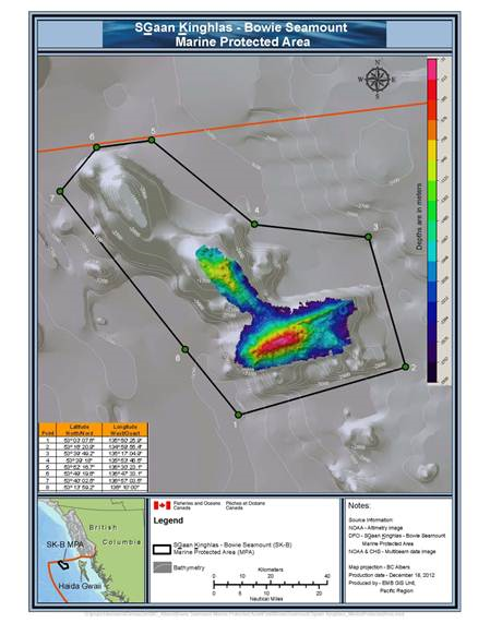
.png)
Last updated: 2026-06-09
- Date modified: