
BC tidal area 12 - Port Hardy, Robson Bight: Bivalve shellfish contamination information
Eating contaminated shellfish can make you very sick and can even be life threatening.
Harvesting opportunities and closures change often throughout the year for conservation or public health reasons. Check the table below or our real-time bivalve shellfish safety harvesting map to ensure that it's legal and safe to harvest, every time you head out to fish. If you are a recreational harvester, you also need to review recreational shellfish harvesting opportunities and limits and ensure you are carrying a current tidal waters sport fishing licence.
Because of the risk of sanitary contamination, all bivalve shellfish harvesting is permanently closed within the following boundaries, often marked with signage or red concrete markers:
- 300 :metres around industrial, municipal and sewage treatment plant outfall discharges
- 125 :metres around a marina, ferry wharf, floating living accommodation, or any finfish net pen
If you are in an aquaculture facility there are some exceptions to the second item.
- 25 :metres around any floating living accommodation facility located within a shellfish aquaculture facility where a zero-discharge and appropriate waste management plan is a condition of the Aquaculture Licence and is approved by the Regional Interdepartmental Committee
- 0 :metres of any finfish net pen within an aquaculture facility where an Integrated Multi-Trophic Aquaculture Management Plan approved by the Regional Interdepartmental Committee is in operation.
Shellfish aquaculture facilities use markers at the corners of their licensed area.
Bivalve shellfish contamination status
Look at the first column below to see which species are safe to harvest. If there is information in the second column, it is both illegal and unsafe to harvest any bivalve species in those areas.
| Subarea | Marine biotoxin update (open bivalve species) | Sanitary contamination closures (closed to shellfish harvesting) |
|---|---|---|
| 12-1 | Closed to All Bivalve Species | |
| 12-2 | Closed to All Bivalve Species | |
| 12-3 | Closed to All Bivalve Species | |
| 12-4 | Closed to All Bivalve Species | |
| 12-5 | Closed to All Bivalve Species | |
| 12-6 | Geoduck;Clam - Horse | |
| 12-7 | Closed to All Bivalve Species | |
| 12-8 | Closed to All Bivalve Species | |
| 12-9 | Closed to All Bivalve Species | |
| 12-10 | Closed to All Bivalve Species | |
| 12-11 | Closed to All Bivalve Species | |
| 12-12 | Closed to All Bivalve Species | |
| 12-13 | ||
| 12-14 | Closed to All Bivalve Species | |
| 12-15 | Closed to All Bivalve Species | |
| 12-16 | Geoduck;Clam - Horse | |
| 12-17 | Geoduck;Clam - Horse | |
| 12-18 | Closed to All Bivalve Species | |
| 12-19 | Closed to All Bivalve Species | |
| 12-20 | Closed to All Bivalve Species | |
| 12-21 | Closed to All Bivalve Species | |
| 12-22 | Closed to All Bivalve Species | |
| 12-23 | Closed to All Bivalve Species | |
| 12-24 | Closed to All Bivalve Species | |
| 12-25 | Closed to All Bivalve Species | |
| 12-26 | Closed to All Bivalve Species | |
| 12-27 | Closed to All Bivalve Species | |
| 12-28 | Closed to All Bivalve Species | |
| 12-29 | Closed to All Bivalve Species | |
| 12-30 | Closed to All Bivalve Species | |
| 12-31 | Closed to All Bivalve Species | |
| 12-32 | Closed to All Bivalve Species | |
| 12-33 | Closed to All Bivalve Species | |
| 12-34 | Closed to All Bivalve Species | |
| 12-35 | Closed to All Bivalve Species | |
| 12-36 | Closed to All Bivalve Species | |
| 12-37 | Closed to All Bivalve Species | |
| 12-38 | Closed to All Bivalve Species | |
| 12-39 | ||
| 12-40 | Closed to All Bivalve Species | |
| 12-41 | Closed to All Bivalve Species | |
| 12-42 | Closed to All Bivalve Species | |
| 12-43 | Closed to All Bivalve Species | |
| 12-44 | Closed to All Bivalve Species | |
| 12-45 | Closed to All Bivalve Species | |
| 12-46 | Closed to All Bivalve Species | |
| 12-47 | Closed to All Bivalve Species | |
| 12-48 | Closed to All Bivalve Species |
Last updated: 2026-07-23
Area descriptions
| Closure | Map | Area description |
|---|---|---|
| 12.1 Hardy Bay | 12.1.png | That portion of Hardy Bay lying inside a straight line drawn from Daphne Point on the east side of Hardy Bay to the prominent point of land just north of Scotia Bay at 50°44.83' north latitude and 127°29.68' west longitude. [NAD83] |
| 12.10 Little Nimmo Bay | 12.10.png | The waters and intertidal foreshore of Little Nimmo Bay located east of a line drawn from the headland on the south side of the bay at 50°56.30' north latitude and 126°41.25' west longitude, thence northerly to a point on the northern shore at 50°56.40' north latitude and 126°41.25' west longitude. [NAD83] |
| 12.12 Sutherland Bay, Drury Inlet | 12.12.png | The waters and intertidal foreshore of the southwestern head of Sutherland Bay, Drury Inlet, located inside a line drawn from the rock shoal on the southern foreshore, thence to the rock shoal on the northern foreshore. [NAD83] |
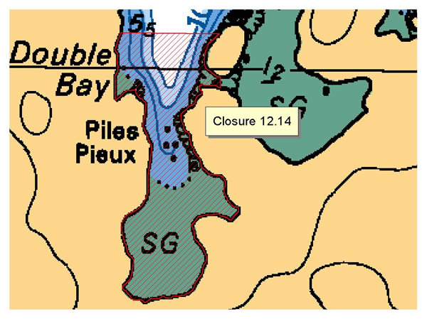
| 12.14 Double Bay, Hanson Island | 12.14.png | The waters and intertidal foreshore of the western bay of Double Bay, Hanson Island, lying inside a line drawn from a point on shore 200 m north of the Double Bay resort due east to an unnamed island and from the southernmost tip of the unnamed island due south to the opposite shore. [NAD83] |
| 12.15 Alert Bay, Cormorant Island | 12.15.png | The waters and intertidal foreshore of Alert Bay, Cormorant Island, inside a line drawn from the navigational light at Yellow Bluff, thence southeast to the cable crossing sign at 50°34.65' north latitude and 126°55.30' west longitude, thence eastward along the foreshore of Gordon Bluff to the end of Fir Street. [NAD83] |
| 12.16 North Side, Cormorant Island | 12.16.png | The waters and intertidal foreshore of Cormorant Island and Cormorant Channel inside a line commencing at the westernmost point of Cormorant Island at 50°35.62' north latitude and 126°57.54' west longitude thence due north to the parallel passing through 50°36.50' north latitude, thence due east to a point in water at 50°36.50' north latitude and 126°54.33' west longitude, thence due south to the foot of Fir St. on Cormorant Island at 50°34.74' north latitude and 126°54.33' west longitude. [NAD83] |
| 12.17 Clam Cove, Nigei Island | 12.17.png | The waters and intertidal foreshore of a bay locally known as Clam Cove, on Nigei Island, lying inside a line drawn from the north side at 50º52.20' north latitude and 127º40.35' west longitude thence easterly to a point on land at 50º52.15' north latitude and 127º40.29' west longitude. [NAD83] |
| 12.2 Echo Bay, Gilford Island | 12.2.png | The waters and intertidal foreshore of Echo Bay, Gilford Island, lying within 300 m of any part of the boat moorage. [NAD83] |
| 12.21 Dixon Island | 12.21.png | The waters and intertidal foreshore of the unnamed bay on the north-easterly shore of Dickson Island, lying inside of a line drawn from a point on land at 50°50.33' north latitude and 126°55.58' west longitude, thence southerly to a point on land at 50°50.22' north latitude and 126°55.60' west longitude. [NAD83] |
| 12.22 Shushartie Bay | 12.22.png | The waters and intertidal foreshore of Shushartie Bay at the northern end of Vancouver Island, inside of a line drawn across the mouth of the bay from a point on land located at 50°51.71' north latitude and 127°52.24' west longitude thence southeasterly to a point on land at 50°51.29' north latitude and 127°51.32' west longitude. [NAD83] |
| 12.25 Duval Island | 12.25.png | The waters and intertidal foreshore of the unnamed bay west of Duval Island, lying west of a line commencing from a point of land at 50°46.28' north latitude and 127°30.64' west longitude, thence southeasterly to a point of land on the west side of Duval Island at 50°46.20' north latitude and 127°30.51' west longitude, and thence due south to a point on land at 50°46.11' north latitude and 127°30.51' west longitude. [NAD83] |
| 12.26 Lagoon Cove | 12.26.png | The waters and intertidal foreshore of Lagoon Cove, north of a line drawn from the southernmost point of Farquharson Island at 50°35.57' north latitude and 126°18.73' west longitude true east to a point of land on East Cracroft Island at 50°35.57' north latitude and 126°18.54' west longitude; and southeast of a line drawn from a point of land at 50°36.07' north latitude and 126°18.86' west longitude in a southwesterly direction to a point of land at the northern entrance to the unnamed cove on the east side of Farquharson Island at 50°35.91' north latitude and 126°19.18' west longitude. [NAD83] |
| 12.27 Keogh River | 12.27.png | The waters and intertidal foreshore at the mouth of the Keogh River, from a fishing boundary sign west of the river mouth at 50°40.75' north latitude and 127°21.18' west longitude, thence southeasterly to a point on land east of the mouth of the river mouth at 50°40.59' north latitude and 127°20.64' west longitude. [NAD83] |
| 12.28 Port Harvey, East Cracroft Island | 12.28.png | The waters and intertidal foreshore of Port Harvey, West Cracroft Island, inside a line drawn from the point of land on the southern shore at the eastern entrance to Cracroft Inlet at 50°34.06' north latitude and 126°16.50' west longitude, thence southeasterly to a debris pile on the western shore of Range Island at 50°33.84' north latitude and 126°16.28' west longitude, thence southwesterly to a point of land south of Tide Pole Islet at 50°33.54' north latitude and 126°16.72' west longitude, thence northerly along the intertidal foreshore to the commencement point. [NAD83] |
| 12.3 Beaver Harbour | 12.3.png | The waters and intertidal foreshore of Beaver Harbour, near Port Hardy, lying inside a straight line drawn from Thomas Point through Cormorant Rock to the shore of Vancouver Island, but not including the small unnamed island immediately to the south of Shell Island. [NAD83] |
| 12.30 Dickson Island | 12.30.png | The intertidal foreshore of southwestern Dickson Island inside a line drawn from a point on land at 50°50.10' north latitude and 126°56.69' west longitude, thence southeasterly to a point of land at 50°50.01' north latitude and 126°56.49' west longitude. [NAD83] |
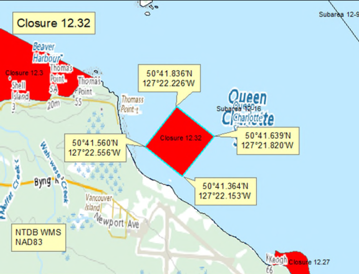
| 12.32 Port Hardy Airport | 12.32.png | Those portions of Subarea 12-16 seaward of the Port Hardy Airport inside a line drawn from a point in the water at 50°41.560' north latitude and 127°22.556' west longitude, thence northeasterly to a point in the water at 50°41.836' north latitude and 127°22.226' west longitude, thence southeasterly to a point in the water at 50°41.639' north latitude and 127°21.820' west longitude, thence southwesterly to a point in the water at 50°41.364' north latitude and 127°22.153' west longitude, thence northwesterly back to the point of commencement. [NAD 83] |
| 12.33 West side of Forward Bay, West Cracroft Island | 12.33.png | The waters and intertidal foreshore of the west side of Forward Bay on West Cracroft Island, inside a line drawn from a point on land at 50°31.27' north latitude and 126°24.42' west longitude, thence southwesterly to a point of land at 50°30.99' north latitude and 126°24.96' west longitude. [NAD83] |
| 12.35 A portion of Clio Channel | 12.35.png | The waters and intertidal foreshore of the channel lying southwest of a line between Farquharson and Dorman Islands in Clio Channel drawn from a point of land on the northern tip of Farquharson Island at 50°36.11' north latitude and 126°19.50' west longitude, thence northwesterly to a point of land on the northeast side of Dorman Island at 50°36.20' north latitude and 126°19.86' west longitude, thence following the high tide mark southwesterly to and across the isthmus between the two islands and back northeasterly to the point of commencement. [NAD83] |
| 12.5 Hopetown Passage, Watson Island | 12.5.png | The waters and intertidal foreshore of Hoy Bay, Watson Island, lying north of a line drawn from Hopetown Point on Watson Island at 50°55.21' north latitude and 126°50.17' west longitude to an unnamed point on Watson Island at 50°55.25' north latitude and 126°49.30' west longitude. [NAD83] |
| 12.6 Macgowan Bay, Drury Inlet | 12.6.png | The waters and intertidal foreshore of Macgowan Bay, Drury Inlet, lying inside a line drawn from a point on shore at 50°54.82' north latitude and 127°08.72' west longitude, thence southeasterly to 50°54.65' north latitude and 127°08.40' west longitude on the opposite shore. [NAD83] |
| 12.7 Bay West of Everard Islets, Drury Inlet | 12.7.png | The waters and intertidal foreshore of a small unnamed bay, immediately west of the Everard Islets, Drury Inlet, lying inside a line drawn from a point on shore at 50°53.38' north latitude and 127°02.83' west longitude, thence easterly to a point on shore at 50°53.36' north latitude and 127°02.58' west longitude. [NAD83] |
| 12.8 Shoal Harbour, Gilford Island | 12.8.png | The waters and intertidal foreshore of Shoal Harbour, Gilford Island, lying inside a line drawn from a point on the west shore at 50°44.59' north latitude and 126°30.30' west longitude thence easterly to a point on shore at 50°44.59' north latitude and 126°30.12' west longitude. [NAD83] |
| 12.A Cutter Cove | 12.A.png | The waters and intertidal foreshore of that portion of Subarea 12-26 inside a line the commences at 50°37.052'N, 126°16.501'W [Cutter Cove], then following the shoreline easterly to 50°36.781'N, 126°16.529'W [Cutter Cove], then northerly to the point of commencement. [NAD83] |
| 12.jj Port Harvey | 12.jj.png | Harvesting of bivalve shellfish is prohibited in the waters and intertidal foreshore of Port Harvey inside a line drawn from Harvey Point at 50°32.09' north latitude and 126°16.64' west longitude, thence due west to the point on land on West Cracroft Island at 50°32.09' north latitude and 126°18.16' west longitude, thence northeasterly following the shoreline to the point on land at 50°34.10' north latitude and 126°16.52' west longitude, thence north to the point on land on East Cracroft Island at 50°34.13' north latitude and 126°16.51' west longitude, thence following the shoreline back to the point of commencement. [NAD83]. |
| 12-13.A | 12-13.A.png | The waters and intertidal foreshore of that portion of Subarea 12-13 west of a line drawn at 50°55.029' N 127°21.956' W then south intersecting the boundary with Subarea 12-7 at 50°52.317' N 127°21.956' W. [NAD 83] |
| 12-13.B | 12-13.B.png | The waters and intertidal foreshore of that portion of Subarea 12-13 east of a line drawn at 50°55.029' N 127°21.956' W then south intersecting the boundary with Subarea 12-7 at 50°52.317' N 127°21.956' W. [NAD 83] |
| 12-39.A | 12-39.A.png | That portion of Subarea 12-39 North of a line drawn at Sharp Point on Broughton Island at (50° 47.467'N, 126° 36.090' W) proceeding westerly down Fife Sound into Nowell Channel intersecting the boundary with PFMA 12-7 at (50° 45.006' N, 126° 47.224' W). |
| 12-39.B | 12-39.B.png | That portion of Subarea 12-39 South of a line drawn at Sharp Point on Broughton Island at (50° 47.467'N, 126° 36.090' W) proceeding westerly down Fife Sound into Nowell Channel intersecting the boundary with PFMA 12-7 at (50° 45.006' N, 126° 47.224' W). |
Last updated: 2026-07-23
Related links
- Area maps
- Realtime bivalve shellfish safety harvesting map
- Information about recreational shellfish harvesting in BC
- Shellfish harvesting safety information
- Planned bivalve shellfish harvesting closures
- Identify your catch
Contact us
Email: DFO.PACCSSP-PCAMPAC.MPO@dfo-mpo.gc.ca
- Date modified: