
BC tidal area 13 - Campbell River, Cortes Island, Quadra Island, Sonora Island: Bivalve shellfish contamination information
Eating contaminated shellfish can make you very sick and can even be life threatening.
Harvesting opportunities and closures change often throughout the year for conservation or public health reasons. Check the table below or our real-time bivalve shellfish safety harvesting map to ensure that it's legal and safe to harvest, every time you head out to fish. If you are a recreational harvester, you also need to review recreational shellfish harvesting opportunities and limits and ensure you are carrying a current tidal waters sport fishing licence.
Because of the risk of sanitary contamination, all bivalve shellfish harvesting is permanently closed within the following boundaries, often marked with signage or red concrete markers:
- 300 metres around industrial, municipal and sewage treatment plant outfall discharges
- 125 metres around a marina, ferry wharf, floating living accommodation, or any finfish net pen
If you are in an aquaculture facility there are some exceptions to the second item.
- 25 metres around any floating living accommodation facility located within a shellfish aquaculture facility where a zero-discharge and appropriate waste management plan is a condition of the Aquaculture Licence and is approved by the Regional Interdepartmental Committee
- 0 metres of any finfish net pen within an aquaculture facility where an Integrated Multi-Trophic Aquaculture Management Plan approved by the Regional Interdepartmental Committee is in operation.
Shellfish aquaculture facilities use markers at the corners of their licensed area.
Bivalve shellfish contamination status
Look at the first column below to see which species are safe to harvest. If there is information in the second column, it is both illegal and unsafe to harvest any bivalve species in those areas.
| Subarea | Marine biotoxin update (open bivalve species) | Sanitary contamination closures (closed to shellfish harvesting) |
|---|---|---|
| 13-1 | Clam - Littleneck;Clam - Manila;Mussels - all species combined;Oyster - Pacific;Scallop - Pink;Scallop - Spiny | |
| 13-2 | Clam - Littleneck;Clam - Manila;Mussels - all species combined;Oyster - Pacific;Scallop - Pink;Scallop - Spiny | |
| 13-3 | Closed to All Bivalve Species | |
| 13-4 | Closed to All Bivalve Species | |
| 13-5 | Closed to All Bivalve Species | |
| 13-6 | Closed to All Bivalve Species | |
| 13-7 | Closed to All Bivalve Species | |
| 13-8 | Closed to All Bivalve Species | |
| 13-9 | Closed to All Bivalve Species | |
| 13-10 | Closed to All Bivalve Species | |
| 13-11 | Closed to All Bivalve Species | |
| 13-12 | Clam - Littleneck;Clam - Manila;Mussels - all species combined;Oyster - Pacific;Scallop - Pink;Scallop - Spiny | |
| 13-13 | Clam - Littleneck;Clam - Manila;Mussels - all species combined;Oyster - Pacific | |
| 13-14 | Clam - Littleneck;Clam - Manila;Mussels - all species combined;Oyster - Pacific | |
| 13-15 | Clam - Butter;Clam - Littleneck;Clam - Manila;Mussels - all species combined;Oyster - Pacific;Scallop - other;Scallop - Pacific;Scallop - Pink;Scallop - Spiny | |
| 13-16 | Clam - Littleneck;Clam - Manila;Mussels - all species combined;Oyster - Pacific | |
| 13-17 | Cockles;Clam - Littleneck;Clam - Manila;Mussels - all species combined;Oyster - Pacific | |
| 13-18 | Closed to All Bivalve Species | |
| 13-19 | Closed to All Bivalve Species | |
| 13-20 | Closed to All Bivalve Species | |
| 13-21 | Closed to All Bivalve Species | |
| 13-22 | Closed to All Bivalve Species | |
| 13-23 | Closed to All Bivalve Species | |
| 13-24 | Closed to All Bivalve Species | |
| 13-25 | Closed to All Bivalve Species | |
| 13-26 | Closed to All Bivalve Species | |
| 13-27 | Closed to All Bivalve Species | |
| 13-28 | Closed to All Bivalve Species | |
| 13-29 | Closed to All Bivalve Species | |
| 13-30 | Closed to All Bivalve Species | |
| 13-31 | Closed to All Bivalve Species | |
| 13-32 | Closed to All Bivalve Species | |
| 13-33 | Closed to All Bivalve Species | |
| 13-34 | Closed to All Bivalve Species | |
| 13-35 | Closed to All Bivalve Species | |
| 13-36 | Closed to All Bivalve Species | |
| 13-37 | Closed to All Bivalve Species | |
| 13-38 | Closed to All Bivalve Species | |
| 13-39 | Closed to All Bivalve Species | |
| 13-40 | Closed to All Bivalve Species | |
| 13-41 | Closed to All Bivalve Species | |
| 13-42 | Closed to All Bivalve Species | |
| 13-43 | Closed to All Bivalve Species |
Last updated: 2026-06-09
Area descriptions
| Closure | Map | Area description |
|---|---|---|
| 13.10 Whaletown Bay, Cortez Island | 13.10.png | The waters and intertidal foreshore at the head of Whaletown Bay, Cortes Island lying east of a line drawn from a point of land on the north shore located at 50°06.59' north latitude and 125°02.90' west longitude thence southerly to a point of land on the opposite shore located at 50°06.55' north latitude and 125°02.90' west longitude. [NAD83] |
| 13.11 Coulter Bay, Cortez Island | 13.11.png | The waters and intertidal foreshore of Coulter Bay, Cortes Island, lying inside a line drawn from the northeastern point of the unnamed island in the bay due east to the nearest point of land and from the northwestern side of the unnamed island southwest to the nearest point of land. [NAD83] |
| 13.12 Phillips Arm | 13.12.png | The waters and intertidal foreshore of Phillips Arm, inside a line drawn from Bullveke Point on the western shore of Phillips Arm, thence southeasterly to Richard Point on the eastern shore of Phillips Arm. [NAD83] |
| 13.14 Gray Creek, Loughborough Inlet | 13.14.png | The waters and intertidal foreshore around Gray Creek, Loughbourough Inlet, lying inside a line north of Gray Creek drawn from 50°32.45' north latitude and 125°31.80' west longitude thence southerly to the east end of a small islet at 50°32.21' north latitude and 125°32.05' west longitude thence easterly to a point on land at 50°32.02' north latitude and 125°31.90' west longitude. [NAD83] |
| 13.15 Bessborough Bay | 13.15.jpeg | The waters and intertidal foreshore of a small bay at the north end of Bessborough Bay lying inside a line drawn from the north of the entrance of the bay at 50º29.42' north latitude and 125º46.64' west longitude and thence southeasterly to a point on land at 50º29.25' north latitude and 125º46.42' west longitude. [NAD83] |
| 13.16 Jackson Bay, Topaze Harbour | 13.16.png | The intertidal foreshore of Jackson Bay, in northwestern Topaze Harbour between Neale Point and Molesworth Point. [NAD83] |
| 13.17 Topaze Harbour Head | 13.17.png | All of the intertidal foreshore of the easternmost head of Topaze Harbour between Haswell Point and a point on land easterly of Hill Pont at 50°31.10' north latitude and 125°44.35' west longitude. [NAD83] |
| 13.19 Granite Bay | 13.19.png | The waters and intertidal foreshore of eastern Granite Bay, Quadra Island east of a line drawn from a point of land west of a private dock at 50°14.42' north latitude and 125°18.68' west longitude, thence in a true north direction to a point on land on the opposite shore at 50°14.50' north latitude and 125°18.68' west longitude. [NAD83] |
| 13.2 Heriot Bay, Quadra Island | 13.2.png | Those portions of Subarea 13-13 in Heriot Bay, lying inside a line drawn from a point on land at 50°06.396' north latitude and 125°13.144' west longitude, thence northeast to a point of land at 50°06.521' north latitude and 125°12.895' west longitude, thence southeast to a point in the water at 50°06.282' north latitude and 125°12.296' west longitude, thence southwest to a point on land at 50°06.226' north latitude and 125°12.446' west longitude, thence northwesterly to the point of commencement. [NAD 83] |
| 13.20 Gorge Harbour | 13.20.png | The waters and intertidal foreshore of an unnamed cove in eastern Gorge Harbour, Cortes Island, south of a line drawn from a point on land at 50°05.75' north latitude and 124°58.95' west longitude, thence in a straight line northwesterly to the most northerly point of land on the opposite shore at 50°05.80' north latitude and 124°59.05' west longitude. [NAD83] |
| 13.23 Church House, Calm Channel | 13.23.png | The waters and intertidal foreshore of the unnamed cove fronting the Church House Indian Reserve located on Calm Channel, east of a line drawn from the unnamed point of land at 50°20.12' north latitude and 125°04.71' west longitude, thence in a southerly direction to a point of land at the log dump at 50°19.91' north latitude and 125°04.66' west longitude. [NAD83] |
| 13.24 A portion of Discovery Passage | 13.24.png | The waters and intertidal foreshore of Discovery Passage south of a line drawn between a point of land on Vancouver Island at 50°06.896' north latitude and 125°20.593' west longitude, thence northeasterly to a point on land on Quadra Island at 50°07.697' north latitude and 125°18.561' west longitude, and north of a line from a point on land on Vancouver Island at 49°58.673' north latitude and 125°13.246' west longitude, thence northeasterly to a point on land on Quadra Island at 49°59.692' north latitude and 125°11.183' west longitude. [NAD83] |
| 13.27 Southwest Gorge Harbour, Cortes Island | 13.27.png | The waters and intertidal foreshore of southwest Gorge Harbour, Cortes Island lying southwest of a line drawn from a point on land at the northern edge of a shoal at 50°05.73' north latitude and 125°01.50' west longitude, thence southeasterly to a point on land at the eastern end of a shoal at 50°05.58' north latitude and 125°01.31' west longitude. [NAD83] |
| 13.28 Whaletown Bay, Cortes Island | 13.28.png | The waters and intertidal foreshore of Whaletown Bay east of a line drawn from a point on land on Cortes Island at 50°06.567' north latitude and 125°03.377' west longitude southeasterly to a point on land at 50°06.409' north latitude and 125°03.175' west longitude, and west of a line drawn from a point on land at 50°06.528' north latitude and 125°02.957' west longitude northwesterly to a point on land at 50°06.633' north latitude and 125°03.115' west longitude. [NAD83] |
| 13.3 A portion of Discovery Passage to Kuhushan Point | 13.3.png | The intertidal foreshore of southern Discovery Passage, from the southern Campbell River Harbour limit, located at 49°59.69' north latitude and 125°13.71' west longitude, thence southeasterly to the spit located west of Kuhushan Point at 49°53.92' north latitude and 125°09.11' west longitude. [NAD83] |
| 13.6 Big Bay, Stuart Island | 13.6.png | The waters and intertidal foreshore of Big Bay, Stuart Island lying inside a straight line drawn from Hesler Point to Whirlpool Point. [NAD83] |
| 13.7 Kelsey Bay and Salmon Bay | 13.7.png | The waters and intertidal foreshore of Kelsey Bay and Salmon Bay lying inside a straight line drawn from the northern headland of Brasseau Bay through the Peterson Islet navigation beacon to a point on Vancouver Island. [NAD83] |
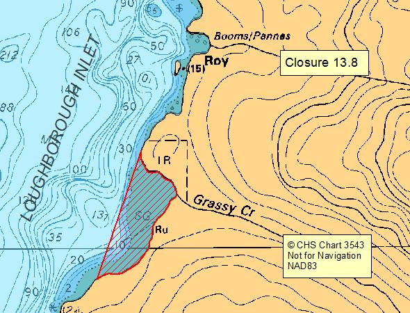
| 13.8 Grassy Creek, Loughborough Inlet | 13.8.png | The waters and intertidal foreshore of Loughborough Inlet lying inside a line drawn between the two headlands of the unnamed bay at the mouth of Grassy Creek. [NAD83] |
| 13.9 Forward Harbour | 13.9.png | All of the intertidal foreshore of the head of Forward Harbour between a point on land east of Blanche Point at 50°29.45' north latitude and 125°42.45' west longitude and a point on land east of Cust Point at 50°29.12' north latitude and 125°42.10' west longitude. [NAD83] |
| 13.B Von Donop Inlet, Cortes Island | 13.B.png | The waters and intertidal foreshore of that portion of Subarea 13-17 inside a line that commences at 50°10.962'N, 124°58.640'W [Von Donop Inlet, Cortes Island], then following the shoreline southeasterly to 50°10.887'N, 124°58.835'W [Von Donop Inlet, Cortes Island], then northeasterly to the point of commencement. [NAD83] |
| 13.C Drew Harbour, Quadra Island | 13.C.png | The waters and intertidal foreshore of that portion of Subarea 13-13 inside a line that commences at 50°06.463'N, 125°11.811'W [Rebecca Spit, Drew Harbour, Quadra Island], then following the shoreline southerly to 50°06.226'N, 125°12.446'W [Drew Harbour, Quadra Island], then northeasterly to the point of commencement. [NAD83] |
| 13.F Western Gorge Harbour, Cortes Island | 13.F.png | The waters and intertidal foreshore of western Gorge Harbour, Cortes Island lying west of a line drawn from the base of the marina boat ramp at 50°06.04' north latitude and 125°01.45' west longitude, thence in a southwesterly direction to a point of land on the opposite shore at 50°05.93' north latitude and 125°01.72' west longitude during the period July 1 to September 15 each year. [NAD 83] |
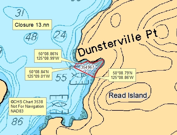
| 13.nn west of Read Island, Hoskyn Channel, Landfile #0354967, oysters only | 13.nn.png | The waters and intertidal foreshore of that portion of Subarea 13-13 inside a line that commences at 50°8.859'N and 125°8.990'W [on land] then following the shoreline to 50°8.791'N and 125°8.857'W [on land] then in a straight line to 50°8.840'N and 125°9.009'W [in water] then in a straight line to the point of commencement; including BC Land Registry Aquaculture Tenure #0354967. [NAD83] |
Last updated: 2026-06-09
Related links
- Area maps
- Realtime bivalve shellfish safety harvesting map
- Information about recreational shellfish harvesting in BC
- Shellfish harvesting safety information
- Planned bivalve shellfish harvesting closures
- Identify your catch
Contact us
Email: DFO.PACCSSP-PCAMPAC.MPO@dfo-mpo.gc.ca
- Date modified: