
BC tidal area 14 - Comox, Denman Island, Hornby Island, Parksville: Bivalve shellfish contamination information
Eating contaminated shellfish can make you very sick and can even be life threatening.
Harvesting opportunities and closures change often throughout the year for conservation or public health reasons. Check the table below or our real-time bivalve shellfish safety harvesting map to ensure that it's legal and safe to harvest, every time you head out to fish. If you are a recreational harvester, you also need to review recreational shellfish harvesting opportunities and limits and ensure you are carrying a current tidal waters sport fishing licence.
Because of the risk of sanitary contamination, all bivalve shellfish harvesting is permanently closed within the following boundaries, often marked with signage or red concrete markers:
- 300 metres around industrial, municipal and sewage treatment plant outfall discharges
- 125 metres around a marina, ferry wharf, floating living accommodation, or any finfish net pen
If you are in an aquaculture facility there are some exceptions to the second item.
- 25 metres around any floating living accommodation facility located within a shellfish aquaculture facility where a zero-discharge and appropriate waste management plan is a condition of the Aquaculture Licence and is approved by the Regional Interdepartmental Committee
- 0 metres of any finfish net pen within an aquaculture facility where an Integrated Multi-Trophic Aquaculture Management Plan approved by the Regional Interdepartmental Committee is in operation.
Shellfish aquaculture facilities use markers at the corners of their licensed area.
Bivalve shellfish contamination status
Look at the first column below to see which species are safe to harvest. If there is information in the second column, it is both illegal and unsafe to harvest any bivalve species in those areas.
| Subarea | Marine biotoxin update (open bivalve species) | Sanitary contamination closures (closed to shellfish harvesting) |
|---|---|---|
| 14-1 | Clam - Littleneck;Clam - Manila;Mussels - all species combined;Oyster - Pacific | |
| 14-2 | Clam - Littleneck;Clam - Manila;Mussels - all species combined;Oyster - Pacific | |
| 14-3 | Geoduck;Clam - Horse;Mussels - all species combined | |
| 14-4 | Clam - Littleneck;Clam - Manila;Mussels - all species combined;Oyster - Pacific | |
| 14-5 | Clam - Littleneck;Clam - Manila;Mussels - all species combined;Oyster - Pacific;Scallop - other;Scallop - Pacific;Scallop - Pink;Scallop - Spiny | |
| 14-6 | Closed to All Bivalve Species | |
| 14-7 | Clam - Littleneck;Clam - Manila;Mussels - all species combined;Oyster - Pacific | |
| 14-8 | Clam - Littleneck;Clam - Manila;Clam - Varnish;Mussels - all species combined;Oyster - Pacific;Scallop - other;Scallop - Pacific;Scallop - Pink;Scallop - Spiny | |
| 14-9 | Clam - Littleneck;Clam - Manila;Mussels - all species combined;Oyster - Pacific | |
| 14-10 | Clam - Littleneck;Clam - Manila;Mussels - all species combined;Oyster - Pacific | |
| 14-11 | Clam - Butter;Clam - Littleneck;Clam - Manila;Mussels - all species combined;Oyster - Pacific | |
| 14-12 | Closed to All Bivalve Species | |
| 14-13 | Clam - Littleneck;Clam - Manila;Mussels - all species combined;Oyster - Pacific | |
| 14-14 | Clam - Littleneck;Clam - Manila;Mussels - all species combined;Oyster - Pacific | |
| 14-15 | Clam - Butter;Clam - Littleneck;Clam - Manila;Clam - Varnish;Mussels - all species combined;Oyster - Pacific;Scallop - other;Scallop - Pacific;Scallop - Pink;Scallop - Spiny |
Last updated: 2026-06-01
Area descriptions
| Closure | Map | Area description |
|---|---|---|
| 13.3 A portion of Discovery Passage to Kuhushan Point | 13.3.png | The intertidal foreshore of southern Discovery Passage, from the southern Campbell River Harbour limit, located at 49°59.69' north latitude and 125°13.71' west longitude, thence southeasterly to the spit located west of Kuhushan Point at 49°53.92' north latitude and 125°09.11' west longitude. [NAD83] |
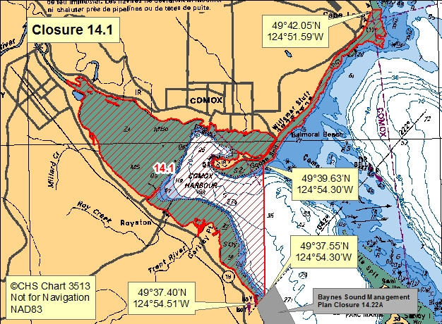
| 14.1 Comox Harbour | 14.1.png | The waters and intertidal foreshore of Comox Harbour lying inside a line drawn from the point on land at the range markers at 49°37.40' north latitude and 124°54.51' west longitude, south of Gartley Point, thence seaward northeasterly to a point in water at 49°37.55' north latitude and 124°54.30' west longitude, thence due north towards the road entrance gate to HMCS Quadra on Goose Spit to a point in water at 49°39.63' north latitude and 124°54.30' west longitude, thence extending northeasterly along the low water mark to the first prominent point of land at the south end of Cape Lazo at 49°42.05' north latitude and 124°51.59' west longitude. [NAD83] |
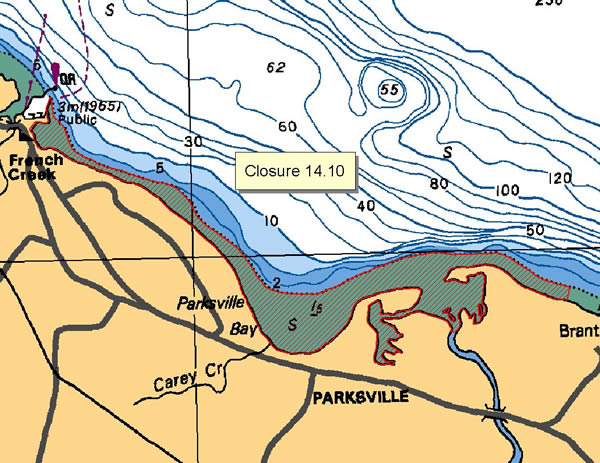
| 14.10 Parksville Bay, Englishman River to French Creek | 14.10.png | The waters and intertidal foreshore of the Englishman River and Parksville Bay to French Creek, starting at a point east of the Englishman River mouth at the Rathtrevor Provincial Park northwest boundary at 49°19.60' north latitude and 124°16.40' west longitude, thence westerly through Parksville Bay to the French Creek marina quick-flashing red beacon. [NAD83] |
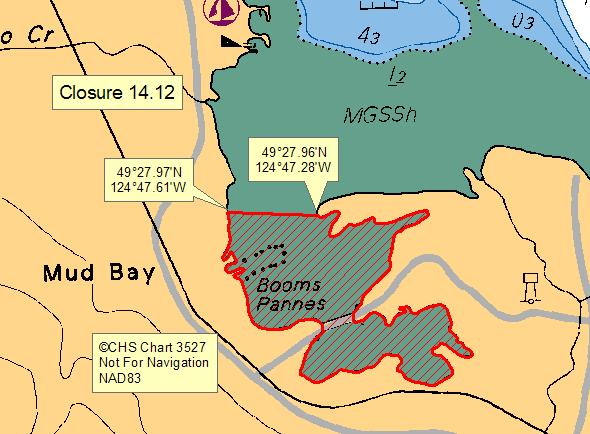
| 14.12 Mud Bay, Baynes Sound | 14.12.png | The waters and intertidal foreshore of Mud Bay lying inside of a line drawn from a point on land from the western shore of Mud Bay at 49°27.97' north latitude and 124°47.61' west longitude thence easterly to a point on the western end of the peninsula of land at 49°27.96' north latitude and 124°47.28' west longitude thence following the southern shoreline highwater mark back to the point of commencement. [NAD83] |
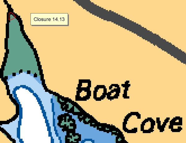
| 14.13 Boat Cove, Lasqueti Island | 14.13.png | The waters and intertidal foreshore which lie within a 50 metre radius of the mouth of the creek at the head of Boat Cove, Lasqueti Island. [NAD83] |
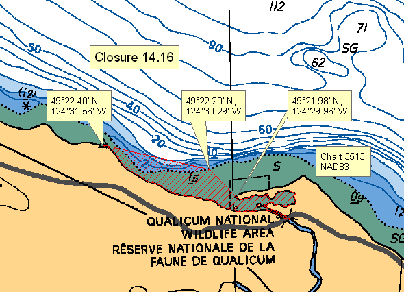
| 14.16 Mouth of Little Qualicum River | 14.16.png | The waters and intertidal foreshore at the mouth of the Little Qualicum River, starting at the tip of the spit at 49°21.98' north latitude and 124°29.96' west longitude thence northwesterly to the low water mark at 49°22.20' north latitude and 124°30.29' west longitude, thence westerly in a straight line to a point of land at 49°22.40' north latitude and 124°31.56' west longitude. [NAD83] |
| 14.17 False Bay, Lasqueti Island | 14.17.png | The waters and intertidal foreshore of the small bay northeast of Higgins Island in False Bay, Lasqueti Island, commencing from the point of land at 49°29.99' north latitude and 124°21.45' west longitude, thence southward to the southeast tip of the small island in the bay, thence eastward to the point of land at 49°29.90' north latitude and 124°21.57' west longitude. [NAD83] |
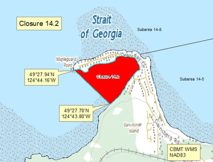
| 14.2 Deep Bay, Baynes Sound | 14.2.png | The waters and intertidal foreshore of Deep Bay Harbour at the southwest end of Baynes Sound lying inside a line drawn from the tip of Mapleguard Point at 49°27.94' north latitude and 124°44.16' west longitude southeasterly to a point on land at 49°27.70' north latitude and 124°43.80' west longitude. [NAD83] |
| 14.21 Kitty Coleman Beach to Little River | 14.21.png | The waters and intertidal foreshore from the boat ramp at Kitty Coleman Beach Provincial Park at 49°47.45' north latitude and 124°59.60' west longitude to the peninsula at the mouth of Little River at 49°44.55' north latitude and 124°55.35' west longitude. [NAD27] |
| 14.27 Comox | 14.27.png | Those portions of Subareas 14-12 and 14-13 inside a line drawn from a point in the water at 49°42.39' north latitude and 124°49.96' west longitude, thence northeasterly to a point in the water at 49°42.59' north latitude and 124°49.32' west longitude, thence southeasterly to a point in the water at 49°41.94' north latitude and 124°48.86' west longitude, thence southwesterly to a point in the water at 49°41.73' north latitude and 124°49.51' west longitude, thence northwesterly back to the point of commencement. [NAD83] |
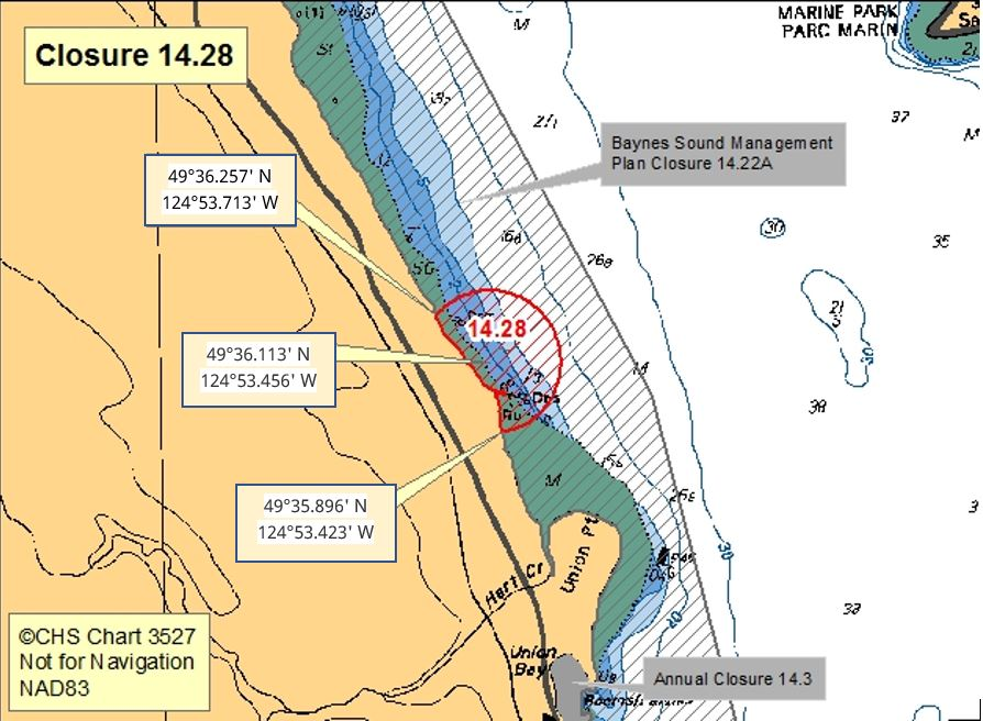
| 14.28 Union Bay, Northwest of Union Point | 14.28.png | The waters and intertidal foreshore within a 400 m radius of a point on land on the east shore of Vancouver Island at 49°36.113' north latitude and 124°53.456' west longitude, north of Union Point. The northwestern boundary is a point on land at 49°36.257' north latitude and 124°53.713' west longitude and the southeastern boundary is a point on land at 49°35.896' north latitude and 124°53.423' west longitude. [NAD 83] |
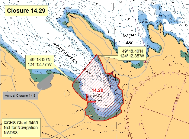
| 14.29 Northwest Bay | 14.29.png | The waters and intertidal foreshore of Northwest Bay lying south of a line drawn from a point of land on the west side of the entrance at 49º18.09' north latitude and 124º12.77' west longitude thence northeasterly to the east side of the entrance to a point of land at 49°18.40' north latitude and 124°12.35' west longitude. [NAD83] |
| 14.3 Union Bay, Baynes Sound | 14.3.png | The intertidal foreshore of Union Bay, Baynes Sound lying west of a line drawn from a point of land on the southern headland of Union Bay at 49°35.13' north latitude and 124°53.01' west longitude southerly to the foot of Tipton Road at 49°34.32' north latitude and 124°52.75' west longitude. [NAD83] |
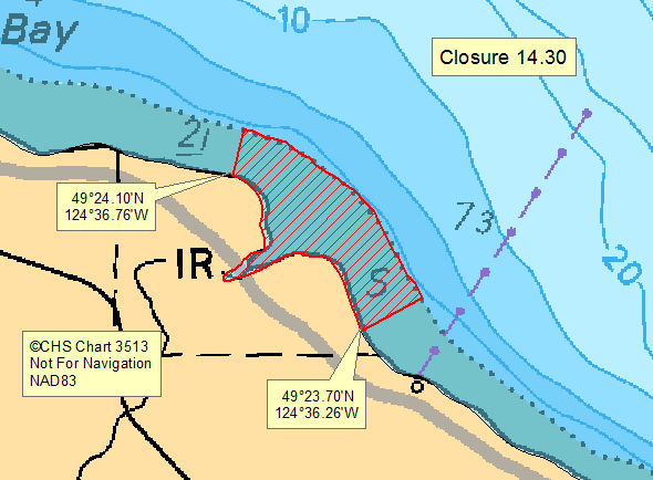
| 14.30 Qualicum River Estuary | 14.30.png | The intertidal foreshore of the Qualicum River Estuary from a point on land at 49°24.10' north latitude and 124°36.76' west longitude, thence southeasterly following the intertidal boundary to a point on land at 49°23.70' north latitude and 124°36.26' west longitude. [NAD83] |
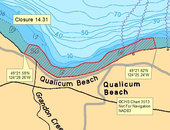
| 14.31 Qualicum Beach | 14.31.png | The intertidal foreshore of Qualicum Beach from a point on land at 49°21.59' north latitude and 124°28.26' west longitude 400 m northwest of the mouth of Grandon Creek following the intertidal boundary easterly to a point on land at 49°21.62' north latitude and 124°25.24' west longitude, 300 m east of the Hall Road Pump Station. [NAD83] |
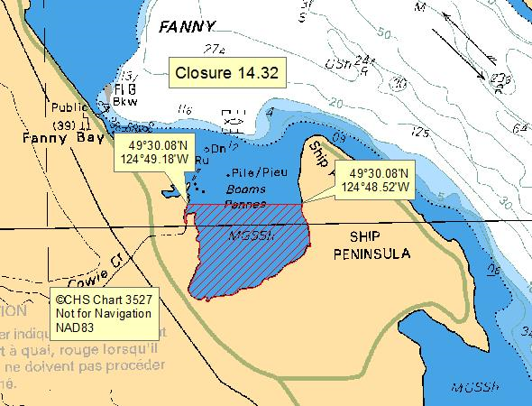
| 14.32 A portion of Fanny Bay, Baynes Sound | 14.32.png | The waters and intertidal foreshore of Fanny Bay south of a line drawn from a point on land within the Fanny Bay Conservation Area at 49°30.08' north latitude and 124°48.52' west longitude, southerly of Ship Point, thence due west to a point on land at 49°30.08' north latitude and 124°49.18' west longitude. [NAD83] |
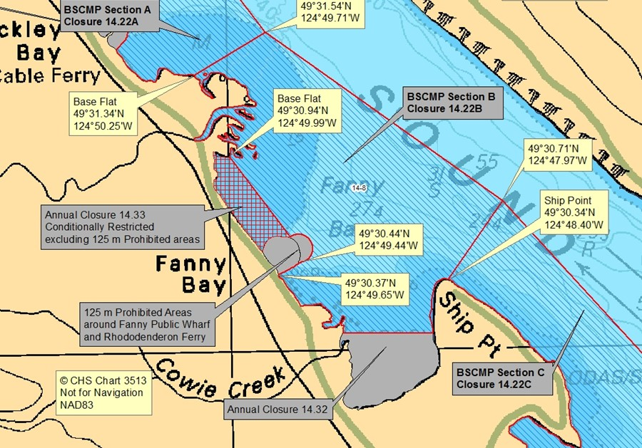
| 14.33 A portion of Fanny Bay, Baynes Sound | 14.33.png | The waters and intertidal foreshore of Fanny Bay lying inside a line drawn from a point on land, 125 m south of the Fanny Bay Public Wharf at 49°30.37' north latitude and 124°49.65' west longitude, thence seaward northeasterly to a point in water at 49°30.44' north latitude and 124°49.44' west longitude, thence northwesterly to a point on land at 49°30.94' north latitude and 124°49.99' west longitude excluding the 125 m Prohibited area around the Fanny Bay Public wharf and Rhododendeeron Ferry. [NAD 83] |
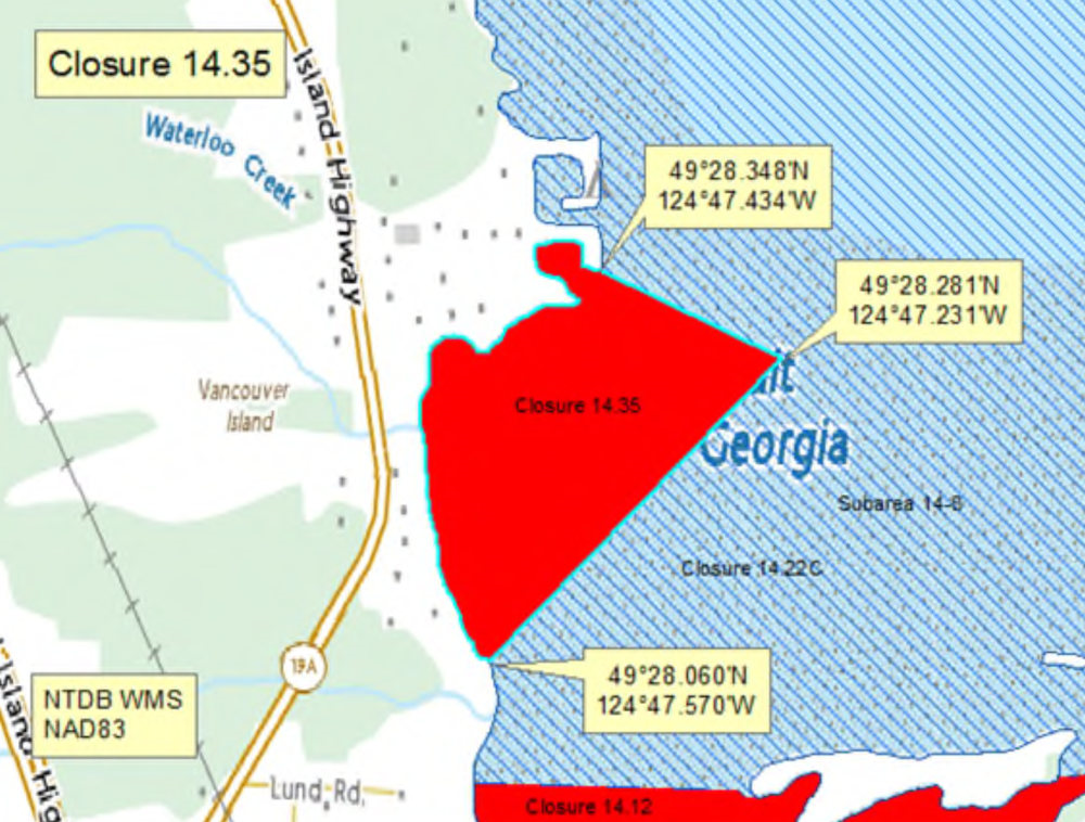
| 14.35 Mud Bay, Waterloo Creek | 14.35.png | The waters and intertidal foreshore of Mud Bay, Baynes Sound lying inside a line drawn from a point on land south of Waterloo Creek at 49°28.060' north latitude and 124°47.570' west longitude, northeasterly to a point in water at 49°28.281' north latitude and 124°47.231' west longitude, thence northwesterly to a point of land at 49°28.348' north latitude and 124°47.434' west longitude thence following the high tide mark southwesterly to the point of commencement. [NAD83] |
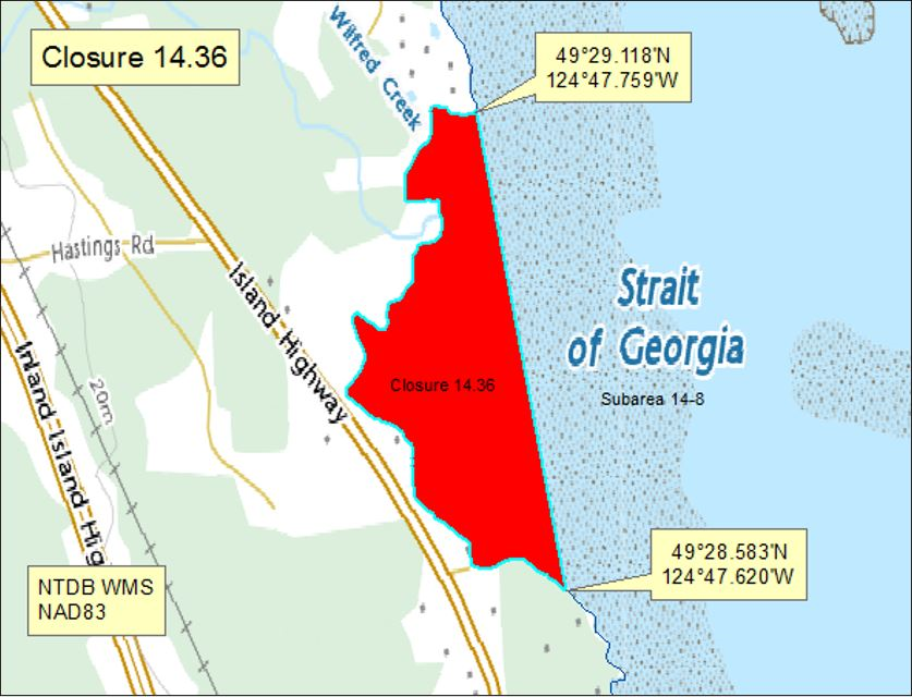
| 14.36 Mud Bay, Baynes Sound | 14.36.png | The waters and intertidal foreshore of Mud Bay, Baynes Sound, lying inside a line drawn from a point of land north of Wilfred Creek at 49°29.118' north latitude and 124°47.759' west longitude, southeast to a point on land at 49°28.583' north latitude and 124°47.620' west longitude thence following the high tide mark north to the point of commencement. [NAD83] |
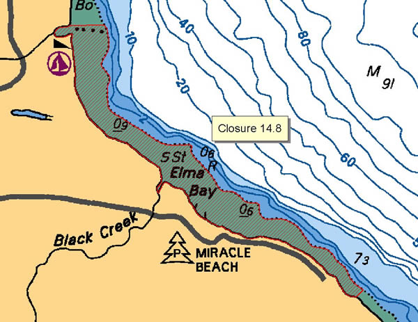
| 14.8 Elma Bay | 14.8.png | The waters and intertidal foreshore of Elma Bay, from the north side of Oyster River at a point at 49°52.35' north latitude and 125°06.90' west longitude to the south end of Elma Beach at a point at 49°50.40' north latitude and 125°03.80' west longitude. [NAD27] |
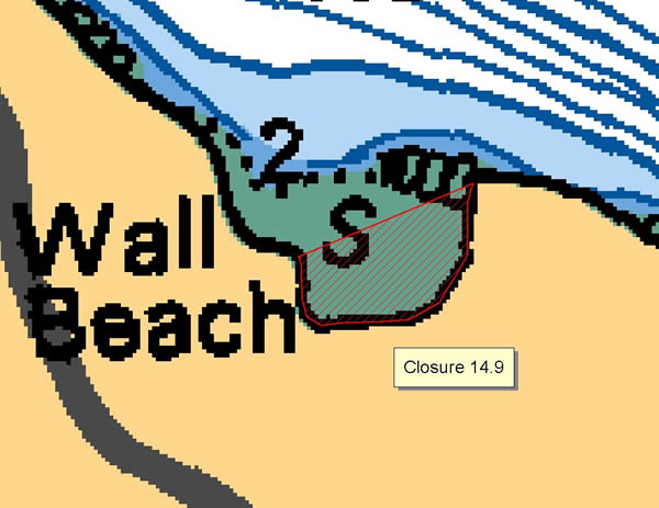
| 14.9 Wall Beach | 14.9.png | The waters and intertidal foreshore of Wall Beach, lying inside a line drawn from a point on the west shore at 49°18.12' north latitude and 124°13.33' west longitude thence easterly to a point on the shore at 49°18.22' north latitude and 124°13.08' west longitude. [NAD83] |
| 14.A Tribune Bay, Hornby Island | 14.A.png | The waters and intertidal foreshore of Tribune Bay, Hornby Island, lying inside of a line from Dunlop Point on the southwest shore at 49°30.58' north latitude and 124°37.87' west longitude thence northeasterly to a point on land at 49°30.97' north latitude and 124°36.39' west longitude. [NAD83] |
| 14.B False Bay, Lasqueti Island | 14.B.png | The waters and intertidal foreshore of False Bay, Lasqueti Island, lying north of a line drawn from a point of land on the southeast side of Higgins Island at 49°29.591' north latitude and 124°21.721' west longitude, thence northeasterly to a point on land on Lasqueti Island at 49°29.638' north latitude and 124°21.341' west longitude, thence following the high tide mark of the Lasqueti Island shoreline beginning in a northerly and westerly direction to point on land at 49°29.728' north latitude and 124°22.160' west longitude, thence southeasterly to a point on land on the northwest side of Higgins Island at 49°29.700' north latitude and 124°22.090' west longitude, thence easterly and southerly following the high tide mark back to the point of commencement. [NAD83] |
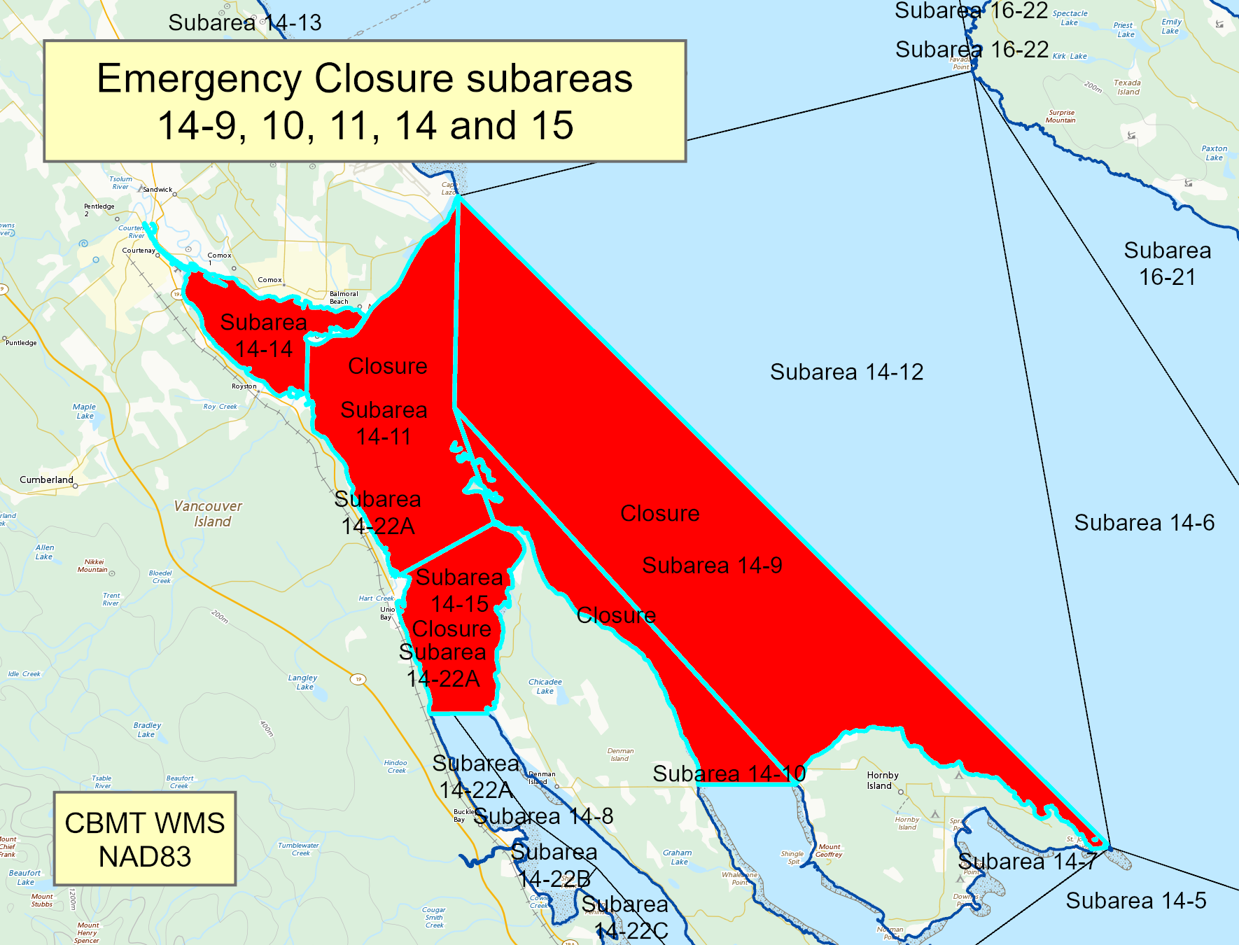
| Comox Valley, Vancouver Island | Comox.png | Pacific Fishery Management Subareas 14-9 to 14-11, 14-14 and 14-15. |
Last updated: 2026-06-01
Related links
- Area maps
- Realtime bivalve shellfish safety harvesting map
- Information about recreational shellfish harvesting in BC
- Shellfish harvesting safety information
- Planned bivalve shellfish harvesting closures
- Identify your catch
Contact us
Email: DFO.PACCSSP-PCAMPAC.MPO@dfo-mpo.gc.ca
- Date modified: