
BC tidal area 16 - Jervis Inlet, Sechelt Inlet, Texada Island: Bivalve shellfish contamination information
Eating contaminated shellfish can make you very sick and can even be life threatening.
Harvesting opportunities and closures change often throughout the year for conservation or public health reasons. Check the table below or our real-time bivalve shellfish safety harvesting map to ensure that it's legal and safe to harvest, every time you head out to fish. If you are a recreational harvester, you also need to review recreational shellfish harvesting opportunities and limits and ensure you are carrying a current tidal waters sport fishing licence.
Because of the risk of sanitary contamination, all bivalve shellfish harvesting is permanently closed within the following boundaries, often marked with signage or red concrete markers:
- 300 metres around industrial, municipal and sewage treatment plant outfall discharges
- 125 metres around a marina, ferry wharf, floating living accommodation, or any finfish net pen
If you are in an aquaculture facility there are some exceptions to the second item.
- 25 metres around any floating living accommodation facility located within a shellfish aquaculture facility where a zero-discharge and appropriate waste management plan is a condition of the Aquaculture Licence and is approved by the Regional Interdepartmental Committee
- 0 metres of any finfish net pen within an aquaculture facility where an Integrated Multi-Trophic Aquaculture Management Plan approved by the Regional Interdepartmental Committee is in operation.
Shellfish aquaculture facilities use markers at the corners of their licensed area.
Bivalve shellfish contamination status
Look at the first column below to see which species are safe to harvest. If there is information in the second column, it is both illegal and unsafe to harvest any bivalve species in those areas.
| Subarea | Marine biotoxin update (open bivalve species) | Sanitary contamination closures (closed to shellfish harvesting) |
|---|---|---|
| 16-1 | Geoduck;Clam - Horse;Clam - Littleneck;Clam - Manila;Mussels - all species combined;Oyster - Pacific | |
| 16-2 | Geoduck;Clam - Horse;Clam - Littleneck;Clam - Manila;Mussels - all species combined;Oyster - Pacific | |
| 16-3 | Closed to All Bivalve Species | |
| 16-4 | Closed to All Bivalve Species | |
| 16-5 | Closed to All Bivalve Species | |
| 16-6 | Closed to All Bivalve Species | |
| 16-7 | Closed to All Bivalve Species | |
| 16-8 | Closed to All Bivalve Species | |
| 16-9 | Closed to All Bivalve Species | |
| 16-10 | Closed to All Bivalve Species | |
| 16-11 | Clam - Littleneck;Clam - Manila;Mussels - all species combined;Oyster - Pacific | |
| 16-12 | Clam - Littleneck;Clam - Manila;Mussels - all species combined;Oyster - Pacific | |
| 16-13 | Closed to All Bivalve Species | |
| 16-14 | Closed to All Bivalve Species | |
| 16-15 | Closed to All Bivalve Species | |
| 16-16 | Clam - Littleneck;Clam - Manila;Mussels - all species combined;Oyster - Pacific | |
| 16-17 | Closed to All Bivalve Species | |
| 16-18 | Closed to All Bivalve Species | |
| 16-19 | Geoduck;Clam - Horse;Clam - Littleneck;Clam - Manila;Mussels - all species combined;Oyster - Pacific | |
| 16-20 | Clam - Littleneck;Clam - Manila;Mussels - all species combined;Oyster - Pacific | |
| 16-21 | Geoduck;Clam - Horse;Clam - Littleneck;Clam - Manila;Mussels - all species combined;Oyster - Pacific | |
| 16-22 | Geoduck;Clam - Horse |
Last updated: 2026-07-13
Area descriptions
| Closure | Map | Area description |
|---|---|---|
| 16.1 Pender Harbour | 16.1.png | The waters and intertidal foreshore of Pender Harbour, including Gunboat Bay and Bargain Harbour, lying east of a line drawn from the southernmost tip of the point of land between Bill Bay and Dingham Bay at 49°37.90' north latitude and 124°03.07' west longitude thence southeasterly to the red lateral buoy designated Q40, located at or near 49°37.67' north latitude and 124°02.71' west longitude, thence due south to a point on land west of Donnely Landing at 49°37.60' north latitude and 124°02.71' west longitude; and north of a line drawn from the most southeasterly point of Francis Peninsula at 49°36.36' north latitude and 124°02.22' west longitude, thence northeasterly to the closest point on the opposite shore at 49°36.50' north latitude and 124°02.06' west longitude. [NAD83] |
| 16.10 Blind Bay, Nelson Island | 16.10.png | The waters and intertidal foreshore of the southern portion of Blind Bay on Nelson Island commencing from the overgrown landing northeast of the Clio Islands, at 49°43.50' N latitude and 124°10.10' W longitude, thence southwesterly along the inter-tidal foreshore to the unnamed headland at 49°43.20' N latitude and 124°10.44' W longitude, thence southwesterly across the entrance to Ballet Bay to an unnamed headland on the opposite side at 49°43.06' N latitude and 124°10.96' W longitude, thence southwesterly along the inter-tidal foreshore to an unnamed point northeast of Kelly Island at 49°42.73' N latitude and 124°12.15' W longitude. [NAD83] |
| 16.13 Unnamed Bay E. of Four Mile Point, Sechelt Inlet | 16.13.png | The waters and intertidal foreshore of the small unnamed bay east of Four Mile Point, Sechelt Inlet, the western point at 49°31.40' north latitude and 123°46.60' west longitude, thence easterly to the foot of the boat launching ramp at 49°31.40' north latitude and 123°46.40' west longitude. [NAD83] |
| 16.19 Saltery Bay | 16.19.png | The waters and intertidal foreshore of Saltery Bay north of a line drawn across the mouth of the bay from a point of land on the west side of Saltery Bay at 49°46.73' north latitude and 124°10.85' west longitude easterly to a point of land on the east side of the bay at 49°46.75' north latitude and 124°10.25' west longitude. [NAD83] |
| 16.2 Secret Cove, Sechelt Peninsula | 16.2.png | The waters and intertidal foreshore of Secret Cove, Sechelt Peninsula, lying inside a line drawn from the point on the mainland nearest the northwest tip of Turnagain Island to the northwest tip of Turnagain Island, thence along the western shoreline of the island to the most southerly point on the said island, and thence southeast to the mainland opposite. [NAD83] |
| 16.20 McLean Bay, Sechelt Inlet | 16.20.png | The intertidal foreshore of McLean Bay, located in northern Porpoise Bay, Sechelt Inlet, northerly of a line drawn true west from the point on shore where an arm of Angus Creek meets the edge of the beach at 49°30.43' north latitude and 123°45.41' west longitude, thence northerly and westerly along the low tide mark to a point at the western edge of the beach at 49°30.80' north latitude and 123°45.60' west longitude. [NAD83] |
| 16.21 Long Bay on Jedediah Island | 16.21.png | The waters and intertidal foreshore of Long Bay and Boom Bay on Jedediah Island east of a line drawn from a point of land on the north side of the entrance at 49°30.08' north latitude and 124°12.78' west longitude thence southerly to the south side of the entrance to a point of land at 49°29.93' north latitude and 124°12.71' west longitude. [NAD83] |
| 16.22 Home Bay, Jedediah Island | 16.22.png | The waters and intertidal foreshore of Home Bay, Jedediah Island lying westerly of a line drawn from the northern entrance at 49°30.00' North latitude and 124°11.60' West longitude thence southerly to the north end of the small island in Home Bay at 49°29.95' North latitude and 124°11.60' West longitude thence southerly to the south end of the smallisland at 49°29.80' North latitude and 124°11.50' West longitude thence southerly to Jedediah Island at 49°29.70' North latitude and 124°11.50' West longitude. [NAD83] |
| 16.23 Skwawka River, Queen's Reach | 16.23.png | The intertidal foreshore of Queens Reach, at the head of Jervis Inlet, from a point on land south of the mouth of the Lausmann Creek at 50°11.55' north latitude and 123°58.75' west longitude, thence northerly to a point on land east of the mouth of the Skwawka River at 50°12.80' north latitude and 123°58.72' west longitude. [NAD83] |
| 16.24 Unnamed bay in Skookumchuck Narrows | 16.24.png | The waters and intertidal foreshore of the small unnamed bay in Skookumchuck Narrows, Sechelt Inlet, lying east of a line drawn from the western headland at 49°46.02' north latitude and 123°56.20' west longitude, thence northerly to a rock outcrop on the opposite shore at 49°46.12' north latitude and 123°56.15' west longitude. [NAD83] |
| 16.27 North Nelson Island | 16.27.png | The waters and intertidal foreshore of northern Nelson Island lying inside of a line drawn from an unnamed point on land at 49°46.47' north latitude and 124°04.04' west longitude, thence westerly across the small bay to an unnamed point on land at 49°46.46' north latitude and 124°04.50' west longitude. [NAD83] |
| 16.28 Lena Bay | 16.28.png | The intertidal foreshore of Lena Bay, Hotham Sound, from an unnamed point on land at 49°55.23' north latitude and 124°01.53' west longitude, thence southeasterly along the northern foreshore of Lena Bay to an unnamed point on land southeast of the mouth of Lena Creek at 49°55.17' north and 124°01.34' west longitude. [NAD83] |
| 16.29 Squitty Bay, Lasqueti Island | 16.29.png | The waters and intertidal foreshore of Squitty Bay, at the east end of Lasqueti Island, inside a line drawn across the entrance to the bay starting from a point on the north side at 49°27.18' north latitude and 124°09.90' west longitude and, thence due south to a point on the south side. [NAD83] |
| 16.3 Gillies Bay, Texada Island | 16.3.png | The waters and intertidal foreshore of Gillies Bay, Texada Island, lying inside a line drawn from a point on land on Texada Island, southeast of the intersection of Dogwood Street and Sanderson Road at 49°40.35' north latitude and 124°29.44' west longitude, to a point on land on Texada Island south west of Gillies Bay Road at 49°40.39' north latitude and 124°28.41' west longitude. [NAD83] |
| 16.30 Poise Island | 16.30.png | The intertidal foreshore surrounding Poise Island, located in Porpoise Bay, Sechelt Inlet. [NAD83] |
| 16.32 Quarry Bay, Nelson Island | 16.32.png | The waters and intertidal foreshore of the middle cove in Quarry Bay, Nelson Island, northeast of a line drawn from a point on land at 49°39.94' north latitude and 124°07.66' west longitude, thence southeasterly to a point of land on the opposite shore at 49°39.88' north latitude and 124°07.61' west longitude. [NAD83] |
| 16.34 East side of Agamemnon Channel | 16.34.png | The waters and intertidal foreshore east of the unnamed islet located on the east side of Agamemnon Channel, inside a line drawn from the northernmost point of the islet at 49°43.44' north latitude and 124°02.15' west longitude, thence true east to a point on land on the opposite shore at 49°43.44' north latitude and 124°02.11' west longitude, thence southerly along the inter-tidal foreshore to a point on land at 49°43.38' north latitude and 124°02.16' west longitude, thence true north to the southernmost point of the islet at 49°43.41' north latitude and 124°02.16' west longitude. [NAD83] |
| 16.35 A portion of Narrows Inlet | 16.35.png | The intertidal waters of the southern foreshore of Narrows Inlet from a point on land at the western edge of the sandy beach at 49°40.69' north latitude and 123°48.91' west longitude, thence northeasterly to a point on land east of the mouth of an unnamed creek at 49°40.83' north latitude and 123°48.35' west longitude. [NAD83] |
| 16.36 A portion of Scottie Bay | 16.36.png | The waters and intertidal foreshore of the southern portion of Scottie Bay south of Lindbergh Island lying inside a line that begins from a point of land on the northeastern most tip of Lindbergh Island at 49°30.92' north latitude and 124°20.49' west longitude thence in a due south direction to a point on land on Lasqueti Island at 49°30.81' north latitude and 124°20.49' west longitude, thence westerly following the shoreline on Lasqueti Island to a point on land at 49°30.97' north latitude and 124°20.91' west longitude, thence in a due east direction to a point of land on Lindbergh Island at 49°30.97' north latitude and 124°20.83' west longitude, thence following the shoreline on Lindbergh Island in an easterly direction to the point of commencement. [NAD83] |
| 16.37 West side of Sechelt Inlet | 16.37.png | The intertidal foreshore of western Sechelt Inlet from a point on land at the old log dump at the northern edge of the cobble beach at 49°37.56' north latitude and 123°50.66' west longitude, thence southerly for approximately 400 m to a point on land where the cobble rocks end and the larger rocks begin at 49°37.37' north latitude and 123°50.54' west longitude. [NAD83] |
| 16.38 Eastern shore of Narrows Inlet | 16.38.png | The intertidal foreshore of the eastern shore of Narrows Inlet commencing from a point on land at the mouth of the unnamed creek located at 49°41.65' north latitude and 123°47.26' west longitude, thence northerly to Tzoonie Point at 49°42.13' north latitude and 123°47.25' west longitude. [NAD83] |
| 16.4 Thunder Bay, Jervis Inlet | 16.4.png | The intertidal foreshore of Thunder Bay, from the headland at the entrance to Maude Cove at 49°45.83' north latitude and 124°16.03' west longitude, thence along the entire foreshore of Thunder Bay to the end of the beach at the northeast end of the bay at 49°46.51' north latitude and 124°15.83' west longitude. [NAD83] |
| 16.42 Unnamed Bay southwest of Potter Point, Lasqueti Island | 16.42.png | The waters and intertidal foreshore of the unnamed bay southwest of Potter Point, Lasqueti Island, south of a line from Potter Point at 49°30.09' north latitude and 124°16.23' west longitude, thence due west to a point on land at 49°30.09' north latitude and 124°16.40' west longitude. [NAD83] |
| 16.45 Green Bay, Nelson Island | 16.45.png | The waters and intertidal foreshore of Green Bay, Nelson Island north of a line drawn from a point of land at 49°42.60' north latitude and 124°04.93' west longitude, thence true easterly to a point on land on the opposite shore at 49°42.60' north latitude and 124°04.75' west longitude. [NAD83] |
| 16.46 Southwest St. Vincent Bay | 16.46.png | The waters and intertidal foreshore of southwest St. Vincent Bay west of a line drawn from a point of land at 49°49.32' north latitude and 124°05.59' west longitude southwesterly to a point on land at 49°48.97' north latitude and 124°06.00' west longitude. [NAD83] |
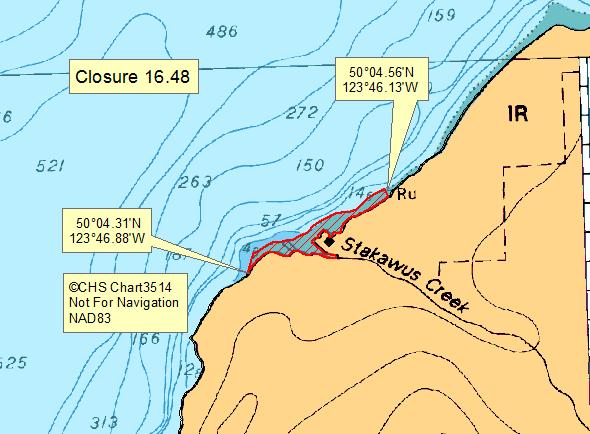
| 16.48 Mouth of Stakawus Creek, Deserted Bay, Jervis Inlet | 16.48.png | The waters and intertidal foreshore of that portion of Subarea 16-14 inside a line that commences 50°4.586'N, 123°46.165'W [mouth of Stakawus Creek, Deserted Bay, Jervis Inlet], then southerly to 50°4.564'N, 123°46.147'W [Deserted Bay, Jervis Inlet], then following the shoreline southwesterly to 50°4.325'N, 123°46.899'W [Deserted Bay, Jervis Inlet], then northeasterly to 50°4.379'N, 123°46.873'W [Deserted Bay, Jervis Inlet], then northeasterly to the point of commencement. [NAD83] |
| 16.49 Hidden Basin, Nelson Island | 16.49.png | The waters and intertidal foreshore at the head of Hidden Basin, Nelson Island, lying north of a line drawn across the entrance to the small cove from a point on land at 49°42.74' north latitude and 124°10.27' west longitude, thence due east to a point on land on the opposite shore at 49°42.74' north latitude and 124°10.15' west longitude. [NAD83] |
| 16.5 Churchill Bay, Francis Peninsula | 16.5.png | The intertidal foreshore of Churchill Bay, Francis Peninsula, lying within a 200 m radius of the northernmost point of the bay. [NAD83] |
| 16.51 Southeast Baker Bay, Hotham Sound | 16.51.png | The waters and intertidal foreshore of southeast Baker Bay, Hotham Sound, within a 160 m radius centered at the westernmost point of land on the small islet at 49°55.02' north latitude and 124°01.98' west longitude. [NAD83] |
| 16.6 Porpoise Bay, Sechelt Inlet | 16.6.png | The waters and intertidal foreshore of Porpoise Bay, Sechelt Inlet, extending from a point on shore at the southern boundary of Porpoise Bay Provincial Park at 49°30.25' north latitude and 123°45.00' west longitude thence southerly along the foreshore to the dock at 49°29.40' north latitude and 123°44.95' west longitude thence westerly to the headland on the opposite shore at 49°29.45' north latitude and 123°45.75' west longitude thence northerly along the foreshore to a point on shore at 49°29.75' north latitude and 123°46.05' west longitude. [NAD83] |
| 16.7 Vancouver Bay, Jervis Inlet | 16.7.png | The intertidal foreshore of Vancouver Bay, Jervis Inlet, inside a line drawn from the southernmost point of land on the north side of the Vancouver River at 49°55.32' north latitude and 123°52.20' west longitude, thence southwest to the mouth of the north arm of the Vancouver River at 49°55.27' north latitude and 123°52.37' west longitude, thence south along the low water mark to the dock at 49°54.85' north latitude and 123°52.15' west longitude. [NAD83] |
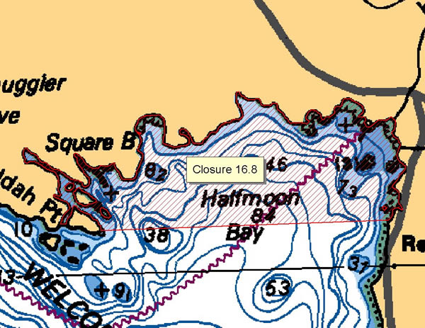
| 16.8 Halfmoon Bay, Sechelt Inlet | 16.8.png | The waters and intertidal foreshore of Halfmoon Bay lying inside a line drawn from the eastern tip of the unnamed island immediately east of Jeddah Point to the unnamed point in line with the south end of the Redroofs bridge. [NAD83] |
| 16.9 Long Bay, Lasqueti Island | 16.9.png | The waters and intertidal foreshore of the unnamed bay, locally known as Long Bay, immediately east of Potter Point, Tucker Bay, Lasqueti Island. [NAD83] |
| 16.A Smuggler Cove | 16.A.png | The waters and intertidal foreshore of that portion of Subarea 16-1 inside a line that commences at 49°30.931'N, 123°58.067'W [unnamed islet], then following the shoreline easterly to 49°30.960'N, 123°58.007'W [unnamed islet], then northeasterly to 49°30.964'N, 123°57.997'W [Capri, Isle], then following the shoreline northeasterly to 49°30.991'N, 123°57.921'W [Capri, Isle], then southeasterly to 49°90.977'N, 123°57.896'W [Smuggler Cove], then following the shoreline southeasterly to 49°30.882'N, 123°58.077'W [Smuggler Cove], then northerly to the point of commencement. [NAD83] |
| 16.C Buccaneer Bay, Thormanby Islands | 16.C.png | The waters and intertidal foreshore of that portion of Subarea 16-1 inside a line that commences at 49°30.569'N, 124°00.092'W [North Thormanby Island], then northeasterly to 49°31.121'N, 123°59.096'W [in water], then southerly to 49°30.480'N, 123°58.962'W [South Thormanby Island], then following the shoreline southerly to 49°29.584'N, 123°59.340'W [South Thormanby Island], then northwesterly to 49°29.682'N, 123°59.450'W [Grassy Point, North Thormanby Island], then following the shoreline northerly to the point of commencement. [NAD83] |
Last updated: 2026-07-13
Related links
- Area maps
- Realtime bivalve shellfish safety harvesting map
- Information about recreational shellfish harvesting in BC
- Shellfish harvesting safety information
- Planned bivalve shellfish harvesting closures
- Identify your catch
Contact us
Email: DFO.PACCSSP-PCAMPAC.MPO@dfo-mpo.gc.ca
- Date modified: