
BC tidal area 18 - Saanich, Saltspring Island, Mayne Island, Pender Island and Saturna Island: Bivalve shellfish contamination information
Eating contaminated shellfish can make you very sick and can even be life threatening.
Harvesting opportunities and closures change often throughout the year for conservation or public health reasons. Check the table below or our real-time bivalve shellfish safety harvesting map to ensure that it's legal and safe to harvest, every time you head out to fish. If you are a recreational harvester, you also need to review recreational shellfish harvesting opportunities and limits and ensure you are carrying a current tidal waters sport fishing licence.
Because of the risk of sanitary contamination, all bivalve shellfish harvesting is permanently closed within the following boundaries, often marked with signage or red concrete markers:
- 300 metres around industrial, municipal and sewage treatment plant outfall discharges
- 125 metres around a marina, ferry wharf, floating living accommodation, or any finfish net pen
If you are in an aquaculture facility there are some exceptions to the second item.
- 25 metres around any floating living accommodation facility located within a shellfish aquaculture facility where a zero-discharge and appropriate waste management plan is a condition of the Aquaculture Licence and is approved by the Regional Interdepartmental Committee
- 0 metres of any finfish net pen within an aquaculture facility where an Integrated Multi-Trophic Aquaculture Management Plan approved by the Regional Interdepartmental Committee is in operation.
Shellfish aquaculture facilities use markers at the corners of their licensed area.
Bivalve shellfish contamination status
Look at the first column below to see which species are safe to harvest. If there is information in the second column, it is both illegal and unsafe to harvest any bivalve species in those areas.
| Subarea | Marine biotoxin update (open bivalve species) | Sanitary contamination closures (closed to shellfish harvesting) |
|---|---|---|
| 18-1 | Closed to All Bivalve Species | |
| 18-2 | Closed to All Bivalve Species | |
| 18-3 | Clam - Butter;Cockles;Clam - Littleneck;Clam - Manila;Mussels - all species combined;Oyster - Pacific |
|
| 18-4 | Closed to All Bivalve Species | |
| 18-5 | Clam - Butter;Clam - Littleneck;Clam - Manila;Clam - Varnish;Mussels - all species combined;Oyster - Pacific |
|
| 18-6 | Closed to All Bivalve Species | |
| 18-7 | Closed to All Bivalve Species | |
| 18-8 | Closed to All Bivalve Species | |
| 18-9 | Closed to All Bivalve Species | |
| 18-10 | Closed to All Bivalve Species | |
| 18-11 | Clam - Butter;Cockles;Clam - Littleneck;Clam - Manila;Mussels - all species combined;Oyster - Pacific |
Last updated: 2026-07-17
Area descriptions
| Closure | Map | Area description |
|---|---|---|
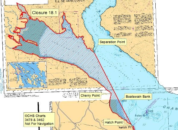
| 18.1 Cowichan Bay, Genoa Bay, Boatswain Bank | 18.1.png | The waters and intertidal foreshore of Cowichan Bay, including Genoa Bay and Boatswain Bank, lying inside a line drawn from Separation Point to Hatch Point. [NAD83] |
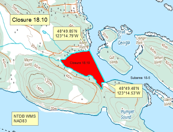
| 18.10 Horton Bay, Mayne Island | 18.10.png | "The waters and intertidal foreshore of Horton Bay, Mayne Island, inside a line drawn from Aitken Point at 48°49.85' north latitude and 123°14.79' west longitude, thence southeasterly to a point on land at 48°49.48' north latitude and 123°14.53' west longitude located east of the public dock. [NAD83] |
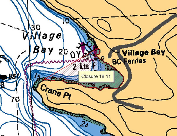
| 18.11 Village Bay, Mayne Island | 18.11.png | The intertidal foreshore of Village Bay, Mayne Island, lying inside a line drawn from a point on land 125 m north of the ferry dock to Crane Point. [NAD83] |
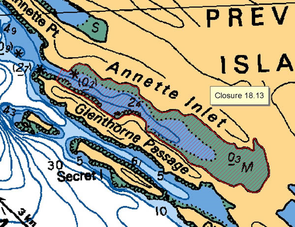
| 18.13 Annette Inlet, Prevost Island | 18.13.png | The waters and intertidal foreshore of Annette Inlet, Prevost Island, lying inside a line drawn across the narrowest point at the west end of the inlet. [NAD83] |
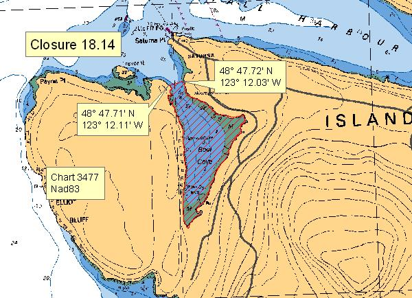
| 18.14 Boot Cove, Saturna Island | 18.14.png | The waters and intertidal foreshore of Boot Cove, lying inside of a line from a point on land at 48°47.71' north latitude and 123°12.11' west longitude, thence northeasterly to a point on land at 48°47.72' north latitude and 123°12.03' west longitude. [NAD83] |
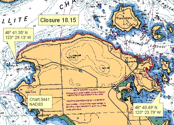
| 18.15 Northeast Saanich Peninsula | 18.15.png | The intertidal foreshore of Saanich Peninsula, lying between Curteis Point at 48°40.49' north latitude and 123°23.79' west longitude and Moses Point at 48°41.35' north latitude and 123°29.13' west longitude, which lies at the eastern boundary of the beach access road at the foot of Seabreeze Road. [NAD 83] |
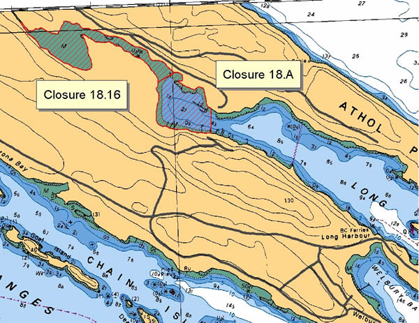
| 18.16 Long Harbour, Saltspring Island | 18.16.png | The waters and intertidal foreshore at the head of Long Harbour, Saltspring Island, lying inside a line drawn from the north side at 48°51.82' north latitude and 123°27.91' west longitude to the opposite shore at 48°51.77' north latitude and 123°28.00' west longitude. [NAD 83]. |
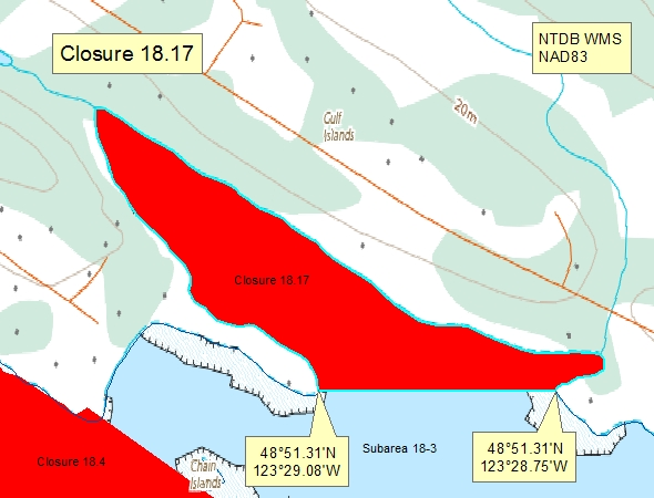
| 18.17 - Madrona Bay, Saltspring Island | 18.17.png | The waters and intertidal foreshore of Madrona Bay, Saltspring Island, lying north of a line drawn from a point of land at 48°51.31' north latitude and 123°29.08' west longitude due east to a point of land at 48°51.31' north latitude and 123°28.75' west longitude. [NAD83] |
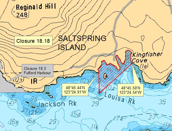
| 18.18 Unnamed bays E of Fulford Harbour, Saltspring Is. | 18.18.png | The waters and intertidal foreshore of the three unnamed bays east of Fulford Harbour, Saltspring Island, lying inside a line drawn from the western headland at 48°45.45' north latitude and 123°24.85' west longitude thence due south to Louisa Rock, thence on a true bearing of 50° to the northeasterly headland at 48°45.50' north latitude and 123°24.45' west longitude. [NAD 83]. |
| 18.20 Selby Cove, Prevost Island | 18.20.png | The waters and intertidal foreshore of Selby Cove, Prevost Island, lying inside a line drawn across the entrance to the cove. [NAD83] |
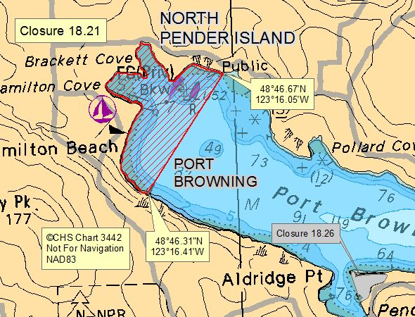
| 18.21 Port Browning, North Pender Island | 18.21.png | The waters and intertidal foreshore at the head of Port Browning, North Pender Island, inside a line drawn from the public wharf on the northern shore of Port Browning at 48°46.70' north latitude and 123°15.95' west longitude, thence southwesterly to the edge of the rocky shoal at 48°46.30' north latitude and 123°16.35' west longitude. [NAD 27]. |
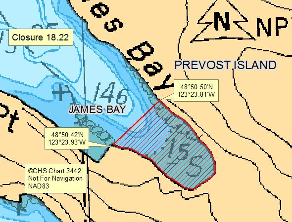
| 18.22 James Bay, Prevost Island | 18.22.png | The waters and intertidal foreshore of James Bay, Prevost Island, from a point of land on the south shore at 48°50.43' north latitude and 123°23.85' west longitude, thence northeasterly to the north shore at 48°50.50' north latitude and 123°23.72' west longitude. [NAD 83]. |
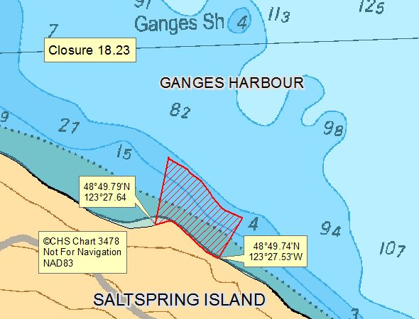
| 18.23 1.4 km From Walker Spit, Ganges Hbr. Saltspring Is | 18.23.png | The waters and intertidal foreshore on the southern shore of Ganges Harbour, Saltspring Island, from an abandoned wharf at 48°49.78' north latitude and 123°27.65' west longitude, thence approximately 150 meters eastward to 48°49.75' north latitude and 123°27.53' west longitude. [NAD83] |
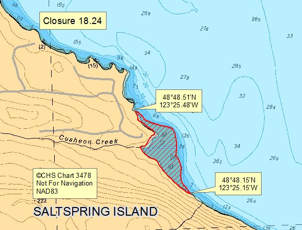
| 18.24 Cusheon Creek, Saltspring island | 18.24.png | The intertidal foreshore of Cusheon Creek , lying between a point on land northwesterly of Cusheon Creek at 48°48.51' north latitude and 123°25.44' west longitude, and a point on land southeasterly of Cusheon Creek at 48°48.17' north latitude and 123°25.15' west longitude. [NAD83] |
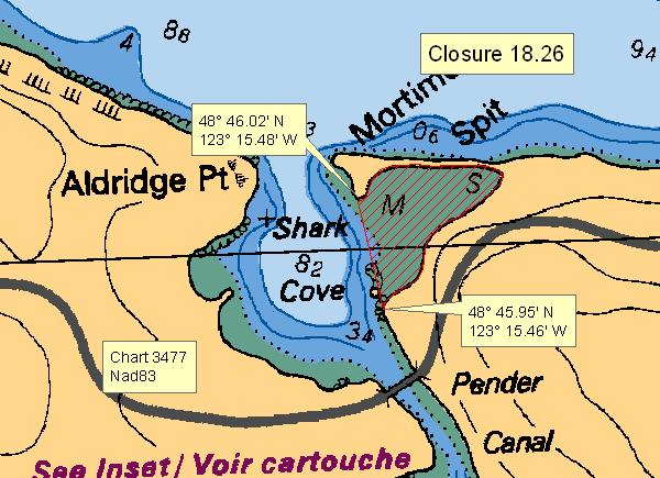
| 18.26 Shark Cove | 18.26.png | The waters and intertidal foreshore of Shark Cove, inside of a line from a southerly point on land at 48°45.95' north latitude and 123°15.46' west longitude, thence northerly to a point on land near the end of Mortimer Spit at 48°46.02' north latitude and 123°15.48' west longitude. [NAD83] |
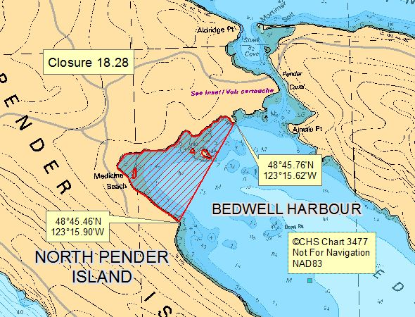
| 18.28 Bedwell Harbour, North Pender Island | 18.28.png | The waters and intertidal foreshore at the head of Bedwell Bay, North Pender Island, lying inside of a line from a point of land at 48°45.76' north latitude and 123°15.62' west longitude thence southerly to a point of land at 48°45.46' north latitude and 123°15.90' west longitude. [NAD83] |
| 18.29 Dinner Bay, Mayne Island | 18.29.png | The waters and intertidal foreshore of Dinner Bay lying east of a line drawn from a point of land on Mayne Island at 48°50.23' north latitude and 123°19.42' west longitude, thence southwest to a point on land on Mayne Island at 48°50.09' north latitude and 123°19.59' west longitude. [NAD83] |
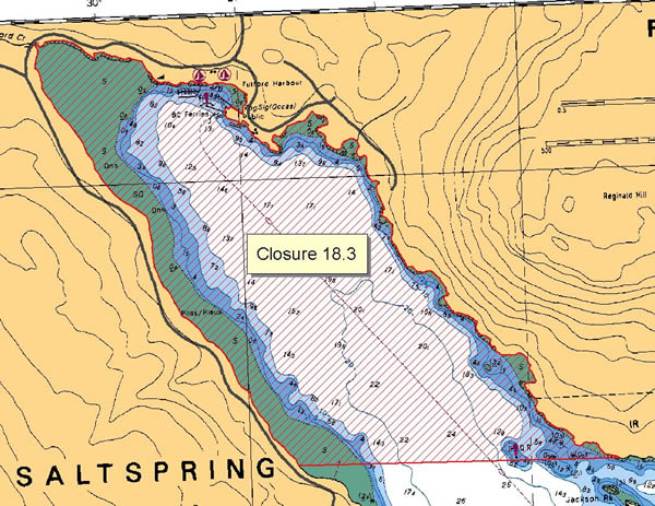
| 18.3 Fulford Harbour, Saltspring Island | 18.3.png | The waters and intertidal foreshore of Fulford Harbour, Saltspring Island, lying inside a line drawn in a due east-west direction through the quick-flashing red light on the southeast side of the harbour. [NAD83] |
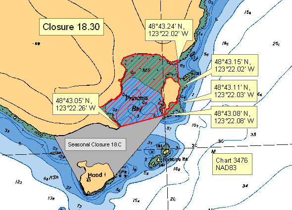
| 18.30 Princess Bay, Portland Island | 18.30.png | The waters and intertidal foreshore of Princess Bay located inside a line drawn from a point of land on Portland Island at 48°43.05 north latitude and 123°22.26' west longitude, thence northeast to the southernmost point of the unnamed island located north of the Tortoise Islets at 48°43.08' north latitude and 123°22.08' west longitude, thence northeast to a point of land at 48°43.11' north latitude and 123°22.03' west longitude, thence following the shoreline to the easternmost point of the unnamed island at 48°43.15' north latitude and 123°22.02' west longitude, thence due north to the shore of Portland Island at 48°43.24' north latitude and 123°22.02' west longitude. [NAD83] |
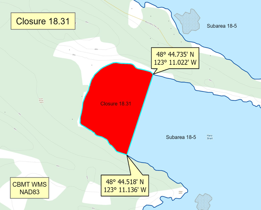
| 18.31 Camp Bay, South Pender Island | 18.31.png | The waters and intertidal foreshore of that portion of Subarea 18-5 inside a line that commences at 48°44.735'N, 123°11.022'W [Camp Bay, South Pender Island], then southwesterly to 48°44.518'N, 123°11.136'W [Camp Bay, South Pender Island], then following the shoreline northerly to the point of commencement. [NAD83] |
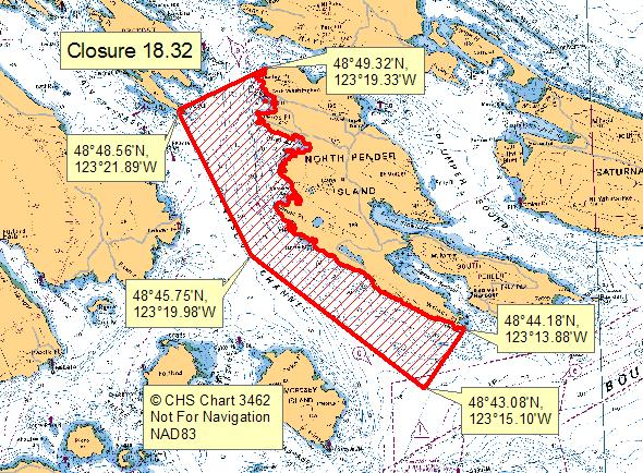
| 18.32 Stanley Point to Wallace Point, North Pender Island | 18.32.png | The waters and intertidal foreshore along the west side of North Pender Island inside a line drawn from a point on land at Stanley Point at 48°49.32' north latitude and 123°19.33' west longitude to Point Liddell, Prevost Island, at 48°48.56' north latitude and 123°21.89' west longitude, thence southeasterly to a point in water at 48°45.75' north latitude and 123°19.98' west longitude, thence southeasterly to a point in water at 48°43.08' north latitude and 123°15.10' west longitude, then northeasterly to Wallace Point at 48°44.18' north latitude and 123°13.88' west longitude, thence northwesterly following the shoreline of North Pender Island to the point of commencement. [NAD83] |
| 18.33 Burgoyne Bay, Saltspring Island | 18.33.png | The waters and intertidal foreshore of Burgoyne Bay lying inside a line drawn from a point on land at 48°47.66' north latitude and 123°31.31' west longitude southeasterly following the high water mark to a point on land at 48°47.46' north latitude and 123°31.08' west longitude, thence southwesterly to a point on land at 48°47.27' north latitude and 123°31.20' west longitude, thence northwesterly following the high water mark to a point on land at 48°47.37' north latitude and 123°31.63' west longitude, and thence northeasterly in a straight line to the point of commencement. [NAD 83] |
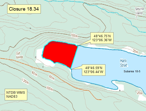
| 18.34 A portion of Narvaez Bay | 18.34.png | A portion of Narvaez Bay - The waters and intertidal foreshore of the head of Narvaez Bay lying west of a line drawn from a point on land at 48°46.75' north latitude and 123°06.36' west longitude thence southwesterly to a point on land at 48°46.59' north latitude and 123°06.44' west longitude. [NAD83] |
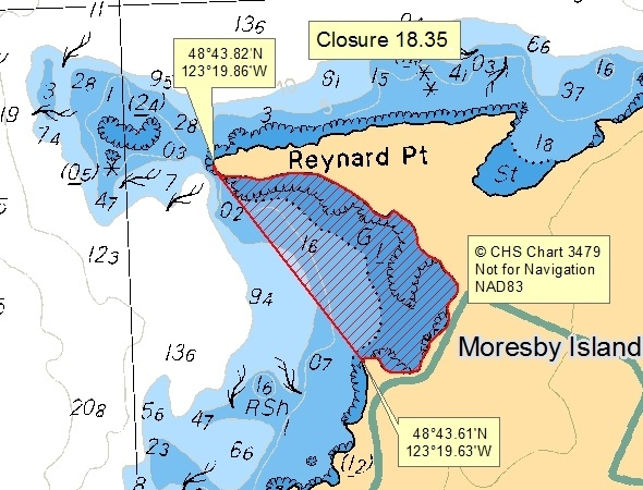
| 18.35 Head of the Bay, south of Reynard Point on northwest Moresby Island | 18.35.png | The waters and intertidal foreshore of the head of the bay south of Reynard Point on northwest Moresby Island lying east of a line drawn from a point of land at 48º43.82' north latitude and 123º19.86' west longitude thence southeasterly to a point of land at 48°43.61' north latitude and 123°19.63' west longitude. [NAD83] |
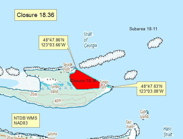
| 18.36 - East side of Tumbo Island | 18.36.png | The waters and intertidal foreshore of the unnamed bay on the east side of Tumbo Island, lying west of a line drawn from Savage Point at 48°47.86' north latitude and 123°03.66' west longitude thence southeasterly to Tumbo Point at 48°47.63' north latitude and 123°03.08' west longitude. [NAD83] |
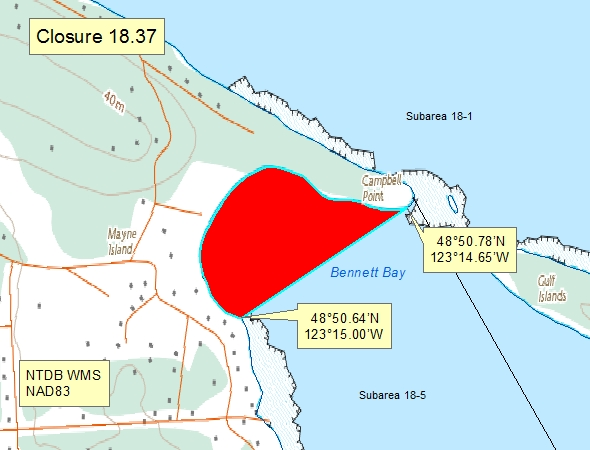
| 18.37 Bennett Bay, Mayne Island | 18.37.png | The waters and intertidal foreshore of Bennett Bay, Mayne Island, inside a line drawn from a point on land at 48°50.64', north latitude and 123°15.00' west longitude, thence northeasterly to a point of land at 48°50.78' north latitude and 123°14.65' west longitude. [NAD83] |
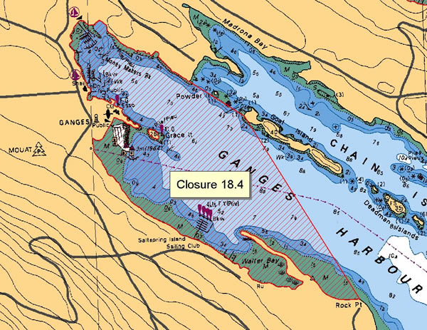
| 18.4 Ganges Harbour, Saltspring Island | 18.4.png | The waters and intertidal foreshore of Ganges Harbour, Saltspring Island, including Walter Bay lying inside a line drawn from the shore of Saltspring Island at 48°51.30 north latitude and 123°29.31' west longitude thence easterly to the west end of Goat Island at 48°51.17' north latitude and 123°29.00' west longitude and thence southerly to Rock Point at 48°50.40' north latitude and 123°28.40' west longitude. [NAD83] |
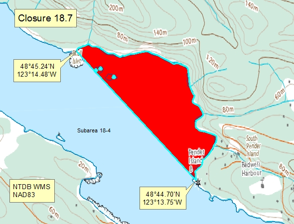
| 18.7 Bedwell Harbour, South Pender Island | 18.7.png | The waters and intertidal foreshore of Bedwell Harbour, lying inside of a line drawn across the harbour from a point on land on the south-western shore of South Pender Island located at 48°45.24' north latitude and 123°14.48' west longitude thence south-easterly to a point on land at 48°44.70' north latitude 123°13.75' west longitude. [NAD83] |
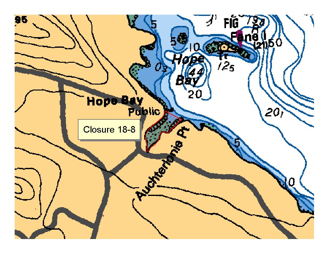
| 18.8 Hope Bay, North Pender Island | 18.8.png | The waters and intertidal foreshore of Hope Bay, north Pender Island, lying inside, that is south of, a line drawn from the land end of the government dock to Auchterlonie Point on the opposite side. [NAD83] |
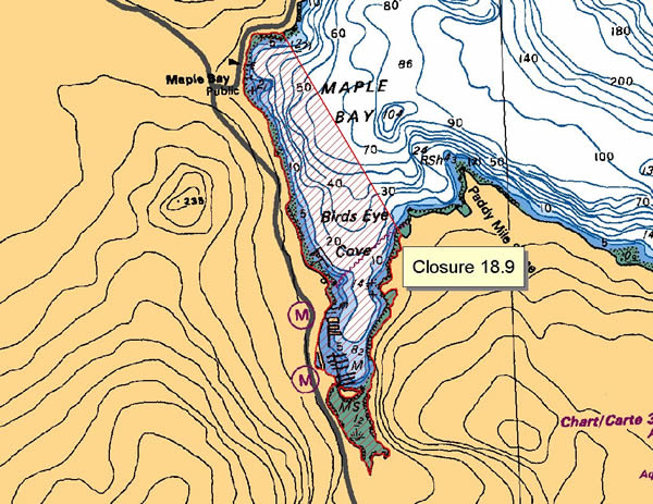
| 18.9 Maple Bay | 18.9.png | The waters and intertidal foreshore of Maple Bay, lying inside a line drawn from a point on the west shore located at 48°49.06 north latitude and 123°36.30' west longitude, thence southeasterly to the eastern shore at 48°48.25' north latitude and 123°35.72' west longitude [NAD 83 ]. |
| 18.A Long Harbour, Saltspring Island | 18.A.png | The waters and intertidal foreshore of that portion of Subarea 18-3 inside a line that commences at 48°51.394'N, 123°27.317'W [Long Harbour, Saltspring Island], then northeasterly to 48°51.810'N, 123°27.985'W [Long Harbour, Saltspring Island], then following the shoreline southeasterly to 48°51.625'N, 123°27.724'W [Long Harbour, Saltspring Island], then southerly to 48°51.546'N, 123°27.731'W [Long Harbour, Saltspring Island], then following the shoreline westerly to the point of commencement. [NAD83] |
| 18.B Reef Harbour, Tumbo Island | 18.B.png | The waters and intertidal foreshore of that portion of Subarea 18-11 inside a line that commences at 48°47.937'N, 123°05.340'W [Cabbage Island], then following the shoreline southeasterly to 48°47.938'N, 123°05.133'W [Cabbage Island], then easterly to 48°47.870'N, 123°04.546'W [Tumbo Island], then following the shoreline southerly to 48°47.756'N, 123°05.344'W [Tumbo Island], then northerly to the point of commencement. [NAD83] |
| 18.C Princess Bay, Portland Island | 18.C.png | The waters and intertidal foreshore of that portion of Subarea 18-6 inside a line that commences at 48°43.041'N, 123°22.525'W [Portland Island], then following the shoreline easterly to 48°43.054'N, 123°22.269'W [Portland Island], then easterly to 48°43.069'N, 123°22.083'W [Tortoise Islets], then southwesterly to 48°42.927'N, 123°22.294'W [Hood Island], then northerly to 48°42.920'N, 123°22.432'W [Hood Island], then northwesterly to the point of commencement. [NAD83] |
| 18.D Winter Cove | 18.D.png | The waters and intertidal foreshore of that portion of Subarea 18-5 inside the line that commences at 48°48.840'N, 123°12.213'W [Samuel Island], then following the shoreline easterly to 48°48.861'N, 123°11.353'W [Ralph Grey Point, Samuel Island], then southeasterly to 48°48.834'N, 123°11.338'W [Winter Point, Saturna Island], then following the shoreline southerly to 48°48.658'N, 123°12.208'W [Mikuni Point, Saturna Island], then northerly to the point of commencement. [NAD83] |
| 18.ii A Portion of Sansum Narrows, North Cowichan | The waters and intertidal foreshore of that portion of Subarea 18-7 inside a line that commences at 48°48.521'N, 123°35.333'W [Paddy Mile Stone, Vancouver Island], then northeasterly to 48°48.759'N, 123°33.222'W [Saltspring Island], then southwesterly to 48°47.945'N, 123°33.761'W [Octopus Point, Vancouver Island], then following the shoreline northerly to the point of commencement. [NAD83] |
Last updated: 2026-07-17
Related links
- Area maps
- Realtime bivalve shellfish safety harvesting map
- Information about recreational shellfish harvesting in BC
- Shellfish harvesting safety information
- Planned bivalve shellfish harvesting closures
- Identify your catch
Contact us
Email: DFO.PACCSSP-PCAMPAC.MPO@dfo-mpo.gc.ca
- Date modified: