
BC tidal areas 26 and 126 - Kyuquot Sound: Bivalve shellfish contamination information
Eating contaminated shellfish can make you very sick and can even be life threatening.
Harvesting opportunities and closures change often throughout the year for conservation or public health reasons. Check the table below or our real-time bivalve shellfish safety harvesting map to ensure that it's legal and safe to harvest, every time you head out to fish. If you are a recreational harvester, you also need to review recreational shellfish harvesting opportunities and limits and ensure you are carrying a current tidal waters sport fishing licence.
Because of the risk of sanitary contamination, all bivalve shellfish harvesting is permanently closed within the following boundaries, often marked with signage or red concrete markers:
- 300 metres around industrial, municipal and sewage treatment plant outfall discharges
- 125 metres around a marina, ferry wharf, floating living accommodation, or any finfish net pen
If you are in an aquaculture facility there are some exceptions to the second item.
- 25 metres around any floating living accommodation facility located within a shellfish aquaculture facility where a zero-discharge and appropriate waste management plan is a condition of the Aquaculture Licence and is approved by the Regional Interdepartmental Committee
- 0 metres of any finfish net pen within an aquaculture facility where an Integrated Multi-Trophic Aquaculture Management Plan approved by the Regional Interdepartmental Committee is in operation.
Shellfish aquaculture facilities use markers at the corners of their licensed area.
Bivalve shellfish contamination status
Look at the first column below to see which species are safe to harvest. If there is information in the second column, it is both illegal and unsafe to harvest any bivalve species in those areas.
| Subarea | Marine biotoxin update (open bivalve species) | Sanitary contamination closures (closed to shellfish harvesting) |
|---|---|---|
| 26-1 | Closed to All Bivalve Species | |
| 26-2 | Closed to All Bivalve Species | |
| 26-3 | Clam - Littleneck;Clam - Manila;Mussels - all species combined;Oyster - Pacific | |
| 26-4 | Closed to All Bivalve Species | |
| 26-5 | Closed to All Bivalve Species | |
| 26-6 | Closed to All Bivalve Species | |
| 26-7 | Closed to All Bivalve Species | |
| 26-8 | Closed to All Bivalve Species | |
| 26-9 | Closed to All Bivalve Species | |
| 26-10 | Closed to All Bivalve Species | |
| 26-11 | Closed to All Bivalve Species | |
| 126-1 | Closed to All Bivalve Species | |
| 126-2 | Closed to All Bivalve Species | |
| 126-3 | Closed to All Bivalve Species | |
| 126-4 | Closed to All Bivalve Species |
Last updated: 2026-06-26
Area descriptions
| Closure | Map | Area description |
|---|---|---|
| 26.1 Yaku Bay, Tahsish Inlet, Kyuquot Sound | 26.1.png | The waters and intertidal foreshore of Yaku Bay westerly of a line from a point on land at 50°06.23' north latitude and 127°09.12' west longitude to a point of land at the western entrance of the unnamed bay at 50°06.38' north latitude and 127°08.87' west longitude. [NAD 83] |
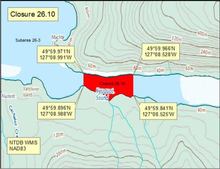
| 26.10 Cachalot Inlet, Kyuquot Sound | 26.10.png | The waters and intertidal foreshore of Cachalot Inlet, inside a line drawn from the point of land at 49°59.896' north latitude and 127°08.988' west longitude northerly to a point on land at 49°59.971' north latitude and 127°08.991' west longitude, thence following the high tide mark easterly to a point on land at 49°59.966' north latitude and 127°08.528' west longitude, thence southerly to a point of land on the opposite shore at 49°59.841' north latitude and 127°08.525' west longitude, thence following the high tide mark westerly to the point of commencement. [NAD83] |
| 26.18 Chamiss Creek | 26.18.png | The waters and intertidal foreshore at the mouth of Chamiss Creek, inside a line drawn from a point on land at 50°04.41' north latitude and 127°17.16' west longitude, thence north easterly to a point on land at 50°04.58' north latitude and 127°16.74' west longitude. [NAD83] |
| 26.20 Ououkinsh Inlet | 26.20.png | The waters and intertidal foreshore of the easternmost end of the head of Ououkinsh Inlet, east of a line drawn from a point of land at 50°10.84' north latitude and 127°26.69' west longitude, thence northerly to a point of land at 50°11.20' north latitude and 127°26.62' west longitude. [NAD83] |
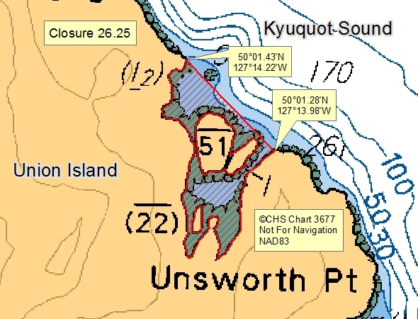
| 26.25 Union Island, Kyuquot Sound | 26.25.png | The waters and intertidal foreshore of the unnamed bay north of Unsworth Point, on eastern Union Island, Kyuquot Sound, southerly of a line drawn from a point on land at 50°01.28' north latitude and 127°13.98' west longitude, thence northwest to a point of land at 50°01.43' north latitude and 127°14.22' west longitude. [NAD 83] |
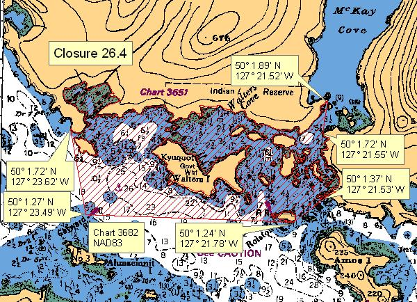
| 26.4 Walters cove, Kyuquot Sound | 26.4.png | The waters and intertidal foreshore of Walters Cove, Kyuquot Sound, lying inside a line drawn from the western headland of Walters Cove at 50°01.72' north latitude and 127°23.62' west longitude to the Gayward Rock light at 50°01.27' north latitude and 127°23.49' west longitude, thence to the southeastern tip of Rolston Island at 50°01.24' north latitude and 127°21.78' west longitude, thence northeast to a point of land at 50°01.37' north latitude and 127°21.53' west longitude, thence following the shoreline northwards to a point of land at 50°01.72' north latitude and 127°21.55' west longitude, thence north to a point of land at 50°01.89' north latitude and 127°21.52' west longitude, thence following the shoreline to the point of commencement. [NAD 83]. |
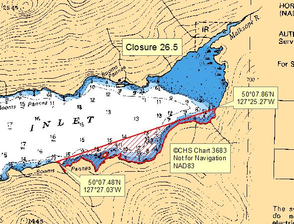
| 26.5 Head of Malksope Inlet | 26.5.png | The waters and intertidal foreshore of the eastern end of Malksope Inlet, southeast of a line drawn from a point on land at 50°07.86' north latitude and 127°25.27' west longitude, thence southwesterly to a point of land at 50°07.48' north latitude and 127°27.03' west longitude. [NAD 83] |
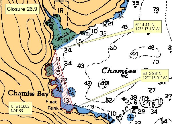
| 26.9 Chamiss Bay, Kashutl Inlet | 26.9.png | The waters and intertidal foreshore of Chamiss Bay westerly of a line from a point of land at 50°04.41' north latitude and 127°17.16' west longitude thence southeasterly to a headland at 50°03.96' north latitude and 127°16.91' west longitude. [NAD 83] |
Last updated: 2026-06-26
Related links
- Area maps
- Realtime bivalve shellfish safety harvesting map
- Information about recreational shellfish harvesting in BC
- Shellfish harvesting safety information
- Planned bivalve shellfish harvesting closures
- Identify your catch
Contact us
Email: DFO.PACCSSP-PCAMPAC.MPO@dfo-mpo.gc.ca
- Date modified: