
BC tidal area 28 - Vancouver, Bowen Island, Indian Arm, Squamish: Bivalve shellfish contamination information
Eating contaminated shellfish can make you very sick and can even be life threatening.
Harvesting opportunities and closures change often throughout the year for conservation or public health reasons. Check the table below or our real-time bivalve shellfish safety harvesting map to ensure that it's legal and safe to harvest, every time you head out to fish. If you are a recreational harvester, you also need to review recreational shellfish harvesting opportunities and limits and ensure you are carrying a current tidal waters sport fishing licence.
Because of the risk of sanitary contamination, all bivalve shellfish harvesting is permanently closed within the following boundaries, often marked with signage or red concrete markers:
- 300 metres around industrial, municipal and sewage treatment plant outfall discharges
- 125 metres around a marina, ferry wharf, floating living accommodation, or any finfish net pen
If you are in an aquaculture facility there are some exceptions to the second item.
- 25 metres around any floating living accommodation facility located within a shellfish aquaculture facility where a zero-discharge and appropriate waste management plan is a condition of the Aquaculture Licence and is approved by the Regional Interdepartmental Committee
- 0 metres of any finfish net pen within an aquaculture facility where an Integrated Multi-Trophic Aquaculture Management Plan approved by the Regional Interdepartmental Committee is in operation.
Shellfish aquaculture facilities use markers at the corners of their licensed area.
Bivalve shellfish contamination status
Look at the first column below to see which species are safe to harvest. If there is information in the second column, it is both illegal and unsafe to harvest any bivalve species in those areas.
| Subarea | Marine biotoxin update (open bivalve species) | Sanitary contamination closures (closed to shellfish harvesting) |
|---|---|---|
| 28-1 | Closed to All Bivalve Species | |
| 28-2 | Closed to All Bivalve Species | |
| 28-3 | Closed to All Bivalve Species | |
| 28-4 | Closed to All Bivalve Species | |
| 28-5 | Closed to All Bivalve Species | |
| 28-6 | Closed to All Bivalve Species | |
| 28-7 | Closed to All Bivalve Species | |
| 28-8 | Closed to All Bivalve Species | |
| 28-9 | Closed to All Bivalve Species | |
| 28-10 | Closed to All Bivalve Species | |
| 28-11 | Closed to All Bivalve Species | |
| 28-12 | Closed to All Bivalve Species | |
| 28-13 | Closed to All Bivalve Species | |
| 28-14 | Closed to All Bivalve Species |
Last updated: 2026-06-09
Area descriptions
| Closure | Map | Area description |
|---|---|---|
| 28.1 Burrard Inlet, Indian Arm and Vancouver Harbour | 28.1.png | The waters and intertidal foreshore of Burrard Inlet, Indian Arm and Vancouver Harbour lying inside, that is easterly and northerly, of a line drawn from the western end of the Fraser River North Arm Jetty to Point Atkinson. [NAD83] |
| 28.10 Squamish Harbour | 28.10.png | The waters and intertidal foreshore of Squamish harbour north of a line drawn from a point of land on the western shore at 49°40.90' north latitude and 123°11.41' west longitude, thence easterly to a point of land on the eastern shore at 49°40.68' north latitude and 123°09.50' west longitude. [NAD83] |
| 28.12 Howe Sound South | 28.12.png | The waters and intertidal foreshore of Subarea 28-1 in Howe Sound lying inside a line that commences at a point of land on Keats Island at 49°24.360' north latitude and 123°28.295' west longitude, thence southwesterly to a point on land on northern Shelter Islet at 49°24.221' north latitude and 123°28.669' west longitude, thence following the high tide mark southerly to a point on land at 49°24.175' north latitude and 123°28.697' west longitude, thence southeasterly to a point on land on southern Shelter Islet at 49°24.136' north latitude and 123°28.680' west longitude, thence following the high tide mark southerly to a point on land at 49°24.043' north latitude and 123°28.693' west longitude, thence southwesterly to a point of land on Keats Island at 49°23.906' north latitude and 123°28.713' west longitude, thence following the high tide mark easterly to the point of commencement. [NAD83] |
| 28.2 Horseshoe Bay | 28.2.png | That portion of Horseshoe Bay, lying inside a line drawn due east from the northern tip of Tyee Point to the opposite shore of Horseshoe Bay. [NAD83] |
| 28.3 Gower Point to Soames Point, Gibsons Landing | 28.3.png | The intertidal foreshore from Gower Point to Soames Point, Gibsons Landing. [NAD83] |
| 28.4 Port Graves, Gambier Island | 28.4.png | The intertidal foreshore at the head of Port Graves, Gambier Island. [NAD83] |
| 28.5 Camp Fircom, Halkett Bay, Gambier Island | 28.5.png | The intertidal foreshore lying within a 200 m radius of the Camp Fircom sewage outfall, Halkett Bay, Gambier Island. [NAD83] |
| 28.6 McNab Creek | 28.6.png | That portion of the intertidal foreshore known as McNab Creek. [NAD83] |
| 28.7 Potlatch Creek | 28.7.png | The intertidal foreshore lying 200 m to the west and 400 m to the east of the mouth of Potlatch Creek. [NAD83] |
| 28.8 Mannion Bay (Deep Bay) Bowen Island | 28.8.png | The intertidal foreshore of Deep Bay, Bowen Island, lying inside a line drawn from the red navigation beacon on the south shore of Deep Bay to the foot of Ocean View Road. [NAD83] |
| 28.9 Grafton Bay, Bowen Island | 28.9.png | The intertidal foreshore at the mouth of Grafton Creek, Grafton Bay, Bowen Island. [NAD83] |
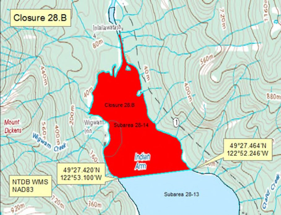
| 28.B Indian Arm, Burrard Inlet | 28.B.png | The waters and intertidal foreshore of that portion of Subarea 28-14 inside the line that commences at 49°27.420'N, 122°53.100'W [Indian Arm, Burrard Inlet], then following the shoreline northerly to 49°27.464'N, 122°52.246'W [Iron Bay, Indian Arm, Burrard Inlet], then westerly to the point of commencement. [NAD83] |
Last updated: 2026-06-09
Related links
- Area maps
- Realtime bivalve shellfish safety harvesting map
- Information about recreational shellfish harvesting in BC
- Shellfish harvesting safety information
- Planned bivalve shellfish harvesting closures
- Identify your catch
Contact us
Email: DFO.PACCSSP-PCAMPAC.MPO@dfo-mpo.gc.ca
- Date modified: