
BC tidal areas 6 and 106 - Kitimat, Kemano Bay: Bivalve shellfish contamination information
Eating contaminated shellfish can make you very sick and can even be life threatening.
Harvesting opportunities and closures change often throughout the year for conservation or public health reasons. Check the table below or our real-time bivalve shellfish safety harvesting map to ensure that it's legal and safe to harvest, every time you head out to fish. If you are a recreational harvester, you also need to review recreational shellfish harvesting opportunities and limits and ensure you are carrying a current tidal waters sport fishing licence.
Because of the risk of sanitary contamination, all bivalve shellfish harvesting is permanently closed within the following boundaries, often marked with signage or red concrete markers:
- 300 metres around industrial, municipal and sewage treatment plant outfall discharges
- 125 metres around a marina, ferry wharf, floating living accommodation, or any finfish net pen
If you are in an aquaculture facility there are some exceptions to the second item.
- 25 metres around any floating living accommodation facility located within a shellfish aquaculture facility where a zero-discharge and appropriate waste management plan is a condition of the Aquaculture Licence and is approved by the Regional Interdepartmental Committee
- 0 metres of any finfish net pen within an aquaculture facility where an Integrated Multi-Trophic Aquaculture Management Plan approved by the Regional Interdepartmental Committee is in operation.
Shellfish aquaculture facilities use markers at the corners of their licensed area.
Bivalve shellfish contamination status
Look at the first column below to see which species are safe to harvest. If there is information in the second column, it is both illegal and unsafe to harvest any bivalve species in those areas.
| Subarea | Marine biotoxin update (open bivalve species) | Sanitary contamination closures (closed to shellfish harvesting) |
|---|---|---|
| 6-1 | Closed to All Bivalve Species | |
| 6-2 | Closed to All Bivalve Species | |
| 6-3 | Closed to All Bivalve Species | |
| 6-4 | Closed to All Bivalve Species | |
| 6-5 | Closed to All Bivalve Species | |
| 6-6 | Closed to All Bivalve Species | |
| 6-7 | Closed to All Bivalve Species | |
| 6-8 | Closed to All Bivalve Species | |
| 6-9 | ||
| 6-10 | ||
| 6-11 | Closed to All Bivalve Species | |
| 6-12 | Closed to All Bivalve Species | |
| 6-13 | ||
| 6-14 | Closed to All Bivalve Species | |
| 6-15 | Closed to All Bivalve Species | |
| 6-16 | Closed to All Bivalve Species | |
| 6-17 | Closed to All Bivalve Species | |
| 6-18 | Closed to All Bivalve Species | |
| 6-19 | Closed to All Bivalve Species | |
| 6-20 | Closed to All Bivalve Species | |
| 6-21 | Closed to All Bivalve Species | |
| 6-22 | Closed to All Bivalve Species | |
| 6-23 | Closed to All Bivalve Species | |
| 6-24 | Closed to All Bivalve Species | |
| 6-25 | Closed to All Bivalve Species | |
| 6-26 | Closed to All Bivalve Species | |
| 6-27 | Closed to All Bivalve Species | |
| 6-28 | Closed to All Bivalve Species | |
| 106-1 | Closed to All Bivalve Species | |
| 106-2 | Closed to All Bivalve Species |
Last updated: 2026-06-09
Area descriptions
| Closure | Map | Area description |
|---|---|---|
| 6.1 Kitimat Arm | 6.1.png | The waters and tidal foreshore of Kitimat Arm, lying inside a line drawn between Raley Point and a point 400 m north of the mouth of Bish Creek. [NAD83] |
| 6.3 Hartley Bay | 6.3.png | The waters and intertidal foreshore of Hartley Bay, Douglas Channel, lying inside a line drawn from Sutton Pt. at 53°25.35' north latitude and 129°14.98' west longitude, then northeast to the point on land at the opposite side of the bay at 53°25.45' north latitude and 129°14.70' west longitude. [NAD27] |
| 6-10.A | That portion of Subarea 6-10 east of a line from 53°04.716'N and 129°15.000'W to 52°51.805'N and 129°15.000'W. [NAD 83] | |
| 6-10.B | That portion of Subarea 6-10 west of a line from 53°04.716'N and 129°15.000'W to 52°51.805'N and 129°15.000'W. [NAD 83] | |
| 6-13.A | 6-13.A.png | That portion of Subarea 6-13 north of a line (parallel) running along 52 degrees 40.85 minutes north latitude. |
| 6-13.B | 6-13.B.png | That portion of Subarea 6-13 south of a line (parallel) running along 52 degrees 40.85 minutes north latitude. |
| 6-9.A | 6-9.A.png | That portion of Subarea 6-9 north of a line at 53°06.889' N, 129°33.558' W to 53°06.889' N, 129°52.986' W. [NAD 83] |
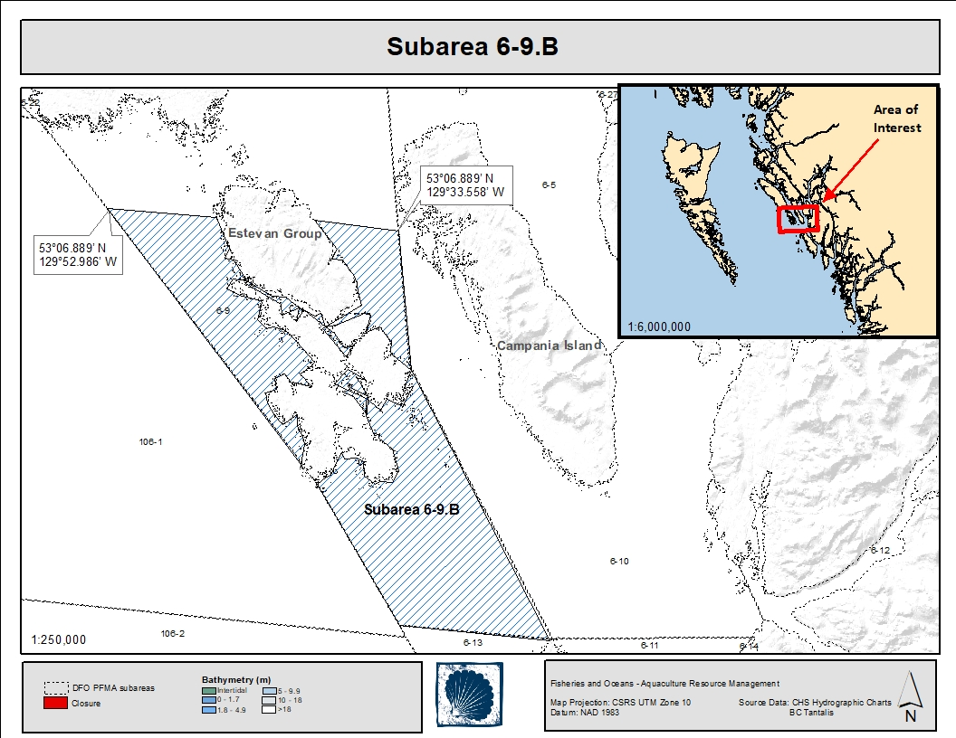
| 6-9.B | 6-9.B.png | That portion of Subarea 6-9 south of a line at 53°06.889' N, 129°33.558' W to 53°06.889' N, 129°52.986' W. [NAD 83] |
Last updated: 2026-06-09
Related links
- Area maps
- Realtime bivalve shellfish safety harvesting map
- Information about recreational shellfish harvesting in BC
- Shellfish harvesting safety information
- Planned bivalve shellfish harvesting closures
- Identify your catch
Contact us
Email: DFO.PACCSSP-PCAMPAC.MPO@dfo-mpo.gc.ca
- Date modified: