
BC tidal areas 7 and 107 - Bella Bella, Denny Island: Bivalve shellfish contamination information
Eating contaminated shellfish can make you very sick and can even be life threatening.
Harvesting opportunities and closures change often throughout the year for conservation or public health reasons. Check the table below or our real-time bivalve shellfish safety harvesting map to ensure that it's legal and safe to harvest, every time you head out to fish. If you are a recreational harvester, you also need to review recreational shellfish harvesting opportunities and limits and ensure you are carrying a current tidal waters sport fishing licence.
Because of the risk of sanitary contamination, all bivalve shellfish harvesting is permanently closed within the following boundaries, often marked with signage or red concrete markers:
- 300 metres around industrial, municipal and sewage treatment plant outfall discharges
- 125 metres around a marina, ferry wharf, floating living accommodation, or any finfish net pen
If you are in an aquaculture facility there are some exceptions to the second item.
- 25 metres around any floating living accommodation facility located within a shellfish aquaculture facility where a zero-discharge and appropriate waste management plan is a condition of the Aquaculture Licence and is approved by the Regional Interdepartmental Committee
- 0 metres of any finfish net pen within an aquaculture facility where an Integrated Multi-Trophic Aquaculture Management Plan approved by the Regional Interdepartmental Committee is in operation.
Shellfish aquaculture facilities use markers at the corners of their licensed area.
Bivalve shellfish contamination status
Look at the first column below to see which species are safe to harvest. If there is information in the second column, it is both illegal and unsafe to harvest any bivalve species in those areas.
| Subarea | Marine biotoxin update (open bivalve species) | Sanitary contamination closures (closed to shellfish harvesting) |
|---|---|---|
| 7-1 | Closed to All Bivalve Species | |
| 7-2 | Closed to All Bivalve Species | |
| 7-3 | ||
| 7-4 | Closed to All Bivalve Species | |
| 7-5 | Closed to All Bivalve Species | |
| 7-6 | Closed to All Bivalve Species | |
| 7-7 | Closed to All Bivalve Species | |
| 7-8 | Closed to All Bivalve Species | |
| 7-9 | Closed to All Bivalve Species | |
| 7-10 | Closed to All Bivalve Species | |
| 7-11 | Closed to All Bivalve Species | |
| 7-12 | Closed to All Bivalve Species | |
| 7-13 | Closed to All Bivalve Species | |
| 7-14 | Closed to All Bivalve Species | |
| 7-15 | Closed to All Bivalve Species | |
| 7-16 | Closed to All Bivalve Species | |
| 7-17 | Closed to All Bivalve Species | |
| 7-18 | Closed to All Bivalve Species | |
| 7-19 | Closed to All Bivalve Species | |
| 7-20 | Closed to All Bivalve Species | |
| 7-21 | Closed to All Bivalve Species | |
| 7-22 | Closed to All Bivalve Species | |
| 7-23 | Closed to All Bivalve Species | |
| 7-24 | Closed to All Bivalve Species | |
| 7-25 | ||
| 7-26 | Closed to All Bivalve Species | |
| 7-27 | ||
| 7-28 | Closed to All Bivalve Species | |
| 7-29 | Closed to All Bivalve Species | |
| 7-30 | Closed to All Bivalve Species | |
| 7-31 | Closed to All Bivalve Species | |
| 7-32 | Closed to All Bivalve Species | |
| 107-1 | Closed to All Bivalve Species | |
| 107-2 | Closed to All Bivalve Species | |
| 107-3 | Closed to All Bivalve Species |
Last updated: 2026-06-09
Area descriptions
| Closure | Map | Area description |
|---|---|---|
| 7.1 Klemtu Area | 7.1.png | The waters and intertidal foreshore of the southern portion of Klemtu Passage at the north end of Fish Island, lying inside a line drawn from a point of land at 52°33.74' north latitude and 128°30.45' west longitude, thence northerly to the southernmost point of Observation Islet to a point of land at 52°34.13' north latitude and 128°30.75' west longitude and continuing north along the eastern foreshore to a point of land located at 52°34.29' north latitude and 128°30.84' west longitude, thence northerly to a point of land located at 52°34.42' north latitude and 128°30.87' west longitude and continuing north along the eastern foreshore of Swindle Island to a point on land located at 52°37.00' north latitude and 128°31.69' west longitude, thence southerly to the northern end of Cone Island to a point on land at 52°36.61' north latitude and 128°31.15' west longitude and continuing south along the western foreshore to a point on land located at 52°33.91' north latitude and 128°30.26' west longitude, and back to the point of commencement. [NAD83] |
| 7.16 Goose, Duck, Gosling Islands | 7.16.png | The waters and intertidal foreshore lying inside a line drawn from the southwesternmost point of Goose Island to the northernmost tip of Duck Island, thence along the eastern foreshore to the southernmost point of the Island, thence southeasterly to the westernmost point on Gosling Island and continuing north along the western foreshore to the northernmost tip of Gosling Island, thence northwesterly to the headland at 51°55.98' north latitude and 128°26.72' west longitude on Goose Island. [NAD27] |
| 7.19 Lagoon in Gunboat Passage | 7.19.png | The waters and intertidal foreshore of the unnamed lagoon in Gunboat Passage at the south end of Cunningham Island, lying inside a line drawn from a point on land at 52°10.47' north latitude and 127°58.90' west longitude, thence easterly to a point on land at 52°10.47' north latitude and 127°58.79' west longitude. [NAD83] |
| 7.2 Bella Bella Area | 7.2.png | The waters and intertidal foreshore of Bella Bella inside of a line drawn from Dryad Point at 52°11.11' north latitude and 128°06.69' west longitude, thence southerly to a point on land on Saunders Island at 52°10.75' north latitude and 128°06.56' west longitude and continuing south along the western foreshore of Saunders Island to a point of land at 52°10.30' north latitude and 128°06.96' west longitude, thence southeasterly to a point on land on Denny Island at 52°09.42' north latitude and 128°04.22' west longitude and continuing south and west along the foreshore of Denny Island to a point on land at 52°07.90' north latitude and 128°07.65' west longitude, thence west to Archibald Point at 52°07.90' north latitude and 128°08.04' west longitude, thence northerly along the foreshore back to the point of commencement. [NAD83] |
| 7.22 Fancy Cove | 7.22.png | The waters and intertidal foreshore of the middle arm of Fancy Cove, on Hunter Island, lying inside a line drawn from a point on land located at 52°03.66' north latitude and 128°00.84' west longitude, easterly to a point on land at 52°03.71' north latitude and 128°00.67' west longitude. [NAD83] |
| 7.23 Merritt Lagoon | 7.23.png | The waters and intertidal foreshore of the northern portion of Merritt Lagoon, in central Hunter Island, lying north of a line drawn from a point of land located at 51°56.67' north latitude and 128°02.51' west longitude on the tip of the headland of the cove, thence easterly to a point on land at 51°56.67' north latitude and 128°02.01' west longitude. [NAD83] |
| 7.24 Price Island | 7.24.png | The waters and intertidal foreshore of the lagoon and estuary at the mouth of Lipsett and Morley Creeks on the west end of Price Island, lying inside of a line drawn from a point on land located at 52°21.51' north latitude and 128°44.27' west longitude, thence southerly to a point on land located at 52°21.22' north latitude and 128°44.27' west longitude on an unnamed peninsula. [NAD83] |
| 7.26 Suzette Bay | 7.26.png | The waters and intertidal foreshore of an unnamed bay at the east end of Suzette Bay, on the western shore of Dowager Island, lying inside a line drawn from a point on land located at 52°24.73' north latitude and 128°25.66' west longitude, thence northeasterly to a point on land located at 52°25.06' north latitude and 128°25.12' west longitude. [NAD83] |
| 7.27 Morris Bay | 7.27.png | The waters and intertidal foreshore of Morris Bay, on Lady Douglas Island, lying inside of a line drawn from a point on land located at 52°21.12' north latitude and 128°27.13' west longitude thence easterly to a point on land located at 52°21.05' north latitude and 128°26.61' west longitude. [NAD83] |
| 7.4 Berry Inlet | 7.4.png | The waters and intertidal foreshore of Mouat Cove, Berry Inlet lying west of a line drawn from a point on land at 52°16.51' north latitude and 128°19.05' west longitude to a point of land at 52°16.32' north latitude and 128°19.27' west longitude. [NAD83] |
| 7.6 Spiller Channel | 7.6.png | The waters and intertidal foreshore of Spiller Channel, at the southeast end of Don Peninsula, lying inside a line drawn from a point on land at 52°17.50' north latitude and 128°15.60' west longitude, thence northeasterly to a point on the opposite shore at 52°17.60' north latitude and 128°15.49' west longitude. [NAD27] |
| 7.7 Bainbridge Cove | 7.7.png | The waters and intertidal foreshore of Bainbridge Cove, Cunningham Island, inside a line drawn from the point at the southern end of the cove entrance at 52°11.62' north latitude and 127°54.22' west longitude, thence north to the point on the northern end of the cove entrance at 52°11.75' north latitude and 127°54.28' west longitude. [NAD27] |
| 7.9 Spider Island, Queen's Sound | 7.9.png | The waters and intertidal foreshore of the unnamed bay at the south end of Spider Island, on the east side of Queens Sound, lying inside a line drawn from a point on land at 51°50.20' north latitude and 128°15.10' west longitude, thence northwesterly to a point on the opposite shore at 51°50.35' north latitude and 128°15.20' west longitude. [NAD27] |
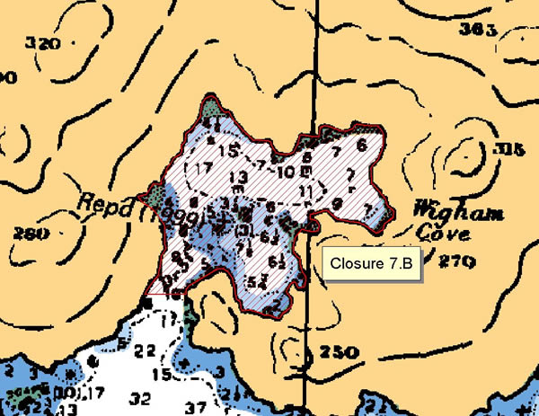
| 7.B Wigham Cove, Yeo Island | 7.B.png | The waters and intertidal foreshore of that portion of Subarea 7-15 inside a line that commences at 52°16.634'N, 128°10.600'W [Wigham Cove, Yeo Island], then following the shoreline northeasterly to 52°16.637'N, 128°10.478'W [Wigham Cove, Yeo Island], then westerly to the point of commencement. [NAD83] |
| 7-25.A | 7-25.A.png | That portion of Subarea 7-25 west of a line from Stubbs Point on Dodwell Island to a point on the northern island of the McNaughton Group at 51 degrees 58.6 minutes north latitude, 128 degrees 13.9 minutes west longitude, then following the eastern shore of that island to the southern tip of that island, then true south to the adjacent island, then westerly following along that island to the narrowest point between it and the island directly to the west (51 degrees 56.50 minutes north latitude, 128 degrees 14.04 minutes west longitude), then true west to that island (51 degrees 56.50 minutes north latitude, 128 degrees 14.074 minutes west longitude), then southerly and westerly along the shore of that island to the most southwestern point of that island at 51 degrees 56.02 minutes north latitude, 128 degrees 15.18 minutes west longitude, then true south to that island directly south of it, and then southerly to the southernmost point of that island at 51 degrees 54.27 minutes north latitude, 128 degrees 14.34 minutes west longitude, and then southerly to 51 degrees 53.97 minutes north latitude, 128 degrees 14.29 minutes west longitude on Hunter Island. |
| 7-25.B | 7-25.B.png | That portion of Subarea 7-25 east of a line from Stubbs Point on Dodwell Island to a point on the northern island of the McNaughton Group at 51 degrees 58.6 minutes north latitude, 128 degrees 13.9 minutes west longitude, then following the eastern shore of that island to the southern tip of that island, then true south to the adjacent island, then westerly following along that island to the narrowest point between it and the island directly to the west (51 degrees 56.50 minutes north latitude, 128 degrees 14.04 minutes west longitude), then true west to that island (51 degrees 56.50 minutes north latitude, 128 degrees 14.074 minutes west longitude), then southerly and westerly along the shore of that island to the most southwestern point of that island at 51 degrees 56.02 minutes north latitude, 128 degrees 15.18 minutes west longitude, then true south to that island directly south of it, and then southerly to the southernmost point of that island at 51 degrees 54.27 minutes north latitude, 128 degrees 14.34 minutes west longitude, and then southerly to 51 degrees 53.97 minutes north latitude, 128 degrees 14.29 minutes west longitude on Hunter Island. |
| 7-27.A | 7-27.A.png | That portion of Subarea 7-27 east of the meridian passing through 128 degrees 9 minutes west longitude and east of a line from the southeastern tip of Clare Island to the northeastern tip of Camel Island. |
| 7-27.B | 7-27.B.png | That portion of Subarea 7-27 west of the meridian passing through 128 degrees 9 minutes west longitude and west of a line from the southeastern tip of Clare Island to the northeastern tip of Camel Island. |
| 7-3.A | The waters and intertidal foreshore in that portion of Subarea 7-3 inside of a line that commences at 52°23.689'N, 128°37.561'W [Price Island], then east to 52°23.689'N, 128°30.557'W [in water], then south to 52°14.951'N, 128°30.557'W [in water], then northwesterly to 52°16.748'N, 128°39.932'W [Price Island], then following the shoreline north to the point of commencement. [NAD83] | |
| 7-3.B | The waters and intertidal foreshore in that portion of Subarea 7-3 inside of a line that commences at 52°28.987'N, 128°42.446'W [Swindle Island], then following the shoreline to 52°25.928'N, 128°29.891'W [Swindle Island], then southeasterly to 52°23.742'N, 128°28.721'W [Dowager Island], then following the shoreline southerly to 52°21.769'N, 128°27.485'W [Dowager Island], then south to 52°21.045'N, 128°27.485'W [Lady Douglas Island], then following the shoreline southerly to 52°19.098'N, 128°26.712'W [Lady Douglas Island], then southeasterly to 52°16.180'N, 128°24.447'W [Ivory Island], then southwesterly to 52°14.226'N, 128°26.496'W [Cape Swaine], then westerly to 52°14.951'N, 128°30.557'W [in water], then north to 52°23.689'N, 128°30.557'W [in water], then west to 52°23.689'N, 128°37.561'W [Price Island], then following the shoreline south to 52°28.929'N, 128°42.123'W [Price Island], then northwest to the point of commencement. [NAD83] |
Last updated: 2026-06-09
Related links
- Area maps
- Realtime bivalve shellfish safety harvesting map
- Information about recreational shellfish harvesting in BC
- Shellfish harvesting safety information
- Planned bivalve shellfish harvesting closures
- Identify your catch
Contact us
Email: DFO.PACCSSP-PCAMPAC.MPO@dfo-mpo.gc.ca
- Date modified: